Walk #443: Powfoot to Dumfries
 |
 |
|
General Data
| Date Walked | 15/05/2003 |
| County | Dumfries and Galloway |
| Start Location | Powfoot |
| End Location | Dumfries |
| Start time | 08.30 |
| End time | 18.11 |
| Distance | 19.9 miles |
| Description | This was a long road walk along the cost and then up the eastern bank of the River Nith to Dumfries. |
| Pack | Today I carried my 30-litre Karrimor HotRock rucksack, which was filled with my packed lunch, waterproof leggings, water bottle and a couple of spare shirts, together with the usual assortment of odds and ends. |
| Condition | I feel absolutely fine after this walk, and I could easily have walked further. The biggest problem that I had was with my right ankle, which gave a twinge or two during this walk. |
| Weather | Today was a mostly sunny and warm day, with only a few scattered clouds in the sky. It started off quite misty, but this soon lifted as the sun burnt through. There was not much wind, and it was the first day for some time that I could walk all day without my fleece on. |
| OS map | Landranger number 85 (Carlisle & Solway Firth, Gretna Green) and Landranger number 84 (Dumfries & Castle Douglas) |
 |
 |
|
 |
 |
|
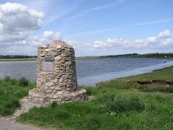
Map of the walk
Maps courtesy of Google Maps. Route for indicative purposes only, and may have been plotted after the walk. Please let me have comments on what you think of this new format. For a detailed table of timings for this walk, please see the table file.
Notes
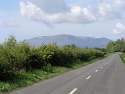
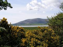
I realised that today was going to be along roads all day, and as the forecast was for a dry day I decided to walk in my trainers instead of my boots to protect my feet. The initial part of the walk was quite nice, even though it was along roads, as the views were quite nice and the lanes were surrounded by yellow gorse, the smell of which I love and makes me think of a walk that I did in northwest Scotland last year, a place that I shall be revisiting in a few months.
Ruthwell was quite a nice little village, with the white houses shining brightly in the sunshine. This was the home of the first savings bank in Scotland, which was opened in 1810 by the Reverand Henry Duncan of Ruthwell. A plaque on the building reads: 'To commemorate the first savings bank founded in this building in 1810 by the Reverend Henry Duncan, D.D. of Ruthwell. A measure which claimed ay his hands nearly 10 years of devoted work and pecuniary sacrifice. This tribute to his memory has been erected by his great granddaughter Sophy Hall in 1908'. Dr Duncan died on the 12th of February 1946, and the building is now a museum. Unfortunately this did not open until ten o'clock, and I did not fancy waiting around for it to open, which is a shame. A little way on down the road I met a couple of ladies who I chatted to for a few minutes, and they very kindly gave me a donation to the charity. The apse of Ruthwell church has a seventh-century cross in it, and I would not have minded seeing this, but unfortunately the church is about a kilometre north of the village and not on my route.
I met my first reference to Robert Burns at the Brow Well. This is where the Scottish bard went to take the waters in an attempt to heal himself, but unfortunately he died on the 21st July 1796. At the well there was a sign stating that the water was not fit to drink, and I can only hope that was not the case back in Burns's time. He is buried in St Michael's church in Dumfries, and the whole town is littered with references to his memory. I must admit that aside from Auld Lang Syne I do not know any of his work, and when I try and read his poetry I find it quite difficult because of the way it is written - then again, I do not like reading poetry at the best of times. A plaque by the well reads 'Burns was sent to Brow on the advice of his doctor, to drink the water of Brow Well (a chalybeate spring) and to bathe in the Solway. Brow at that time was a hamlet of 12 cottages, one of which was an Inn, used mainly by cattle drovers and by invalids seeking the assumed medicinal properties of the well water. (The Inn was destroyed in 1863, no one at that time thinking it of any great importance). The poet went to Brow on July 4th, 1796, wrote a note to John Clark of Locharwoods requesting the loan of a gig for his return journey to Dumfries because 'getting wet is perdition' and arrived in Dumfries on the 18th and died on the 21st.'.
On route I passed Caerlaverock Castle, and I could just make out the top of the turrets over the surrounding trees. The first castle at Caerlaverock was abandoned in 1277 when the buildings started to collapse, and a unique triangular fortress replaced this, which is now ruinous. My route avoided the castle itself, but I discovered afterwards it is possible to walk through the grounds past the castle if an entry charge is paid. After looking into this castle some more, I wish that I had gone around it, as it looks quite a fascinating place. The castle is part of a National Nature Reserve, which consists of 13,514 acres of land - an enormous area of land.
Sam picked me up at Kelton, a couple of miles to the north of Glencaple on the B725 road. I had completed a little over sixteen miles so far, and still had over three to go to get to Dumfries, my target for the day. We initially drove back to Powfoot, where we had a short photo shoot for a local paper with Margaret Barbour, before we drove to a Riding for the Disabled Group to the south of Lockerbie for a bit. This group does carriage driving, and they were busy with a group of adults when we arrived. The whole group of people were superb, and we had a lovely chat for an hour or so before we had to travel back so that I could continue the walk. I find it most uplifting to visit RDA groups as I walk, as it shows me what I am raising money for. At times the charity aspect of the walk seems to be a real drag, so visiting RDA groups at times helps encourage me in the fund-raising.
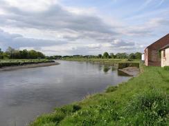
The little that I have seen of Dumfries so far is quite nice, and the approach to the town from the south along the river was very nice. The town is famous for its connections with Robert Burns, and there is a Burns Trail through the town that looks quite interesting. This evening we went into the centre of the town to do a collection in some pubs, but all the pubs that we passed were exceedingly quiet - the busiest only had about nine people in it, and we therefore decided it was not worth the effort of collecting in them. This is the first time that this has happened on this trip, which is quite surprising.
Directions
All of this walk follows a National Cycle Network route, and the going is easy along roads for most of the way. This walk starts off outside the hotel in Powfoot. Turn right and follow the road westwards along the coast, passing the golf course and then a caravan park. The road becomes a surfaced track, and at Riddingdyke it turns to the right to head northwards for a few hundred yards before ending at a T-junction with a road.
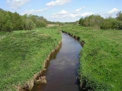
Turn left and follow this road westwards for a couple of kilometres until the farm is reached at Priestside, where it turns to the right to head northwards for a little over a kilometre. Take the first road off to the left, which heads westwards through the little village of Ruthwell before ending at the B725 road. Continue on westwards along the B725, passing the Brow Well and eventually crossing Lochar Water and reaching a T-junction in Bankend.
Turn left to head south along the B725 road, following it through Shhearington and past Caerlaverock Castle, before it turns to the right next to a car park and starts heading in a more northerly direction. The road passes through Glencaple and Kelton, and as it approaches the southern outskirts of Dumfries turn left to head westwards for a kilometre down to Kingholm Quay. At the quay turn right along a road, and then join the cycle path that heads along the eastern bank of the River Nith north into Dumfries. An area of attractive parkland is entered, and shortly before St Michael's Bridge over the river is met there is a car park, where this walk ends.
Distances
| From | To | Distance (m) | Ascent (ft) | Descent (ft) |
|---|---|---|---|---|
| Powfoot | Bankend | 9.1 | 207 | 187 |
| Bankend | Dumfries | 10.8 | 479 | 509 |
This makes a total distance of 19.9 miles, with 686 feet of ascent and 696 feet of descent.
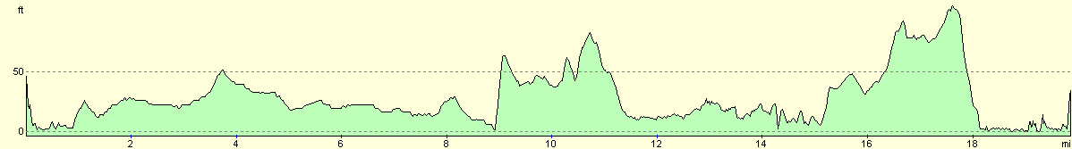
For more information on profiles, ascents and descents, see this page
Accommodation
We parked Mervan in a car park on the eastern bank of the river near St Michael's Bridge. This was quite near the centre of the town, and was handy for several pubs.
Disclaimer
Please note that I take no responsibility for anything that may happen when following these directions. If you intend to follow this route, then please use the relevant maps and check the route out before you go out. As always when walking, use common sense and you should be fine.
If you find any information on any of these routes that is inaccurate, or you wish to add anything, then please email me.
All images on this site are © of the author. Any reproduction, retransmissions, or republication of all or part of any document found on this site is expressly prohibited, unless the author has explicitly granted its prior written consent to so reproduce, retransmit, or republish the material. All other rights reserved.
Although this site includes links providing convenient direct access to other Internet sites, I do not endorse, approve, certify or make warranties or representations as to the accuracy of the information on these sites.
And finally, enjoy your walking!
This walk was mentioned in the following routes:
| My walk around the coastline of Britain |
Nearby walks
| # | Title | Walk length (miles) |
|---|---|---|
| 438 | Allonby to Angerton | 24.1 |
| 439 | Angerton to Burgh by Sands | 17.3 |
| 442 | Gretna to Powfoot | 17.9 |
|
|

|