Walk #859: Bath to Avonmouth via Bristol and the River Avon Trail
 |
 |
|
General Data
| Date Walked | 26/05/2010 |
| County | Avon |
| Start Location | Bath Station |
| End Location | Avonmouth Station |
| Start time | 08.29 |
| End time | 17.53 |
| Distance | 26.3 miles |
| Description | This was a very pleasant walk following the Avon Valley path as it follows the River Avon westwards towards the sea. |
| Pack | Today I carried my 30-litre Karrimor rucksack, filled with water, my waterproofs, a couple of books and other odds and ends. |
| Condition | I am tired after this walk and my feet are a little hot, but otherwise I feel fine. |
| Weather | The day was a mixture of sunshine and cloud; it was fairly warm when the sun was shining, and cooler when under cloud. There was a pleasant breeze that helped cool me down. |
| OS map | Landranger number 172 (Bristol & Bath, Thornbury & Chew Magna) |
 |
 |
|
 |
 |
|
Map of the walk
Maps courtesy of Google Maps. Route for indicative purposes only, and may have been plotted after the walk. Please let me have comments on what you think of this new format. For a detailed table of timings for this walk, please see the table file.
 |
 |
|
 |
 |
|
Notes
For years I have wanted to walk the < ahref="http://www.bristolbathrailwaypath.org.uk/home.shtml" target="_blank">Bristol and Bath Railway path, the first path opened by Sustrans between 1979 and 1986. Since those early days Sustrans have opened over 10,000 miles of cycle paths, 70% of which are on roads (the 10,000th mile was opened just outside my old flat in Great Shelford, and was marked with the colour-codes of a strand of DNA on the tarmac). Although I do not agree with everything they do, they have certainly improved the urban and rural environment. The cycle path was at the very top of the todo' list that I created over ten years ago, and the walk I did last week to Bath was meant so that I could do this walk.
However, quick research on the Internet gave me another, more intriguing option. The Avon Valley Trail also runs between the two cities, this time following the River Avon. A glance on the map showed that it would be easy to continue along the trail from Bristol to Avonmouth, where I would connect up with my coastal walk. It would be a long day, but I felt fit and able. Therefore, instead of doing the walk I have always wanted to, I was setting off on a totally different one!
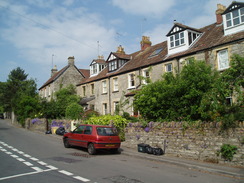
The train deposited me off at Bath station and I got ready for the walk. Strangely enough, the cost of a return ticket from Romsey to Bristol is the same as that for Romsey to Bath, despite the former being a longer journey. I was slightly hungry, so I nipped into the Upper Crust and bought myself a sandwich, and started to munch it as I passed the bus station and joined the River Avon Trail.
I had walked this first couple of miles last week, and it was surprising how busy the path was with commuters cycling towards the city centre. It meant that I had to keep my eyes and ears open for cyclists approaching from ahead and behind as I walked, especially as the path was a little narrow in places. Matters improved as I headed westwards, passing Weston Lock and under the railway bridge that carried the railway path over the canal. A little further on the towpath crossed the entrance to a marina and reached New Bridge, which carries the A4 over the canal.
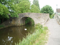
The footpath crossed over to follow the southern side of the river, and the pavement on the bridge was narrow. In the middle of the bridge was a marker denoting the boundary between Somerset CC and the City of Bath. Underneath a change in the style of the arches showed that the bridge had been widened sometime in the past - although not enough for modern traffic. Nearby was an information board on the local area, one of many that were usefully strewn along the trail.
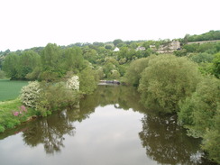
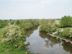
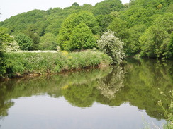
What followed was a pleasant riverside stroll alongside the Avon. The valley was broad, with the cycle path and the GWR main line off to the left. The path passed under a bridge that carries the cycle path over the river, and then ran through a more overgrown stretch with the river on the right and the GWR railway line on the left. It was a really pleasant stretch to walk as the sun shone down on the river.
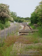
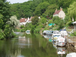
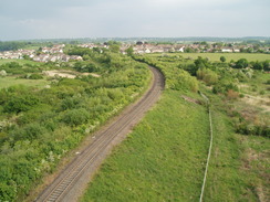
After crossing a bridge over an entrance to a marina the path joined a road in Saltford (apparently called such because historically the river was tidal to this point; Freshford on the eastern side of Bath was named because the water was fresh. Weirs mean that the tidal river now ends at Bristol). After passing through Saltford the path climbs up an embankment to join the cycle path along the old railway line. It made for a pleasant walk, with a good tarmac surface underfoot. After a while I came across a series of messages painted on the tarmac - "No rails - no fences" amongst others. A few yards further on I unexpectedly came across the end of a railway line - the Avon Valley Railway had been expanded southwards since my 1:50,000 OS map had been printed.
There are plans to expand the railway further southwards towards Bath, and the graffiti artist does not apparently approve of this. The cycle path would still exist (as it does alongside the line at the moment), and an extension to the railway might be useful to the local area. Yet Sustrans - remember SUStainable TRANSport - are, IMHO wrongly - against the idea.
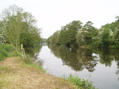
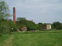
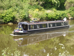
The path passed a newly-built station and approached another bridge over the river. After crossing this the path dropped down to rejoin the northern bank of the river. What followed was a satisfying walk through green fields alongside the river. Soon some attractive stone-built factories appeared on the other side of the river, with canal boats moored outside and around. I have no idea what these large buildings do, but I guessed they make or renovate canal boats. This could well be wrong...
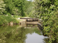
The river soon reached a road bridge and Keynsham Lock. Beyond this, the views were dominated by the massive Cadbury's chocolate factory on the other side of the river, controversially due to be closed at the cost of hundreds of jobs. The path remains on the northern side of the river as it curves around three sides of the factory, kinking around to reach an attractive riverside pub beside a lock. Unfortunately the pub was not due to open for ten minutes, and as I did not want to wait I strolled on, immediately passing under a bridge that carries the A4174 dual carriagreway high overhead.
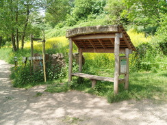
From here on the banks of the valley started to encroach on the river, giving high cliffs to the right. Despite this the nature of the river hardly changed, and still flowed gently downstream. A rustic shelter on the right marked the Conham ferry landing, where for years a ferry has transported people across to Beeses Riverside Bar and Tea Gardens on the other bank. Unfortunately it was not running on this weekday, but I can imagine that it is popular enough at the weekends, especially as the ferry landing is a lovely tree-lined place to wait.
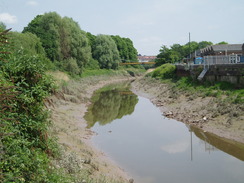
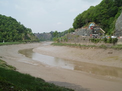
Eventually Netham Lock was reached, where the path left the navigable stretch of river headed directly towards the centre of Bristol. The path followed this for a short distance before heading away through an industrial estate and between narrow, high palisade fences that eventually ended under an old railway bridge. Here the path joined the first tidal stretch of the river, with expansive mud flats visible. A few minutes before I had been walking along a nice, non-tidal river; now it was as if someone had pulled the plug out.
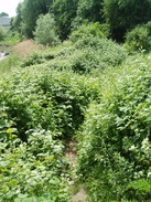
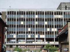
The next stretch of path was very overgrown, and I was glad that I had not worn shorts as long brambles, nettles and grass tried to trip me up. To make matters worse the path slanted from right to left meaning that it was hard at times to find my footing. It was a relief when a much better path started, looping around alongside the river. Soon a hideous high-rise building appeared on the right, dominating the centre of Bristol. It was abandoned and windowless, and I think it may have once been a hotel. The city deserves better.
Here the Avon Valley Trail left to loop through the city to the north; the route was not too clear on the 1:50,000 OS map, and as there was still a long way to walk I decided to take a more direct route. This took me under a long bridge - more like a tunnel - right under the railway lines and platforms of Bristol Temple Meads station. I was starting to feel tired by now, and I diverted off my route to head up to the station. The station buildings are all very grand and impressive, but behind is that same abandoned building.
W.H.Smiths was my port of call, and I bought a bottle of water and a can of Red Bull. The handle of the bag split as I walked out of the station, and as I opened the can it spurted all over me, covering me with sticky liquid. From the station I headed westwards along the New Cut, a river that had been cut to make navigation easier and to bypass the Floating Harbour. This would have been a particularly nice stroll if this was a normal river; unfortunately the large expanse of mud flats did rather spoil the views. Despite this, it was an enjoyable walk.
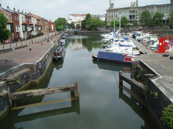
After a while an old railway line joined me on the right, squeezing the path between it and the river to my left. This was once part of the old railway line leading to the floating harbour, and is now part of the Bristol Harbour Railway. No trains were running as I strolled past, but there was still plenty of interest to see. I soon saw a pub on the other side of the road, but there was no way across the fences to reach it without backtracking to a footbridge. Instead I plodded on, eventually reaching the point where the railway turned to cross the New Cut on a bridge. By now I had rejoined the Avon Valley Trail.
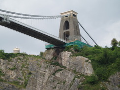
This bridge was interesting - the rails were on the left and obviously long disused; at one point it was a double-decker bridge, with a road overhead. This had been dismantled and half the bridge converted to a footpath. On the other side of the bridge the rails had been removed and a cycle path replaced it. Here I turned to the right to follow the south bank of the river as it headed into the Avon Gorge. Pretty Georgian houses stretched up the hillside on the other side of the valley, below which were the remains of some wooden staithes. Soon the hillside became steeper as I approached the Clifton suspension bridge.
This is infamous as being the bridge designed by Isambard Kingdom Brunel in response to a competition to span the gorge. At the time it was believed to be an impossible distance to span, and some of the competition entries from reputable engineers were fantastical. Brunel's entry won the competition in 1831 and work started in 1836; unfortunately the money ran out and it was not completed. After he died the money was raised and the gorge spanned in 1864. It is truly a magnificent memorial to the great man.
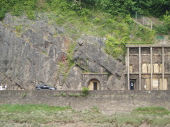
A few holes in the cliffs on the other side of the valley showed entrances and exits from the cliff - I assume part of the Clifton Rocks Railway, a funicular railway that was actually built into the cliff to prevent ruining the views. It must have been an amazing tunnelling project, but lasted for only forty years after it was opened in 1893.
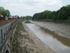
A road runs along the base of the gorge on the other, eastern, side of the river. Evidently rock falls are a problem in this area as the road disappears into a short concrete tunnel to protect the carriageway. The path on my side of the river is trapped between the river on the right and the Portishead railway line on the left. This line was recently reopened to take new cars that had been imported into the Royal Portbury Dock. Locals hope for it to be reopened to passengers from Portishead itself, but there are complications in doing that. It would certainly have given me more options at the end of this walk!
The railway also dived into a short tunnel as the sides of the gorge encroached towards the river. The railway line was about ten feet above the path, out of view but always present. I could not help but keep looking back over my shoulder towards the Clifton suspension bridge. The gorge slowly started expanding out as the tide rose, reducing the expanse of the mudflats. I was aware that the Bristol Channel has one of the highest tidal ranges in the world, but I was not expecting the tide to come in quite so quickly!
I stopped for a brief rest on a bench in the middle of nowhere and phoned up my wife. Sencan told me the train times back from Avonmouth - I would have to hurry to reach the train after next. Therefore I cut my stop short and headed off as the river curved around sharply. Apparently many ships ran aground on this bend, and after the Gypsy ran aground in 1878 the railway opened a station especially so people could go to see the beached vessel!
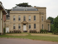
The path left the village and headed inland slightly, passing a pond to reach the old hospital at Ham Green; this is much smaller than it once was. The main building was fairly grand - the entire aspect inspires confidence, especially when compared to some of the brutalist concrete hospital buildings that are scattered around the country. The stonework and surrounding gardens made me feel as though I could enter the building and would recover from whatever ailed me.
Shortly afterwards I entered the village of Pill. It was not clear where the Avon Valley Trail headed from here (the trail itself ends in the village), so I headed down a path through a pretty park with some good views over towards the M5 Avonmouth bridge. On the way I chatted to a local couple about the area.
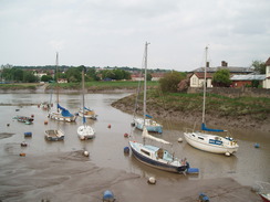
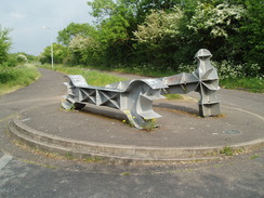
Pill was once home to the Bristol Pilot Cutters - fast sailing ships that pilots used to get out to incoming ships. Pilots were highly-experienced local sailors who knew the local waters well. They were needed as the Bristol Channel and the River Avon up to Bristol were hazardous for navigation. The first pilot to reach a ship would get the job, so it was vital to reach them fast. I walked through the centre of the village, and then along the southern bank of the river, with the M5 Avonmouth bridge dominating the view overhead. Here I rejoined the route that I had taken on my Coastwalk, passing a large graffiti-laden sculpture in the shape of a spanner and hammer before climbing up onto the southern approach to the bridge.
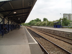
It was a pleasant walk over the bridge; an area on the other side was filled with a massive number of cars that had arrived at the docks. The bridge was built in 1969=1973, the long period required due to the collapse of a similar structure in Germany during construction. It is technically called a 'Cantilever bridge, haunched, hollow box', with a main span of 164 metres. It was widened to four lanes in recent years. It soars high above the river to allow tall ships underneath, yet apparently few ships ever make the journey nowadays. The tide was almost completely in by now, and the views back upstream were pleasant. Some steps descended down the other side of the bridge and a path passed a closed sports centre as I headed into Avonmouth. I arrived at Avonmouth station with about eight minutes to spare for the train, happy at having completed my longest walk for some time. The train was on time, although the Pacer unit had a rough ride' the first part of a long journey that would not see me home until after nine.
 |
 |
|
 |
 |
|
Directions
This walk starts off at Bath Spa station. Leave the station and turn left along Dorchester Street, passing the bus station on the left. Churchill Bridge is a short distance further on the left; carefully cross the road and then turn to the left to join the cycle path that runs along the northern bank of the River Avon. This is the River Avon Trail, for which an on-line guidebook is available.
The path continues along the northern bank of the river, passing Weston Lock and climbing over the entrance into a marina. After nearly three miles New Bridge is reached. Pass under the bridge and then climb up onto the bridge. Carefully cross using the narrow pavement and descend down on the other side of the river. Continue on westwards, with the river on the right. It curves around before paralleling the GWR main railway line. After a couple of miles the path climbs up to cross a bridge over the entrance to another marina. Keep to the water's edge as the path continues on for a short distance, crossing a grassy area before reaching a road in Saltford.
Turn right to follow the road north through Saltford, passing a car park and public toilets on the left. At the top of the hill turn right to head downhill. When a pub is reached on the right, turn right to enter the car park and head for a path that leads up to the top of an old railway embankment. At the top turn left and follow the cycle path as it heads northwards for nearly a mile. Cross another bridge over the river, and then turn left to head down to the northern river bank.
Follow the river for seven and a half miles as it winds past Keynsham, Harnham and Conham. When Netham Lock is reached continue on for a couple of hundred yards until Marsh Lane is reached (at ST612727). Turn left down Marsh Lane to reach Feeder Road. Turn right along this, and then immediately left down Kings Park Avenue, which takes you into an industrial estate. When the road curves to the right, takea foootpath that leads off to the left between high barriers. This swings to the left and ends up by the river directly underneath an old railway bridge.
Turn right to walk along the northern bank of the river, which is now tidal. The path is rough until it passes under a new road bridge, after which it widens out and becomes much more pleasant. Continue along the river as it curves to the right, passes under a railway bridge, and then to the left to approach a massive bridge that carries Bristol Temple Meads station over the river. Here I left the route of the River Avon Trail for a few miles by turning right and then left to rejoin the Feeder Road. Continue westwards along this as it heads under the long bridge below the station. It ends at the A4 on the other side.
If you wish to visit Temple Meads Station then turn right for fifrty yards, then right up the station approach. If not, then carefully cross the A4 and head on westwards along the A370 Clarence Road with the New Cut (part of the river) on the left. Another large roundabout is soon reached; carefully cross this and continue on down Commercial Road, with the river on the left and part of the Floating Harbour on the right. The road jinks to the right to pass over a (now blocked) entrance to the harbour, and then turn left to rejoin the river. Head down to the left to take a footpath that runs along the northern bank of the river. Soon a railway line joins from the right, trapping the path between rail and water. The River Avon Trail is rejoined halfway down this stretch.
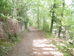
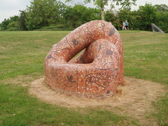
A bridge is reached at ST569721. Turn left to cross this and then immediately right to start following the western bank of the river northwards. Continue on for six miles as the path transits the Clifton Gorge. Eventually the valley widens out. At ST537762, shortly after a tight left-hand bend, the path leaves the river bank and joins a track called Chapel Pill Lane. This heads up southwestwards, passing Chapel Pill Farm and the end of a small lake before reaching Ham Green Hospital. Diaganolly cross an area of parkland, passing a raised circular area, and then head downhill with the railway line on the left. This ends at a Watchhouse Road in Pill.
Turn left to head under a railway viaduct, and then by a pub turn right to head along Underbanks, with a river channel on the right. When the river is reached after a short distance turn left along Marine Parade. This curves to the left away from the river, and then right before ending at Avon Road. Turn right down Avon Road and then left to follow a cycle path that runs alongside the railway line. When the path splits by a sculpture turn right to follow a path onto the southern end of the M5 Avnmouth Bridge.
Turn right and cross the Avonmouth Bridge. Descend some steps on the northern side and directly pass under the bridge. Comntinue straight on across a derelict area to reach the A4 dual carriageway. Turn right to parallel the A4 northwestwards; after a short distance a pedestrian footbridge is reached. Cross this to reach the western side of the road, and then head up to the roundabout.
Take the first road off the to the left, Avonmouth Road, and follow it northwestwards for nearly half a mile. Just before the road turns to the right, head left down Gloucester Road. Avonmouth railway station is a few yards away on the left. Trains back to Bristol depart from the nearest platform.
Distances
| From | To | Distance (m) | Ascent (ft) | Descent (ft) |
|---|---|---|---|---|
| Bath Spa station | Keynsham | 8.2 | 226 | 262 |
| Keynsham | Bristol Temple Meads station | 8.1 | 659 | 686 |
| Bristol Temple Meads station | Pill | 7.3 | 951 | 912 |
| Pill | Avonmouth station | 2.7 | 105 | 138 |
This makes a total distance of 26.3 miles, with 1941 feet of ascent and 1998 feet of descent.
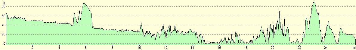
For more information on profiles, ascents and descents, see this page
Transport
There are regular train services running from Avonmouth to Bristol temple Meads, and then from Bristol Temple Meads to Bath Spa; the ticket for the first leg was £2. The journey may take a couple of hours due to the need to change at Bristol.
 |
 |
|
 |
 |
|
 |
 |
|
 |
 |
|
 |
 |
|
 |
 |
|
 |
 |
|
 |
 |
|
Disclaimer
Please note that I take no responsibility for anything that may happen when following these directions. If you intend to follow this route, then please use the relevant maps and check the route out before you go out. As always when walking, use common sense and you should be fine.
If you find any information on any of these routes that is inaccurate, or you wish to add anything, then please email me.
All images on this site are © of the author. Any reproduction, retransmissions, or republication of all or part of any document found on this site is expressly prohibited, unless the author has explicitly granted its prior written consent to so reproduce, retransmit, or republish the material. All other rights reserved.
Although this site includes links providing convenient direct access to other Internet sites, I do not endorse, approve, certify or make warranties or representations as to the accuracy of the information on these sites.
And finally, enjoy your walking!
Nearby walks
| # | Title | Walk length (miles) |
|---|---|---|
| 72 | Bath to Devizes | 19.3 |
| 126 | Farrington Gurney to Bath | 12.6 |
| 369 | Clevedon to Severn Beach | 18.6 |
|
|

|