Walk #860: Southampton to Hythe
 |
 |
|
General Data
| Date Walked | 30/06/2010 |
| County | Hampshire |
| Start Location | Southampton city centre |
| End Location | Hythe Ferry |
| Start time | 08.53 |
| End time | 14.54 |
| Distance | 14.6 miles |
| Description | This was a fairly uninteresting walk around the mouth of the River Test. |
| Pack | Today I carried my 30-litre Karrimor rucksack, filled with water, my waterproofs, a couple of books and other odds and ends. |
| Condition | I feel absolutely fine after this walk. |
| Weather | The day was fairly warm, especially when the sun was shining. Fortunately there was a fair bit of cloud at times, which helped keep me cool. |
| OS map | Landranger number 196 (The Solent & The Isle of Wight, Southampton & Portsmouth) |
 |
 |
|
Map of the walk
Maps courtesy of Google Maps. Route for indicative purposes only, and may have been plotted after the walk. Please let me have comments on what you think of this new format. For a detailed table of timings for this walk, please see the table file.
 |
 |
|
Notes
It had been over a month since my last walk, mainly due to some problems I have been having with my neck and shoulder (which itself seems like a recurrence of a problem that I had on my coastal walk). Physiotherapy had helped, and as it mostly seemed worse when lying than standing, it seemed like a good idea to attempt a walk. My car was booked in for a service and MOT in Southampton, and as it would not be ready for seven hours it seemed like a good opportunity for a walk.
Since moving down to the south coast I have repeated many of the coastal walks that I did eight years ago, but there was a missing link between Southampton and Hythe, on either side of the River Test. Much of the short walk would be along main roads, which was why I had delayed so long before doing this particular walk.
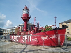
I dropped my car of at the dealers and started to head through the city towards the starting point at Ocean Village. There was a much more direct route following the ring road, but I felt like a little wander. Eventually I reached Ocean Village, where the old Calshot lightship - a large red vessel - was being dug out ready for its imminent move to elsewhere in the city. I love the Ocean Village area - it was named after the old Ocean Terminal, an art deco terminal that allowed passengers to go directly from trains onto the liners that used to call at Southampton. The terminal was demolished in the eighties, when it looked as though the day of the large liners was over. It was a shame, especially when a new structure has recently opened nearby to cater for the ever-increasing size and numbers of cruise ships that use the port.
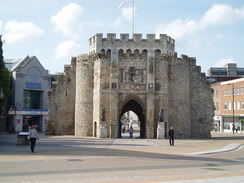
The first part of the walk took me towards the old walls of the city, passing the Platform - one of our favourite pubs. It is strange to think that at one time the sea came directly up to the city walls; now they are quite a distance away, the land between having been reclaimed. The Platform is named after a walkway that used to exist between the sea and the walls - Jane Austen allegedly walked along them during her stay in the city.
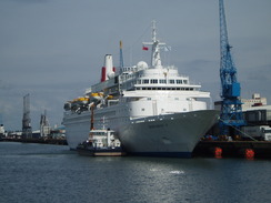
I diverted off route slightly to take a trip through Mayflower Park, an area of land trapped between the docks and the Isle of Wight Ferries. It was constructed in the 1920s to provide locals with an amenity space to replace that lost when the massive docks area was reclaimed from the sea. It is a lovely, grassy area. Workmen were starting to build the pontoons ready for the Southampton Boat Show in September, and a grey warship - HMS Dauntless or Daring - was visible on the other side of the river. A cruise ship was berthed nearby, but it was not one of the large ones such as 'Independence of the Seas'. It is quite a sight to stand at the very end of the park and look up at the bows of one of these leviathans.
Unfortunately that was the end of the scenic part of this walk. I followed the dual carriageway as it passed the massive new Ikea store - a blue monolith that seems totally out of place, with little to commend it to the area. Soon the pavement ended, and I was forced to walk along a narrow verge between the road and a fence; containers were stacked five-high on the other side of the fence, an indication that the docks had finally begun. I last walked this stretch on Boxing Day 2002, and the traffic was naturally far worse.
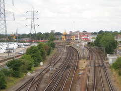
The situation did not improve as the road - now six lanes wide - rose up to cross a railway line. Although the verge was wide enough to walk along without risking life and limb on the tarmac, overgrown vegetation narrowed the walkable route considerably. It was a relief when, on the other side of the river, a road came in on the left. This gave me a much safer and quieter route.
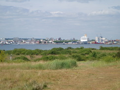
The side road paralleled the main road, but there was little of interest to see. I stopped off at a petrol station to buy a few snacks before putting my head down for the next couple of miles. Eventually I reached the bridge that carries the A33 over the River Test. Tidal mudflats spanned the gap between the bridge and the railway line, and beyond that were the cranes of Southampton docks. It felt a relief to be leaving the main road behind.
Another bridge took the road over the railway, after which a cycle path took me down to meet a road in Eling. Soon I reached Eling Wharf, which felt like a strangely rural place after the mad, hectic traffic that had dominated the walk so far. A multitude of sailing boats filled the little inlet, along with some brethren stranded on the side of the wharf. The tranquil scene was spoilt only by the stacks of cargo containers in a nearby yard. The wharf marks the start of the Test Way, a long-distance walk that ends in the north of Hampshire. The biggest draw, however, is the tidal mill that is still used to grind grain. It is well worth a visit, especially if you also take in the nearby visitor's centre.
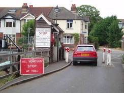
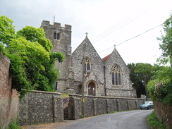
I expected the walk along the western bank of the Test to be easier, with quieter roads. After crossing a toll-bridge by the dial mill I climbed the biggest hill of the day (a mere twenty feet or so) and passed Eling church. A short distance down the road were two pubs, one on either side of the road. I resisted the temptation to go in and continued on. Unfortunately what I remembered as being quiet roads on the way to Marchwood turned out to be fairly busy, with lorries heading towards the nearby waste disposal site and incinerator. It was a relief when I passed them and started along the looping road that headed around the northern side of Marchwood.
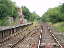
Soon I saw railway wagons on the other side of a chain-link fence, and in the distance were a couple of shunting locomotives. This was the Marchwood MOD depot, from where many materials of war go abroad. In the past I have seen rows of tanks and armoured personnel carriers on well wagons, so the ordinary-looking wagons were a little of a let-down. It would be expected that such a base would have reduced in size over the decades, but in reality it has been expanded in the last decade.
There was little of obvious interest in Marchwood, aside from a church and a level crossing that carries the freight line from Fawley oil refinery across the road (the old station platforms are extant on the southern side of the road). I strode on through, and soon came across the Pilgrim's Inn, just outside the town. I had a little time in hand, so instead of plodding on I went in and ordered a pint of bitter and another of orange and lemonade - my usual walking fare. It was fairly warm, so I sat outside on a bench, watching a dog running around. It was a surprisingly pleasant place to stop for a rest, given that a main road lay just beyond the hedge.
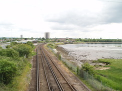
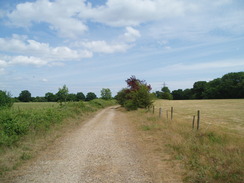
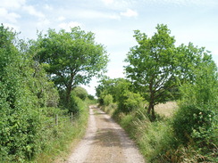
A short stroll along the road led me to a track off to the left, crossing the railway line to Fawley refinery. On my previous walk I had followed roads to Hythe via Dibden Purlieu; there was, however, a footpath on the map that took a more coastal (and traffic-free) route. I am unsure why I had not taken this on my coast walk, but I decided to do it today. The vast majority of the stretch was along good tracks, before a footpath led me on into Hythe. It was a pleasant enough walk, although I longed to find a route closer to the sea. A large sign forbid access, however, and I did not feel up to risking it.
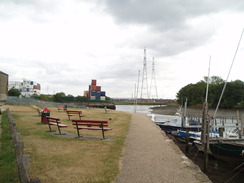
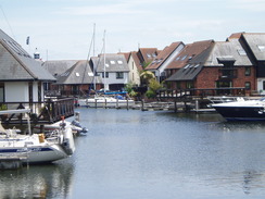
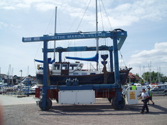
The path ended at a road just before Hythe Village Marina. Instead of heading directly towards the pier, I turned left to walk around the marina. It is a combination of housing estate and marina, with every house seeming to have a mooring space for boats. I walked around the marina hoping to cross the lock gates to access the other side, but unfortunately the public could not cross. Instead I watched as a large mobile crane carefully placed a suspended yacht into the water. I have seen many of the strange-looking machines during my walks, but it was the first time I had ever seen one actually working.
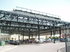
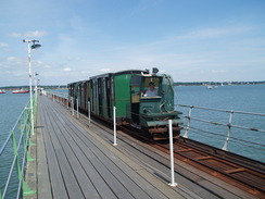
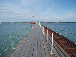
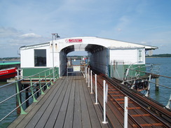
I had to walk back around the marina and make my way to the pier the long way - no great hardship. I bought a ticket from the small office and started walking down the pier. A railway runs along the 700-yard long pier -it is the oldest continually-operating pier railway in the world. In 2003 the pier was severed when a dredger ran through the middle of it. The captain had been drinking heavily, and he was subsequently jailed for eight months. The repair work took a few months, which seems like a stunningly short period in which to replace fifty metres of pier.
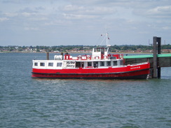
I chose to walk instead of taking the train, and soon reached the waiting rooms at the far end. A ferry had just left, and so I sat down and watched the water. I must admit to loving Hythe Pier - it is such a magnificent place to wait, with views up and down the Solent. The ferry soon arrived and I was treated to a trip across Southampton Water, passing the many tugboats that are berthed on the river. It had hardly been a classic day's walk, but the ferry trip at the end had made it seem much better than it really was.
 |
 |
|
Directions
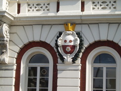
This walk starts off outside the old Borders Store in Southampton (currently being outfitted to become a different store). The initial stretch of the walk is to walk through the city to Ocean Village; pick a route of your own, but I headed through the West Quay Shopping Centre to reach Above Bar Street. Turn right down this to reach the magnificent stone gateway of Bargate. Continue on southwards down the hill; when Bernard Street is reached turn right to head eastwards. Turn right down Queen's Way for a short distance until it ends at Briton Street. Turn left down this and then join Queen's Terrace, with Queens Park on the right. When this ends at the old railway hotel, turn right and then left to walk eastwards down Canute Road. This road crosses the railway line into the docks; take the second road to the right, Ocean Way, and immediately on the right is the car park for the cinema.
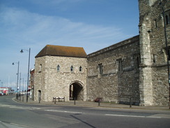
Leave the car park and turn left to return to Canute Road. Turn left down Canute Road and cross over the railway line once more. When Canute Road ends head straight on down Platform Road past the fifteenth century God's House Tower, where the road becomes Town Quay. God's House Tower is part of the city walls, which continue on the northern side of the road until a roundabout is reached. At the roundabout continue straight on along the dual carriageway West Quay Road.
There is no pavement beside West Quay Road, and in summer vegetation reduces the gap. When the A33 Mountbatten Way comes in from the right, turn left and follow the road as it swings to the left to climb up onto a bridge over the railway line. Again, the verge is narrow in places as it squeezes between the road and the adjacent container depot. The road descends on the western side of the bridge; when you can drop down onto Payne's Road on the left. Pass under the pedestrian footbridge that leads to Millbrook Station. From here the going becomes easier, as there are a series of roads that parallel the A33. Continue on along the left-hand side of the road as it passes two roundabouts, the first giving access to the A35 and the second one the M271.
Keep low at this second roundabout, avoiding the Redbridge Flyover. A cycle path leads on as the road curves to the left, climbing onto a bridge over the River Test on the Redbridge Causeway. Take a slip road that leads off to the left, and before an overbridge is reached turn left along a cycle path that climbs up onto the bridge on top. Turn left and follow the road as it passes to the right of a works. The cycle path soon branches down to the left, signposted for Eling and Marchwood. This passes a large brick wall on the right. At the bottom of this path Eling Lane is met. Turn left down Eling Lane and follow it as it curves to the right towards Eling Wharf. At the wharf turn left to cross Bartley Water on a toll bridge beside a tidal mill.
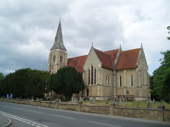
On the other side of the bridge the road climbs up past Eling Church and the Village Bells Pub, where the road becomes Bury Lane. When Bury Lane ends at a T-junction a short distance later turn left down Marchwood Road. This road heads southeastwards and as it passes Bury Farm it becomes Bury Road. When a roundabout to the northwest of Marchwood is reached (near to a sewage works and refuse incineration plant), turn left down Normandy Way. This road curves around the northern part of the village. When Cracknore Hard Lane is reached on the left the road becomes Main Road and curves southwestwards through the village past St John the Baptist Church and across a level crossing over a railway line.
Past the level crossing the road swings around to the left and becomes Hythe Road. This roughly parallels the A326 road as it heads southeastwards out of Marchwood. Pass the Pilgrim Inn on the right, and then at SU393094 Turn left along a track. This immediately crosses a railway line and reaches Veal's Farm. At the farm turn right and start following a track eastwards.
Continue on this track as it curves to head southeastwards, angling towards the railway embankment. At SU409086 the track curves sharply to the left. Here the footpath leaves the track and turns right to head eastwards along the southern bank of a drainage ditch, with the track on the northern bank. The footpath emerges out onto a road by the Hythe Village Marina. If you wish to explore the village then turn left; if not, then continue straight on along the footpath. It joins a road, which can be followed into the centre of Hythe. The bus station is reached on the left, and the entrance to Hythe Pier is on the left. Pay the fee, and walk up the pier to the pier head to catch the ferry back to Southampton.
 |
 |
|
Distances
| From | To | Distance (m) | Ascent (ft) | Descent (ft) |
|---|---|---|---|---|
| Southampton | Eling Wharf | 7.1 | 98 | 121 |
| Eling Wharf | End of Hythe Pier | 7.5 | 167 | 171 |
This makes a total distance of 14.6 miles, with 265 feet of ascent and 292 feet of descent.
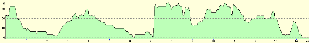
For more information on profiles, ascents and descents, see this page
Accommodation
A ferry runs from Hythe Pier to the Town Quay in Southampton. Details can be found on the Hythe Ferry website.
 |
 |
|
 |
 |
|
 |
 |
|
 |
 |
|
 |
 |
|
 |
 |
|
 |
 |
|
 |
 |
|
 |
 |
|
 |
Disclaimer
Please note that I take no responsibility for anything that may happen when following these directions. If you intend to follow this route, then please use the relevant maps and check the route out before you go out. As always when walking, use common sense and you should be fine.
If you find any information on any of these routes that is inaccurate, or you wish to add anything, then please email me.
All images on this site are © of the author. Any reproduction, retransmissions, or republication of all or part of any document found on this site is expressly prohibited, unless the author has explicitly granted its prior written consent to so reproduce, retransmit, or republish the material. All other rights reserved.
Although this site includes links providing convenient direct access to other Internet sites, I do not endorse, approve, certify or make warranties or representations as to the accuracy of the information on these sites.
And finally, enjoy your walking!
Nearby walks
| # | Title | Walk length (miles) |
|---|---|---|
| 306 | Browndown to Bursledon | 12.9 |
| 307 | Bursledon to Southampton | 9.2 |
| 308 | Southampton to Fawley | 16.4 |
|
|

|