Walk #105: Newmarket to Bury St Edmunds
 |
 |
|
General Data
| Date Walked | 19/08/2000 |
| County | Cambridgeshire, Suffolk |
| Start Location | Newmarket |
| End Location | Bury St Edmunds |
| Start time | 09.50 |
| End time | 17.12 |
| Distance | 21.7 miles |
| Description | This was a long walk, mostly along roads, taking in the highest point in Suffolk. |
| Pack | Today I carried no food, spare clothes or sleeping bag. I did have my trainers packed away securely in the pack. |
| Condition | I am feeling reasonable after this walk. I had a few slight aches and pains, and I suffered slightly from the heat. I used my old pair of Salamon walking boots, and the underside of my feet have not suffered as much as they do with my new pair. |
| Weather | The weather forecast was for some heavy rain, with the weather brightening up later. I delayed the start of the walk so that I could see what was happening, and when it did not look too bad drove to Newmarket. I was rewarded with a warm day with periods of strong sunshine, although the sky was cloudy most of the time. There was some wind which helped me keep cool, but also prevented me from noticing that I was getting sunburnt. |
| OS map | Landranger number 154 (Cambridge & Newmarket, Saffron Walden) and Landranger number 155 (Bury St Edmunds, Sudbury & Stowmarket) |
 |
Map of the walk
Maps courtesy of Google Maps. Route for indicative purposes only, and may have been plotted after the walk. Please let me have comments on what you think of this new format. For a detailed table of timings for this walk, please see the table file.
Notes
The main aim of this walk was to visit the highest point of Suffolk, which lies in a fairly undistinguished area near Great Wood. It also proved useful as I could use it to extend a walk eastwards from Cambridge down towards Ipswich.
Over recent walks I had been having trouble with my walking boots hurting the underside of my feet when the walk involved lots of road walking, so I decided to try my old pair of boots now that the split in the leather stitching has been repaired. Fortunately my feet did not suffer as much as they did in my new boots on a shorter walk, so I have decided that in the future I will use my new boots for off-road walking, and my old ones for walks that involve significant amounts of road walking.
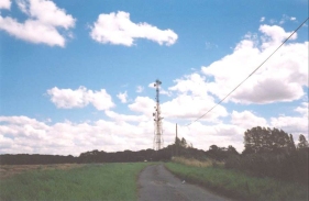
According to the list that I use, Suffolk has the third-from lowest county top, at 128 metres (419 feet). Unfortunately like the Essex and Cambridgeshire tops the highest point is not a significant point but a flat expanse of land, so it is very hard to work out exactly where the top is. I settled for the grid reference that was listed in my tables, which is halfway between Elms Farm and the large radio mast.
Unfortunately the vast majority of this walk involves road walking, which is hardly anyone's idea of fun walking. Unfortunately there were very few paths in the area that led in anything like the right direction, so it was a matter of grinning and bearing it and getting on with the walk.
Suffolk is quite a nice county, despite it being relatively flat. However I must say that it is not the most obvious place for me to have chosen to walk - if there had not been the target of walking to Suffolk's highest point and then onto Bury St Edmunds, I do not think that I would have chosen to do it.
There are a few pubs on the route of this walk, if you should want to call in for refreshment. Unfortunately my hectic timetable did not allow me to call in any of them, and I had to stop at a house near Whepstead to get my two-litre Platypus water bottle filled as I was running out of water in the heat. I had some Lemon Isotar drinks supplement in the bottle, and the householder took one look at the yellow liquid that lay in the bottom of the Platypus and enquired what I had put in the bottle!
Since I set off late due to fears about the weather I had to move fast to catch the train from Bury St Edmunds at 17.24. Due to the miracles of railway timetabling it was the last train back to Newmarket for over three hours, so if I had not caught it then I would have had to investigate the bus / coach options or faced a long wait. I eventually arrived at the station at 17.12, so I had a little over ten minutes to wait for my train.
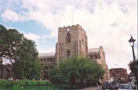
Bury St Edmunds is a lovely town, with much to see in it. Unfortunately due to having to rush for my train, I did not get time to see much of it. This was annoying, but the few sights that I did get as I walked through, of the Cathedral, market and bustling streets, were superb.
Directions
Turn right out of Newmarket station forecourt, and head northeastwards down Paddocks Road. At the junction turn with the B1103 turn right and head under the railway and up New Cheveley Road (the B1103). When you reach the New Wellington public house turn right and head uphill along Duchess Drive.
This road heads uphill, and shortly after you pass Dalham Hall Stud on the right, a road heads off to the left. This road shortly leads to another by a phone box at Cheveley Park. Continue along this road eastwards into Cheveley.
At the T-junction at the end of this road beside a school turn right and then, halfway to the church, take a footpath (part of the Icknield Way) that starts between two houses. It soon becomes a green lane between two hedges. Follow this footpath into the village of Ashley.
At the end of the footpath turn left for a short distance down the B1063 past a shop before turning right to join another road. This road shortly ends at another road. Turn right down this road past the village sign and pond. Continue along this road until you come across a road heading off to the right. Head down this road for a mile towards the village of Dalham.
Before Dalham is reached the road joined the B1085. Turn right onto the road and head downhill past a windmill into the village. Once you have crossed the River Kennett by a bridge follow the road as it swings to the right and take the first road to the left, which heads uphill.
Follow this road for about two kilometres past Leipsic Wood and Jilling's Farm. Shortly after the farm a road to the right heads south for two kilometres to the village of Ousden.
In Ousden take a road to the left and then one to the right beside an old chapel which has been converted to a house. Head south on this road past Witham's Farm and take the first road to the left, heading past Baxter's Green. At the end of this road turn right for a short distance and then take a road to the left opposite a conspicuous water tower.
After about half a kilometre a track leads off past some houses to the right. Head down this track, and take a footpath that heads through some trees. As you pass to the left of a Hall, the footpath goes off to the left across a field and through some trees before meeting up with the A143 road.
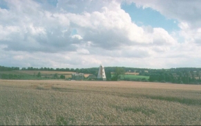
Turn right along the A143 and follow it carefully for a short distance to the south. It is a fairly busy road, so much care is needed. After about a hundred yards a road leads off to the left uphill to Elms Farm. Take this road and follow it as it becomes a track after the farm. Between the Farm and the communications mast is the highest point of Suffolk, although it is hard to exactly visualise where this may be as unfortunately there is no obvious highest point.
At the communications mast the track veers off to the right, and after the bend you immediately need to take a footpath that leads off to the left. This footpath takes you past Great Wood, and then across fields roughly eastwards towards the village of Rede. Near Rede the footpath joins end-on to a track. Follow this track to a road.
Turn right along the road past the church and follow the road as it swings around to the left. At the end of this road turn left and head north-eastwards past Steadman's Farm and Haws Wood. After passing a Pub on the left you need to take the second road to the left, which heads northwards to Harram Bottom.
At Harram Bottom the road joins the B1066. This is not a very busy road, but there are a number of bends that care need to be taken when walking along it. After a couple of miles the road ends at the A143 Bury St Edmunds to Haverhill Road.
Turn right along the A143 using the pavement on the left side of the road. Follow this road for a mile north-eastwards into the centre of Bury St Edmunds. At a roundabout head straight across and head east into the town along Westgate Street.
Head down this road and then turn left, to Follow the signs for the Cathedral. Follow the road past the Cathedral and the market, and shortly after it swings to the right take Northgate Street leading off uphill to the left. Follow this road to another roundabout; cross over this and take the first road to the left, which immediately leads to the railway station.
Distances
| From | To | Distance (m) | Ascent (ft) | Descent (ft) |
|---|---|---|---|---|
| Newmarket station | Suffolk county top | 12.7 | 751 | 456 |
| Suffolk county top | Bury St Edmunds station | 9.0 | 230 | 541 |
This makes a total distance of 21.7 miles, with 981 feet of ascent and 997 feet of descent.
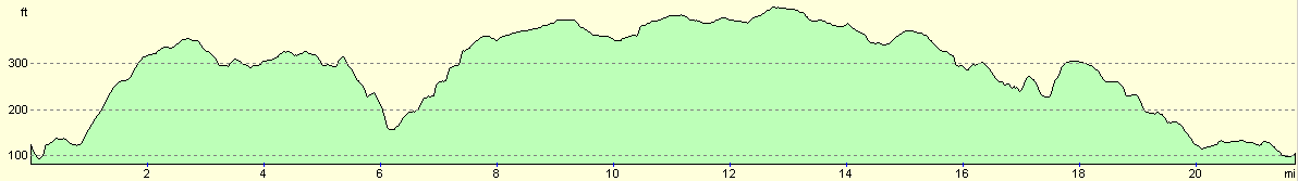
For more information on profiles, ascents and descents, see this page
Transport
Irregular train services run between Bury St Edmunds to Newmarket. Strangely enough there appear to be much more regular services from Newmarket to Bury St Edmunds. See the National Rail Enquiries website for more details.
There are also coach services linking the two towns, which may prove more useful and frequent.
Disclaimer
Please note that I take no responsibility for anything that may happen when following these directions. If you intend to follow this route, then please use the relevant maps and check the route out before you go out. As always when walking, use common sense and you should be fine.
If you find any information on any of these routes that is inaccurate, or you wish to add anything, then please email me.
All images on this site are © of the author. Any reproduction, retransmissions, or republication of all or part of any document found on this site is expressly prohibited, unless the author has explicitly granted its prior written consent to so reproduce, retransmit, or republish the material. All other rights reserved.
Although this site includes links providing convenient direct access to other Internet sites, I do not endorse, approve, certify or make warranties or representations as to the accuracy of the information on these sites.
And finally, enjoy your walking!
This walk was mentioned in the following routes:
| A walk around East Anglia |
Nearby walks
| # | Title | Walk length (miles) |
|---|---|---|
| 7 | Waterbeach - Burwell - Swaffham - Waterbeach | 17.1 |
| 8 | Waterbeach to Newmarket | 17.5 |
| 26 | Waterbeach to Dullingham | 10.7 |
|
|

|