Walk #106: Bury St Edmunds to Stowmarket
 |
 |
|
General Data
| Date Walked | 02/09/2000 |
| County | Suffolk |
| Start Location | Bury St Edmunds |
| End Location | Stowmarket station |
| Start time | 08.25 |
| End time | 13.20 |
| Distance | 15.6 miles |
| Description | This was a quite gentle, flat walk, almost all of which was along roads. |
| Pack | Today I carried full Pennine Way kit, including tent and food. |
| Condition | I feel okay after this walk, and have no real problems, even with my feet. |
| Weather | The forecast had been for heavy showers, so it was with some trepidation that I set out. Fortunately the cloudy skies soon cleared and left a mixture of sunny and cloudy periods. About 45 minutes after I finished the heavens opened and some heavy deluges followed, so I finished at the right time. |
| OS map | Landranger number 155 (Bury St Edmunds, Sudbury & Stowmarket) |
Map of the walk
Maps courtesy of Google Maps. Route for indicative purposes only, and may have been plotted after the walk. Please let me have comments on what you think of this new format. For a detailed table of timings for this walk, please see the table file.
Notes
This was quite a nice day's walk, despite the fact that nearly all of it was road walking. Suffolk is quite a nice county, although today's walk had no hills of any note (indeed, it did not have any climbs or descents worth mentioning).
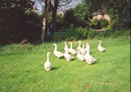
There are some nice villages on this route; in particular Harleston was one that caught my attention, with it's very large and well-maintained village green. I sat on a bench on the green and watched Swallows dive to catch insects; it was a very engrossing sight in the midday sun.
Although this was only a 15 mile walk, my condition at the end was fine, and indeed I considered continuing on along the Gipping River Valley Path for a few miles to the railway station at Needham Market. Fortunately I decided against this, for soon after I finished the forecast rain started to fall with a vengeance. Fortunately by the time it started to rain I had retired to a pub next to the station for half an hour whilst I waited for the train.
The next walk that I have to do (which will probably be tomorrow) is along the Gipping River Valley path from Stowmarket to Ipswich, which should be totally different to today's road walk. It will also very probably be muddy and wet after all the rain that we have had recently.
Once I reached Stowmarket I had to walk through the centre of the town. Whilst I was there I nipped into the local Tourist Information office and got a little guide to the Gipping River Valley Path and a book covering the Angles Way from Thetford to the coast near Lowestoft. This looks like it may be a very interesting walk to do in the future, so I may start some preplanning of it soon.
Directions
Turn right out of Bury St Edmunds station and head south down the main road to a roundabout. Head straight over the roundabout and continue northwards up a small hill and the down the other side. At the bottom of the hill turn left along Mustow Road and follow it as it becomes Eastgate street and heads eastwards under the A14(T).
The road heads up a small hill, and when it starts to bend to the left take Mount road to the right. This road soon ends and becomes a footpath and cycleway. Follow this as it curves around to the east. Cross over a roundabout after Moreton Hall and continue onwards past Battlies Green to a location just south of Thurston Station beside Rougham Park.
Continue over the junction and follow the road for a short distance as it bends to the north-east. At another junction turn right down Beyton Road, to head south-eastwards under the A14(T) and into Beyton. In Beyton continue south-eastwards on the road past Brook Farm and Hessett House. There are several roads in Beyton and it could be easy to confuse them, so you need to take the one at the south-eastern end of the long village green signposted for Drinkstone.
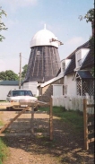
Just after Hessett House the road turns eastwards to pass through Drinkstone and past two abandoned windmills. When the road turns to the left to go into Woolpit take a road that heads straight on eastwards into Woolpit Green. Join another road and follow it into Woolpit Heath.
Continue southeastwards into Borley Green. When the road ends at a T-junction turn right and head south for about 500 metres. A road then leads off to the southeast past Rockylls Hall, and a short distance beyond it to the Shelland village sign. At the sign a track a track leads off to the right. Follow this track, which soon becomes a footpath, southeastwards to a moat and a road at New Farm.
Turn left along the road and head into the lovely little village of Harleston. In the village turn right and head southeastwards through Onehouse. Shortly after the road turns southwards take a road to the left that leads up a short hill past Stowmarket School and towards the centre of Stowmarket. When the road ends take the B1115 for a short distance eastwards through the centre of the town and to the railway station.
Distances
| From | To | Distance (m) | Ascent (ft) | Descent (ft) |
|---|---|---|---|---|
| Bury St Edmunds | Thurston | 5.6 | 200 | 138 |
| Thurston | Woolpit Heath | 4.9 | 174 | 148 |
| Woolpit Heath | Stowmarket | 5.1 | 112 | 213 |
This makes a total distance of 15.6 miles, with 486 feet of ascent and 499 feet of descent.
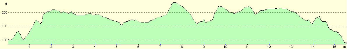
For more information on profiles, ascents and descents, see this page
Transport
There are regular train services from Stowmarket to Bury St Edmunds, with intermediate stations at Elmswell and Thurston. There are also bus services that serve many of the villages on the route.
Disclaimer
Please note that I take no responsibility for anything that may happen when following these directions. If you intend to follow this route, then please use the relevant maps and check the route out before you go out. As always when walking, use common sense and you should be fine.
If you find any information on any of these routes that is inaccurate, or you wish to add anything, then please email me.
All images on this site are © of the author. Any reproduction, retransmissions, or republication of all or part of any document found on this site is expressly prohibited, unless the author has explicitly granted its prior written consent to so reproduce, retransmit, or republish the material. All other rights reserved.
Although this site includes links providing convenient direct access to other Internet sites, I do not endorse, approve, certify or make warranties or representations as to the accuracy of the information on these sites.
And finally, enjoy your walking!
This walk was mentioned in the following routes:
| A walk around East Anglia |
Nearby walks
| # | Title | Walk length (miles) |
|---|---|---|
| 105 | Newmarket to Bury St Edmunds | 21.7 |
| 107 | Stowmarket to Ipswich | 16.1 |
| 212 | Bury St Edmunds to Thetford | 17.8 |
|
|

|