Walk #107: Stowmarket to Ipswich
 |
 |
|
General Data
| Date Walked | 03/09/2000 |
| County | Suffolk |
| Start Location | Stowmarket station |
| End Location | Ipswich Station |
| Start time | 07.30 |
| End time | 13.20 |
| Distance | 16.1 miles |
| Description | This was a lovely riverside walk. |
| Pack | Today I carried minimal kit, with no tent, sleeping bag or spare clothes. |
| Condition | I am okay after this walk; I could have walked much further if necessary, particularly if I had had a rest. |
| Weather | It was overcast all day, with only occasional glimpses of the sun. There was also quite a cold wind, which meant that I kept my coat on all day. It was the first time since April that this had proved necessary, and was a sign that the weather was starting to become Autumnal. At Sproughton there was a five minute shower, but it proved nothing to worry about. |
| OS map | Landranger number 155 (Bury St Edmunds, Sudbury & Stowmarket) and Landranger number 169 (Ipswich & The Naze, Clacton-on-sea) |
 |
Map of the walk
Maps courtesy of Google Maps. Route for indicative purposes only, and may have been plotted after the walk. Please let me have comments on what you think of this new format. For a detailed table of timings for this walk, please see the table file.
Notes
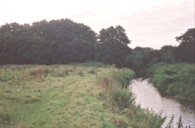
This was a lovely day's walk following the River Gipping south eastwards to Ipswich. The first part of the walk south of Stowmarket is not the best, as the river and path winds it's way between industrial buildings, with some associated smells coming from a large ICI plant.
However further south the walk becomes much better, and in a strange way a stretch just north of Needham Market reminded me of the Pennine Way north of Alston! The path was muddy in places, good in others, and the long grass was wet from the overnight rain. Due to this I made good time, and I soon found myself in Needham Market. Unfortunately the river does not go through the centre of the town and so I did not get to see much of it, but the parts I could see were all very nice. Needham Market does not have a market, as it dies out during the Black Death, but there are some plans to bring back a weekly market to the town. Apparently a problem is that the old market was straight down the High Street, so a new location would have to be found for it to be held.
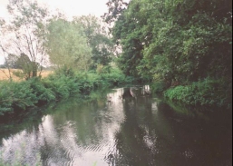
From Needham Market it was a case of following the river south-eastwards as it went through some pleasant countryside. At Bramford I diverted from the canal into the village in order to seek out a pub where I could have some lunch. Unfortunately both of the available pubs did not open until midday, which was still a quarter of an hour away. So I purchased a few refreshments in the village shop and set off again. I decided not to walk back to the canal, but to head into the nearby village of Sproughton, and from there back to the river.
For many people walking the lowlands (and land does not becomes much low or flatter than East Anglia) is a boring, uninteresting concept. For myself, however, it has it's own delights; butterflies dancing in light let through a woodland canopy, kingfisher's flying over a river, and the knowledge that round the next corner there will not be a 200-metre hill to climb. Okay, so it is not very hilly, but it is still a beautiful part of the world.
In 1794 the River Gipping was made navigable to boats as the Ipswich and Stowmarket Navigation. This reached from the Orwell Estuary on the Suffolk Coast to Stowmarket. It had 15 locks rising 90 feet within the 17-mile navigable length. It finally closed in 1922 after trade to two fertiliser factories and an explosives works ceased, and was abandoned 10 years later.
The navigation was first proposed in 1719, but it was not until 1789 that it was seriously considered. William Jessop (who with his son Josias Jessop is a hero of mine) was engaged for the work, who then hired Isaac Lenny as the surveyor.
A group are currently looking at making the river navigable once more, and they have already restored Bosmere Lock near Needham Market, and are currently working on Creeting Lock. For more details of this see the Waterway Recovery Group website. Alternatively look at the IWA website, which contains historical details and photos of the Navigation structures as they are nowadays.
On the 11th of August 1871 there were two explosions at Prentice's Gun Cotton factory in Stowmarket which killed twenty-eight people; some people who ran to the scene of the first explosion were killed by the second explosion.
The population of Stowmarket is currently about 14,000, making it a reasonably large town. Employment is currently dominated by the factories that line (and themselves dominate) the early stages of the River Gipping as it heads towards the sea, although I doubt that the river plays such an important part in the town's industry as it used to.
Ipswich is not exactly my favourite town, but I know of people who are quite fond of it. It is slightly too industrialised for my liking, and suffers from having been a port but not having a seafront (the sea being reached by the River Orwell). It first became prosperous due to the woollen industry, and later on it became an important port. It is also the oldest continuously inhabited Anglo-Saxon town in Britain, so it is of some importance to historians.
Directions
Head out of the station entrance in Stowmarket. Much of this walk follows the Gipping Valley River Path, although I divert off it in several places. Head down the road from the station, straight ahead across the car park. After a very short distance you pass a pub (which used to be a maltings) and a bridge; turn left between the pub and the bridge and descend by some steps down to the river.
Follow the river as it heads southwards, initially between industrial buildings belonging to ICI. Smell becomes the predominant sense on this section, as the factory is slightly odorous. It did, however, have a nice concrete manhole cover on which I could sit to change out of my trainers and into my boots. ;-)
The factories are soon left behind, and the walk becomes increasingly rural and secluded as the river winds it's way south-eastwards towards Needham Market. After Needham Market the path and river approaches close to the A14, and shortly after this the path leaves the river for a short period and follows beside the railway line for about half a kilometre. Near Baylham House Mill a road is reached, and it is followed back to the river at the Mill.
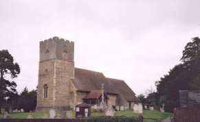
The path then follows the western bank of the river past some old disused sand pits, now flooded and apparently heavily used by anglers. After this the river approaches Great Blakenham. Here I left the river near the church and joined the B1113 road. Turn left down the road, and after a short distance take a road that leads off to the left, over a railway crossing and back to the river, just before the road dives under the A14.
The path then follows the western bank of the river south to a railway bridge near a large factory. At the bridge the path crosses over to the eastern side of the river and follows it alongside some nice meadows into the village of Bramford. At the southern end of Bramford the B1067 is reached. Turn right down this road (Ship Lane) to head into Bramford, where there are shops and a couple of pubs.
When the B1067 turns sharply to the right turn left up a minor road (Vicarage Lane). A footpath leads from near the junction diagonally over a field to the B1113. Turn to the left along the B113 and use the pavement to get into Sproughton. Turn left along the first road you reach in Sproughton (Lower Street) to head back down a hill to the river beside Sproughton Church.
The path now follows the eastern bank as the river swings around and starts heading into Ipswich. It passes under two railway lines as the area becomes increasingly industrialised and curves around to the south. When the path meets parallels a main road join the road (West End Road) and follow this as it swings around to the east. Cross over the River Orwell by a bridge and the forecourt to Ipswich Station is straight ahead across Burrell Road.
Transport
There are regular train services from Ipswich to Stowmarket. There is an intermediate station at Needham Market, and there are also bus services that serve villages on the route.
Distances
| From | To | Distance (m) | Ascent (ft) | Descent (ft) |
|---|---|---|---|---|
| Stowmarket station | Great Blakenham | 8.5 | 108 | 151 |
| Great Blakenham | Ipswich station | 7.6 | 115 | 154 |
This makes a total distance of 16.1 miles, with 223 feet of ascent and 305 feet of descent.
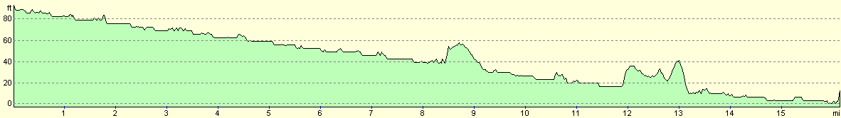
For more information on profiles, ascents and descents, see this page
Disclaimer
Please note that I take no responsibility for anything that may happen when following these directions. If you intend to follow this route, then please use the relevant maps and check the route out before you go out. As always when walking, use common sense and you should be fine.
If you find any information on any of these routes that is inaccurate, or you wish to add anything, then please email me.
All images on this site are © of the author. Any reproduction, retransmissions, or republication of all or part of any document found on this site is expressly prohibited, unless the author has explicitly granted its prior written consent to so reproduce, retransmit, or republish the material. All other rights reserved.
Although this site includes links providing convenient direct access to other Internet sites, I do not endorse, approve, certify or make warranties or representations as to the accuracy of the information on these sites.
And finally, enjoy your walking!
This walk was mentioned in the following routes:
| A walk around East Anglia |
Nearby walks
| # | Title | Walk length (miles) |
|---|---|---|
| 106 | Bury St Edmunds to Stowmarket | 15.6 |
| 131 | Ipswich to Wickham Market Station | 16.7 |
| 264 | Waldringfield to Nacton via Felixstowe | 19.6 |
|
|

|