Walk #110: Morebattle to Ancrum
 |
 |
|
General Data
| Date Walked | 15/09/2000 |
| County | Borders |
| Start Location | Morebattle |
| End Location | Ancrum |
| Start time | 09.45 |
| End time | 15.15 |
| Distance | 13.6 miles |
| Description | This was a nice walk following St Cuthbert's Way, including a long section of old Roman Road northeastwards from Crailinghall. |
| Pack | Today I carried full Pennine Way kit. |
| Condition | I feel generally okay after this walk. My left leg has been sore all day, and was stiff for the first three miles or so. My feet are okay, with no blisters of any consequence to report. I have had no trouble with my back or shoulders, and the cramp that I had last night in my left leg has not recurred, but has left the soreness mentioned above. |
| Weather | In a word, wet. It was the annoying sort of rain that was a light drizzle that lasted for most of the day. My waterproofs kept me mostly dry, and I walked with the hood of my coat down as I was getting very hot with it up. There was in total about five minutes worth of sun during the day, and provably about one hour at the end when it stopped drizzling. After I finished the weather became dryer, allowing me to take my time in putting up my tent and cook outside. Unfortunately the weather forecast says that tomorrow will be very wet. |
| OS map | Landranger number 74 (Kelso & Coldstream, Jedburgh & Duns) |
 |
Map of the walk
Maps courtesy of Google Maps. Route for indicative purposes only, and may have been plotted after the walk. Please let me have comments on what you think of this new format. For a detailed table of timings for this walk, please see the table file.
Notes
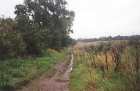
This was a lovely walk that was spoiled by the wet weather. There are no major climbs on this section, just many little up's and down's that can be quite tiring. The whole route was very muddy when I got off of the road sections, and this did not help me to keep my feet dry. The old Roman Road, Dere Street, that I followed from Crailinghall was (as is common with Roman Roads) very up-and-down, fully muddy and in places very stony. In one place, on a descent southeast of the A698, the path was quite a large stream, stony and muddy at the same time!
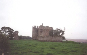
The highlight of the day was definitely Cessford Castle, which although ruined is quite an arresting sight, and exudes the power that it must have had over the local area. It is in quite a prominent location, and is visible or a fair few miles around.
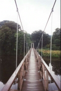
I had a potentially nasty incident when crossing the spectacular bridge over the River Teviot. It was a suspension bridge that was completed in 1999, replacing the previous bridge that had survived for about five years before being destroyed by floods in 1997. I had crossed the bridge and was descending down the ramp on the northern end when my feet slipped from under me and I ended up sitting on my posterior. I sat there for a couple of minutes, waiting to see if I had hurt any part of myself, as I had hit the wooden decking with quite a thump. Fortunately I was okay, with only my pride wounded, so I strode on regardless.
The campsite here at Lilliardsedge is very nice, with a well-stocked bar and some reasonable food available. The ground is totally sodden and the area outside the entrance porch to my tent rapidly became muddy. My gear was not wet, but after one-and-a-half days walking was damp and smelly with sweat, so I used the facilities available at the campsite to wash and dry them.
I have eaten a lot this evening - at 17.00 I had some rice and at 19.00 I had a burger with chips and some garlic mushrooms washed down with a couple of pints. I did this because I will not bother making myself any breakfast in the morning, and therefore I decided to fill myself up whilst I could.
During the latter part of today the Waterloo Monument on Peniel Heugh was prominently visible. I saw this yesterday whilst climbing Wideopen Hill, and it was nice to be able to see it get nearer and nearer as the day progressed. At the end of tomorrow I shall be climbing the Eildon Hills, which were visible from the same place yesterday on the horizon and seemed a long distance away. Hopefully (although I somehow doubt it) the weather shall be such that I can have just as good a view tomorrow back the way that I have come.
I also met a lovely father and daughter from this part of Scotland who were walking St Cuthbert's Way in the opposite direction. They were very friendly and I consumed a couple of pints with them in the bar until quite late in the night. It is so nice to meet fellow walkers, especially swapping all the tales of the trail which we all collect over the years.
Directions
This walk follows St Cuthbert's Way, and for a much more detailed discussion of the walk and of the features on the route, please see the excellent "St Cuthbert's Way Official Trail Guide", by Roger Smith and Ron Shaw, published by the Stationery Office, ISBN 0 11 495762 2. Although I used the OS maps to navigate by, this book gave me many ideas of what to look for on the walk.
Head from the accommodation (in my case Morebattle Tofts) back to the centre of Morebattle. Follow B6436 road to the west through the village and down the hill onto the floodplain of Kale Water.
Just after you have passed the entrance to Cowbag Farm on the right a road leads off uphill to the left. Follow this road past Otterburn Farm and on for a couple of miles along a winding road to the village of Cessford. On the way you can see Cessford Castle growing in the distance as you approach it, and finally skirt it just before descending a small hill into Cessford.
Turn right to cross a stream and then take a track that leads straight on between the ends of two rows of houses. This track leads westwards and the northwestwards past Castle Knowe before bending to the left and heading to the southwest across Cessford Moor. St Cuthberts Way is very well signposted across this route, and it heads through Cragsheill Wood. Once it has exited the Wood it turns to the right and skirts the edge of the wood along what was for me a muddy path. The wood ends at a track, which the Way turns to the left down. This path heads downhill into Crailinghall.
When you meet a road in Crailinghall turn left and head southwards across a crossroads to a bridge over a stream. Just after the bridge St Cuthberts Way heads off to the right along Dere Street, an old Roman Road whose route we shall be following for the rest of the day.
Dere Street heads up and down hill in a dead-straight line for a few miles, crossing two minor roads. You can turn to the left down either of these roads to reach the town of Jedburgh, which has plenty of accommodation and shops if necessary. The first of the two roads is the more direct and easier route of the two. Dere Street continues on before meeting a minor road that leads almost immediately onto the A698 road. This section of Deere Street was very muddy in places, with the path becoming a stream in places. It was also very stoney in places, and I had to be cautious so that I did not slip on the west stones on the descents.
Cross the A698 and then turn left to cross a river by the road bridge. As soon as you reach the other (western) side of the bridge turn right and head down a long flight of wooden steps to the river.
Follow the western side of the River Teviot for nearly a mile across some good paths until a suspension bridge is reached which allows you to cross the River Teviot. Cross the suspension bridge and head north through the grounds of Monteviot House until you reach the B6400 road. If you reach the road opposite the drive for a house called Woodside then you have gone wrong; head back southwards into the park and turn right to rejoin St Cuthberts Way through the woods.
Cross the B6400 and follow St Cuthberts Way through some pretty woods until Dere Street is reached again, heading to the south-northwest. Deere Street crosses a minor road when the woods ends and then heads across some pretty fields for about a mile, passing Harrietsfield Farm in the process. Shortly after the farm a gate can lead you across fields to the A68(T). This route across two fields is not a right of way, but I found it an easy way to access the A68(T), and indeed I discovered that two other walkers also used it for the same reason. Lilliardsedge Park caravan and camping park is to the right along the A68(T).
Distances
| From | To | Distance (m) | Ascent (ft) | Descent (ft) |
|---|---|---|---|---|
| Morebattle Tofts | Crailinghall | 6.6 | 564 | 492 |
| Crailinghall | A698 | 3.2 | 351 | 509 |
| A698 | Lilliardsedge Park | 3.8 | 433 | 148 |
This makes a total distance of 13.6 miles, with 1348 feet of ascent and 1149 feet of descent.
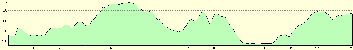
For more information on profiles, ascents and descents, see this page
Accommodation
I spent the night at Lilliardsedge Park Caravan and campsite, a fairly well appointed site that had a bar and provided some reasonable but not exceptional evening meals.
Disclaimer
Please note that I take no responsibility for anything that may happen when following these directions. If you intend to follow this route, then please use the relevant maps and check the route out before you go out. As always when walking, use common sense and you should be fine.
If you find any information on any of these routes that is inaccurate, or you wish to add anything, then please email me.
All images on this site are © of the author. Any reproduction, retransmissions, or republication of all or part of any document found on this site is expressly prohibited, unless the author has explicitly granted its prior written consent to so reproduce, retransmit, or republish the material. All other rights reserved.
Although this site includes links providing convenient direct access to other Internet sites, I do not endorse, approve, certify or make warranties or representations as to the accuracy of the information on these sites.
And finally, enjoy your walking!
This walk was mentioned in the following routes:
| My sectional Land's End to John O'Groats walk |
Nearby walks
| # | Title | Walk length (miles) |
|---|---|---|
| 48 | 18-mile bothy to Kirk Yetholm | 7.2 |
| 109 | Kirk Yetholm to Morebattle | 6.7 |
|
|

|