Walk #109: Kirk Yetholm to Morebattle
 |
 |
|
General Data
| Date Walked | 14/09/2000 |
| County | Borders |
| Start Location | Kirk Yetholm |
| End Location | Morebattle |
| Start time | 15.30 |
| End time | 18.30 |
| Distance | 6.7 miles |
| Description | This was a nice and not too strenuous walk over the hills from Kirk Yetholm to Morebattle. |
| Pack | Today I carried full Pennine Way kit. |
| Condition | I feel okay after this walk, but this is to be expected after just seven miles of not too strenuous walking. When I got to the B&B I was taking my boots off in the doorway and I got a severe cramp in my left leg - something that I have rarely (if ever) have suffered from before. I place most of the blame for this on the fact that I was cooped up on a train for most of the day. Otherwise everything is fine. |
| Weather | Cloud, sometimes heavy with one heavy rainstorm on the ascent to Wideopen Hill. The wetness was more than offset however by the rainbow that was left in the rain's wake. There was also quite a chilly wind, particularly on the exposed sections of the walk. |
| OS map | Landranger number 74 (Kelso & Coldstream, Jedburgh & Duns) |
Map of the walk
Maps courtesy of Google Maps. Route for indicative purposes only, and may have been plotted after the walk. Please let me have comments on what you think of this new format. For a detailed table of timings for this walk, please see the table file.
Notes
I arrived at Kirk Yetholm at 15.00, and in a moment of madness I decided to walk the seven miles to Morebattle rather than stay in Kirk Yetholm overnight and do the seventeen miles tomorrow. So I booked myself a room at the Morebattle Tofts B&B and set off to do the walk.
Being back in Kirk Yetholm bought back many memories of doing the Pennine Way last year - I looked in the book that you sign when you finish the Way and saw my entry, and also noted that the Holmes family that I had met finished the walk later the same day. Whilst I was sipping my pint in the Border Inn I wrote the following:
'Sitting in the Border Hotel at Kirk Yetholm I am full of trepidation and joy, trepidation at the thought of having to walk for nine days with my heavy pack, but joy at the knowledge that I successfully walked the Pennine Way last year. I feel like crying - the emotion is heavy within me. Will I ever get to John O'Groats - after all, this is the very place where I first got the idea of doing this mad adventure. All of Scotland awaits, and I cannot wait. I want all my senses to be overwhelmed, to be able to take back more memories from this trip than any man should have any right to have. Above all I want to live, and to be able to experience all that life has to offer.'
This B&B is marvellous - the Playfair family who own it also own a great deal of the land hereabouts, and in the lounge there is a book containing a detailed history of the family. The evening meal was also great, and since it was cooked by a Hungarian lady it had some Hungarian recipes - a starter of fish paste served in a hollowed-out Lemon, a Pork main course followed by bread and butter pudding.
I am slightly worried by the fact that I got a severe cramp in my left lag at the end of today's walk. I have a relatively easy ten or eleven mile walk to do tomorrow, so I shall take my time on it and see what develops.
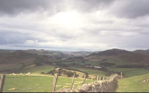
The views from the top of Wideopen Hill are very expansive - to the east is Kirk Yetholm and the Cheviots, and to the west can be seen the Waterloo Monument (near the campsite where I shall be spending tomorrow night) and the Eildon hills near Melrose at the end of St Cuthberts Way. I am looking forward to the next couple of day's walking across the plains between the Cheviot and Eildon Hills, including sections along the Tweed. I just hope that it does not rain - the forecast for Scotland says that the weather tomorrow is going to be bright with showers, but torrential rain is forecast for England.
Directions
This walk follows St Cuthberts Way southwestwards from Kirk Yetholm over some of the foothills of the Cheviot Hills to the little village of Morebattle. For a much more detailed discussion of the walk and of the features on the route, please see the excellent "St Cuthbert's Way Official Trail Guide", by Roger Smith and Ron Shaw, published by the Stationery Office, ISBN 0 11 495762 2. Although I used the OS maps to navigate by, this book gave me many ideas of what to look for on the walk.
Kirk Yetholm is well known as being the northern end-point of the Pennine Way, the place many people dream of during two or three weeks of trudging northwards. Nestling gently amongst the northern foothills of the Cheviots, it is also almost the mid-point of St Cuthberts Way from Holy Island to Melrose. This is a very well signposted walk, and this means that it is quite hard to get lost as long as you keep looking for the way markers.
From the Border Hotel in Kirk Yetholm head east along the road past the green. Take the first road to the right to head north through the village alongside another edge of the green. Pass the Scottish Youth Hostel Association building, and a little bridge before heading across fields to meet the road bridge over Bowmont Water linking Kirk Yetholm with Town Yetholm.
Turn right to cross the bridge and once on the other side of Bowmont Water turn left and descend to the fields. Skirt the river across fields before a track is met that brings you out onto a minor road. Turn right down this road, and almost immediately you reach the 6401 road.
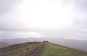
Turn left down the B6401 and head along it for about 750 metres to a road junction. Turn left down the road through Primsidehill and head south along this road for just over a kilometre. Take a track then leads sharply uphill to the right for a short distance before heading over a stile to the left and uphill across other stiles to the southwest to the summit of Crookedshaws Hill. Follow a stone wall over these hills until you reach the summit of Wideopen Hill, at 368 metres the highest point of St Cuthberts Way (although if you climb either of the Eildon Hills then this will be beaten).
Follow the wall as it descends to Grubbit Law, and then head downhill across tough grassland to a farm and a bridge over Kale Water. It is important not to follow the stone wall for too far, as it is easy to follow an obvious track that heads northwestwards towards Morebattle but which is not St Cuthberts Way. This is unfortunately what I did, but fortunately it was easy to recover as a track leads back to the Way.
Cross Kale Water and join a minor road. Turn right to head north down this road for a short distance until you reach a junction with another road. Turn left up this road and follow it as it heads over a little hill before descending down again to join the B6436. Follow the road straight on into the village of Morebattle. Before the church a footpath leads down to the right and to a little bridge over Kale Water. The B&B that I stayed in, Morebattle Tofts is to the left on the other side of the bridge.
Distances
| From | To | Distance (m) | Ascent (ft) | Descent (ft) |
|---|---|---|---|---|
| Kirk Yetholm | Wideopen Hill | 3.6 | 843 | 112 |
| Wideopen Hill | Morebattle Tofts | 3.1 | 331 | 1175 |
This makes a total distance of 6.7 miles, with 1174 feet of ascent and 1287 feet of descent.
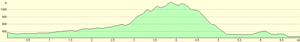
For more information on profiles, ascents and descents, see this page
Accommodation
I stayed at Morebattle Tofts B&B, which is located just to the north of the village of Morebattle off the B6436. The telephone number is (01573) 440364. This B&B served up a very generous and filling evening meal for a little extra money, and made me feel very welcoming. All in all one of the better establishments that I have stayed in.
Transport
There are fairly regular bus services from Kelso to Kirk Yetholm during the week. This service is run by a firm that is available on (01573) 224141. There are also some bus services from Kelso to Morebattle.
You can get to Kelso from either Berwick-upon-Tweed or Edinburgh, both of which have main line railway stations. The busses from Berwick-upon-Tweed are operated by Swan busses, and are contactable on (01289) 306436. The busses from Edinburgh take two hours, almost double the time of the ones from Berwick, and are operated by Munros busses, who are contactable on (01835) 862253.
Disclaimer
Please note that I take no responsibility for anything that may happen when following these directions. If you intend to follow this route, then please use the relevant maps and check the route out before you go out. As always when walking, use common sense and you should be fine.
If you find any information on any of these routes that is inaccurate, or you wish to add anything, then please email me.
All images on this site are © of the author. Any reproduction, retransmissions, or republication of all or part of any document found on this site is expressly prohibited, unless the author has explicitly granted its prior written consent to so reproduce, retransmit, or republish the material. All other rights reserved.
Although this site includes links providing convenient direct access to other Internet sites, I do not endorse, approve, certify or make warranties or representations as to the accuracy of the information on these sites.
And finally, enjoy your walking!
This walk was mentioned in the following routes:
| My sectional Land's End to John O'Groats walk |
Nearby walks
| # | Title | Walk length (miles) |
|---|---|---|
| 47 | Byrness to 18-mile bothy | 18.1 |
| 48 | 18-mile bothy to Kirk Yetholm | 7.2 |
|
|

|