Walk #108: Waterbeach to Huntingdon
 |
 |
|
General Data
| Date Walked | 09/09/2000 |
| County | Cambridgeshire |
| Start Location | Waterbeach |
| End Location | Huntingdon |
| Start time | 07.15 |
| End time | 16.10 |
| Distance | 21.6 miles |
| Description | This was a naughty but quite exhilarating walk along roads, footpaths, disused railways and the River Ouse. |
| Pack | Today I carried full Pennine Way kit. |
| Condition | I have a couple of hot-spots on my heels which were causing me slight discomfort during the latter stages of the walk. I also have a few bramble cuts on my left arm. Apart from these, everything is fine. |
| Weather | The weather today was quite warm, and even though I started off at a little past seven in the morning I wore only a base layer. It became quite hot later on in the day, although there was some cloud in the sky and a little wind to cool me off. There was absolutely no sign of any rain. |
| OS map | Landranger number 154 (Cambridge & Newmarket, Saffron Walden) and Landranger number 153 (Bedford & Huntingdon, St Neots & Biggleswade) |
 |
Map of the walk
Maps courtesy of Google Maps. Route for indicative purposes only, and may have been plotted after the walk. Please let me have comments on what you think of this new format. For a detailed table of timings for this walk, please see the table file.
Notes
Note in 2010: The old railway line between Cambridge and St Ives has now been converted into a guided busway. This may make this walk impossible to follow.
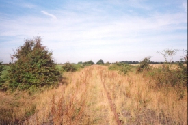
This could very well have been quite a boring walk, with large sections of road walking needed to get from Waterbeach to St Ives, where the Ouse Valley Way can be picked up. Fortunately there is a disused railway that runs all the way from Cambridge to near St Ives, and this provided a direct route for a large section of the journey. Although technically this is trespassing, the entire route was overgrown (in some places almost impassably so), so the changes of being hit by a train are rather remote.
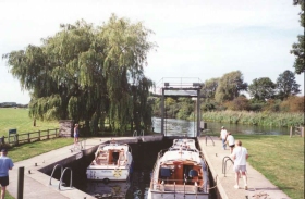
St Ives is a wonderful little town, and one that I am going to have to explore more thoroughly in the future. I stopped at the Royal Oak pub in the town and had a pint and a meal, which was quite relaxing and allowed me to recover some energy ready for the final part of the trip.
Yet again I proved to have more than adequate energy reserves for the walk, and I did not need to stop for the first three hours, despite the going along he railway line being very heavy in places. Unfortunately as usual my feet gave me the most trouble, and as I was using me X-Adventure 7's this was probably to be expected.
The part of the route that was along the disused railway line was incredibly overgrown in places with brambles, trees and other vegetation. The downside of this was that it seemed like a jungle adventure for some stages, and I ended up getting some bramble cuts on my left arm, but on the upside this was a highly enjoyable section of the walk, and I could pause every now and then to eat blackberries off the brambles that were attacking me.
Another high point of the day was seeing five Spitfire planes fly over when I was walking along the railway line near Longstanton. The nearby museum at Duxford was hosting a celebration of the plane as part of the sixtieth anniversary of the Battle of Britain, and these were flying as part of the celebration. It was an amazing sight, and the sound of the Merlin engines were unmistakable.
I am off to Scotland on Thursday so that I can start the section of my Land's End to John O'Groats walk north of Kirk Yetholm. This walk, along with the two that I did last weekend, has convinced me that I am more than ready for this walk.
Directions
This walk starts off from my flat in Waterbeach; since this is slightly out from the centre of the village it is probably not the most obvious place to start. If you wish to start from the village centre, then please ignore this first paragraph. Head west along Bannold road, away from Bottisham Lock and the river, and at a white house turn left down Way Lane. Follow Way Lane all the way to the village green. Cross the village green to the right until you meet a road near a bottle bank.
Head west from the centre of the village. When the pavement ends turn right along Car Dyke road and follow it as it curves around to meet the A10. Cross over the A10 and head west up Waterbeach road. Continue on for about a kilometre, and when the road ends at a T-junction near Landbeach village Hall turn right up green End Road to head north out of the village. When you have left the village take the first road to the left, that heads north-westwards to the village of Cottenham.
As the road bends to the left after entering Cottenham, follow it as it becomes Denmark Road. By The Chequers public house (and near the war memorial) turn left down High Street, and then right past the Village Green towards Rampton up Rampton Road.
Rampton Road heads down a small hill and onto Little North Fen. After about a kilometre a bridge over Cottenham Lode is reached. Cross this bridge and take a footpath that leads to the left along the banking of the Lode. Follow the Lode for just over a kilometre, and after a sharp left-hand bend take a footpath that heads over a stile and across a field to a track and bridleway. Turn right up the bridleway for a few hundred metres, and then turn left over another track and bridleway for about 750 metres. The track then reaches the disused Cambridge to St Ives railway line at a level crossing.
At the level crossing turn right and head along the railway line. Technically this is trespassing, as the line is still down and the railway line is not officially a footpath. However, the chance of being hit by a train are non-existent, as in places the line is so overgrown you cannot see the track and actually getting through the vegetation is a chore.
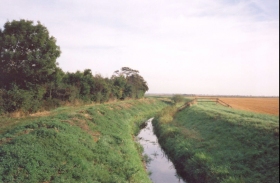
Follow the line as it heads north-westwards and then westwards for nearly three and a half miles, to the level crossing at Church End, between Swavesey and Over. Follow the line westwards from here over two more level crossing taking tracks over the line; at the second (at GR 355695) the track finally became impassable due to vegetation, so I turned off to the right down the track. The track soon turns sharply to the left, and after about two hundred metres ends at a gate. Just before the gate a footpath leads off over a stile to the north, between a lake and a drainage ditch. Follow the path, and cross over the ditch by a bridge before continuing on the other bank. At the end of the path is the River Ouse, so turn left and follow the river upstream.
The path leaves the river for a short while, and ends at a track. Turn right up the track to meet the river again, and then head left alongside the river. The river soon meets a railway bridge over the Ouse - the old Cambridge to St Ives line again, although there is no longer any track left on this section. Cross under the bridge, and turn left to enter the field. Pass alongside the bridge to the far edge of the field, where access can be made to the top of the bridge.
At the top of the bridge there is a track. Turn left to follow this track over the bridge. This is not actually a right-of-way and heads into a quarry site, so I would not recommend anyone to take this route. After the river has been crossed continue on and take another track that leads off to the right into the works. This track soon ends at a T-junction with another road, which carries the Ouse Valley Way. Turn left down the road for about seven hundred metres to a roundabout on the outskirts of St Ives.
Cross over the roundabout and pass a car park on your Left. Take the first road to your left after the car park and head down to the main shopping street in St Ives. Turn right and pass the church and continue along the road. The road meets the river again, and shortly afterwards bends to the right beside another church. Head through the church's grounds and join another path on the other side. This then passes westwards (yet again along the old railway line, now a path) through a wood and past Houghton Grange.
The path continues past the Grange and into the village of Houghton. On the outskirts of a village take a track that leads for a short distance to the left, and then right along a path the passes behind the houses. At a campsite the track passes to the left across the site and onto Houghton Mill.
Pass over the bridges at the Mill onto the southern bank of the Ouse. Turn right past the lock and follow the river. Cross over a bridge over a tributary and cut straight across to another bridge over the same tributary. From here follow the southern bank of the Ouse for about seven hundred metres. The path then bends southwards as a tributary of the Ouse is reached. Follow this river southwards past some lakes until the old St Ives to Huntingdon railway track bed is reached again.
Turn right along the railway track bed for a short distance and then leave it to the left, heading towards the A14. Pass under the A14 by an underpass and head into the outskirts of Godmanchester. The path skirts between a cricket ground and a new housing estate, and a shortcut can be made through the housing state by turning right at the cricket ground and following the roads through the estate to the B1044.
Turn right down the B1044 and pass under the A14. cross the pedestrian bridge over the River Ouse beside the narrow road bridge and at the end of the road turn left to join the ring road. Huntingdon bus station is a little way along the ring road on the right.
Transport
There are regular bus services from Huntingdon bus station to Drummer Street bus station in the centre of Cambridge. It is then either a case of walking to the train station and catching a train to Waterbeach or catching a bus from Drummer Street. The busses from Huntingdon to Waterbeach also call at several of the villages en route, especially St Ives.
Distances
| From | To | Distance (m) | Ascent (ft) | Descent (ft) |
|---|---|---|---|---|
| Waterbeach | Cottenham | 4.6 | 43 | 23 |
| Cottenham | Church End, Over | 6.2 | 62 | 75 |
| Church End, Over | St Ives | 4.3 | 26 | 36 |
| St Ives | Huntingdon | 6.5 | 125 | 95 |
This makes a total distance of 21.6 miles, with 256 feet of ascent and 229 feet of descent.

For more information on profiles, ascents and descents, see this page
Disclaimer
Please note that I take no responsibility for anything that may happen when following these directions. If you intend to follow this route, then please use the relevant maps and check the route out before you go out. As always when walking, use common sense and you should be fine.
If you find any information on any of these routes that is inaccurate, or you wish to add anything, then please email me.
All images on this site are © of the author. Any reproduction, retransmissions, or republication of all or part of any document found on this site is expressly prohibited, unless the author has explicitly granted its prior written consent to so reproduce, retransmit, or republish the material. All other rights reserved.
Although this site includes links providing convenient direct access to other Internet sites, I do not endorse, approve, certify or make warranties or representations as to the accuracy of the information on these sites.
And finally, enjoy your walking!
Nearby walks
| # | Title | Walk length (miles) |
|---|---|---|
| 2 | Waterbeach to Newmarket Road, Cambridge | 5.4 |
| 5 | A short walk around Waterbeach to Car Dyke | 3.0 |
| 6 | Waterbeach to Newmarket Road, Cambridge | 5.4 |
|
|

|