Walk #47: Byrness to 18-mile bothy
 |
General Data
| Date Walked | 25/08/1999 |
| County | Northumberland, Borders |
| Start Location | Byrness |
| End Location | 18-mile bothy |
| Start time | 07.50 |
| End time | 16.20 |
| Distance | 18.1 miles |
| Description | This should have been a highly pleasant stroll across the Cheviots; it was let down by the low cloud layer. |
| Pack | Today I carried full camping gear. |
| Condition | My ankle and legs are fine, my back is fine and generally I am not as fatigued as I was yesterday. I am, however, wet, and so I have towelled myself off, dressed myself in some warm clothing and snuggled up into my sleeping bag. |
| Weather | Today was a wet day, as I spent much of it in the cloud layer as I headed north. |
| OS map | Outdoor Leisure number 16 (The Cheviot Hills) |
Map of the walk
Maps courtesy of Google Maps. Route for indicative purposes only, and may have been plotted after the walk. Please let me have comments on what you think of this new format. For a detailed table of timings for this walk, please see the table file.
Notes
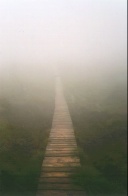
Oh wonderful bothy, the place of my dreams. Though the wind may be blowing outside, you keep me warm inside...
Okay, poetry has never been my strong point, but I can honestly say that I have rarely been as happy to see a building as I was when I saw this bothy emerge through the mist after cheating and guiding myself to it using my GPS. The weather outside is terrible, and if for some reason I had not found this bothy where I was expecting it, today may have been a very different story for me. It probably would not have been a mountain rescue one, but I would have been extremely unhappy. Whoever claims that GPS are unnecessary on the hills will not get a vote from me...
The weather today was truly awful. When I left the YYA it was spitting slightly and there were low clouds over the hills. Once onto the hills I was walking through clouds with a very strong wind coming from my right, meaning that the right hand side of my body was getting wet. Nothing too disastrous though.
After my 35 minute lunch break at the 9-mile bothy the weather really closed in, with periods of driving rain and very low visibility (about ten feet at times). Ended up with the entire lower half of my body getting soaked, including both my feet as my boots slowly filled up with water.
Now it is simply a case of keeping myself warm through the night and not getting chilled. Later on I will make myself some food to warm myself and the bothy up a smidgen.
Directions
I am not going to bother giving any directions for any of the stages of the Pennine Way; there are many route descriptions produced that will better anything that I could produce. The main guides I used were the OS National Trail Guides, which come complete with strip maps of the route. Click on one of the links below to go to the Amazon page for each guide.
|
| 
|
| |
| |
Distances
| From | To | Distance (m) | Ascent (ft) | Descent (ft) |
|---|---|---|---|---|
| Byrness YHA | Chew Green Roman Camp | 5.1 | 1201 | 640 |
| Chew Green Roman Camp | Lamb Hill | 4.1 | 722 | 358 |
| Lamb Hill | 18-mile Bothy | 8.9 | 1706 | 1808 |
This makes a total distance of 18.1 miles, with 3629 feet of ascent and 2806 feet of descent.
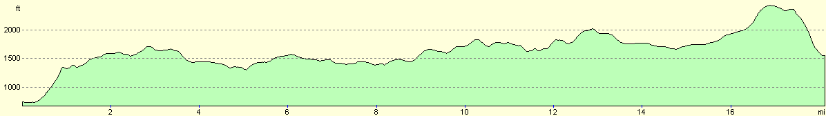
For more information on profiles, ascents and descents, see this page
Disclaimer
Please note that I take no responsibility for anything that may happen when following these directions. If you intend to follow this route, then please use the relevant maps and check the route out before you go out. As always when walking, use common sense and you should be fine.
If you find any information on any of these routes that is inaccurate, or you wish to add anything, then please email me.
All images on this site are © of the author. Any reproduction, retransmissions, or republication of all or part of any document found on this site is expressly prohibited, unless the author has explicitly granted its prior written consent to so reproduce, retransmit, or republish the material. All other rights reserved.
Although this site includes links providing convenient direct access to other Internet sites, I do not endorse, approve, certify or make warranties or representations as to the accuracy of the information on these sites.
And finally, enjoy your walking!
This walk was mentioned in the following routes:
| My sectional Land's End to John O'Groats walk |
| My Pennine Way Walk, 07th to 26th August 1999 |
Nearby walks
| # | Title | Walk length (miles) |
|---|---|---|
| 46 | Bellingham to Byrness | 14.7 |
| 48 | 18-mile bothy to Kirk Yetholm | 7.2 |
|
|

|