Walk #212: Bury St Edmunds to Thetford
 |
 |
|
General Data
| Date Walked | 16/08/2002 |
| County | Suffolk, Norfolk |
| Start Location | Bury St Edmunds |
| End Location | Thetford Station |
| Start time | 07.39 |
| End time | 14.22 |
| Distance | 17.8 miles |
| Description | This was a lovely walk which was in two main halves; a first half following the River Lark and a second through the King's Forest and other parts of Thetford Forest. |
| Pack | I carried my 30-litre Karrimor Hotrock rucksack which had three litres of water, my coats and waterproof trousers in it along with the usual odds and ends. |
| Condition | I feel fine after this walk. My legs were ever so slightly stiff towards the end, but aside from that nothing else hurts. Indeed, I could have walked further; when I got back to Cambridge I walked from the station into town. It was a very hot day, but when I was out of the shade I wore my hat and I took three litres of water with me to drink, so I did not suffer any ill consequences from the heat. |
| Weather | The weather today was fairly hot, probably in the high twenties. There was very little cloud in the sky first thing, but as the day went on it slowly started to cloud over. There was not very much wind to help cool me down, but it did not bother me too much. |
| OS map | Landranger number 155 (Bury St Edmunds, Sudbury & Stowmarket) and Landranger number 144 (Thetford & Diss, Breckland & Wymondham) |
 |
 |
|
 |
 |
|
Map of the walk
Maps courtesy of Google Maps. Route for indicative purposes only, and may have been plotted after the walk. Please let me have comments on what you think of this new format. For a detailed table of timings for this walk, please see the table file.
 |
 |
|
 |
 |
|
Notes
The last couple of walks that I have done had all been mainly road walks, so I felt the need to do a long walk along footpaths. For this reason I chose this walk, which looked from the map as though it would be a nice, long walk beside the River Lark and various bits of Thetford Forest.
I decided to wear my cross trainers today as the weather was going to be very hot. With hindsight this was a mistake as there had been heavy dew during the night that meant that the grass alongside the river was wet. Within an hour or so my trainers and socks were thoroughly sodden, and they remained in this state for the rest of the walk. Fortunately despite this my feet did not suffer, and the only thing I suffered from was a slightly uncomfortable, damp feeling around my feet.
When I started the walk I realised I had very little cash on me, so I nipped into the Tesco's which is near the station so that I could use a cash machine. Without this I would not have been able to buy anything en route today, so it was well worth the little delay it caused. This allowed me to stop off at the first garage I cam across so that I could purchase a large sausage roll for breakfast.
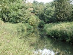
When I first joined the River Lark it was very narrow and looked little more than a large stream. As I went downstream I found several structures that looked as though they could have been the remains of locks. This made me curious, as I did not think that the river was wide enough or deep enough to allow boats along it, but the latter could have been fixed as locks artificially raise the water level anyway. Vegetation also tends to narrow rivers, as can be seen on some of the Cambridgeshire lodes, many of which were once navigable but now look little more than streams. Many thanks to Jim Barrett for pointing out that the River Lark was canalised in the past - see this site for more information. Indeed, the river was used to take stone to the Abbey in Bury St Edmunds. I could see that there were several pill boxes on the left as I walked along the river, which made me think that the River Lark must have bee seen as a strategic river in the second world war.
The West Stow Country Park and Anglo-Saxon village was a surprise find. I nipped into see if the shop was open but unfortunately it did not open until 11.00 and I was half an hour early. The village is built on the site of an excavated Anglo-Saxon village, and the buildings are modelled on what they found. Although you have to pay to actually enter the village I could see glimpses of thatched huts through the trees which looked very intriguing, and I shall have to go back and visit the site sometime when I have more time.
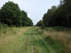
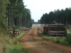
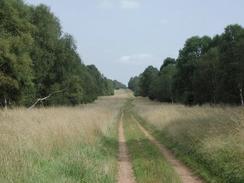
The King's Forest was a nice section of walk; the track through the trees was in a clearing which was so wide that you could have driven a dual carriageway through it - it is obviously the main haul road through the forest. At one stage I saw a fox on the path which stood looking at me until I got within about ten yards of it, when it finally decided to bolt off to the left. The trees nearer the path seem to be mainly silver birch, with coniferous trees further away, so I assume that the birches are there to act as a screen for the conifers.
At the end of the King's Forest the path meets the B1106 in a clearing, In the centre of the clearing is a stone monument, with the following inscription: "This tone commemorates the silver jubilee of King George the Fifth. The Forestry Commissioners began in 1936 to afforest the King's Forest and to plant with Beeches Queen Mary's Avenue, which follows the course of the Icknield Way. P.L. Robinson, Chairman, W.L. Taylor, Assistant Commissioner." It is a nice little monument, and fits in well with the forest behind it.
I had a little rest for twenty minutes at Barrow Clump so that I could rest my feet, which by this stage were starting to ache slightly. The previous night I had filled a litre Platypus bottle with Ribena and out in the freezer, and I used this opportunity to drink most of the resultant cool liquid. This rest did the trick, and when I set off once more there was no sign of any discomfort (aside from a wet feeling) in my feet.
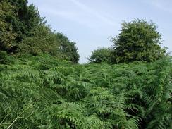
Some sections of the path uphill beside Marmansgrave Wood was incredibly overgrown with bracken or ferns - many of them were taller than me and progress was very slow. I would push the plants down but they would get wrapped around my legs and I would have to carefully extricate myself. The field to the right was clear and tantalisingly close, but here was a barbed wire fence that had to be climbed to get to it and I did not fancy doing that.
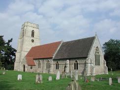
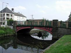
Thetford has some very nice buildings in it - the Thetford Grammar School is very nice, and the Town Bridge which was built in 1829 to replace a previous wooden toll bridge. The rings in the bridge were used to place chains across the road to stop traffic. The towpath beside the river (which I walked along a few weeks ago) was used by horses to tow lighters up the Little Ouse to King's Lynn. The bridge was built by a local Thetford firm, which was better known for making steam traction engines. St Peter's Church is one of three remaining medieval churches in Thetford and was rebuilt between 1789 and 1791. It is locally known as the 'Black Church' due to the use of knapped flint in the church tower.
When I arrived at Thetford Station I looked at the timetable to see when the next train to Ely arrived. The timetable stated that the next train was at 14.22, which was exactly the time that my watch said. I hurried onto the platform to see that there were people still waiting, and about thirty seconds later the train pulled in.
This walk has now completed a Cambridge - Ely - Thetford - Bury St Edmunds - Cambridge circular route.
Directions
This walk starts at Bury St Edmunds Railway Station. From the station turn left out of the building and head about fifty yards down to the A1101 Fornham Road. Turn left along the road and immediately pass under the railway line. Carry on northwards along the road, passing the ruins of the Hospital of St Saviour on the right before heading under the A14 dual carriageway. Continue past the junction with the B1106 until a car garage is reached. The Lark Valley Path leads off along a footpath to the right on the far side of the garage.
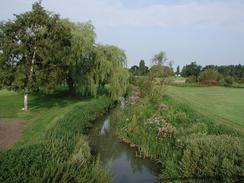
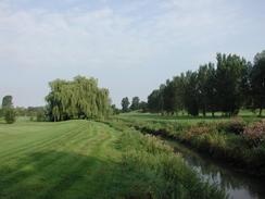
The path is grassy, and winds its way through an industrial area that is very smelly until it finally reaches the bank of the River Lark underneath some power lines and beside an electrical substation. Turn left and follow the path as it heads along the riverbank. Fairly soon the path becomes clearer as the well-mown greens of a golf course joins on the left. The path passes three pedestrian bridges - the second of which is very derelict and cannot be walked over - before the path meets the bridge over the B1106 road.
The path continues on the other side of the bridge, again following the western bank of the river. The golf course ends at the broad, and the terrain on the other side is much rougher and picturesque n both sides. When the path meets a concrete bridge over the river use it to cross the river and turn left to proceed down the eastern bank. The riverside path ends at another bridge that is only wide enough to walk or cycle over. There is a road that ends at the bridge; there are signs that there used to be a more substantial bridge over the river but that this was demolished and replaced with the current smaller one.
At the bridge turn right and head along the road (which is called Mill Road) as it heads south-north-eastwards through some trees up a slight hill. When it ends at a crossroads continue straight on for a few hundred yards along another road until it ends at a T-junction with the B1106 road. Cross to the other side of the B1106 where there is a pavement and turn left to head northwards for half a mile towards Culford. The road crosses a little stream by a bridge with attractive brick and flint walls and shortly afterwards reaches the imposing gateway leading to Culford School.
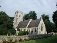
Turn left through the pretty gates and follow the tarmac driveway through the school grounds. It passes through an avenue of trees as it curves to the right before reaching a pretty little church. Continue straight on past the church until it meets a little roundabout in the school grounds. At the roundabout take the second exit to the left which head west, passing the main brick school building and continue on westwards along the track. The track is not surfaced and is quite stony, but it still allows good progress to be made. The track skirts to the north of a little lake, near the end of which a footpath leads off to the right. Take this footpath as it heads for about a hundred yards to end at a road opposite West Stow St Mary Church.
At the road turn left for a short distance before taking the first road off to the right which is signposted for Flempton. This leads westwards through a wooded area until it reaches a bridge over the River lark. At the bridge take a footpath that leads off to the right to follow the northern bank of the river. The first part of this path was fairly overgrown with nettles as it squeezed between the river to the left and a stream to the right, and I got stung through my trousers several times. This overgrown section did not last too long, however, and the path soon became clearer. The path passes a concrete bridge over the river. The path passes between the river and a little water treatment plant before entering a wooded area. A short distance into the wooded area the path leaves the river and turns tight to head through the trees until it nears a road. It then turns to the left through the trees before angling to the left back towards the river. It exits the trees next to an attractive brick pump house with a chimney.
Here there is a choice of routes; you can either turn left to continue along the river or head along the driveway to the pump house to the road. I chose the latter as I wanted to make good progress, so turn right and follow the driveway up to the road. A stile allows access onto the road, and turn left along the road. Fairly soon it passes the West Stow Anglo-Saxon Village, where there are toilets and a visitor centre. The road then goes along a long straight for about half a mile before it reaches a bend to the left with Leechmoor Cottage to the right. On the western side of the cottage the Icknield Way heads off to the right, up a sandy track.
Turn right and follow the Icknield Way north north eastwards for a couple of miles as it passes through the King's forest along a broad track up and down slight hills. Navigation is easy; just follow the track and do not take any sidetracks. Eventually the trees on the left end and are replaced with a field. The path skirts this field until it ends and is replaced with more trees for a short distance. The path along this section is much rougher and muddier, although it was so wide that I could avoid the muddiest sections. The path emerges from the trees at a clearing beside the B1106 road. In the centre of the clearing is a stone monument.
At the B1106 turn left and follow it northwards for about half a kilometre until a tarmac driveway leads off to the right, signposted for Barrow Clump. Turn right and follow this driveway past a pig farm and through a narrow band of trees. As soon as the trees end the Icknield Way heads off to the left beside the Old Barnham Slip. Turn left and follow the St Edmund Way as it heads north-eastwards uphill and then downhill beside the New Barnham Slip until it meets a concrete track which shortly ends at a road.
Cross the road and take the St Edmund Way as it heads north-north-eastwards uphill past Marmansgrave Wood. The path passes between two fences, with the forest to the left and a field to the right. Eventually the trees end and are replaced with a field. Continue on beside the field and some trees on the right until a broad band of trees marking the southern end of Thetford Warren and the Norfolk/Suffolk border is reached.
Walk straight on from the field into the band of trees for a few yards until a path running from the left to the right is reached. Turn right along this path and follow it eastwards. It soon joins a metal fence with Ministry of Defence signs warning people not to enter the area, which is part of Barnham Camp. Eventually the trees on the left end and are replaced by a field and the path continues on as the field ends and the path enters Barnhamcross Common.
A few yards into the common turn left down a track that heads northwards. The path passes under some power lines where it immediately turns to the right through the trees. When a clearing is reached turn left along a path which leads past a burnt out car (not a very long-lasting landmark!). The path finally emerges from the area of common land onto a school playing field. Angle slightly to the right to head towards the A134 road where the area of housing starts. Cross the A134 onto the pavement on he other side and turn left to head towards the centre of Thetford down the A134 Bury Road.
The A134 descends down a hill until you get to a disused and boarded up church on the left. Immediately by the church Bridge Road leads off to the right. Turn down Bridge Road and follow it past the pre-Conquest Thetford Grammar School which has a very nice building, including what looks like a chapel.
Cross the town bridge and continue on up Bridge Street towards St Peter's Church. Continue on past the church up White Hart Street, passing The King's Head pub on the left, which has a signboard featuring King Henry the First. When the road ends at Norwich Road use a pedestrian crossing to cross over to the north side of Norwich Road. Turn left and then immediately right up Station Road. Station road climbs slightly for a short distance to reach Thetford Station.
Distances
| From | To | Distance (m) | Ascent (ft) | Descent (ft) |
|---|---|---|---|---|
| Bury St Edmunds Station | West Stow | 5.5 | 75 | 112 |
| West Stow | Thetford Station | 12.3 | 354 | 338 |
This makes a total distance of 17.8 miles, with 429 feet of ascent and 450 feet of descent.
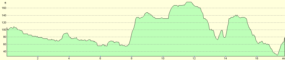
For more information on profiles, ascents and descents, see this page
Transport
There are regular train services from Thetford to Ely Station. From Ely there are some irregular services - either every one or two hours - from Ely to Bury St Edmunds.
Disclaimer
Please note that I take no responsibility for anything that may happen when following these directions. If you intend to follow this route, then please use the relevant maps and check the route out before you go out. As always when walking, use common sense and you should be fine.
If you find any information on any of these routes that is inaccurate, or you wish to add anything, then please email me.
All images on this site are © of the author. Any reproduction, retransmissions, or republication of all or part of any document found on this site is expressly prohibited, unless the author has explicitly granted its prior written consent to so reproduce, retransmit, or republish the material. All other rights reserved.
Although this site includes links providing convenient direct access to other Internet sites, I do not endorse, approve, certify or make warranties or representations as to the accuracy of the information on these sites.
And finally, enjoy your walking!
Nearby walks
| # | Title | Walk length (miles) |
|---|---|---|
| 105 | Newmarket to Bury St Edmunds | 21.7 |
| 106 | Bury St Edmunds to Stowmarket | 15.6 |
| 207 | Shippea Hill to Thetford | 20.2 |
|
|

|