Walk #211: Attleborough to Norwich
 |
 |
|
General Data
| Date Walked | 13/08/2002 |
| County | Norfolk |
| Start Location | Attleborough Station |
| End Location | Norwich Station |
| Start time | 09.17 |
| End time | 15.30 |
| Distance | 17.0 miles |
| Description | This was a long walk, mainly along quiet country lanes and one footpath through some nice, flat scenery. |
| Pack | I carried my 30-litre Karrimor Hotrock rucksack, which had a fleece, 2-litre Platypus and the usual odds and ends within it. |
| Condition | I feel fine after this walk, which was a relatively easy road walking with no major hills to climb. I wore my cross-trainers, and I have no blisters showing. I developed a very slight hotspot on the back of my heel on my right foot, but aside from that I was okay. My shoulders and back are fine, with no pain from either during this walk. |
| Weather | The day started off quite sunny, with a large blue canvas of sky. The sun was quite warm, and the temperatures soon reached about twenty-five degrees. As the day progressed it slowly get cloudier and although this kept the sun off me it did little to reduce the temperature. There was not much wind at all, and consequently it felt very muggy all day. |
| OS map | Landranger number 144 (Thetford & Diss, Breckland & Wymondham) and Landranger number 143 (Ely & Wisbech, Downham Market) |
 |
 |
|
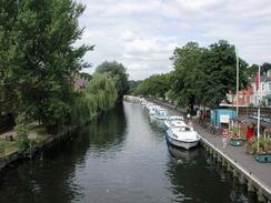 |
Map of the walk
Maps courtesy of Google Maps. Route for indicative purposes only, and may have been plotted after the walk. Please let me have comments on what you think of this new format. For a detailed table of timings for this walk, please see the table file.
Notes
This was an enjoyable walk which allowed me to finish off my walk from Ely to Norwich, which I did in two less days than I had planned. This was mainly due to the fact that I had planned to walk low mileages each day, but nonetheless it is nice to finish it early.
I was quietly minding my own business on the way from Suton to Wymondham when I heard a noise like a train in the distance to my right. Over the course of a few seconds the noise got louder and louder and as I looked up into the sky a twin-engined jet fighter came roaring overhead, seemingly so low that I could reach up and touch it. In less than a second it was gone, and I was left with only the noise slowly receding to my left.
Wymondham Station was very picturesque, and the first feature I noticed was that it had a very unusual footbridge over it with several different exits and angles on it. I studied this for a while before looking over the station, which was replete with garden boxes and looked very nice. The station building is currently used as the 'Brief Encounters' refreshment room, so I went in and had a glass of orange juice and a homemade sausage roll. The building also had a great deal of railway memorabilia inside it, and I spent five minutes looking around it. It was a truly fascinating little place, and the staff were very friendly.
The area around Ketteringham Hall was quite nice, with the church and the hall being the main points of interest. For people interested in cars there is another draw to the place, however; it is the home of Lotus Cars, whose factory is about a mile to the south of the Hall. In the car park of the Hall there were a fair few new Lotus's about, and I find it hard to think of a better setting for them.
As I approached Norwich I found a sign for the Tas Valley Way, which is a 26-mile (42 kilometre) walk from Attleborough to Norwich which could well be more scenic than the more direct route that I planned. For details contact the Countryside Access Team on (01603) 222769. There is also another walk from Wymondham to Norwich called Kett's Way, which is eleven miles long (about the same distance as that section of this walk).
On the way to Norwich Station through the city centre I stopped off at a Christian bookshop to enquire whether they had any books on church architecture. Unfortunately they did not, so I will have to have another look in Cambridge sometime soon. My haste earlier on in the walk was rewarded when I got to the station as I found that I had about twenty minutes to wait for my train, which was enough time to get a bottle of water to drink as I had emptied my Platypus.
There were once three station in Norwich - Norwich Thorpe, Norwich Victoria and Norwich City, of which only Norwich Thorpe now remains, the others having been closed. It is quite an impressive station building, and I must admit that I quite liked it.
There is now an obvious gap on the map of my completed walks between Norwich and North Walsham that needs filling. Although this could be done in one long walk, I have decided to do it in two shorter ones; from Norwich to Wroxham or Coltishall (which I may do as an indirect walk to lengthen it), from Wroxham to Aylsham following the Bure Valley Railway and Walk, and then from Aylsham to North Walsham following the Weavers' Way. This would mean that I have completed a walk right through the middle of East Anglia, and split my East Anglian Circular walk into two halves.
Directions
From Attleborough Station turn either left or right (depending on what platform you arrived at) to head north-westwards along the B1077 Station Road towards the centre of Attleborough, passing Connaught Hall. When you get to the war memorial turn slightly to the right up Surrogate Street. At a junction beside a church turn right down Besthorpe Road past a junior school and a new housing development until it reaches a mini roundabout. At the roundabout continue straight on as the road becomes Silver Street.
The road continues on in a roughly north-easterly direction for about a mile and a half until it reaches a bridge which climbs over the A11(T). Cross the bridge and descend to the other side for about a hundred yards until the road ends at a T-junction. At the junction turn right past the junction with Hill Road. About a hundred yards beyond the T-junction Golf Links road heads off to the left towards Wymndham College. Continue straight on until a roundabout is met with the B1172 London Road.
At the roundabout turn left along the B1172 and follow it north-eastwards for a short distance until Station Road leads off to the right. Turn down Station Road and follow it for about a hundred yards to another roundabout. At this roundabout turn left down a minor road which parallels the A11(T) and is signposted for Suton. Whilst the road parallels the A11(T) there is a pavement and it is quite wide, but when it started to head away the pavement ends and the road becomes narrower.
The road ends at a T-junction with Eleven Mile Lane. Turn right down Eleven Mile Lane and then immediately turn left past a red post box down Suton Street. Continue northeast down Suton Street past a nice brick Methodist Church until the road ends at a T-junction with Suton Lane. At the junction turn left to head northwards up Suton Lane.
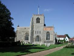
When Suton Lane ends at a T-junction with the B1172 London Road, turn right and walk along the pavement of the B1172 as it heads to the northeast. On the way there is a nice view of Wymondham Abbey to the left. Pass the fire station and cross over the preserved Mid Norfolk Railway on a bridge. Immediately on the other side of the bridge turn right down Cemetery Lane which parallels the railway line for a short distance before curving away to the left past the gates of the large cemetery. The road curves around to the right again before ending at Wymondham Station.
Follow the road past the station forecourt, as it becomes Station Approach and descends to end at a T-junction. At the junction turn left for a short distance before turning right down Ayton Road. This road slowly curves to the right before a long straight where there are some industrial units. It then bends to the left and ends at a roundabout. At the roundabout turn right down Browick Road and follow it as it cross the railway line using a level crossing and ends at a roundabout. At the roundabout continue straight onto the bridge over the A11(T) bridge. Cross the bridge and then head straight over the next roundabout.
A short distance on from the second roundabout Browick Road leads off to the left. Turn to the left and follow this road as it passes the lovely Browick Hall and the junction with Lower Spink's Lane. The road then continues straight for a fairly long distance past Brick Kiln Farm before curving to the right to meet the junction with St. Thomas' Lane. At this junction Browick Road becomes High Ash Lane. Continue straight on down High Ash Road towards Ketteringham.
When a sharp left-hand turn is reached, turn right down Church Road which heads past a lovely thatched cottage before turning to the left. It then heads eastwards for a short distance until it approaches a pretty stone sign denoting Hall Church. Pass to the left of the sign and continue on through two gates to a car park (which should have one or two Lotus's in it) near the hall. At the car park turn left down a narrow tarmac track which heads for a short distance through the trees. The track curves to the right to exit the trees and heads north-eastwards before turning to the right and heading northwards to end at a T-junction with High Street.
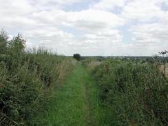
At the road turn right and continue along it until the road ends at a junction, opposite which is a stone monument dedicated to Queen Victoria's sixtieth year of her reign. At the junction continue straight on past the monument for ten yards down Cantley Lane until a bridleway is reached on the right. Turn right and follow this bridleway as it heads eastwards for about a mile to end at a track to the north of Lower East Carleton. At the track turn right for a few yards until it ends at a road.
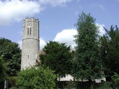
At the road turn left and follow it in a north-easterly direction until it bends sharply around to the left beside a round-spired Intwood Church. Continue on past the church and follow the road as it climbs up onto a bridge over the A47(T) before descending down the other side to a level crossing over a railway line. Cross the railway and continue up the road (which is called Intwood Road) as it climbs uphill until a crossroads is met at the top of the hill. Continue straight on over the crossroads and continue on down Intwood Road. When the road ends at a T-junction near a church turn right and cross over the River Yare and follow the road until it ends at a crossroads. Cross over the crossroads and continue on up Eaton Street. Eaton Street becomes a slip road off the A11 and shortly meets up with the A11 Newmarket Road.
Continue northeast along the A11 for about a mile until it meets a roundabout with the A140 road. At the roundabout turn right down the A140 road for about fifty yards to a pedestrian crossing, Use the crossing and then turn left to get back to the roundabout and turn right to head north-eastwards down the A11 once more. About a mile further on the road becomes St Stephens Road and ends at a roundabout. Use the pedestrian subway to cross under the roundabout and continue on down St Stephens Road into the city centre.
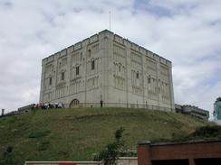
Continue down St Stephens Road and then Red Lion Street until a junction is reached. Turn left down Castle Meadow, which passes beside the castle mound. When a junction is met near a very impressive winged statue continue straight on down Prince of Wales Road. Cross over the River Wensum and the railway station is visible immediately opposite.
Distances
| From | To | Distance (m) | Ascent (ft) | Descent (ft) |
|---|---|---|---|---|
| Attleborough Station | Wymondham Station | 6.5 | 135 | 135 |
| Wymondham Station | Norwich Station | 10.8 | 335 | 443 |
This makes a total distance of 17.0 miles, with 470 feet of ascent and 578 feet of descent.
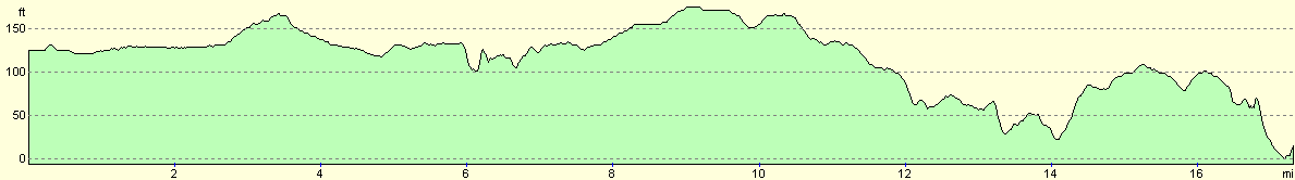
For more information on profiles, ascents and descents, see this page
Transport
There are regular train services running between Norwich and Attleborough, some of which call at Wymondham on the way. These services are run by Central Trains, on the Norwich to Ely route.
Disclaimer
Please note that I take no responsibility for anything that may happen when following these directions. If you intend to follow this route, then please use the relevant maps and check the route out before you go out. As always when walking, use common sense and you should be fine.
If you find any information on any of these routes that is inaccurate, or you wish to add anything, then please email me.
All images on this site are © of the author. Any reproduction, retransmissions, or republication of all or part of any document found on this site is expressly prohibited, unless the author has explicitly granted its prior written consent to so reproduce, retransmit, or republish the material. All other rights reserved.
Although this site includes links providing convenient direct access to other Internet sites, I do not endorse, approve, certify or make warranties or representations as to the accuracy of the information on these sites.
And finally, enjoy your walking!
Nearby walks
| # | Title | Walk length (miles) |
|---|---|---|
| 208 | Thetford to Attleborough | 16.9 |
| 221 | Acle Station to Norwich via Wroxham | 21.2 |
| 720 | Diss to Norwich | 24.2 |
|
|

|