Walk #208: Thetford to Attleborough
 |
 |
|
General Data
| Date Walked | 26/07/2002 |
| County | Norfolk |
| Start Location | Thetford Station |
| End Location | Attleborough Station |
| Start time | 08.53 |
| End time | 15.26 |
| Distance | 16.9 miles |
| Description | This was a long road walk through some relatively attractive scenery across Norfolk's rolling gentle hills. |
| Pack | I used my 30 litre Karrimor Hotrock rucksack, which was filled with a 1 litre Platypus water bottle, a book, a fleece and laughably a waterproof coat and a pair of waterproof trousers. |
| Condition | The main problem today has been the heat, and I think that I may have suffered a little from heatstroke. I felt quite hot and bothered at the end of the walk and I was finding it quite hard to concentrate, which is a sign of heatstroke. Before I started the walk I was mainly concerned about the blister on the fourth toe on my left foot, but this had not given me much trouble during the day. This should have been an easy walk, but the heat made it much harder than it should have been and I feel as though I have walked much further. When I got home and had a shower I found that I had some sweat rashes on my leg and feet, which is a sign of how hot it was. |
| Weather | The day started off with some cloud in the sky, but by the time I started the walk these were feathery and were starting to clear. As the day went on the sky became clearer and the sun became hotter, until eventually the temperature reached thirty degrees in some areas. In some places there was a slight breeze that helped to cool me off slightly, but unfortunately for most of the day I was sheltered from this. |
| OS map | Landranger number 144 (Thetford & Diss, Breckland & Wymondham) |
 |
 |
|
 |
Map of the walk
Maps courtesy of Google Maps. Route for indicative purposes only, and may have been plotted after the walk. Please let me have comments on what you think of this new format. For a detailed table of timings for this walk, please see the table file.
Notes
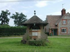
Near the end of Kilverstone park past the church I came across an overgrown stone that was inscribed as follows: "On this field His Majesty King George 6th inspected 2000 men of his tank corps, 27th April 1944.". This was a quite nice find, and is the sort of thing that you never get to see if you are driving and rarely if you are cycling. The field is now fairly nondescript, and shows no signs of being anything out of the ordinary.
St Mary the Virgin Parish Church of Bridgham with Roudham is a fairly distinctive little church. It has two distinct parts in slightly different stryles and a wooden-clad steeple. The flint and stone walls of the church look as if they have been extensively modified at some time, as repair work is very visible. Bridgham is quite a nice little village, with some nice houses and ramshackle barns flanking the road. Many of the walls show the ubiquitous flint of the area, which in my opinion makes a very attractive wall. At the eastern end of Bridgham I found some roadside Lavender growing, and I could not help but run my hands through it and smell the scent of the flowers.
It was quite a warm day, and as I was walking through Bridgham I found that I was starting to sweat profusely and I was starting to drink lots of my water put of my Platypus bottle. This was a slight problem as I had only packed a one-litre Platypus bottle, and I could tell this was soon going to disappear. Indeed, when we had set off from Cambridge it was so cloudy that I packed my fleece and coat, which with hindsight was totally unnecessary.
On the previous walk on Monday I had had big problems with blisters on the fourth toe on each foot. I had burst each one as usual, but the one on the left toe had been a blood blister, and as late as yesterday it had been bleeding. Before I set off I wrapped both affected toes in 1.5 centimetre Zinc Oxide tape and covered the whole area with Vaseline. Fortunately this has done the trick and although if I try to stand on my toes they ache, during normal walking everything is fine.
East Harling Church is made mainly of flint, and has a very attractive spire. I should think that the intricate nature of this spire is fairly unusual for a parish church, and I spent a few minutes studying it before I moved on. The Church is dedicated to St Peter and St Paul, and dates from the 15th century and has an attractive gateway entrance to the churchyard. The small triangular green in East Harling was small but picturesque, and the village sign on the green featured a carved lamb.
I decided that East Harling would be a good place to have a rest and to replenish my waster supply. There is a pub marked on the Ordnance Survey map down a road, but as I walked down this road I could not find it. I stopped a lady who was riding on her bike and she told me that there were two pubs in the village, so I turned around and headed back. The pub that I chose was the Swan Inn, which was a nice 15th century pub with nice wooden beams and which was bedecked with flower baskets. I had a pint of Green King IPA, which was followed, by a pint of orange and lemonade, and the barmaid kindly refilled my platypus with water.
As I approached Snetterton the sound of revving engines became audible. At first I thought that these were motorbike engines, but as I got closer I realised that they were in fact car engines racing around the Snetterton motor racing circuit. As I approached the circuit I could not resist having a quick look, and on the left there was a piece of waste ground between the road and the fence guarding the track. There was an abandoned car on the waste ground and some kind person had piled up a few tyres against the fence, which could be stood on to look over the fence. When I did so I could see cars including Porsches racing. I stood watching the cars go round for a few minutes, but I did not have a very good vantage point so I left to continue on the walk. As I left the circuit I heard the sound of squealing tyres, and looking over my left shoulder I could see a lot of dust rising into the air, so someone had obviously gone off into a gravel trap.
One feature of today's walk was the amount of dead animals on the road, with lots of birds, rabbits and hedgehogs lying dead on the road. As I was walking along the road between Eccles and Attleborough I saw a pigeon's head looking up at me from the road that was followed about a foot later by the pigeon's body. The head was intact and seemed to be looking up at me with a malicious gaze, which I found rather off-putting and freaky.
Attleborough Station was fairly picturesque with hanging baskets and a signalbox, which guarded the crossing gates. I must admit that it would be a shame if these manually operated gates were replaced with lifting barriers - the area around the station would not look the same. When I got to the station I was so hot that I sat in the shade under the canopy and took my shirt of so that it could dry out. I had about fifty minutes to wait for the train, so I lay down and read some of a Tom Clancy novel.
Directions
This walk starts at Thetford Station. Leave the station and exit the forecourt onto Station Road, passing the Railway Pub on the way. Pass by the ugly modern church of the Jesus Christ and the Later Day Saints on the left.
At the T-junction turn left onto Norwich Road. Pass some shops, a fire station and a police station until you reach a roundabout on the A1075 and A1066 roads. At the roundabout turn right down the A1066, which is called Hurth Way. On the opposite side of the road is a pavement, so carefully cross over the road. Follow the A1066 as it heads south-south-eastwards for a couple of hundred yards until some traffic lights protecting a pedestrian crossing are reached.
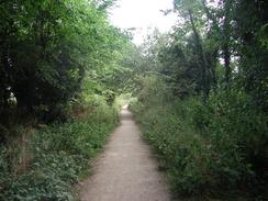
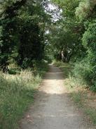
At the lights turn left and take a footpath and cycle path that is signposted for Kilverstone. This footpath heads in a north-easterly direction with houses on either side, crossing over a road and continuing on north-eastwards. The path is an attractive green avenue between two housing estates, but fairly soon some unkempt fields with some attractive trees acting as the border flank it. Unfortunately this does not last long, as the fields on the right are being built on for new houses, and the quiet was disturbed by the sound of radios, workmen's voices and JCB loadalls. The path passes to the right of a large Tesco store and then to the left of the Thetford Garden Centre before ending at a T-junction with a road.
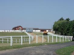
At the road turn right to head eastwards along the road past the entrance to the garden centre. The entrance to Kilverstone Hall is soon passed, which has a rather attractive gatehouse controlling the main driveway. Continue on along the road until you reach Langmere Boxes, where you pass some very attractive stables, which are laid out alongside the road in a symmetrical pattern. They are so nice I thought at first as I was approaching them that they were small cottages, but this was belied by the sign 'tack room' on the door of one of the cottages.
When the road reaches Brettenham do not take the road that goes off to the right towards the church but continue along the road you are on as it curves around to the left, which is signposted for Bridgham and East Harling. The road then heads in a north-easterly direction, crossing over the course of the Peddars Way Nay National Trail, before eventually reaching the village of Bridgham.
In Bridgham the road becomes called The Street. At the church a pavement starts which continues through the village until it ends at the eastern side of the village near Manor Farm.
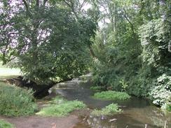
Continue along the road eastwards out of the village. The road passes the aptly named Flint Farm, which farmhouse is made of flint, until the road ends at a T-junction with the B1111. A mile to the left down the B1111 is Harling Road station, which has infrequent services along the Norwich to Ely line and is also the end of the Hereward Way. Our route avoids this; so turn right down the B1111 to head in a south-south-easterly direction. On the other side of the road from the junction is a pavement that makes the walk safer. The road crosses the River Thet by a bridge and then curves around to enter East Harling by Church Road. Pass East Harling Church.
Continue on along Church Road, passing the attractive but modern fire station before reaching the village green. Here the B1111 turns to the right, and a few yards away is the Swan Inn, which is where I chose to have lunch.
From the Swan Inn turn left down Market Street for a short distance. Shortly before the village green is reached a gravel path leads off to the right beside a pink house. At the end of the gravel path turn right down a tarmac path that ends at the end of a cul-de-sac called The Bailiwick. Continue along The Bailiwick until it ends at a T-junction with a road. Turn right and follow this road as it heads east out of the village, past the 1865 Methodist Chapel. At a crossroads continue straight on along Quidenham Road. Pass Drakes Close and continue along the road past the no speed limit signs.
When the junction with Eccles Road is reached on the left turn left down Eccles Road to head in a roughly northerly direction. After about a mile the road passes to the right of some white-fenced horse gallops before climbing to Bryant's Bridge over the railway line.
Pass the Snetterton motor racing circuit until the road curves around sharply to the left with a dead-end lane leading off to the right, do not follow the road but take the lane as it descends down to the railway line. Use the gates to cross over the line and once on the other side take the lane that leads off to the left. This lane soon ends at a crossroads turn left to head northwards down Station Road, which is signposted Attleborough 4 miles.
Follow Station Road for a short distance to Eccles Road Station, and cross the railway line using the level crossing beside the station. A short distance after the station the road curves to the right to head in a north-north-easterly direction. When the road ends at a T-junction marked with the station being three-quarters of a mile and Quiddenham two and a half miles, turn right and cross a brook by a bridge. Immediately on the other side of the bridge turn left to head north-north-eastwards once more. Continue along the road as it passes the entrance to Hargham Hall and enters a nice woodland area that gave me some shelter from the hot sun. After a couple of miles the road enters the southern end of the town of Attleborough and becomes Hargham Road.
When Hargham Road ends at a T-junction with another road in the centre of the town turn right down that road, passing a Sainsbury's store. When the road forks into a one-way system take the right hand fork that leads through some one-way signs into a street called Connaught Plain. Continue up Connaught Plain passing to the right of the library. Immediately before the road turns to the left turn right down Station Road past a very attractive war memorial. Attleborough Station is a short distance down Station Road, with the platform to trains to Norwich being on this side of the crossing, and the platform for trains to Ely and Peterborough on the far side of the crossing.
Distances
| From | To | Distance (m) | Ascent (ft) | Descent (ft) |
|---|---|---|---|---|
| Thetford | East Harling | 9.3 | 246 | 262 |
| East Harling | Attleborough | 7.6 | 203 | 151 |
This makes a total distance of 16.9 miles, with 449 feet of ascent and 413 feet of descent.
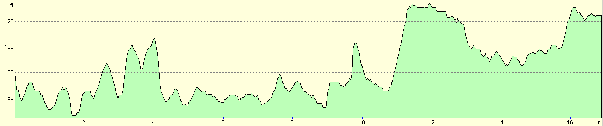
For more information on profiles, ascents and descents, see this page
Transport
There are regular railway services running between Attleborough and Thetford. These trains are run by Central Trains on the Norwich to Peterborough route. In September 2002 trains running from Norwich to Cambridge will also serve the two stations.
Disclaimer
Please note that I take no responsibility for anything that may happen when following these directions. If you intend to follow this route, then please use the relevant maps and check the route out before you go out. As always when walking, use common sense and you should be fine.
If you find any information on any of these routes that is inaccurate, or you wish to add anything, then please email me.
All images on this site are © of the author. Any reproduction, retransmissions, or republication of all or part of any document found on this site is expressly prohibited, unless the author has explicitly granted its prior written consent to so reproduce, retransmit, or republish the material. All other rights reserved.
Although this site includes links providing convenient direct access to other Internet sites, I do not endorse, approve, certify or make warranties or representations as to the accuracy of the information on these sites.
And finally, enjoy your walking!
Nearby walks
| # | Title | Walk length (miles) |
|---|---|---|
| 207 | Shippea Hill to Thetford | 20.2 |
| 211 | Attleborough to Norwich | 17.0 |
| 212 | Bury St Edmunds to Thetford | 17.8 |
|
|

|