Walk #209: Dunstable to Harpenden via Luton
 |
 |
|
 |
 |
|
General Data
| Date Walked | 30/07/2002 |
| County | Bedfordshire, Hertfordshire |
| Start Location | Dunstable |
| End Location | Harpenden station |
| Start time | 11.20 |
| End time | 16.07 |
| Distance | 12.1 miles |
| Description | This was definitely a walk of three thirds; a surprisingly nice walk from Dunstable eastwards to the M1 was followed by a boring trudge through Luton. The last part of the walk south-eastwards from Luton was quite nice, for the most part following an old abandoned railway line. |
| Pack | I carried my 30-litre Karrimor Hotrock rucksack that contained a waterproof coat, trousers, fleece and various other odds and ends within it. |
| Condition | I feel fine after this walk, which is to be expected, as it was a shorter walk than the others that I have been doing recently. The biggest problem is my left ankle, which is aching slightly after I twisted it slightly whilst making my way towards Harpenden. |
| Weather | The weather today was quite hot and humid; although it was not as humid as it has been over the past few days. There was a low cloud cover all day, and I only ever got a couple of glimpses of the sun. It felt quite muggy and oppressive, and I was concerned that there may be a thunderstorm. Fortunately the only precipitation was a few spots of rain towards the end of the walk as I was walking through Harpenden. |
| OS map | Landranger number 166 (Luton & Hertford, Hitchin & St Albans) |
 |
Map of the walk
Maps courtesy of Google Maps. Route for indicative purposes only, and may have been plotted after the walk. Please let me have comments on what you think of this new format. For a detailed table of timings for this walk, please see the table file.
Notes
This was a walk that I had been meaning to do for some time, as it fills in a gap between walks done from Dunstable and walks done from Luton. I had been putting off doing it for a long time, as I did not expect it to be through very nice scenery. However this morning I had something to do in Hitchin early this morning, so I decided that it would be a good idea to get this walk done at the same time.
The car park in Dunstable is dominated by the large and imposing priory church of St Peter, which is the remains of Dunstable. King Henry 1st founded the Augustinian Priory. In 1131 and it took over a century to complete. In 1545 it was dissolved along with other monasteries as part of the reformation.
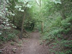
I had been expecting the walk between Dunstable and Luton to be a boring trudge, but I was relieved to find that this was mainly not the case. In Dunstable the route follows the Icknield Way, which skirts the edge of Blow's Down and the old, disused Luton to Dunstable railway line (itself an avenue of green) before finally reaching the M1 and roads. Blow's Down SSSI is part of the chalk escarpment of the southern end of the Chiltern hill range and the grasslands of the Down is important for breeding and migratory birds.
The outskirts of Luton were very dinghy, and generally not very nice. Many of the streets had disused cars that were in a decrepit state and which were filled with old tyres and other rubbish. Some of the houses were boarded up and the whole area was very unkempt and unloved.
There are plans to replace the disused Luton to Dunstable railway line with a guided bus system between the two towns. There is also a fledgling railway preservation project on the line, and the misguided bus proposal is becoming quite controversial.
Sam phoned me up at about midday to tell me that they had a very large thunderstorm where she work in Ely and that they had had two power cuts. This news made me worry slightly about whether I was going to get caught in a thunderstorm, but fortunately one did not materialise during the walk, although I drove home through a large storm.
I did not have a stop for lunch, but on the way down Windmill Road I passed a little sandwich van where I bought a bacon sandwich to keep me going. This was enough to last me for the entire walk, as it was not too strenuous.
Whilst passing under the bridge under the railway to join the B653 road I fell over and twisted my bad ankle. This caused me to fly forwards for about ten yards whilst I tried to keep my balance without putting any weight on the injured ankle. Eventually I stopped just before the road was reached and I sat down for a few minutes until the pain started to subside. it ached at times for the rest of the walk, particularly when crossing rough ground, but I was not overly concerned about it.
Whilst on the way from Luton to Harpenden I started to realise that I was walking along the remains of an old railway line. This impression became reinforced when the path entered a cutting and then ran on an embankment before ending at the B653 road where a brick bridge abutment could be seen on the other side of the road. I do not know the history of this line, but it made for an easy walk into Harpenden.
When I got to Harpenden Station I was lucky that I had only to wait three minutes for a train. When I got to Luton Station I went to the bus station to find out the times of busses back to Dunstable. Luton bus station is a very ugly, modern building, which is sat directly underneath a multi-storey car park. There were few signs about, the information point was boarded up and the air was heavy with diesel fumes. Eventually I found a sign that stated that busses to Dunstable left from Station Road and not the bus station, which I found highly annoying. The dismal state of the bus station should be easy to improve; the addition of more, brighter lighting, more signs and a repaint would work wonders.
This walk has filled a missing gap between Luton and Dunstable and in doing so has finished off a large circular walk. Extending the walk down to Harpenden will also allow me to follow the river Lea down the Lea Valley to Hoddesden, thus linking it up with my Land's End to John O'Groats walk.
Directions
This walk starts off in the Church Close car park in Dunstable, which is a long-stay car park, which costs 4 pounds to park the car for a day. Leave the car park and turn left by the church to head down Church Close for about fifty yards until it ends at a T-junction with the A505.
At the A505 turn right past the church and continue along in an eastwards direction. Pass the attractive thatched 'Norman King' pub and continue on along the A505 with the graveyard of the priory church on your right. Shortly after a Texaco garage and a pub called the 'First and Last' on the right and shortly before you reach the blue railway bridge over the road turn right down Station Road.
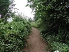
After a short distance Station Road becomes Great Northern Road and curves around to the right. At the bend a path heads on straight ahead, marked by an Icknield Way signpost. The path has a cut bark surface, which makes a very nice walking surface but was slightly overgrown by nettles and weeds. Continue on along the path through some fields and towards some power lines. The path passes directly under the pylon of a transmission tower of the power lines until it meets the end of a road. At this point an Icknield Way sign points off to the left down a track that is initially flanked on either side by trees and hedges.
The track is very pleasant, and is only spoilt by the sound of industry coming from the left. After a while the hedge on the right stops and you start walking along the edge of the Down itself. At this point the disused Luton to Dunstable railway line curves in to the left, the track being virtually hidden by the undergrowth growing between the sleepers.
The path ascends a slight hill with the railway line in a cutting to the left before descending down to meet the railway line once more. At the end of Blow's Down the Icknield Way joins a short tarmac path that leads down to a roundabout on the A505 whilst the railway line continues overhead on a bridge. At the roundabout cross over the slip road and continue up a road on the other side up signposted Caddington Residential Park.
The road climbs up to run alongside the right-hand side of the disused railway line once more. It may be possible to cross the roundabout by walking over the railway bridge, but it looks like it is very overgrown. When the road ends at Caddington Park continue straight on past a gate down an old piece of road, which still has white lines running down the middle of it.
At the end of the section of old road a path leads off to the left. This path goes through an attractive little patch of grassland towards some power lines before branching to the left and right. The branch to the right leads up some steps to the A505, but this walk follows the left-hand branch, which heads off towards a footbridge that climbs over the old railway line.
Cross the railway line and descend the other side of the bridge. Follow the path as it turns to the left between two fences and then almost immediately to the right. When the path ends at a T-junction with Bradley Road beside the bridge over the M1 turn right and cross over the M1. On the other side of the bridge continue on along Bradley Road.
The road descends a slight dip and then climbs up the other side before ending at a T-junction with another road. At the T-junction turn left for about a hundred yards and then take the first right down Carisbrooke Road. When the road ends at a T-junction with Chaul End Lane turn right and follow the road as it passes over the old railway line. On the other side of the bridge take a subway that leads under a roundabout and then climb up to meet a road to the right of a Volvo garage. Continue straight on past the garage and then take the first road to the left, Cosgrove Way that leads for about thirty yards to another roundabout.
At the roundabout turn right down Dallow Road. After about a hundred yards this road turns to the left to head in a roughly easterly direction. Immediately past the bend the road meets a little mini roundabout. Continue straight on past the roundabout for about a kilometre to some traffic lights that protect the junction with Kingsway on the left. A little over a mile after this junction the road turns to the left past a recreation ground on the right and a Sikh temple on the left and ends at a T-junction with a main road.
At the junction ensure that you are on the left-hand side of the road. Here a path rises up and turns to meet a footbridge over a busy roundabout. Cross the bridge to the centre of the roundabout and then take the right fork to the eastern side of the roundabout. At the other side turn right and ten left past the Liverpool Road Health Centre and then to a car park. Continue straight on down Mersey Place until it ends at a T-junction with another road.
At the T-junction turn left down Liverpool Road for a hundred yards until it ends at a T-junction with Collingdon Street. Turn right and then head down Collingdon Street towards the 11-screen cinema complex. When Collingdon Street forks take the right-hand branch and head down beside the cinema. Cross Alma street using a Pelican crossing which then leads into the centre of Luton. Continue on a little distance and then turn left down Bridge Street. Cross Library Road and pass under a bridge leading from the cinema complex and pass the Bridge Tavern. Use a blue subway to get under the disused railway line and then on the other side turn right down Station Road, which leads to Luton Station.
From Luton Station continue on down Station Road, passing under the bridge leading to the Arndale shopping centre on the way. When Station Road ends at a T-junction turn right and pass under a railway bridge and then left down the dual carriageway Church Street. This leads to a large roundabout, which can be crossed using a subway. Continue on down the A505 Windmill Roads which becomes Gipsy Lane and ends at another roundabout by the Vauxhall Recreation Ground.
At the roundabout continue along the pavement as it starts to descend and then take a branch off to the left which passes under Gipsy Lane. On the other side you emerge on Parkway road beside the exit to a multi-storey car park. Here there is a sign for the Lea Valley way, which will be followed to Harpenden. Turn right for a few yards up Parkway Road to a roundabout beside a BR station sign. At the roundabout turn left down Lower Harpenden Road, which leads towards a bridge under the A505. Just before the bridge is reached the pavement leave the road and turns to the left to climb up a slope and some steps between a chain link fence and a hedge onto the A505.
On the A505 turn left and follow the road as it crosses over the railway line following the Lea Valley Walk signs. Continue on for about fifty yards past the bridge and then turn right and very carefully cross the busy main road. On the other side of the road some steps lead up the side of the road cutting.
At the top of the cutting follow the path as it follows the chain-link fence that guards Luton airport. The path descends into a little valley and when the fence turns to the left along the bottom of the valley turn right across a field towards the railway line and a house. At the house pass under a large bridge under the railway line and join the B653 road on the other side of the bridge.
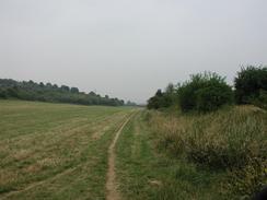
Turn left and wall along the B653 for a few yards to a stile that leads to a field that is squeezed between the railway line and the road. This field continues south-eastwards between the two for about a mile before ending at a minor road which leads up to Copt Hall. The Lea Valley Walk continues on the other side of the road and heads through some woodland along what is obviously an old railway line that runs in a cutting. The cutting becomes an embankment which ends at the B653 road where there was obviously once a bridge carrying the line over the road.
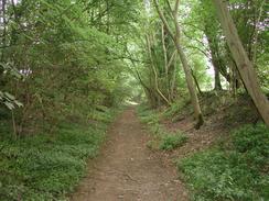
Turn left along the B653 for about ten yards and then carefully cross the road and take a footpath that heads off to the right. The path heads up onto the top of the railway embankment once more. At the top of the embankment turn left and follow to the right of a metal palisade fence which heads through an area of woodland before ending at a road. Cross a stile onto the road and follow the path as it continues on the other side of the road. Pass an overgrown platform and continue alongside the palisade fence which guards a sewage works.
The path follows the railway embankment and the palisade fence until it reaches a bridge under the Harpenden to Luton railway line. Here the path leaves the disused railway line and climbs up some steps to the right and then goes through a field to end at another road. At the road turn left following the Lea Valley Walk signs and descend under the railway line. About a hundred yards downhill from the bridge the path rejoins the disused railway line and climbs up to the top of the railway embankment to continue south-south-eastwards.
After a mile the path meets the edge of a housing estate. Continue on along the path as it enters a little cutting, which abruptly ends at a filled-in bridge. Climb up to the road and cross it before continuing along the path. The path crosses over a little road on a bridge before ending at a road in the centre of Harpenden. Join the road, which is called Coldharbour Lane, and then turn right up Station Road past a modern church on the left. The road turns to the right and cross a bridge over the old railway line before ascending a small hill. It then descends the other side of the hill towards a pedestrian crossing and a railway bridge. Shortly before the bridge is reached and after the crossing turn left up to the station car park. Harpenden Station is then slightly to the right through the car park.
Distances
| From | To | Distance (m) | Ascent (ft) | Descent (ft) |
|---|---|---|---|---|
| Dunstable | Luton Station | 5.5 | 203 | 312 |
| Luton Station | Harpenden Station | 6.6 | 509 | 499 |
This makes a total distance of 12.1 miles, with 712 feet of ascent and 811 feet of descent.
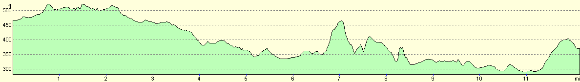
For more information on profiles, ascents and descents, see this page
Transport
There are regular train services run by Thameslink between Harpenden and Luton. The train fare for a single costs £2.70. From Luton regular bus services (service 31) run from Luton back to the centre of Dunstable and cost £1.45. Unfortunately these services do not run from Luton bus station but from Station Road outside the station, a fact that took some working out.
Disclaimer
Please note that I take no responsibility for anything that may happen when following these directions. If you intend to follow this route, then please use the relevant maps and check the route out before you go out. As always when walking, use common sense and you should be fine.
If you find any information on any of these routes that is inaccurate, or you wish to add anything, then please email me.
All images on this site are © of the author. Any reproduction, retransmissions, or republication of all or part of any document found on this site is expressly prohibited, unless the author has explicitly granted its prior written consent to so reproduce, retransmit, or republish the material. All other rights reserved.
Although this site includes links providing convenient direct access to other Internet sites, I do not endorse, approve, certify or make warranties or representations as to the accuracy of the information on these sites.
And finally, enjoy your walking!
Nearby walks
| # | Title | Walk length (miles) |
|---|---|---|
| 127 | Hitchin to Luton | 13.2 |
| 129 | Dunstable to Tring | 14.1 |
| 143 | Cheddington Station to Bletchley Station | 13.3 |
|
|

|