Walk #129: Dunstable to Tring
 |
 |
|
General Data
| Date Walked | 16/12/2000 |
| County | Hertfordshire, Buckinghamshire, Bedfordshire |
| Start Location | Dunstable |
| End Location | Tring |
| Start time | 09.50 |
| End time | 15.25 |
| Distance | 14.1 miles |
| Description | This was a pleasant walk following the Icknield Way and the Ridgeway, visiting Bedfordshire's highest point and Ivinghoe Beacon in the process. |
| Pack | Today I carried a full pack with no tent. |
| Condition | I am a bit fatigued, and my right shoulder is aching slightly as my pack was not sitting on it correctly. My legs and feet are in reasonable condition, and my back is fine. All in all I am feeling very good considering it was not a short or easy walk. |
| Weather | Today's weather was nice. It was cold all day after a heavy overnight frost, which survived all day in sheltered places. Despite thisI did not get too cold, mainly due to the fact that there was not much wind except in exposed locations. There was thin cloud overhead all day, with occasional glimpses of the sun and no sign of any rain. All in all an excellent day for walking. |
| OS map | Landranger number 165 (Aylesbury & Leighton Buzzard, Thame & Berkhamstead) and Landranger number 166 (Luton & Hertford, Hitchin & St Albans) |
 |
 |
|
Map of the walk
Maps courtesy of Google Maps. Route for indicative purposes only, and may have been plotted after the walk. Please let me have comments on what you think of this new format. For a detailed table of timings for this walk, please see the table file.
Notes
This was an excellent day, the sort the makes my walking worthwhile. For most of the day there were some lovely views, in particular the last half of the journey to Tring Station. Most of the day was spent on footpaths, following the Icknield Way and Ridgeway over ground that was not too muddy due to the hard frost of the previous night. It was a welcome relief from the muddy bog-trotting that I have had to do over the last few weeks.
Unfortunately I reached Tring at 15.25, eighteen minutes after the previous bus back to Dunstable had left, so I am having to wait for the next bus at 17.42. Therefore I am waiting in a pub (The Bell) in the centre of town and having a couple of pints of coke whilst I wait and write these notes. I would prefer not to have to wait for the bus, but I am at least getting the chance to savour the local colour.
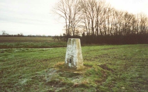
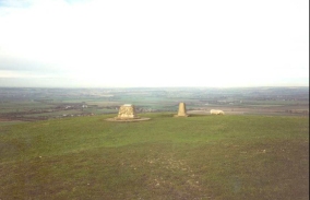
Today's walk visited Bedfordshire's highest point which gives me another one to tick off my list. It is at a trig point just to the south of Dunstable Downs, from where some lovely views were available to the east and south. It also featured the superb Ivinghoe Beacon, the end of the Icknield Way and the start of the Ridgeway. The views from here were lovely in all directions, and people were flying large model aircraft from the top - how they could stand stationary in the cold wind for such a log time I do not know. Whilst I was there a large glider from the nearby gliding club flew over - a lovely sight.
I still have to complete the Luton to Dunstable section of the walk to connect this walk up with the previous ones that I have done. Because this will be a short walk (probably about six or seven miles) I will extend it by starting at Harpenden and heading north into Luton and then westwards to Dunstable.
The next section of the walk west from Tring will be a circular one to Wendover, Aylesbury and back, taking in the highest points of two counties. Now that I have reached the Grand Union Canal I can walk there from West Drayton to the south (making an alternative Land's End to John O'Groats walk, and north to Northampton and Birmingham.
All in all I am quite pleased despite my enforced wait - I have now done over 950 miles this year, a good mileage and I may be able to reach the magic 1,000 mile mark by the end of the year. If I do not manage it I will not be too disappointed however, as it has been a marvellous year of walking where I have achieved (and exceeded) all my other aims. Tring was a very nice little town, quite compact and nice in the fading winter afternoon's night.
Directions
This route follows either the Icknield Way or the Ridgeway for it's entire route, excepting a section on Dunstable Downs where I went to visit the Trig point, which is Bedfordshire's highest point. Because it follows these well-known long distance paths, they are very well signposted, in particular the sections along the Ridgeway.
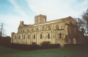
This walk starts at the long-stay car park by the Priory in Dunstable, just off the A505. Turn left onto the A505 and then left again sown the A5(T). Almost immediately a sign takes you to the right and heads through a car park. Continue on along an insignificant gravel track, which soon becomes wider and paved beside a cemetery. At the end of this road turn left and then right, up a small hill. When this road curves to the left continue uphill along a narrow track. This soon brings you out onto some open land and you cross a golf course. Pass the golf course clubhouse and continue in a roughly southerly direction until the path meets the B5451 road.
The Icknield Way continue on over the road past the viewpoint, but as I wanted to visit the trig point at Bedfordshire's highest point, I turned left up the road for a short distance. Pass a minor road junction and when the road bends slightly to the left a farm track leads off to the right. At the junction of the road and the farm track is the trig point. Turn right down the farm track as it leads towards Chute Farm. Pass under two high-tension power lines and head towards an area of woodland. Do not enter the woodland, but turn right down a path that skirts the eastern edge of the woodland. When you reach the northern edge of the woods continue downhill for a short distance. When you meet the power cables again turn left and contour the hillside. The path drops down to nearly, but not quite, meet a car park on the B4540, and then rise up from it to the southeast. Continue onwards and enter the tree cathedral at Whipsnade. Exit this fascinating area of woodland and join the B4540.
Turn right along the road for a short distance and then turn left to descend down to a track that leads to the southeast. Turn left down this track as it skirts to the left of a chain link fence, behind which is Whipsnade Wild Animal park. When the fence turns to the right, leave the track and take a footpath that heads off to the right beside the fence and continues southwards.
Continue following the fence as it weaves in-and-out slightly for about a mile. The path then leaves the fencing and the park and heads southwestwards through a golf course. Follow the signs through the golf course (taking care of people teeing off and flying golf balls). The path turns to the right to head northeastwards past the car parks for the golf course and enters some woodland. The path then descends to meet a road. Turn right down this road for a short distance and then left down a footpath that leads through fields to meet the A4146 in Dagnall. Turn right down this road for a short distance, cross over a roundabout between the A4146 and B4506. Pass a pub and continue until you meet a track leading off to the left.
Turn left down this path, and follow it as it heads straight to the southwest past the turnoff for Dagnall Farm. The track then starts to climb uphill past some woodland and emerges out by Ward's Hurst Farm. On the outskirts of the farm the path turns right and enters some woodland. As it enters the woodland it starts to descend quite steeply, but fortunately there are steps down the steepest sections. At the bottom of the hill the path meets the edge of the woodland and some fields. The path angles in slightly away from the edge of the woodland and goes through the wood. When it emerges the path heads slightly uphill and then angles to the south-northwest. It then starts to climb up to meet a minor road. At this road turn right and head north over a small hill, before descending and then climbing again to the top of Ivinghoe Beacon.
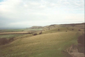
Ivinghoe Beacon is the western end of the Icknield Way and the eastern end of the Ridgeway, and superb views are available n all directions. There is also a sign showing you the length of the Ridgeway beside the Trig Point. Turn around and descend back down to the road. Cross the road and head up the hill to the south. Reach the hill and then contour the side for a while, When a magnificent valley opens up to your right contour the valley end and turn right. Head southwest across fields to a road and car park.
Turn left down the road for a short distance and then almost immediately right again, past a picnic site attached to the car park. Rise up a hill and continue along the top of Pristone Hill, from where some lovely views are available. The path then enters and leaves some woodland, and then enters it again before dropping down to a lower elevation and turning to the south-southeast.
The path then leaves the woodland and continues on a nice track. Just to the east of Westland Farm it turns to the right, joins a drive and then a road. Turn right down the road and follow it to the bridge over the railway line at Tring and Tring station. Continue along this road as it crosses over the Grand Union Canal. When it bends to the left turn right and head westwards for a mile and a half into the centre of Tring.
Distances
| From | To | Distance (m) | Ascent (ft) | Descent (ft) |
|---|---|---|---|---|
| Dunstable | Dunstable Downs | 2.0 | 328 | 3 |
| Dunstable Downs | Ivinghoe Beacon | 6.9 | 633 | 702 |
| Ivinghoe Beacon | Tring | 5.2 | 354 | 640 |
This makes a total distance of 14.1 miles, with 1315 feet of ascent and 1345 feet of descent.
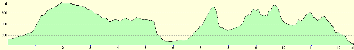
For more information on profiles, ascents and descents, see this page
Disclaimer
Please note that I take no responsibility for anything that may happen when following these directions. If you intend to follow this route, then please use the relevant maps and check the route out before you go out. As always when walking, use common sense and you should be fine.
If you find any information on any of these routes that is inaccurate, or you wish to add anything, then please email me.
All images on this site are © of the author. Any reproduction, retransmissions, or republication of all or part of any document found on this site is expressly prohibited, unless the author has explicitly granted its prior written consent to so reproduce, retransmit, or republish the material. All other rights reserved.
Although this site includes links providing convenient direct access to other Internet sites, I do not endorse, approve, certify or make warranties or representations as to the accuracy of the information on these sites.
And finally, enjoy your walking!
Nearby walks
| # | Title | Walk length (miles) |
|---|---|---|
| 127 | Hitchin to Luton | 13.2 |
| 130 | Tring Station to Hemel Hempstead Station | 8.0 |
| 141 | Tring Station to Cheddington Station | 6.1 |
|
|

|