Walk #24: The Weaver Hills
General Data
| Date Walked | 26/05/1999 |
| County | Staffordshire |
| Start Location | Wooton |
| End Location | Wooton |
| Start time | 11.15 |
| End time | 14.35 |
| Distance | 6.0 miles |
| Description | This was a pleasant little stroll over the Weaver Hills, then heading past the quarries back to Wootton. |
| Pack | My pack was light; I carried no tent, only the 2.5 litre water bottle, a few spare clothes and the Trangia. |
| Condition | I feel fine after this nice walk. My thighs were irritated by the previous chaffing but did not suffer unduly. |
| Weather | The weather today was overcast and far from pleasant. |
| OS map | Landranger number 128 (Derby & Burton upon Trent) |
Map of the walk
Maps courtesy of Google Maps. Route for indicative purposes only, and may have been plotted after the walk. Please let me have comments on what you think of this new format. For a detailed table of timings for this walk, please see the table file.
Notes
This was a pleasant walk over the Weaver Hills. These are the southernmost extremity of the limestone Peak District, an outlier some miles south of the famous Dovedales. As such, there are some superb views over the plains to the south towards Cannock Chase. Unfortunately its locations means that the western end of the hills is dominated by a couple of large quarries. In the future I will miss out the quarry section and head immediately north from the Weavers.
Directions
This walk starts off in the little hamlet of Wooton at SK105451. Head west out of the village; after a short distance turn right up Gidacre Lane. This heads northwestwards, initially climbing slowly. When the track ends continue on along a footpath that becomes increasingly steep as it crosses fields to a gap between two of the three summits on the Weaver Hills.
When at the little saddle I turned to the left to climb up to the trig pillar on the western, highest summit; I then returned and headed eastwards to the two other, slightly lower tops. At the 359-metre summit I headed north to reach a footpath that runs against a wall. Turn left and follow this footpath as it heads westwards, slowly swinging to a northwestwards course.
After a mile it meets the northern edge of a quarry; continue on northwestwards along the quarry. There is a chance that quarrying may have caused some of these footpaths to be diverted. The path curves slightly to the right; just before it meets the A52 at SK085476 turn left along another footpath. After a fifth of a mile take another footpath that leads off to the left, heading southwestwards before curving southwards and finally southeastwards, passing the western edge of the quarry.
At SK083470 the footpath jinks to the right; continue on southwards along a footpath for nearly a mile until it reaches a road at Sycamore Farm. Here turn left to follow the road southeastwards. After a short distance turn left along another road that heads in a rough easterly direction for a mile and a half back towards Wooton.
Distances
| From | To | Distance (m) | Ascent (ft) | Descent (ft) |
|---|---|---|---|---|
| Wooton | Wardlow | 3.0 | 379 | 266 |
| Wardlow | Wooton | 3.6 | 279 | 692 |
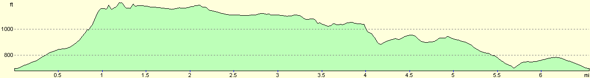
This makes a total distance of 6.6 miles, with 658 feet of ascent and 958 feet of descent.
For more information on profiles, ascents and descents, see this page
Disclaimer
Please note that I take no responsibility for anything that may happen when following these directions. If you intend to follow this route, then please use the relevant maps and check the route out before you go out. As always when walking, use common sense and you should be fine.
If you find any information on any of these routes that is inaccurate, or you wish to add anything, then please email me.
All images on this site are © of the author. Any reproduction, retransmissions, or republication of all or part of any document found on this site is expressly prohibited, unless the author has explicitly granted its prior written consent to so reproduce, retransmit, or republish the material. All other rights reserved.
Although this site includes links providing convenient direct access to other Internet sites, I do not endorse, approve, certify or make warranties or representations as to the accuracy of the information on these sites.
And finally, enjoy your walking!
Nearby walks
| # | Title | Walk length (miles) |
|---|---|---|
| 2 | Waterbeach to Newmarket Road, Cambridge | 5.4 |
| 3 | Littleport to Downham Market | 14.0 |
| 5 | A short walk around Waterbeach to Car Dyke | 3.0 |
|
|

|