Walk #392: Newport to Cardigan
 |
 |
|
General Data
| Date Walked | 23/03/2003 |
| County | Dyfed |
| Start Location | Newport |
| End Location | Cardigan |
| Start time | 09.32 |
| End time | 17.10 |
| Distance | 17.5 miles |
| Description | This was a lovely but strenuous walk over some beautiful terrain, with some lovely views available. |
| Pack | Today I carried my 30-litre Karrimor HotRock rucksack, which was filled with my packed lunch, waterproof leggings, water bottle and a couple of spare shirts, together with the usual assortment of odds and ends. |
| Condition | I feel absolutely fine after this walk, and have no major problems to report. I felt much better than I did yesterday, and I found the walk to be quite easy despite the heat. |
| Weather | Today was the hottest day of the year so far, with bright sunshine all day and no clouds in the sky. Fortunately there was a nice breeze that helped me keep cool when I was on the high cliffs, All in all it was a superb day for walking. |
| OS map | Landranger number 145 (Cardigan & Mynydd Preseli) |
 |
 |
|
 |
 |
|
Map of the walk
Maps courtesy of Google Maps. Route for indicative purposes only, and may have been plotted after the walk. Please let me have comments on what you think of this new format. For a detailed table of timings for this walk, please see the table file.
Notes
This was a massively enjoyable walk over some quite tough terrain, but nonetheless I enjoyed it much more than I enjoyed yesterday's walk. I had none of the queasiness that I had yesterday, and this alone meant that I found the walk much more enjoyable.
The day started off with Sam waking me up with a happy birthday kiss, after which we got up and put the television on ready to watch the start of the Malaysian Grand Prix. Whilst it was on I wrote up my notes for yesterdays walk, and Sam prepared breakfast - which was a most unusual combination of birthday cake and cheese on toast! The grand prix was quite patchable, and I stayed until the end so that I could watch the finish - which is more than can be said for the races last year, which means that the rules changes have worked.
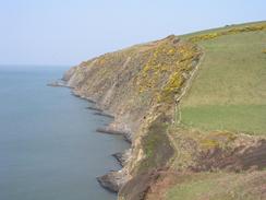
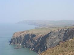
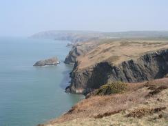
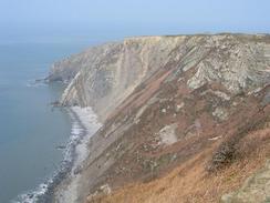
Today's walk was quite hard going, and the guide book claims that there is over 3,000 feet of ascent on this walk, and I can well believe that is the case. Some of the ascents were quite steep, but these were enjoyable nonetheless as the views were in places fantastic - the haze that has spoilt the views over the last few days was still present, but it was nowhere near as heavy as it was yesterday so I could see further.
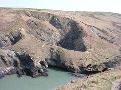
I have now finished the Pembrokeshire Coast Path, and I must admit that I will miss it. The scenery on the path is fantastic, and even the area around the oil refineries at Milford Haven was quite interesting, if not particularly scenic. The Pembrokeshire Coast has been the best stretch of coast that I have seen so far on this trip, and although I could have that impression due to the bright sunshine that has followed me for the last fortnight there is little doubt that it is a spectacular stretch of coastline. All the stiles on the path are numbered, and over the last ten days I have been counting them down, so when I reached stile number one near Allt-y-goed farm it was well worth taking a photograph of.
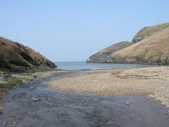
I stopped by the beach at Ceibwr Bay so that I could have my lunch. I also used the opportunity to take off the strapping that was on my right ankle, as it was getting hot and was annoying me. This beach was lovely, and the only bad point was the anticipation of the big ascent to come. There were lots of people about, as the beach has road access, and I enjoyed chatting to some of them as they came past me, and some were kind enough to give me donations. As I descended from the highest point of the cliffs near Cemaes Head I ran out of water, but fortunately the path soon joins a road which it follows for the descent down to the car park at Poppit Sands, so I did not have to exert myself too much. The car park at Poppit Sands was very busy, and I nipped into the cafe where I bought myself a bottle of water and treated myself to a Cornetto. I met Sam at the end of the Pembrokeshire Coast Path in St Dogmaels, and we walked together the rest of the way to the B&B in Cardigan.
To celebrate my birthday Sam had booked me into a B&B in Cardigan, and it had been our intention to go out for an evening meal. On the way up the hill to the B&B Sam bought a bottle of champagne, and when we got into the room we opened it before having showers. The champagne went straight to our heads, and afterwards neither of us could be bothered to go out. Tomorrow morning we are going to be having a cooked breakfast, and therefore I am not too bothered about skipping a meal. It feels exceedingly strange to spend the night in a proper bed, and I could not help but sprawl out in it as I slept, much to Sam's annoyance!
Tomorrow I am back to having to devise my own routes once again, now that the waymarked coast path has finished. I shall probably get to Llangranog, which is to the east of Aberporth, but this very much depends on what time I set off and the terrain, which looks as though it could be steep and difficult in places (although it is always hard to tell from an Ordnance Survey map).
Directions
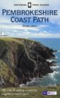
| This walk follows the Pembrokeshire Coast Path, the route of which is detailed in the Ordnance Survey National Trail Guide 7, Pembrokeshire Coast Path (ISBN 1-85410-770-4). Unfortunately the route description is written in reverse to the direction that I am walking, but the 1:25,000 maps in the book are clear and the signs on the ground are very good. Please click on the image to the right to go to the Amazon page for this book. |
 |
From the end of the Pembrokeshire Coast Path at the landing stage to the north of St Dogmaels continue on down the B4546 road southwards into the village, and then follow it as it turns to the left to head eastwards for a mile towards Cardigan. Cross the first bridge over the river and pass the castle before heading uphill along the main street. Immediately past a school turn left to join the B4548 road, and the B&B was a short distance along this road to the left.
Distances
| From | To | Distance (m) | Ascent (ft) | Descent (ft) |
|---|---|---|---|---|
| Newport | Ceibwr | 8.3 | 1854 | 1831 |
| Ceibwr | Cardigan | 9.2 | 1703 | 1601 |
This makes a total distance of 17.5 miles, with 3557 feet of ascent and 3432 feet of descent.
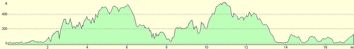
For more information on profiles, ascents and descents, see this page
Accommodation
we spent the night at the BrynhyFryd Guest House, at Gwbert Road, Cardigan, Ceredigon, Wales SA43 1AE. They can be contacted on (01239) 612861. This cost us forty pounds for the night, and seemed luxurious after the many months that we had spent sleeping in Mervan. The breakfast in the morning was very nice and filling, and everything was clean and tidy, which is more than can be said for some B&B's.
Disclaimer
Please note that I take no responsibility for anything that may happen when following these directions. If you intend to follow this route, then please use the relevant maps and check the route out before you go out. As always when walking, use common sense and you should be fine.
If you find any information on any of these routes that is inaccurate, or you wish to add anything, then please email me.
All images on this site are © of the author. Any reproduction, retransmissions, or republication of all or part of any document found on this site is expressly prohibited, unless the author has explicitly granted its prior written consent to so reproduce, retransmit, or republish the material. All other rights reserved.
Although this site includes links providing convenient direct access to other Internet sites, I do not endorse, approve, certify or make warranties or representations as to the accuracy of the information on these sites.
And finally, enjoy your walking!
This walk was mentioned in the following routes:
| My walk around the coastline of Britain |
| Pembrokeshire Coast Path |
Nearby walks
| # | Title | Walk length (miles) |
|---|---|---|
| 391 | Strumble Head to Newport | 18.9 |
|
|

|