Walk #393: Cardigan to Llangranog
 |
 |
|
General Data
| Date Walked | 24/03/2003 |
| County | Dyfed |
| Start Location | Cardigan |
| End Location | Llangranog |
| Start time | 09.12 |
| End time | 16.39 |
| Distance | 17.2 miles |
| Description | This was an enjoyable walk, although it was a bit of a letdown after the scenic joys of the Pembrokeshire Coast Path. |
| Pack | Today I carried my 30-litre Karrimor HotRock rucksack, which was filled with my packed lunch, waterproof leggings, water bottle and a couple of spare shirts, together with the usual assortment of odds and ends. |
| Condition | I am more or less okay after this walk, except for a pain in the side of my back after a little incident (see below). I had little problem with either of my ankles, and I found that these were both better than they have been for the last few days. |
| Weather | Last night it rained, the first rain that we have had for some time. By the time I started the walk this had cleared away, leaving only wet rooftops as a signal that it had been. The morning started cloudy but this dissipated during the morning, leaving a clear and sunny afternoon. It got quite hot in the afternoon, and there was not much wind to help cool me down so I was forced to take my coat off as the temperature rose. |
| OS map | Landranger number 145 (Cardigan & Mynydd Preseli) |
 |
 |
|
 |
Map of the walk
Maps courtesy of Google Maps. Route for indicative purposes only, and may have been plotted after the walk. Please let me have comments on what you think of this new format. For a detailed table of timings for this walk, please see the table file.
Notes
I walked down from the B&B in which we stayed last night into the centre of Cardigan, so that I could but a birthday card for a friend from W.H. Smiths when it opened. Because of this I started the walk from the bridge in Cardigan rather than from the B&B, where I finished yesterdays walk. The centre of the town was busier today than it had been yesterday evening, and it was bustling with the shops getting ready to open or another week.
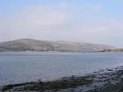
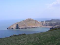
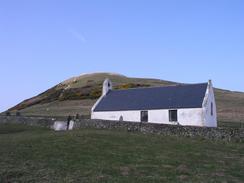
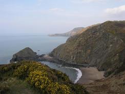
I needed a combination of road and footpath walking to get through Gwbert and the curiously named Y Ferwig to reach the lovely headland of Mwnt. The rocky headland towers above the tiny whitewashed Church of the Holy Cross, which was beautiful. The thirteenth century church is more spacious inside than it appears on the outside, and has rood stairs and some wood from a rood loft on display on the wall. The headland itself is quite curious; there is a deep channel between it and the mainland, which apparently has been formed by the erosion of glacial material deposited in a glacial valley. When you look at the deep channel you cannot help but think that eventually the headland will become an island as the rest of the material gets eroded away.
I was walking through the farm at Nantycroy I could hear a bull bellowing away within a gated area of the yard. A farmer came out and asked me what I was doing, and after I explained we chatted away for a few minutes. He explained that the bull was used as a guard bull, and it bellowed whenever anyone entered the yard. He told me not to keep to the footpath through the yard, but to cut across a field as the track was flooded and not very walkable. It is unusual to see a farmer who advocates climbing over gates, but I thanked him as I did not fancy wading through the mud and water.
I had a strange and quite perverse incident whilst crossing farmland along a footpath near Ffrwdwenith. The footpath crossed a field boundary via some stone steps into a field that contained a large black horse. I had got about twenty yards into the field when I had a heavy impact on my right-hand side that sent me sprawling onto the ground. This was very disconcerting, and as I lay on the ground I could see the horse standing above me with it's nostrils flaring. As I had entered the field I had obviously spooked the horse, and it had run up from behind me and whacked me with its left flank. I realised that I was in quite a delicate position with the horse above me, and so I started speaking to it. After a minute it backed away and I picked myself up, but it ran around me and started running up from behind me once more. This time I was prepared for it and I sidestepped as it passed me, before it pulled up and faced me. I started speaking to it once again as I looked at it, and after a couple of minutes it started eating grass. I saw this as an opportunity to move, an as I did so the horse paralleled me, escorting me across the field. I have no idea why I spooked the horse, although the walking poles strapped to my poles may have been the cause.
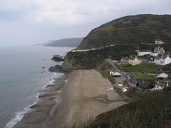
I met Sam in Mervan at a car park in Aberporth having dropped down from the hillside past the DERA missile base. She had kindly made me my lunch, and as I ate the sandwiches she massaged my back, which was aching after the fall. This seemed to do the trick, and it did not ache for the rest of the walk, but it restarted when I was back in the van this evening. I really did not feel like doing any more walking today, but I had done less than eleven miles and I really did not want to leave it there. I am glad that I did not, as the rest of the walk was quite spectacular, especially the last stretch down to the lovely beach at Llangranog.
We went for a quick drink this evening in the Ship Inn, which is right next to the car park that we parked in. The pub was quite welcoming, and although it had football playing on the television (Cardiff versus Newport) I enjoyed the short stay, especially because of the roaring fire and the lovely pint of 6X that they had on, the best and smoothest pint that I have had for some time.
Tomorrow I will be able to walk further northeastwards along the coastline, perhaps getting past Aberaeron to Aberath. The paths look quite easy going once I get past New Quay, although the first section could be quite steep in places, and due to lack of footpaths I may need to do a fairly long stretch along roads.
Directions
This walk starts at the first bridge over the river in Cardigan. Head uphill from the bridge into the town, and take the first road off to the left, which leads past a Somerfields store where it turns to the right and heads northwards, paralleling the high street. Cross over a crossroads and continue on to a car park, from where a road curves uphill to the left. Follow this road uphill as it heads past some playing fields and continues on northwestwards towards a farm. Before the farm is reached a footpath leads off to the right; this leads across fields before ending at the B4548 road. Turn left along the road and follow it as it climbs uphill for about a mile and a half until it reaches Gwbert.
In Gwbert the road turns to the right and heads uphill (it is no longer the B4548) to head eastwards into Y Ferwig. In this village turn left along another road that heads northwards, passing the farms at Penfeidr and Hafod before the public road ends. Here turn right down a track that leads through the farmyard at Nantycroy and continues on, becoming a footpath as it passes the farm at Clos-y-graig and reaching the road at Mwnt. Turn left along the road and follow it as it swings around a couple of hairpin bends and enters a caravan park at Ty Gwyn. Continue on along the footpath through the park and head uphill with a little valley on the right. The footpath eventually meets another track and continues uphill for a short distance until a road is met.
At the junction turn left and head eastwards along this road for a little over a mile until it turns sharply to the right, where a footpath continue straight on to the east. The path passes to the south of a ruined farm before heading to the south of a cottage (the OS map incorrectly shows this as heading north of the cottage). The path meets a track that it follows around to another farm, and again the route is different to that shown on the OS map. Head through the farm and head eastwards along another footpath that eventually ends at a driveway that leads northwards into the DERA Aberporth base. Turn right down the driveway for a couple of hundred yards until it ends at a public road. Turn left down this road as it skirts the southern edge of the base, before taking the first road to the left that heads steeply downhill and into Aberporth.
Head past a little car park with a statue of a dolphin beside it and descend onto the beach, from where a footpath zigzags uphill into the town (this path was shut for repair when I passed it, so I had to walk along the main road instead). At the top of the hill head north along a road before turning east along another road that leads to the end of the cliff top footpath. Join this footpath and follow it as it heads eastwards for a couple of kilometres until it finally descends down into Tresaith. From here if the tide is out you can walk along the Penbryn Beach for a mile to Penbryn; the tide did not allow this when I passed so I had to follow the road as it turned uphill southeastwards and swings around. Take a road that heads off to the left and passes to the west of a standing stone before shortly ending at a junction. At this junction continue downhill, passing the church at Penbryn before descending further and ascending once again on the other side of the valley. Take the first road to the left that leads downhill towards the beach (if you walked along the beach from Tresaith, then head uphill from the beach).
Immediately beside a farm turn right to head uphill to the north. The track curves round to the left before it reaches the top of the hill, and as it meets the top of the cliff a footpath leads off to the left, before a large Ariel is reached. Follow the footpath as it heads northeastwards, descending steeply down into a little valley near Castell Bach before heading uphill on the other side onto the cliff top once more. The final descent than starts, leading downhill to the road and finally the beach in Llangranog, where this walk ends.
Distances
| From | To | Distance (m) | Ascent (ft) | Descent (ft) |
|---|---|---|---|---|
| Cardigan | Aberporth | 12.0 | 1437 | 1522 |
| Aberporth | Llangranog | 5.2 | 1286 | 1296 |
This makes a total distance of 17.2 miles, with 2723 feet of ascent and 2818 feet of descent.
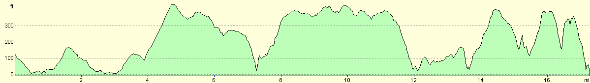
For more information on profiles, ascents and descents, see this page
Accommodation
We parked Mervan in the seafront car park in Llangranog, which as near to a pub and some public toilets. Unusually there were no signs saying that we could not park here overnight, so we decided to make the most of it.
Disclaimer
Please note that I take no responsibility for anything that may happen when following these directions. If you intend to follow this route, then please use the relevant maps and check the route out before you go out. As always when walking, use common sense and you should be fine.
If you find any information on any of these routes that is inaccurate, or you wish to add anything, then please email me.
All images on this site are © of the author. Any reproduction, retransmissions, or republication of all or part of any document found on this site is expressly prohibited, unless the author has explicitly granted its prior written consent to so reproduce, retransmit, or republish the material. All other rights reserved.
Although this site includes links providing convenient direct access to other Internet sites, I do not endorse, approve, certify or make warranties or representations as to the accuracy of the information on these sites.
And finally, enjoy your walking!
This walk was mentioned in the following routes:
| My walk around the coastline of Britain |
Nearby walks
| # | Title | Walk length (miles) |
|---|---|---|
| 392 | Newport to Cardigan | 17.5 |
|
|

|