Walk #124: Wells to Cheddar
 |
 |
|
General Data
| Date Walked | 25/11/2000 |
| County | Somerset |
| Start Location | Wells bus station |
| End Location | Cheddar YHA |
| Start time | 10.40 |
| End time | 15.10 |
| Distance | 11.3 miles |
| Description | This was a lovely walk over footpaths, mainly following the West Mendip Way, with a lovely climb up through Ebbor Gorge and onto the Mendip Hills. |
| Pack | Today I carried a large pack with no tent. |
| Condition | I feel okay after this walk. I have no blisters, but the underside of my feet ache a great deal. I was wearing my Salomon X Adventure 7's, so this is not too surprising. Unfortunately I am rather fatigued, and rather more so than I would have expected. This could have been due to both my lack of recent walks and the very muddy conditions underfoot. I also took no rests during the walk which could not have helped. My right shoulder aches a little as well, which is annoying. |
| Weather | Whilst I was walking early on it was mostly spitting with rain, although it soon started raining heavily whilst I was climbing up the spectacular Ebbor Gorge. This stopped when I reached the top, and was replaced with more spitting rain. As I started the descent down into Draycott it stopped and the rest of the afternoon was quite bright. The wind was fierce al day, especially on the exposed tops above the Ebbor Gorge. |
| OS map | Landranger number 182 (Weston-super-Mare, Bridgwater & Wells) |
Map of the walk
Maps courtesy of Google Maps. Route for indicative purposes only, and may have been plotted after the walk. Please let me have comments on what you think of this new format. For a detailed table of timings for this walk, please see the table file.
Notes
If I had to describe today in a word, that word would be "muddy". All the fields were waterlogged after the record-breaking wet autumn, and in so many places the paths were nothing but churned-up mud. In places this made the going very difficult indeed, as I seemed to be taking two steps forward and one slip backwards when going up the hills.
The weather was also not very good, particularly on the early parts of the walk. There was a fierce shower on the way up Ebbor Gorge, but fortunately my waterproofs kept me dry. Unfortunately at one stage of the walk I managed to somehow rip the left leg trouser bottom of my waterproof leggings, although I have absolutely no idea how I did this. It is a shame as I have not worn them that much yet, and I am a bit disappointed that they ripped so quickly.
I arrived in Cheddar a couple of hours before the YHA opened, so I dropped off my gear, changed from my boots into my trainers and voyaged down to a pub in Cheddar were I had a massive bacon, lettuce and tomato baguette along with a pint. I also watched Australia play the All Blacks in the Rugby final (Australia won, which made my girlfriend happy), and wrote these notes. All in all a most pleasant end to the day.
Ebbor Gorge is very spectacular - it is the remains of a dried-out river valley, and although not as nice as, for instance, Chee Dale in Derbyshire, it is nonetheless very impressive. At the end of the Gorge as it steepened and becomes narrower between the cliffs and slipper it is exceedingly nice, although it was very hard going on the slippery, polished rocks.
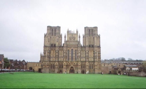
It is years since I was last properly in Wells (the last time was in August, when completing the walk from Taunton, but I went straight to the bus station and did not visit the Cathedral). The last time before that was when I was a child, during a visit to Weston-super-Mare. It was very nice to see the Cathedral and the very impressive buildings around it again. Indeed the whole town is very nice, with some of the widest gutters that I have ever seen. It was very busy with shoppers on this Saturday morning, and the main street was bustling. I called into the Tourist Information for a quick look around before heading off for the bus station.
Tomorrow I have to tackle a large climb up onto the cliffs above Cheddar Gorge first thing, followed by a descent back down to the road and another climb back onto the Mendips. This promises to be strenuous but should nonetheless be highly enjoyable.
Directions
This walk follows the West Mendip Way for most of the day; indeed, it is possible to follow it all the way to Cheddar, but due to the muddy conditions I took a short cut for the last mile or so.
Turn right out of the bus station to the end of the road and turn left. Turn right down St Cuthbert Street and continue as it becomes High Street. Turn left up Sadler Street and at the end turn right down New Street. This road soon end at a junction with The Liberty Road - continue straight on until you meet another road junction. Turn left down Mountery Road (the A39) until you are in between two schools on the right.
Head down a path that leads between the two schools; it then crosses Ash Lane and starts to head uphill, initially along Fir Tor Avenue, but this soon ends and it joins a surfaced track. This then passes a quarry. Here the road has been shut due to the risk of subsidence, so the Way goes into the field to the right for a short distance. It emerges onto the road again at a junction, with a road heading uphill beside another face of the quarry, a road heading off to the right and a track heading straight on. The Way heads off to the left a short distance into the road that is straight ahead.
This path heads uphill through some woodland before flattening out and joining the track that headed uphill past the quarry. Follow this track downhill as it becomes Lime Kiln Lane and when it turns to the left take a footpath that heads downhill and across a very muddy area and to Wells Road in Wookey Hole.
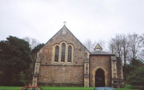
Follow the road northwards through Wookey Hole past the church and the pub. It then curves round to the left past the entrance to the caves and then joins another road. Turn right down this road and then take a left up a footpath.
This footpath heads up through Ebbor Gorge, a lovely stretch of walk, even in the rain. The path through the gorge becomes steeper and steeper until eventually it becomes a bit of a scramble through a narrow cleft in the rock. After the climb the path leaves the valley and heads off up the valley side to the right. It then heads across the edge of a couple of fields to Higher Pitts Farm.
Join the driveway past the Farm, and continue on it as it bends very sharply to the left. The track then heads south-northwestwards for half a kilometre before it becomes a path. This path then bends to the north and follows between two hedges for a short distance. The path then follows the hedge across another field, and when a hedge is reached turn left and follow this to a road.
Turn right down the road and follow it for just over half a kilometre into the nice little village of Friddy. At the village green turn left past the pub and head straight on up the hill past the Batch. At the top of the hill where a road heads off downhill take a footpath that leads through a field to the right before joining with another road again.
When this road ends at a T-junction take a footpath directly opposite the junction. This path heads westwards past an area dotted with many tumuli for about two kilometres before starting a steep descent downhill. About two-thirds of the way down the hill the path becomes a paved track, and later on a road. This road then joins up with the A371.
Turn right down the A371 and head through the village. Pass to the left of a church and take Top Road that passes uphill to the right. A road joins this one after a short distance, and at this point a path heads steeply uphill to the left. This path is the West Mendip Way, and I did not follow it and kept on the road. Follow this road as it contours the hillside, rising up slightly to a maximum altitude 50 metres. This then progresses to Bradley Cross.
At Bradley cross the road becomes Bradley Cross Lane and descends down into Cheddar, becoming Redcliffe Street on the way. At a T-junction with Cliff Street turn left to the village cross, and then turn right and follow the A371 for a short distance past a hotel. Take a right up The Hayes past a school. Cheddar YHA is up Hillfield Lane to the left beside the school, opposite the fire station.
Distances
| From | To | Distance (m) | Ascent (ft) | Descent (ft) |
|---|---|---|---|---|
| Wells Bus Station | Wookey Hole Inn | 2.3 | 312 | 249 |
| Wookey Hole Inn | Priddy | 3.2 | 702 | 105 |
| Priddy | Draycott Church | 3.4 | 167 | 801 |
| Draycott Church | Cheddar YHA | 2.4 | 112 | 213 |
This makes a total distance of 11.3 miles, with 1293 feet of ascent and 1368 feet of descent.
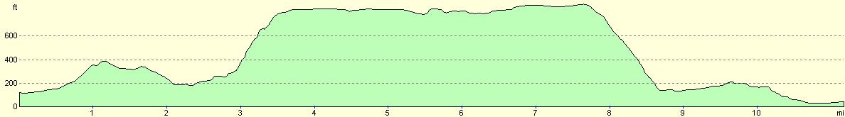
For more information on profiles, ascents and descents, see this page
Accommodation
I spent the night at Cheddar YHA, which was very nice and quite homely. I generally like these small YHA's as they have a better ambience than the larger ones. The people also seem to be so more friendly than the inner-city ones like Bath, which I stayed in last night.
Disclaimer
Please note that I take no responsibility for anything that may happen when following these directions. If you intend to follow this route, then please use the relevant maps and check the route out before you go out. As always when walking, use common sense and you should be fine.
If you find any information on any of these routes that is inaccurate, or you wish to add anything, then please email me.
All images on this site are © of the author. Any reproduction, retransmissions, or republication of all or part of any document found on this site is expressly prohibited, unless the author has explicitly granted its prior written consent to so reproduce, retransmit, or republish the material. All other rights reserved.
Although this site includes links providing convenient direct access to other Internet sites, I do not endorse, approve, certify or make warranties or representations as to the accuracy of the information on these sites.
And finally, enjoy your walking!
This walk was mentioned in the following routes:
| My sectional Land's End to John O'Groats walk |
Nearby walks
| # | Title | Walk length (miles) |
|---|---|---|
| 103 | Langport to Glastonbury | 11.3 |
| 104 | Glastonbury to Wells | 7.2 |
|
|

|