Walk #103: Langport to Glastonbury
 |
 |
|
General Data
| Date Walked | 06/08/2000 |
| County | Somerset |
| Start Location | Langport |
| End Location | Glastonbury |
| Start time | 08.00 |
| End time | 13.55 |
| Distance | 11.3 miles |
| Description | This was a fairly boring day of road and track walking across the Somerton Levels into Glastonbury. |
| Pack | Full Pennine-Way spec kit. |
| Condition | The underside of my feet really ache, and did for most of today's walk. This is very annoying as the rest of me is still fine (no aching shoulders, back troubles etcetera). It appears as though my boots, whilst ideal for boggy ground, are not meant for mile upon mile of road walking. The rashes on the inside of my thighs are slightly worse. I will again treat them with Vaseline and see what happens. |
| Weather | The weather today was not as hot as yesterday, or as sunny. There was full cloud cover at first, which only slowly started to clear. At the end of the walk there was still about 70% cloud cover. There was also more wind than yesterday, which helped keep me cool. |
| OS map | Landranger number 193 (Taunton & Lyme Regis, Chard & Bridport) and Landranger number 182 (Weston-super-Mare, Bridgwater & Wells) |
 |
 |
|
Map of the walk
Maps courtesy of Google Maps. Route for indicative purposes only, and may have been plotted after the walk. Please let me have comments on what you think of this new format. For a detailed table of timings for this walk, please see the table file.
Notes
A very tiring day on what should have been an easy day. The weight of my pack did not bother me as much as yesterday, but my feet hurt more.
I spent ninety minutes in Street so that I could have a rest and had a couple of pints and a Sunday lunch, which came in very handy. Street is quite a nice little town, dominated by Clarke's Village, which is now a series of retail outlets but was a manufacturing centre. The time I spent in the pub allowed me to take my boots off and wait for my feet to recover.
Glastonbury is a weird place, full of hippies and people with colourful and varied clothing and hairstyles. This is not really my sort of scene, but they all looked as if they were having a good time and enjoying themselves.
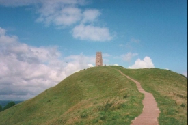
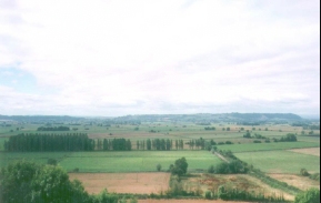
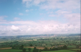
After I reached the campsite (which is to the northwest of Glastonbury) I dropped off my pack and went into the town. As it was such a nice afternoon I decided to climb up Glastonbury Tor, which is quite a walk from the centre of town. However the views from the top of the Tor are fantastic and made the climb worthwhile, with great 360-degree views over long distances.
This morning I went wrong whilst trying to head down to Pitney Steart Brudge and ended up in the hamlet of Stout on the road to High Ham. Fortunately this mistake was not as bad as it should have been due to a farm track that took me down to the bridge by a different route, but it was an annoying mistake to make nonetheless. Yet again I prove my old adage that navigation on he hills is far easier than in lowland areas.
The long stroll along the road and track leading north across Somerton Moor from Pitney Steart Bridge was boring, and the initial section along the track was laden with seemingly thousands of biting insects, and was tough on the feet and ankles as well due to the rough and uneven ground underfoot.
The lady owner of the campsite is apparently appearing on television next Thursday. A while back her husband bought her some driving lessons as, although she has been driving for twenty-five years, she could not reverse park. He placed a birthday advert in the local paper, and from there the story got into the Sun, Mirror, Daily Mail, and next Thursday, onto television.
This campsite is very nice - it has won the regional heats for the "best Caravan and Campsite toilets" for the last few years running, and it shows. It is really nice having a blazing hot shower in a clean shower block for a change.
Directions
Leave the Bowdens campsite and turn right to join the road. Follow Bowdens Lane to the east, passing a large transmission mast on the way. Follow the road as it swings around to the north and descends to cross Mill Brook before rising steeply past a navy firing range. At the next T-junction turn right and then immediately left to head north into Low Ham past the church.
Continue on northwards through the village and out into Bramwell. At the road junction continue on as the road turns to the northeast, and then take the next right turn which leads over a stream called Leazemoor Rhyne and then shortly afterwards turn left up another road. Follow this road into the hamlet of Park, and at ST451301 turn left to head north to Pitney Steart Bridge.
From the bridge take a track that leads off to the half-right, and follow it as it bends round to head directly northwards across Somerton Moor. After about one and three quarter miles the track ends at a bridge, and continues as a road to the north-northeast. After a couple of kilometres a T-junction is reached with another road.
A footpath leads up Walton Hill immediately opposite the junction, which leads onto a road at the top of the hill near an old windmill which is without it's sails. Turn right onto the road and ascend the hill, and then take the first left down a road. Follow the road as it turns to the right, and as it turns to the left take a track that leads off to the right. Head up this track for a short distance and then take a footpath that leads off to the left across some fields. Another road is soon met, which you turn right along for a very short distance before taking another footpath to the left. This footpath leads eastwards across fields and through a wood, before exiting onto a housing estate in Street.
Go through the housing estate and head eastwards through Street. Join the High Street and follow it northeastwards through the town. When you reach a T-junction with the B3151 turn left and follow it to a roundabout with the A39.
Follow the A39 northwards. There is a good footpath on the right-hand side of the road which means that this is not a very dangerous maneuver. The A39 crosses over The River Brue and heads north. On the bridge cross over to the pavement on the left-hand side of the road, and then take the first road to the left after the bridge (at ST486378). This road soon bends to the right and heads northwestwards past abandoned industrial buildings to the Beckery. Continue straight on here until you reach the B3151 road. Cross over this road and continue on. The Isle of Avalon campsite, where this walk ends, is on the left-hand side of this road.
Accommodation
I stayed at the Isle of Avalon campsite, which is just to the northwest of the centre of the town.
Distances
| From | To | Distance (m) | Ascent (ft) | Descent (ft) |
|---|---|---|---|---|
| Bowden's Campsite | Walton Hill | 7.1 | 279 | 361 |
| Walton Hill | Glastonbury | 4.2 | 112 | 246 |
This makes a total distance of 11.3 miles, with 391 feet of ascent and 607 feet of descent.
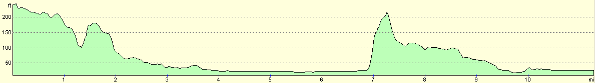
For more information on profiles, ascents and descents, see this page
Disclaimer
Please note that I take no responsibility for anything that may happen when following these directions. If you intend to follow this route, then please use the relevant maps and check the route out before you go out. As always when walking, use common sense and you should be fine.
If you find any information on any of these routes that is inaccurate, or you wish to add anything, then please email me.
All images on this site are © of the author. Any reproduction, retransmissions, or republication of all or part of any document found on this site is expressly prohibited, unless the author has explicitly granted its prior written consent to so reproduce, retransmit, or republish the material. All other rights reserved.
Although this site includes links providing convenient direct access to other Internet sites, I do not endorse, approve, certify or make warranties or representations as to the accuracy of the information on these sites.
And finally, enjoy your walking!
This walk was mentioned in the following routes:
| My sectional Land's End to John O'Groats walk |
Nearby walks
| # | Title | Walk length (miles) |
|---|---|---|
| 102 | Taunton to Langport | 15.9 |
| 104 | Glastonbury to Wells | 7.2 |
|
|

|