Walk #751: A circular walk around Grafham Water
 |
 |
|
General Data
| Date Walked | 27/11/2006 |
| County | Cambridgeshire |
| Start Location | Spaldwick |
| End Location | Spaldwick |
| Start time | 08.12 |
| End time | 15.10 |
| Distance | 20.0 miles |
| Description | This was an interesting walk in Eastern Cambridgeshire, including a circuit around Grafham Water. |
| Pack | Today I carried my 30-litre Karrimor rucksack filled with my waterproofs, two litres of water, and various other odds and ends. |
| Condition | I was not very well on this walk - I had some chest pains and I had trouble with the toes on my right foot. A very disappointing day. |
| Weather | The day was overcast with some sunny periods, and reasonably mild for the time of year. |
| OS map | Landranger number 153 (Bedford & Huntingdon, St Neots & Biggleswade) |
 |
 |
|
 |
 |
|
Map of the walk
Maps courtesy of Google Maps. Route for indicative purposes only, and may have been plotted after the walk. Please let me have comments on what you think of this new format. For a detailed table of timings for this walk, please see the table file.
 |
 |
|
 |
 |
|
Notes
For some time I had been planning to do a walk around Grafham Water, a reservoir fairly close to me in Cambridgeshire. As the reservoir is only ten miles around, I had planned an extended walk to make it around twenty miles, and early this morning I set off, as I did not want to drive too far. I therefore pulled up in the pretty little village of Spaldwick shortly after eight, and as schoolchildren were waiting for their bus to school I got all my kit ready for the walk.
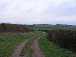
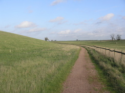
It felt fairly cold once I set off, and as I walked through the village I tried to walk faster to warm myself up. The spire of the church is attractive, but the sun was too low and in the wrong direction to get any good photographs - these would have to wait until I got back in the afternoon. After a short distance I found myself on a broad track that descended down a slight hill, with a car yard on the other side of the hedge to my left. The track made for a pleasant walk, and although it was still chilly I was starting to warm myself up well. Unfortunately the second toe on my right foot soon started hurting, and this continued to bother me through the rest of the day.
The track continued on, passing under some power lines before becoming more of a footpath than a track before ascending up Bunkers Hill. The skies were still blue, and before I knew it I was passing a house on the left and reaching a main road. This was the furthest west that I would be travelling on today's walk, and after following the road for a few yards another footpath took me back southeastwards, a pleasant if muddy walk. Off to the right there was the an old railway line marked on the map, but I never really saw any trace of it on the ground.
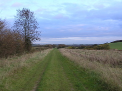
I soon found myself on a road in Stow Longa, which has a strange village sign - a three dimensional one including a model of a steam locomotive and the church. It was a pleasant place, with a few thatched housed dotted about. I followed the road for a short distance, before taking a bridleway that headed out of the village, and from which there were some good views over to the north. Towards the end of the bridleway there was a farm and a deserted, ruined farmhouse, which looks like it is well situated to be converted into a house.
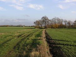
A road walk followed towards Easton, after which a bridleway took me away from the road, following the Three Shires Way, towards Grafham Water. The path was muddy in places, and this got far worse as the path ascended up through some trees, and I had to walk onto the wide verges of the track to avoid slipping down. The track only slackened for a short period, before descending down to pass under an old railway bridge, part of the old Huntingdon to Kettering railway line.
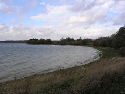
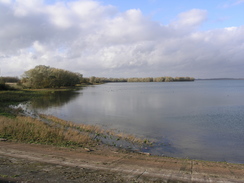
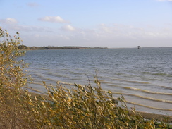
From here it was a short distance down to the side of the reservoir, which was glinting beautifully in the sunshine. Sticking out of the water near this northern bank there was a large tower, and I enjoyed the stroll as it headed down to a car park. Here the path left the reservoir and headed uphill past a farm, before heading back to the side of the reservoir via a footpath. The next stretch of path was an enjoyable stroll, although in one place it had been badly eroded and it took a little care to get past.
Eventually I decided to leave the footpath and joined the cycle path instead, which circuits the reservoir but takes a less waterside route, running around the periphery. This led me on to the exhibition centre, and after using the toilet I was glad to find that the cafe was open. After ordering a bacon sandwich and sitting down, I took my right boot off and removed one sock, hoping that this would relieve the pain coming from my toe. The only other people in the cafe were a couple of Nuns, and I stared at the map as I waited for my sandwich to come.
Once I had set off again my toe continued to hurt, although it was not as bad as it had been, and the cycle path headed towards the long reservoir dam. Unfortunately there were sings stating that the public cannot walk over this, and so I followed the cycle path as it took a lower and far less scenic route below the dam. When I was halfway along I saw a couple walking along the top of the dam, and so I assume that either you are allowed to walk along the top, or people do so anyway. Near the end of the dam I climbed up the bank in order to take a few photographs of the reservoir, before joining a rack that ran towards a car park.
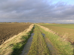
The path along the southern end of the reservoir towards the twin villages of East Perry and West Perry was fairly boring, and there were not many views to be had over the reservoir at any point as the path either ran alongside or parallel to the main road. In East Perry there is a large water works, and as I passed through West Perry I chose not to go into the pub, and instead continued on along the cycle path. This led me to another car park near the water's edge, and after having left the road the walk became better, with more views over the water.
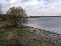
When the path headed uphill I diverted of along another path that stuck to the water's edge, going through a small patch of woodland before reaching an open area, with a relatively expansive views along the length of the reservoir, before climbing back up to meet the cycle path once more. The walk along the western side of the reservoir allowed me scant glances of the water, and passed through several nice areas of pine woodland, with a light scent of pine hanging in the air. Unfortunately the path also paralleled a couple of power transmission lines, and these intruded onto the walk for long periods.
Eventually the path descended down to meet an inlet at the northwestern edge of the reservoir, and as I descended a unicyclist came past me, sweating hard but balancing perfectly as he expertly sped past me. From here the path stuck to the northern edge of the reservoir, and was a very enjoyable walk, with good views over the water. By this stage I was starting to feel slightly ill, and as I strolled on this slowly got worse, with pains in the left-hand side of my chest. It was a relief when I reached the point where I had joined the path around the reservoir, and passed under the railway bridge and headed back along the track towards the road.
Shortly after slipping and sliding down the muddy bank I started to feel short of breath as the pain in my chest increased, and after a few of minutes I had to stop as I found myself gasping for breath. I rested for a couple of minutes before carefully heading on along the flat track, feeling ill and nauseous, with sharp pains racking my chest. Eventually I made my way to the road, and on the flatter ground managed to make reasonable time towards Easton.
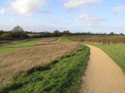
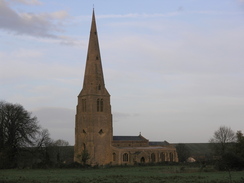
The highlight of this village is the church, which is small but perfect, with a tall and thin spire that seemed to endlessly reach up for the sky. Still feeling discomfort I walked around the church, and then headed back to the road to pass an attractive large thatched house. A green lane took me onwards back towards Spaldwick, and I took my time on the level terrain, trying not to stress myself too much. It was another pleasant walk, and this helped take my mind off things, and before I knew it I had reached the road. I followed this back the short distance towards Spaldwick, and from there with relief walked past the church, which I managed to get better photographs of than I had this morning, and then back to my car and the village cross.
Grafham Water was very disappointing - the path along the southern edge of the reservoir was hardly worth doing, and only the northern bank was actually a really worthwhile waterside walk. Rutland Water is a far better walk, although far longer at 35 miles around it. This is a shame, and I hope that a better route around the reservoir can be made some time.
 |
 |
|
Directions
This walk starts off at the village cross in the middle of Spaldwick.Head northwestwards down Stow Road, with the church on the right, and follow it as it soon curves around to the right to head westwards. After a hundred yards the road curves once more to the left; here continue straight on down Mount Pleasant. This road soon ends at a metal gate; go past the gate and head down a green lane westwards, initially descending before levelling out. As time goes on the track becomes more of a path, and eventually kinks to the right slightly as it takes a more southwesterly course.
Eventually the path starts to climb once again, becoming a surfaced track at Holly Rose Lodge before ending at the B660 road. Turn left and walk south down the B660 for about a hundred yards until a footpath is reached on the left, just before a road junction is reached on the right. Follow this footpath as it heads initially southeastwards for about a kilometre, before curving to the left to take a more easterly course before ending at The Lane in Stow Longa. At the end of the lane turn left to head northeastwards up Spaldwick Road, and just after the 30 MPH signs are passed turn right along a bridleway that passes Manor Farm. The path initially follows a clear track, and when this ends a bridleway continues on southeastwards, kinking to the right and then almost immediately the left before ending at a road.
Turn left and follow this road as it heads northeastwards for a little over a kilometre, dipping down into a little valley and passing Sewell's Barn on the right. Soon afterwards a bridleway leads off to the right, signposted for the Three Shires Way. Initially the path follows a track and soon curves sharply to the left; it then heads on southeastwards, passing under three sets of power lines before curving to the right to climb up a short but steep hill. At the top the gradient slackens, and the path heads on before descending down to head under an old bridge under an old railway line and reach the edge of the reservoir.
Here turn left and start following the path that runs clockwise along the edge of the reservoir. Soon this reaches a car park, after which the path leaves the side of the reservoir and heads eastwards uphill along a road past Hill Farm. After about fifty yards the road turns to the left; just before this bend a footpath leads off to the right, heading back down to the water's edge. The path heads on along the edge of the reservoir, and eventually meets a cycle path that can be used to walk around the entire reservoir, aside from a short section alongside the B661 near East Perry. Follow the route around the reservoir, back towards the railway bridge at the northern edge.
Once at the railway bridge, retrace the steps from earlier in the walk following the Three Shires Way northwestwards back to the Kimbolton to Easton Road. Once at the road, turn right and follow it as it heads northeastwards towards Easton. The road soon curves sharply to the left before entering the village; when the road soon turns once more to the right continue straight on along Church Road. This curves to the right and then the left to pass the church, and after passing a large thatched house on the left continue straight on as the road curves to the right.
A clear track leads onwards, and is easy to follow as it heads northwestwards for about a kilometre towards Upthorpe Lodge. Eventually the track curves sharply to the right to head northwards for about a hundred yards, before curving to the left at a junction to head northwestwards to shortly end at a road to the south of Spaldwick by a bridge over a little stream. Turn right and follow the road northwards back towards Spaldwick, curving to the right and then the left to reach the village cross, where this walk ends.
Distances
| From | To | Distance (m) | Ascent (ft) | Descent (ft) |
|---|---|---|---|---|
| Spaldwick | Grafham Water Exhibition Centre | 9.6 | 410 | 322 |
| Grafham Water Exhibition Centre | Spaldwick | 10.4 | 371 | 459 |
This makes a total distance of 20.0 miles, with 781 feet of ascent and 781 feet of descent.
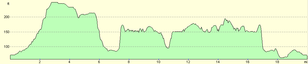
For more information on profiles, ascents and descents, see this page
Disclaimer
Please note that I take no responsibility for anything that may happen when following these directions. If you intend to follow this route, then please use the relevant maps and check the route out before you go out. As always when walking, use common sense and you should be fine.
If you find any information on any of these routes that is inaccurate, or you wish to add anything, then please email me.
All images on this site are © of the author. Any reproduction, retransmissions, or republication of all or part of any document found on this site is expressly prohibited, unless the author has explicitly granted its prior written consent to so reproduce, retransmit, or republish the material. All other rights reserved.
Although this site includes links providing convenient direct access to other Internet sites, I do not endorse, approve, certify or make warranties or representations as to the accuracy of the information on these sites.
And finally, enjoy your walking!
Nearby walks
| # | Title | Walk length (miles) |
|---|---|---|
| 108 | Waterbeach to Huntingdon | 21.6 |
| 119 | Huntingdon to St Neots | 11.8 |
| 120 | St Neots to Biggleswade | 13.0 |
|
|

|