Walk #750: Thames Path: Putney Bridge to Charlton
 |
 |
|
General Data
| Date Walked | 18/11/2006 |
| County | London |
| Start Location | Putney Bridge station |
| End Location | Charlton |
| Start time | 09.00 |
| End time | 16.29 |
| Distance | 21.1 miles |
| Description | This was a long walk, following the Thames Path through London to it's end at the Thames Barrier. |
| Pack | Today I carried my 30-litre Karrimor rucksack filled with my waterproofs, two litres of water, and various other odds and ends. |
| Condition | My right knee ached at time through the walk, but aside from this I had no problems. |
| Weather | The day was bright and sunny, with scarcely a cloud in the sky all day. Initially it was a chilly day, but it soon warme dup as the day went on. |
| OS map | Landranger number 176 (West London, Rickmansworth & Staines) and Landranger number 177 (East London, Billericay & Gravesend) |
 |
 |
|
 |
 |
|
Map of the walk
Maps courtesy of Google Maps. Route for indicative purposes only, and may have been plotted after the walk. Please let me have comments on what you think of this new format. For a detailed table of timings for this walk, please see the table file.
 |
 |
|
 |
 |
|
Notes
I had been able to plan the Thames Path so that I would finish with a pleasant 20-mile stroll to the end of the trail at the Thames Barrier. Although I had previously done the stretch from Westminster to the Barrier on the Coastwalk, and I knew the area in the East End very well, I was still looking forward to the walk. I drove down from Cambridge to Mile End, and then got the tube to Putney Bridge, and although engineering works on the District line changed my plans somewhat I still arrived in front of Putney Bridge tube station at nine, a surprisingly long two and a half hours after I set off.
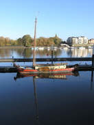
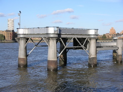
I crossed the footbridge beside Putney rail bridge to get to the southern bank of the river, and got some good views down the river - better than when I had walked across it the previous weekend in the dusk. On the other side a road took me to Wandsworth Park, which was happily busy with joggers and dog walkers. The next stretch through Wandsworth was confusing - new riverside developments have made the route marked in the guidebook redundant, and I made my own way through, until I reached a place where construction works blocked the way once more, and I had to double back for a short distance to find my way towards the waster transfer stations (where waste from the surrounding London boroughs is transferred onto barges to be taken elsewhere).
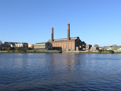
This led me to Wandsworth Bridge, and on the other side I was forces to divert inland along a busy road, before heading back to the riverside path, newly create by yet more new development. Unfortunately this did not last long, and the path soon diverted back inland along roads, passing a heliport before passing under Battersea rail bridge. On the other side of this the path rejoined the river, and there were some pleasant views over towards the Chelsea Harbour development and the dominating chimneys of Lots Road Power station, called a solid, functional, slab' in the Guidebook, but which I quite liked the design of - there are certainly far worse power stations, even in London. This was one of the main places where, until 2002, power for London Underground was generated. There are currently plans for it to be developed into shops and offices.
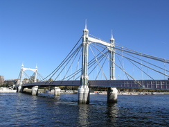
A pleasant riverside walk followed, passing the attractive 18th Century Church of St Mary before reaching Battersea Bridge and, a short distance further on, the slender Albert Bridge, a suspension bridge that opened in 1872, but with central supports mid-river built a century later to ease the strain on the cables under modern traffic loads. The bridge is very attractive, and I can see why it is one of the more famous Thames crossings.
On the other side of the bridge is Battersea Park, and the broad riverside path was again busy with dog walkers and joggers. After passing the London Peace Pagoda, an attractive but slightly incongruous sight, I found that the toilets halfway along the river were annoyingly shut. When the path reaches the edge of the park by Chelsea Bridge, the Trail turns right and follows the eastern edge of the park southwards. Instead of following the surfaced path I took a narrower path nearer to the road, but far wilder in character, to the Queen's Circus Gates, and headed out of the park onto a roundabout.
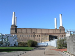
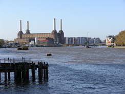
There was a petrol station that had toilets, and after this a road headed past the famous Battersea dogs and cats home, with occasional views over to the left towards the empty and roofless Battersea Power Station. The path soon left this road and wound around another road, passing an entrance to the power station, I asked a security guard if I could take some photos through the gates. Shortly after this the Trail rejoined the riverside, and followed this past some new developments towards Vauxhall Bridge.
On the other side of this bridge there is a pleasant area with some seating, and it initially hard to believe that the building slightly offset from the river is the headquarters of MI6. The security is all very low-key, and some of it has even been built into the way the riverside terrace joins the walls and fences, with trees adding to the ambience. It is certainly much more welcoming than bleak military-style fences would have been, and is an impressive sight. It was only when walking past the other side of the building that the security became obvious, with an access gateway guarded by fences and a revolving spiked door.
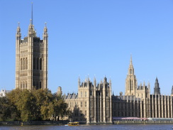
The riverside path led on to Lambeth Views, and views of the Millennium Wheel and the Houses of Parliament were occasionally seen. On the other side of the bridge the views of Parliament became even better, and I was on a stretch of path -the Albert Embankment - that I had walked on many previous occasions. Many people were out and about, walking along this most touristy stretch of riverside path, and I stopped to take even more photographs of the magnificent Gothic buildings on the other side of the river.
Westminster bridge is currently undergoing maintenance, and there were some workmen's portacabins elevated above the foreshore. The bridge marked the point where I had crossed the Thames on my coastwalk, and as I passed through the subway I got a warm, satisfied feeling - from here on I had walked the path downstream in 2002 during that walk, and I could therefore say that I had walked all of the Thames Path. I wanted to reach the official end of the way today, however, and as I headed north from the bridge I was surprised by how busy the path was - it was far busier than I have seen it before. This was probably due to the Dali Exhibition and the stunning Millennium Wheel, which I reached next. I have never had the opportunity to go on the wheel, but I will have to do so sometime - although I also remember saying this last time I was here.
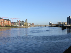
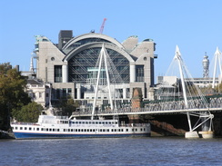
Hungerford rail bridge came next, although two pedestrian bridge were built a few years, one cantilevered off either side of the bridge. This is yet another sign of the revitalisation of the southern bank of the river, which is now more interesting than the northern bank. The Trail than passed the fairly ugly Royal Festival Hall to reach Waterloo Bridge, and the next stretch leading past they National Theatre was bustling, with people performing for money (including a fire breather), and knots of people huddled around watching.
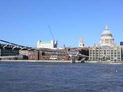
I was feeling really good by this time, and immensely enjoying the stroll. After passing under the twin Blackfriar's bridge (the road bridge first, followed by the rail bridge) the path passed the Tate Modern Gallery, fairly tastefully converted out of the old Bankside power station (designed by Sir Giles Gilbert Scott, who also designed Battersea power station), and onto the Millennium footbridge (also known as the Wobbly footbridge because of the stability problems that it had on opening). The bridge fits in quite well with St Paul's, visible on the north side of the river, and Bankside, and is a worthy (if expensive) addition to the riverside.
Before Southwark Bridge the reconstructed Shakespeare's Globe Theatre was passed, and on the other side the path passed the rather gaudy replica of Sir Francis Drake's ship, the Golden Hinde, and left the riverside to squeeze past Southwark Cathedral to reach London Bridge. The riverside was soon rejoined,and headed past HMS Belfast - a World War II big-gun warship, which is open to the public. It appeared to be in the process of being repainted, and the new colours reminded me of the way that some ships were painted gaudy colours to break up their outlines.
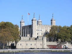
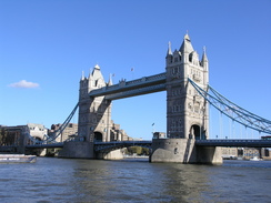
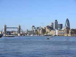
Shortly after this came the famous Tower Bridge, with the Tower of London on the other side of the river, and then came a pleasant walk along riverside paths eastwards, passing the Design Museum and then crossing an elegant footbridge over the entrance to St Saviour's Dock. I put the walk out of my mind as I walked into Rotherhithe, passing near to the station and the entrance to Brunel's tunnel, now a museum. This was the first underwater tunnel in the world, started by Marc Brunel and completed by his son, the infamous Sir Isambard Kingdom Brunel.
The trail crossed a red lift bridge over the entrance to Surrey Water, before curving past Lower Pool, where expansive views of Docklands ahead became dominant. The way that this area has changed over the last few years is amazing, and there are changed, even if less marked, on the southern side of the river. The riverside has been redeveloped, as if the skyscrapers on the other side of the river had pulled up the buildings on this side, and it was a pleasant walk southwards.
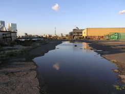
Unfortunately all good things have to end, and this was the case after the Trail passed the entrance to Greenland Dock, a fairly plush area, and reached the old buildings of the Deptford Naval Dockyard. This marked a diversion away from the river through Deptford, which was by far the most unpleasant stretch of the whole Thames Path. The roads were messy and undistinguished tower blocks overhung them. A typical scene was a well-appointed children's playground, which had an old sofa outside it on the pavement; a short distance later there were men drinking cans of lager in the little Sayes Green Park.
The trail rejoined the river at a new redevelopment near the entrance to Deptford Creek, and I breathed a sigh of relief at being into a better area, and in the company of the river once again. A slightly circuitous path took me to the bridge over the creek, and then on into the centre of Greenwich, using a route that must have opened fairly recently, as I had never walked it before.
The area around the Cutty Sark was closed off, part of a large project to conserve the composite built (wood on an iron frame) ship. The project will involve the ship being raised within the dry dock in which it sits, with an exhibition space being created underneath, along with much internal and external restoration. It only closed a fortnight before today, and it looked as though the work was only just starting. I was also bemused to see that the Gipsy Moth IV (the boat that Sir Francis Chichester sailed single-handedly around the world in 1966 to 67) had been removed, and is now actually sailing once more.
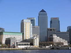
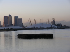
After passing the Cutty Sark, the Trail led on past the Old Royal Navy College, and the next half mile was fascinating, and also rather busy, the narrow path filled with people and cyclists. The Trinity Hospital almshouses were pretty, and then came the old Cutty Sark Pub. After this the path became more industrial but it was still a far more pleasant walk than the stretch through Deptford had been - there was more to see, and the views out across the river were always interesting. As the river curved to head northwards towards North Greenwich I got some views of the Canary Wharf complex, and on the other side of the river there was the blue lift bridge over the entrance to the docks on the Isle of Dogs - I had lived in a flat near there in 1993-4, and had thoroughly enjoyed my stay on the Isle.
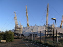
The Millennium Dome was a dominating sight as I rounded Niorth Greenwich, but it was one that annoyed me - the area around it looked like a construction site, and I am furious that the massively expensive structure is not yet in permanent use. Keeping a structure like that empty for six years must be costing a fortune, and I wish that they had built something that could have been more easily reused.
There were a couple of interesting scultpures on this stretch - 'Slice of Reality' by Richard Wilson is a short section of a large ship, including the bridge structure, which was a fascinating look (for me at least) into how they are constructed. The other was a strange metal structure on pillars out in the river, which apparently is called 'Quantum Cloud'. One major reason for constructing the Millennium Dome in Greenwich was regeneration, and although there were some new flats in the area, it did not seem as though the massive amounts of money spent had really been well spent - I wonder if, given that the Jubilee Line Extension would have been built anyway, the little regeneration that there has been would have occurred anyway?
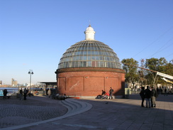
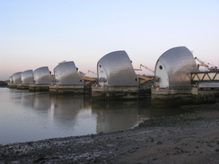
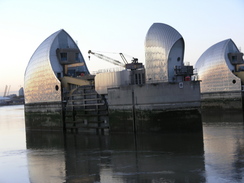
I used to live on the Isle of Dogs twelve or thirteen years ago, and in my time there I had walked extensively all over the East End, including to the Thames Barrier when it was closed to stop a tide surge. As I walked along the good path that led towards the barrier I got some superb views of it, and as the sun was starting to fall the silver covering over the barrier glowed orange in the low sun. It was a superb sight, and a brilliant way of ending a National Trail. I walked through the tunnel under the control building, and found a long profile of the entire Thames from the source to the barrier, drawn in a line on the concrete wall.
On the other side of the tunnel was the sign pronouncing the start of the path, and I found my mind wandering back to all of the previous times that I had been here, and realised that this was by far the most memorable. Of the trails that I was planning to do this year (the South Downs, the Ridgeway and the Thames Path), the latter has been very surprisingly the best - it has been a really easy and relaxing walk, but the way that the river changes from its source in the Cotswolds to the estuarine river in London was fascinating. At the start it was not even a trickle, and yet here it was, a full blooded river.
It was now getting darker, so after taking a few more photographs I headed off, walking up towards the main road, and then along this towards Charlton station. As I walked I noticed that there were many bus services running along the road towards Greenwich, so I jumped on one of these instead of waiting for a train.
It was a very satisfying feeling to have finished the Thames Path, and therefore another National Trail, and I had a nice warm sensation as I travelled on the bus back to Greenwich, where I took the DLR to Stratford and then the Central Line back to my car at South Woodford. Although I have done the Thames Path, I still want to come back and do the 30-miles of the northern bank from Teddington Lock to the Isle of Dogs, to have truly completed the whole path.
 |
 |
|
 |
 |
|
Directions
| The walk is also covered in detail in the Thames Path National Trail Guide, by David Sharp, ISBN 1-84513-062-6 published by Aurum Press Ltd. Click on the image to the right to go to the Amazon page for the book. The exceptions to this are at the start and end of the walk; firstly, the stretch of path from Putney Bridge station across the river, which is mentioned in the guidebook. At the end of the walk, when the Thames Barrier is reached head through the concrete tunnel to a picnic area with a bank on the right; turn right to climb over the bank, and then continue straight on southwards towards a car park. Go through the car park and follow Eastmoor Street southwards for a few hundred yards until it ends at the A206 road. There are bus servics from here towards Greenwich and Lewisham. If you want a train, then turn right to head west down the A206; immediately there is a roundabout; cross this and continue westwards, crossing another roundabout . At the next major junction with Anchor and Hope Lane on the right, turn left up Charlton Church Lane; Charlton station is a few yards away on the right. |  |
 |
 |
|
 |
 |
|
Distances
| From | To | Distance (m) | Ascent (ft) | Descent (ft) |
|---|---|---|---|---|
| Putney Bridge | Tower Bridge | 10.0 | 148 | 148 |
| Tower Bridge | Greenwich | 5.9 | 75 | 79 |
| Greenwich | Bus stop near Charlton Station | 5.2 | 75 | 56 |
This makes a total distance of 21.1 miles, with 298 feet of ascent and 283 feet of descent.
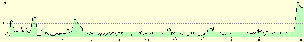
For more information on profiles, ascents and descents, see this page
Transport
Putney Bridge station is on the Wimbledon branch of the Distrcit line; the Thames Barrier is handy for bus services back towards Greenwich, or train services from nearby Charlton station.
 |
 |
|
Disclaimer
Please note that I take no responsibility for anything that may happen when following these directions. If you intend to follow this route, then please use the relevant maps and check the route out before you go out. As always when walking, use common sense and you should be fine.
If you find any information on any of these routes that is inaccurate, or you wish to add anything, then please email me.
All images on this site are © of the author. Any reproduction, retransmissions, or republication of all or part of any document found on this site is expressly prohibited, unless the author has explicitly granted its prior written consent to so reproduce, retransmit, or republish the material. All other rights reserved.
Although this site includes links providing convenient direct access to other Internet sites, I do not endorse, approve, certify or make warranties or representations as to the accuracy of the information on these sites.
And finally, enjoy your walking!
Nearby walks
| # | Title | Walk length (miles) |
|---|---|---|
| 50 | Paddington to Mile End | 8.3 |
| 51 | Mile End to Enfield Lock | 12.7 |
| 65 | Alperton to Paddington | 6.4 |
|
|

|