Walk #752: Great Shelford to Cambridge via Fulbourn, Lode and Horningsea
 |
 |
|
General Data
| Date Walked | 04/12/2006 |
| County | Cambridgeshire |
| Start Location | Great Shelford |
| End Location | Cambridge bus station |
| Start time | 08.24 |
| End time | 16.09 |
| Distance | 22.5 miles |
| Description | This was a pleasant walk around the eastern side of Cambridge, following the Harcamlow Way for much of the time. |
| Pack | Today I carried my 30-litre Karrimor rucksack filled with my waterproofs, two litres of water, and various other odds and ends. |
| Condition | COnsidering how poorly I felt after last Monday's walk, it was a very pleasant surprise to find that I had no significant problems during today's walk - it all seemd to go fairly swimmingly. |
| Weather | The day started off bright and sunny, with hardly a cloud in the sky, albeit rather chilly. As the day wore on into the afternoon the clouds started to gather and the winds got stronger, but there was never any risk of rain. |
| OS map | Landranger number 154 (Cambridge & Newmarket, Saffron Walden) |
 |
 |
|
 |
 |
|
Map of the walk
Maps courtesy of Google Maps. Route for indicative purposes only, and may have been plotted after the walk. Please let me have comments on what you think of this new format. For a detailed table of timings for this walk, please see the table file.
 |
 |
|
 |
 |
|
Notes
As the days are getting shorter I am starting to travel lee to get to my walks, and therefore I decided to do this walk this morning, which is the first one for nearly three years that starts at my doorstep. This was a walk that I had planned for some time, and after the health problems that I had on last Monday's walk it seemed like a good plan to choose a walk where there were lots of public transport options for me to cut the walk shorter if I needed to.
With bleary eyes I put my kit together and walked down to my car to put my boots on, before heading off up the road. The initial couple of miles of the day's walk are ones that I do regularly when I walk into work, and therefore I put myself onto autopilot as I strolled down the road towards the level crossing and made my way along paths and roads towards Shelford railway station.
Children were being taken to school as I walked towards the pretty Stapleford church, the three villages of Great Shelford, Little Shelford and Stapleford now being one homogeneous mass with no real indication of where one ends and the next begins. A path took me past a local school, and a very muddy one went through allotments to lead me towards a road that took me to Bury Farm.
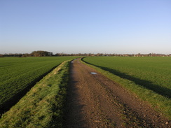
The next mile was very pleasant as a track took me eastwards; overhead there were bright blue skies, and although the immediate terrain was dead flat there were some good views over towards the tree-lined Magog Downs and Wandlebury Hill Fort, the only real high ground in the area. As it was a walk that I have done many times before there was not much for me to really note, but it was a highly pleasant walk nonetheless.
As the track crossed the River Granta via a concrete slab bridge I looked down at the water and was surprised to find that the river was fairly full and flowing fast - usually the river at this point is just a weed-filled trickle, and it was the first time this year that I had seen it this full. Another muddy track led on towards Babraham, but soon I left the route that I take into work and turned into an area of young woodland beside the track.
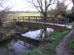
A pleasant walk through the woods took me to a footbridge that led back over the river, and from here a footpath headed on before ending at the A1307. This was busy at this time of the morning and took me a couple of minutes to cross, but once safely across I strolled up a good track that headed slowly uphill, heading towards a clump of trees at Copley Hill. As the wide green track climbed uphill there were some good views behind me, and I occasionally looked back to see the views over the low rolling hills to the southwest.
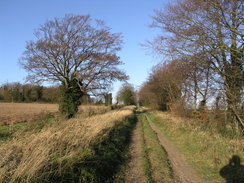
Next came a short stretch of the long track called Roman Road, which, as its name suggests, was one of the roman roads leading to Cambridge. It is a track that I have walked along on many different occasions, and is always an enjoyable stroll. Today, however, I diverted off it after only a short distance, and took a footpath that headed northwards. This entered a long, linear strip of woodland for a time, and after it emerged there were some pleasant views ahead of me as I descended down towards Fulbourn, with a windmill visible off to my left.
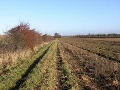
I did not directly enter the village and instead took a series of tracks around the eastern side of the village. One of these was totally blocked by what was obviously a recently-fallen tree; there was no way through the mass of vegetation, and so I was forced to make my way through the resultant gap in the hedge and walk along the edge of the field for a while. The tracks were muddy in places, but aside from this the walk was pleasant, and it was a rude awakening when the last track finally dumped me unceremoniously out onto the road to the east of the village.
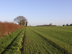
The road took me on towards the railway line, and at the level crossing the remains of the old Fulbourn station could be seen clearly on the right. Immediately beside the line there is a large food factory, and the next footpath squeezed between high chain link fences, a narrow and seemingly unnecessarily restrictive walk. After a short stretch of road I started across another field with a large stream to my left; it was pleasant to do, and although the path soon left the stream it took me on to the Little Wilbraham River, which initially was a narrow and winding rivulet. In the sunshine the walk was superb, with the river flowing peacefully on alongside me as I strolled along, listening to the radio.
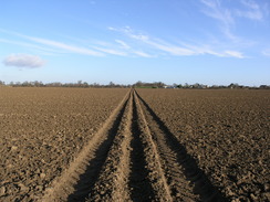
This pleasant stretch ended all too soon when the river reached the A1303 road, and I was forced to follow a cycle path that dived under the busy A14 in a tunnel to reach Quy Mill. This large building is now a hotel, and I have been there many times for conferences and lectures with the previous company I used to work for. It is a nice place, and I found memories filtering back to me as the path bypassed he mill, heading through the car park before heading across a deeply ploughed field. The farmer had kindly attempted to help walkers by flattening the ruts on the footpath, but the muddy conditions still made walking difficult.
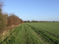
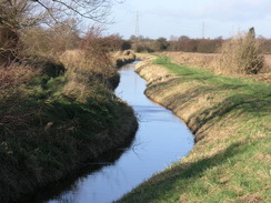
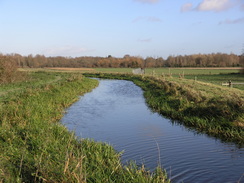
The footpath ended at a road in Stow cum Quy, and almost immediately I turned to follow a track that headed northwards. For quite a distance this track was a broad concrete expanse, and I wondered why it had been built - it certainly does not lead anywhere. This footpath in turn ended at another road, and this led me onto perhaps the most pleasant stretch of today's walk - the stretch following Quy Water (the renamed Little Wilbraham Water that I had followed earlier) towards Lode. Although the path was muddy in places it was a pleasant walk, and the river seemed to be quite full with the water only a couple of feet from the tops of the banks in places, a symptom of the recent heavy rainfall. The river was actually slightly higher than the surrounding land, and the straight course of the river led me to assume that this whole landscape has been drained by man.
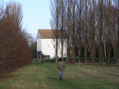
I left the river at Anglesey Abbey, which is famous for its gardens of Snowdrops in the Spring, and took a short-cut to reach the magnificent water mill, still working and bedecked in white clapperboard. A fairly ordinary and muddy stretch followed, as the path followed the Harcamlow Way as it wound around. In places this was hard to follow and the route was unclear on the ground, but aside from going slightly wrong in one place (and having to squeeze through a hedge to get back out in the right place as a consequence) I soon found myself reaching Allicky Farm.
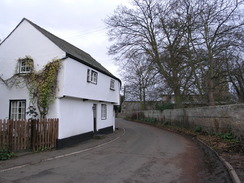
A series of tracks took me on through fields, before eventually bringing me out onto a road to the north of Horningsea. There was no pavement beside the road,so I carefully walked south for a couple of hundred yards to the 30MPH signs and the village. I have always liked this village, and had once looked at renting a thatched cottage on the High Street near the church. Unfortunately, although the price and location had been right for us, the rooms upstairs were so cramped by the roof pitch that I had to crick my neck painfully to get up the stairs. We had not taken it, and instead had rented a larger house in the next village.
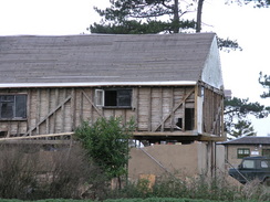
There were two nice pubs in Horningsea, one of which is now a restaurant. As I passed the second of these, the Plough and Fleece, I was tempted to nip in, but time was pressing and dark clouds were starting to gather overhead. Instead I walked on along the pavement beside the road, and when this ended took a footpath on towards the Cam at Baits Bite Lock. By the lock there was a large wattle and daub house that was under restoration, and I was fascinated to see the way it was constructed, with the timber frame and panels all exposed. The ground floor had been nearly decimated, and the upper floors were being held up by a series of props.
Next came a nice walk south towards Fen Ditton, a walk that I had done on many occasions when I had lived in Waterbeach and worked at Acorn on Newmarket Road in Cambridge. The path passed under the A14, with the hut that marked the end of the May Bumps rowing races visible on the other side of the river. Once under the bridge the path rose up to meet a road in Green End, and this led me on towards Fen Ditton Church. It was an area that I knew very well, and it was an enjoyable stroll
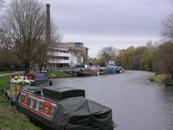
From the church onwards I was really on home ground, and I took a cycle path that headed down to the main part of Fen Ditton. The walk was not particularly pleasant, but when it met another cycle path and started heading across the floodplain it improved massively. This cycle path opened when I lived in Fen Ditton, and it made the walk or cycle ride into town much faster, better and safer. To get under a rail bridge the path is built over the water, and this wooden bridge has weathered much over the last five years. After this came a pleasant riverside walk along a common that led onto the Riverside, a long and quiet road that passed new flats built on the site of the old gasworks, before passing the tall chimney of the Museum of Technology, where a steam engine is still occasionally run.
It was starting to get dark as I passed a stream of boathouses on the other side of the river, and there were still some rowers making their way to and fro as I passed. Before I knew it I was at Magdalene Bridge, where I turned to walk into the centre of the city. I stopped off at Sainsburys to get myself a bottle of Ribena, before reaching the bus station a few minutes before a bus was due. The bus ride home took me an hour, far longer than usual due to the traffic, but I whiled away the time thinking of what had been an enjoyable stroll in the local area.
 |
 |
|
 |
 |
|
Directions
This walks starts off at my flat in Great Shelford; it can equally be started at the railway station, which is reached after ten minutes. Leave the car parking area and walk along the road as it winds through the estate for about fifty yards until it ends at a T-junction with Granham's Road. Turn right along the road and head towards the railway line; cross the level crossing and once on the other side turn immediately to the right, to follow a footpath southwards along the railway line. When the footpath ends at a road continue straight on along the road; when it forks take the right-hand fork that initially skirts the railway line before curving away to the left.
The road ends at a T-junction; turn right and head southwestwards for ten yards towards the level crossing and adjacent railway station before turning left down another road. This heads southeastwards, heading from Great Shelford into Stapleford. Pass Stapleford church on the left, and as a road comes on from the left follow the road as it curves around to the right. Just before the end of the road junction a footpath leads off to the left, heading southeastwards before passing a school and ending at another road. Turn right and join this road for a few yards, before turning to the left to take a footpath that heads across allotments before ending at another road.
Turn right along this road and follow it as it heads south for about fifty yards; when the road curves sharply to the right at Bury Farm turn left to join a footpath that heads through the farm along a track. The track exits the farm, and continues on eastwards through fields. After a kilometre the track passes a large black barn, and after this the track becomes narrower and rougher, eventually becoming a footpath with a hedge on the right before it reaches a hedge. The path squeezes through the hedge and turns to the right, to reach a bridge over the River Granta.
Cross the bridge and continue on southeastwards along a muddy track; when some conifers are reached on the right turn left to join a footpath that heads through an area of young woodland for about fifty yards until a crossroads with another footpath is reached. Here turn left to continue on through the woodland before reaching a footbridge over the River Granta. Cross this bridge and then continue straight on with a hedge to the left. The footpath kinks to the right for a few yards before kinking to the left once again with a hedge once more on the left, before reaching the A1307 road.
At the road turn right and walk along the verge towards some buildings, before carefully crossing the road and heading along a footpath that head between farm buildings. The concrete track soon ends at a gate; go through this and a green lane continues on northeastwards, slowly climbing uphill towards the Roman Road near Copley Hill. Once the wide track of the Roman Road is reached turn right and head downhill along the track; after a few hundred yards another footpath leads off to the left through a hedge. This footpath is not signposted and is not easy to find; however the gap in the hedge is large and just on the other side there is a small bench with some footpath markers on it.
Follow this footpath as it heads slightly east of northwards, heading into a dip before climbing out and reaching a linear patch of woodland. The path heads through the centre of this woodland, and once it ends after about half a mile the path continues on downhill with a hedge on the left. Once the gradient slackens the path joins a little stream on the left, and this is followed until the footpath ends at a road. Turn left along this road and cross the stream via the road bridge; immediately on the other side turn right to start following a track northeastwards for a couple of hundred yards.
When this track reaches a T-junction turn left and follow another track northwestwards for about fifty yards; here the path joins the Harcamlow Way, which it will be following for the next few miles until Horningsea. When a house is reached on the left turn right along a footpath that follows a track northwards, with some woodland on the right. When this track curves to the right, turn left along another footpath that squeezes through trees before becoming a broad track, heading westwards before ending at a road in Fulbourn.
At the road turn right and head northwards towards the level crossing over the railway line. Immediately on the other side of the level crossing there is a large factory building; pass this and then turn right to follow a footpath that squeezes between chain link fences past the factory, before heading out to cross a field to end at a road. Turn right and follow the road eastwards for a few yards; after it crosses a stream a footpath leads off to the left, initially keeping the stream to the left as it heads northwards.
When the stream curves to the left after a few hundred yards continue straight on along the footpath, which heads northwards across a couple of fields before ending in a corner of a field. Here turn left, and follow the southern bank of the Little Wilbraham River slightly north of westwards for a couple of kilometres until it ends at the A1303 road.
Once at the road turn right to cross the road bridge, and once on the other side turn left to take a cycle path that heads down to a tunnel under the A14. On the other side of the tunnel there is a T-junction; turn left and follow a surfaced track for a hundred yards towards Quy Mill. Do not enter the hotel complex at the mill, but instead turn half-right towards the car park, and once in the car park turn right to follow a footpath by a hedge that leads out into an open field. The path heads northeastwards towards Stow Cum Quy; when the fields end it turns to the right to end at Orchard Street. Turn left along this quiet road and follow it for a few yards until it ends at a junction with the B1102 in the village.
At the junction a footpath leads off to the left, heading northwards along a broad concrete track. When the track ends the footpath turns to the right, following the edge of a field before going through a clapper gate to end at Station Road. Turn left and follow this road northwestwards for a few yards to Stone Bridge over Quy Water, with a pond on the left. Cross the bridge, and on the other side turn right to follow a footpath that runs along the western bank of the river. Continue on along the river for a couple of kilometres; eventually an ivy-clad bridge is reached on the right and, shortly afterwards, a large white mill building.
Do not follow the footpath onto the road at the mill but turn left, to join another footpath that heads westwards, soon entering a small patch of woodland. Continue on through the woods, and on the other side when an old railway line is reached turn right and then left to join another footpath. This soon reaches a track; turn left and follow this track southwestwards and then westwards; at a large complex junction turn left to head south with a hedge on the left. This exits a field and becomes a track that soon ends at a T-junction with another track. Turn right and follow this track westwards to Allicky Farm.
At the farm follow the track as it curves to the right, passing the farm buildings on the left before reaching a footpath junction near some power cables. Walk on northwards with a hedge on the right, passing under two sets of power cables before a track is reached. Turn left and follow this track westwards for about a kilometre until it ends at the Horningsea to Waterbeach road. Turn left and carefully follow the road southwards into Horningsea; walk through the village and then leave it southwards along the main road.
A few hundred yards south of the village the pavement ends, and a footpath heads off to the right with a hedge on the right. Follow this footpath as it heads westwards for about a third of a mile until it ends by the River Cam at Baits Bite Lock. Here there are two choices; you can cross the bridge at the locks to follow the western bank of the river southwards, or turn left before the lock is reached to follow the eastern bank, which is the route that I will describe.
The footpath enters a small patch of woodland, before rejoining the riverbank as it heads to a large concrete bridge that carries the A14 over the Cam. On the other side of the bridge the path climbs up a slight slope as it angles away from the river across a field, it then skirts a little cottage before ending at a road at Green End. Join this road and follow it as it winds southwards, heading through Fen Ditton until the war memorial is reached at a road junction, with the church on the right.
At the war memorial turn right for a couple of yards before turning left to join a cycle path that heads southwards. When this reaches a road, turn right along another cycle path, which skirts some buildings on the left. At a junction with another path on the left, turn right and start following the cycle path as it heads across the floodplain towards a green and white bridge over the river. When it reaches the river it turns to the left, and passes under the bridge by means of a wooden path cantilevered out over the water.
Continue on along the cycle path as it follows the river towards the centre of Cambridge, crossing Stourbridge Common before the path ends at a road called Riverside. Join the road and follow it, keeping the river to the right, as it heads past the Museum of Technology, before reaching the large concrete Elizabeth Way road bridge. On the other side of the bridge the path continues as it follows the river along Midsummer Common, passing two footbridges before coming to the elegant Victoria Bridge. Continue along the path as it passes the outdoor swimming pool and Jesus Lock, until it ends by a restaurant.
Here a path dives off to the right around the outside of the building, following a wooden walkway over the river. This ends at a little plaza; continue straight on to Magdelene Bridge. At the bridge turn left and leave the river, to head southeastwards along Magdelene Street towards the centre of the city. Continue straight on along the road as it becomes Sidney Street, and the bus station is a short distance further on on the left, just after the Lion Yard shopping centre on the right.
 |
 |
|
Distances
| From | To | Distance (m) | Ascent (ft) | Descent (ft) |
|---|---|---|---|---|
| Great Shelford | Fulbourn | 7.6 | 190 | 197 |
| Fulbourn | Anglesey Abbey | 6.1 | 59 | 92 |
| Anglesey Abbey | Horningsea | 3.4 | 13 | 16 |
| Horningsea | Cambridge bus station | 5.4 | 75 | 56 |
This makes a total distance of 22.5 miles, with 337 feet of ascent and 361 feet of descent.
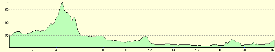
For more information on profiles, ascents and descents, see this page
Transport
There are regular bus services (the C7 bus route) from Cambridge bus station towards Great Shelford, runnign every ten minutes during daytime Monday to Saturday. There are also hourly train services running from Cambridge railway station to Shelford station. Many of the surrouding villages that I walked through also have good bus links into the city centre.
Disclaimer
Please note that I take no responsibility for anything that may happen when following these directions. If you intend to follow this route, then please use the relevant maps and check the route out before you go out. As always when walking, use common sense and you should be fine.
If you find any information on any of these routes that is inaccurate, or you wish to add anything, then please email me.
All images on this site are © of the author. Any reproduction, retransmissions, or republication of all or part of any document found on this site is expressly prohibited, unless the author has explicitly granted its prior written consent to so reproduce, retransmit, or republish the material. All other rights reserved.
Although this site includes links providing convenient direct access to other Internet sites, I do not endorse, approve, certify or make warranties or representations as to the accuracy of the information on these sites.
And finally, enjoy your walking!
Nearby walks
| # | Title | Walk length (miles) |
|---|---|---|
| 2 | Waterbeach to Newmarket Road, Cambridge | 5.4 |
| 5 | A short walk around Waterbeach to Car Dyke | 3.0 |
| 6 | Waterbeach to Newmarket Road, Cambridge | 5.4 |
|
|

|