Walk #753: A circular walk from Thetford
 |
 |
|
General Data
| Date Walked | 16/12/2006 |
| County | Norfolk, Suffolk |
| Start Location | Thetford Station |
| End Location | Thetford Station |
| Start time | 08.31 |
| End time | 15.39 |
| Distance | 20.6 miles |
| Description | This was a long walk around Thetford, mostly along roads but also following short stretches of the Peddars Way and the St Edmunds Way. |
| Pack | Today I carried my 30-litre Karrimor rucksack filled with my waterproofs, two litres of water, and various other odds and ends. |
| Condition | I feel relatively okay after this walk, although I did have a little trouble with my left knee at times. The toes on my left foot hurt for a while, but this soon eased as the walk progressed. |
| Weather | The day started off cloudy with a dull and grey sky overhead, but by mid-morning the clouds had lifted, leaving a bright, sunny buy slightly chilly day. |
| OS map | Landranger number 144 (Thetford & Diss, Breckland & Wymondham) |
 |
 |
|
 |
 |
|
Map of the walk
Maps courtesy of Google Maps. Route for indicative purposes only, and may have been plotted after the walk. Please let me have comments on what you think of this new format. For a detailed table of timings for this walk, please see the table file.
 |
 |
|
Notes
This was a walk that I had been planning to do for some time, as it is relatively local to me and involves walking the northeastern-most part of the Icknield Way long-distance path. I had printed off the route from Anquet about six months ago, so this morning I simply put my stuff together and headed away for the A11.
It did not take me too long to get to Thetford, and I soon parked up outside the station, where I have started or ended several other walks in the past. I paid the money to park the car, and as I started to assemble my gear into my rucksack I chatted to a local man who was waiting to pick someone up from a train. Soon I was ready to head off, and I walked down the road leading from the station, before turning off along another road that headed out towards the A11.
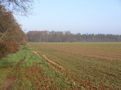
This turned out to be a fairly boring walk, and aside from a short stretch of path through trees beside the road near some housing developments there was little to really see of any note. It was therefore a relief when ever-increasing amount of litter marked the approach to a Tesco superstore perched on he outskirts of the town. This marked the place where I left the main road and started walking eastwards along a minor country road, although for the first couple of hundred yards the road was full of cars going to and from the store.
Next on the right was a garden centre, and as I walked along I started to get a sense of deja vu, as if I had walked along this stretch of road before. When I reached the small hamlet of Kilverstone this was confirmed, as I knew that I had seen the gateway and adjacent gatehouses that lead down to Kilverstone Hall before. It was tempting to go down and see the church, but instead I settled with looking at the fairly unique war memorial, which is an elegant set of seats around a brick structure, totally out of scale for the location.
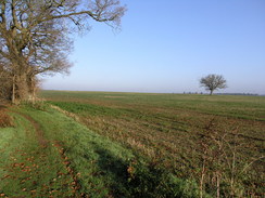
As I walked eastwards along the quiet road I tried to think of when I had last walked along here; it was only when I unfolded the Ordnance Survey map that I realised that I had done it when walking northeastwards from Thetford to Attleborough over four years earlier. The road was quiet and I did not mind the fact that I had walked along it before, and my mind wandered as I listened to Radio Five on my Walkman. At Langmere Boxes there were some pleasant stables on the left, but aside from that there was not much of note as I passed through the small hamlet of Brettenham and headed onwards towards the Peddars Way. On the way I was passed by a tractor pulling a trailer of bright orange, freshly dug carrots, and later on a lorry reversing into a field to pick up some timber.
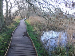
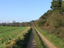
The long road walk was slightly wearisome, and so it was a relief when I finally reached the junction with the Peddars Way, which I had walked along three years before as it headed towards the coast. It was a marked change to be on footpath instead of tarmac, and the underside of my feet sighed relief on the different surface. A section of springy boardwalk was soon reached, and this led on to a bridge over the River Thet. The boardwalk continued on the other side of the bridge, skirting the riverside for a short distance as the low cloud finally burnt off and the sun was unobstructed for the first time in the day.
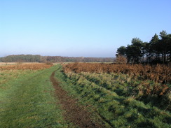
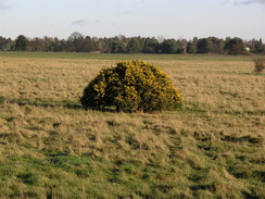
Once the boardwalk ended the way skirted trees as it headed southwards, a pleasant walk amongst the trees that was very varied when compared to the long road plod. After the path crossed a minor road it headed a few yards to a main road, along what was surprisingly a surfaced path. After the main road the path skirted a pleasant band of trees, and with the sun shining down I really enjoyed the stroll. The area became even better as it headed south across heathland, with occasional trees interspersed between the heather, and the footbridge over the infant River Little Ouse was soon reached. This marked the last stretch of the Peddars Way, which again ran across some pleasant heathland before it finally reached another minor road running through the trees.
On the other side of the road was a car park that is the official start of the Peddars Way, and after passing through this I joined the Icknield Way, which joins end-on with the Peddars Way. Although not an National Trail itself the Icknield Way makes a useful link between the Ridgeway and the Peddars Way, allowing a walk along a mainly prehistoric route all the way from Avebury in Wiltshire to the North Sea. Initially the path ran across the heathland with some ponies in a field to the left, before trees started on the left as it slowly curved around to end at another road.
There was a large, muddy puddle at the entrance of the next track, and I skirted around this before taking another good track that headed westwards. The sun was shining brightly and I found myself really enjoying the day, and before I knew it I had reached a trig pillar at the side of the track. I stopped to examine this and take some photographs of it before heading on to reach a junction. On the map the Icknield Way was shown as heading of in two separate directions, and as the waypost pointed down towards the road I followed this branch, which gave some slight but pleasant nonetheless views to the north as the track descended down to the road.
The road led me on westwards, and at the place marked on the map turned off to the left to follow what I supposed was the path through a band of trees. There was no sign on the roadside pointing up through the trees, but as the Icknield Way is not well marked in many places I did not mind this. There was a path through the trees that was easy to follow, and on wither side there were some strange depressions in the ground, square with rounded corners. I have little idea what these are, and it is mysteries such as this that really get to me when I walk.
The trees and the path ended at a bend in a track, and I followed this downhill; about halfway along I saw a Icknield Way marker pointing down to the right back down to the road. This is not where the path is marked on the map, but would also explain why there was no waymarking from the road when I headed off it. When I got back home my GPS log showed me that I had been on the correct route when walking through the trees, so I have no idea whether the path has been diverted.
At Euston the track ended at a main road by a war memorial and a gateway leading down to Euston Hall. Shortly after this I crossed the Black Bourn river on a bridge, but views down it were unfortunately limited due to the overhanging trees. The main road was very busy and it was a relief when I started to follow a minor road that led towards Barnham, but this also proved to be fairly busy with a series of four by fours heading down the road. The reason for this soon became obvious when a tractor pulling a trailer filled with shot game birds came past; obviously a shoot had just ended somewhere on the farmland to the south.
I found the walk along the road to be long and boring, and this was only enlivened when I reached the village of Barnham itself, where I passed the attractive church and then reached the war memorial before eventually hitting another main road. Once across this another long road walk ensued, initially passing a set of offices on the left; I could see no trace of an old railway line marked on the map that is shown as crossing the road. After this ominous warning signs and high fences started appearing on the right-hand side of the road, protecting the Barnham Army camp on Thetford Heath. The area visible on the other side of the fence appeared to be very pleasant moorland, and it looks as though the army's presence allows the land to be far wilder than if they were not here.
Eventually the fence on the right ended and was replaced with open heathland, less scrubby and with fewer of the low trees that had dominated the army camp. As I walked I could see two motocross bikes cross the road in front of me, heading up St Edmund's Way beside the heathland. I soon reached this point, and started following the way northwards as it climbed a slight hill, with the open heath on the right and some woods on the left. Near the top of the rise there was a burnt-out car that was slowly rusting away, and after this the land on the left became more open before a junction with another track was reached.
This track took me eastwards through trees, soon joining another tall fence on the right, this being the northern boundary of the Barnham Camp. It was a fairly dark and secluded stretch, and the noise of distant motorbikes intermittently broke the silence. The trees on the left eventually ended for a short period, before another patch of woodland started. On the map the footpath headed off to the left, and I followed an obvious track just inside the edge of the trees until some power lines were reached.
At around this point the path headed off across some beautiful open heathland, and I turned right too early by the power lines, the scrubby land forcing me to head in a more southeasterly direction instead of the required northeasterly one. This meant that I met the A134 road earlier than I should have done, and I had to carefully follow the road as it crossed Barnhamcross Common. As soon as possible I turned off the road to the right, and started following a series of footpaths across the common, which was fairly scrubby in places.
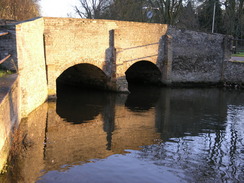
The path took me out onto a road in Thetford, and I joined this to follow it slightly downhill towards Nuns Bridge over the River Thet. This was an attractive but narrow stone bridge over the river, and due to the traffic queuing to cross the single carriageway I headed for a short distance through a car park to reach a footbridge over the river, called the Gentle Bridge, which was opened by HRH Prince Charles in 1999. The riverside scene was very attractive with swans and ducks splashing around in the river, and I looked at this for a few moments before heading back towards the stone bridge.
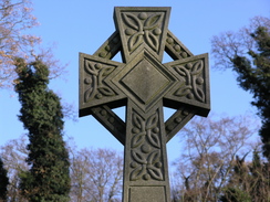
This glowed red in the lowering sun, and I took a couple of snaps of it before heading on along the path beside the river. This passed a pump house, which was built to try and make Thetford a spa town, before heading past some attractive riverside scenes as it entered the centre of the town. Thetford is at a confluence of several rivers, and this made it hard for me to know which river I was walking beside at times. At one point there was a water mill over one of the rivers, and soon after this I came across the strange sight of a statue to a Punjab king, placed in a park in the centre of the town. The statue struck me as being very nice, depicting a man sitting proudly on top of a horse, and it was certainly a worthy addition to the town.
Unfortunately the statue had had some paint thrown over it,and the turban on the head of the seated figure was now blue; I was left wondering why on earth someone would have done this. The figure on the horse is that of Duleep Singh, born in the Punjab in 1838, who was the last Sikh Maharajah of the Punjab. Once the British (in the form of the East India Company) had conquered the province in the Second Anglo-Sikh War the Maharajah went to live at Elveden Hall near the town.
Shortly beyond this there was a triangular bridge over three branches of a river, the meeting point being over the point where they joined. The town was fairly bustling as the sun continued to sink lower in the sky, and I continued on past the pretty town bridge alongside the river. At the next bridge I climbed up the bank to cross the river, and then walked on the short distance to the priory ruins, whose crumbling flint walls were glowing orange in the setting sun. I wandered around the priory studying the walls, remembering well how I had enjoyed my walk around the ruins on a previous visit. The priory was a Cluanic priory founded in 1103, and the floor plan is similar to another Cluanic Priory at Castle Acre, also in Norfolk.
By this time it was nearly dark, and I stopped taking photographs and headed away from the priory, heading along the road before turning up towards the station. In some ways the day's walk had been a slight disappointment as it turned out that I had walked some parts of it before, but generally I felt quite positive - the walk had been enjoyable, and it had certainly been better than sitting at home all day.
Directions
This walks ytarts off at Thetford railway station; leave the station and head southeastwards down Station Road until it ends at a T-junction, and then turn left up Norwich Road. The road heads slightly north of eastwards, passing an ambulance station and police station before reaching a roundabout with the A1066 road. Cross the roundabout and continue northeastwards up Norwich Road until a Teso is reached on the right; pass this Asda and then turn right up a road.
Continue along this road for about three miles as it heads eastwards, passing through Kilverstone and then Langmere before reaching Brettenham. Here ignore the road off to the right and instead head on as the road curves to the left to take a more northeasterly course for about a kilometre. When a signpost for the Peddars Way is reached, turn right and follow this path as it heads southwards. After a few hundred yards it reaches a footbridge over the River Thet; cross this and then continue along the boardwalk on the other side.
The Peddar's Way is easy to follow as it turns to head southwards away from the river, running with some trees on the left before reaching another road a kilometre from the bridge. Cross this road and continue on for a couple of hundred yards on the other side until the A1066 road is reached. Cross this road, and on the other side follow the footpath as it heads southwards through a thin band of trees, with open fields to the left. After a mile a footbridge over the infant River Little Ouse is reached; on the other side of the bridge head south along the path until it ends after a few hundred yards at a minor road opposite a car park.
Cross the road and go through the car park, before starting to follow a new trail, the Icknield Way, southwards. The trail runs with heathland to the left and right before trees start on the right; after a mile the path reaches a road. Cross the road and on the other side join a track that heads on; after a few yards it forks, and take the right-hand fork that becomes a track that heads westwards along the edge of a field. After a kilometre the track passes under some power lines and then reaches a trig pillar, shortly after which there is another fork in the track. Take the right-hand fork that heads westwards for a few yards before curving to the right to head southwestwards, descending downhill along a track until it ends at a road.
Turn left along this road and follow it as it heads southwestwards for about a mile alongside Rushfordroad Belts. When a cottage is visible through the trees on the right turn left, heading southwards along a rough path through a narrow band of trees for a hundred yards until it ends at a bend in a track. At the bend turn right and follow it as it descends downhill to the west for about half a mile before ending at a bend in the A1088 road in Euston. At the A1088 continue straight on along the road; shortly after it crosses a bridge over the Black Bourn river turn right along a minor road.
The road curves to the right, passing Decoy Covert on the left, before settling on a westerly course for a couple of miles towards the village of Barnham. Pass the church in the village and shortly after the war memorial take the right-hand fork in the road, which descends a short distance to reach the A134 road. Cross the road, and continue straight on westwards along another road for a couple of miles past Thetford Heath.
When the road enters an area of trees on both sides, and just before a telephone exchange on the left, turn right to follow the St Edmund Way as it heads northwards along a track, with the trees of Marmansgrave Wood on the left and open heathland on the right. The track summits the small hill and after a kilometre ends at a T-junction with another track by some woodland.
Here turn right and follow a track as it heads eastwards, passing beside a tall fence on the right. The trees on the left end for a small clearing, and when they restart turn left along an obvious track that heads north just inside the trees. Continue on as the track passes under some power lines, before turning right to head northeastwards across Barnhamcross Common to the A134 road. Turn left to head carefully northwards along the road for a short distance,and when you can turn right to join a series of paths that head slightly east of north across the scrubby common land until it reaches Nuns' Bridge Road in Thetford.
Head down this road until Nuns Bridge is reached; this bridge is quite narrow, so if traffic is too busy then there is a footbridge, the Gentle Bridge, a short distance away to the right through the car park. Cross either of the bridges and then turn left, heading past the Nun's Bridge and then head northwestwards along a path called Spring Walk, with the river to the left. The path heads along before reaching a bridge; turn right and cross this to reach Butten Island.
Walk along Butten Island, passing an impressive statue before reaching a three-armed bridge over a junction in the rivers. Cross this bridge, and on the other side turn left towards the Town Bridge and head on along the southern bank of the river towards the next bridge. When this is reached turn left and climb up the bridge to get access to the road, and then turn left to cross the river. Soon on the left is Thetford Priory; if you visit this return to here and then continue on as the road swings to the right. After a short distance turn left up Station Road to reach the railway station, where this walk ends.
Distances
| From | To | Distance (m) | Ascent (ft) | Descent (ft) |
|---|---|---|---|---|
| Thetford station | Start of Peddars Way | 7.7 | 261 | 269 |
| Start of Peddars Way | Barnham Church | 5.9 | 268 | 272 |
| Barnham Church | Thetford station | 7.0 | 242 | 230 |
This makes a total distance of 20.6 miles, with 771 feet of ascent and 771 feet of descent.
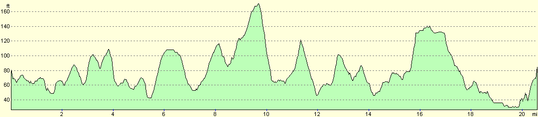
For more information on profiles, ascents and descents, see this page
Disclaimer
Please note that I take no responsibility for anything that may happen when following these directions. If you intend to follow this route, then please use the relevant maps and check the route out before you go out. As always when walking, use common sense and you should be fine.
If you find any information on any of these routes that is inaccurate, or you wish to add anything, then please email me.
All images on this site are © of the author. Any reproduction, retransmissions, or republication of all or part of any document found on this site is expressly prohibited, unless the author has explicitly granted its prior written consent to so reproduce, retransmit, or republish the material. All other rights reserved.
Although this site includes links providing convenient direct access to other Internet sites, I do not endorse, approve, certify or make warranties or representations as to the accuracy of the information on these sites.
And finally, enjoy your walking!
Nearby walks
| # | Title | Walk length (miles) |
|---|---|---|
| 207 | Shippea Hill to Thetford | 20.2 |
| 208 | Thetford to Attleborough | 16.9 |
| 212 | Bury St Edmunds to Thetford | 17.8 |
|
|

|