Walk #983: Ouse Valley Way: a linear walk between Buckingham and Syresham
 |
 |
|
General Data
| Date Walked | 23/02/2018 |
| County | Buckinghamshire, Northamptonshire |
| Start Location | Buckingham |
| End Location | Buckingham |
| Start time | 07.06 |
| End time | 13.15 |
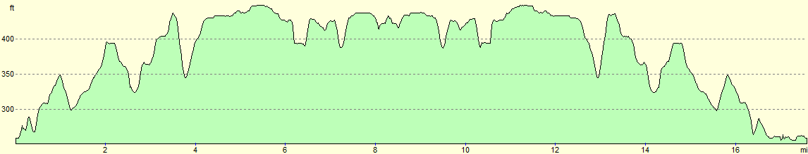
| Distance | 17.5 miles |
| Description | This was a pleasant stroll from Buckingham to the start of the Ouse Valley Way in Syresham, followed by a return by (nearly) the same route back to Buckingham. |
| Pack | Today I carried my 30-litre Karrimor rucksack, filled with water, my waterproofs, a book and other odds and ends. |
| Condition | I feel absolutely fine after this walk. |
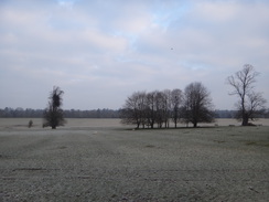
| Weather | The day started off bitterly cold, with a heavy frost and thick ice on any puddles. As the morning wore on the tmperatures rose enough to life the frost and melt the puddles, but a bitter wind meant it was still hat and gloves territory. |
| OS map | Landranger number 152 (Northampton & Milton Keynes) |
 |
 |
|
Map of the walk
Maps courtesy of Google Maps. Route for indicative purposes only, and may have been plotted after the walk. Please let me have comments on what you think of this new format. For a detailed table of timings for this walk, please see the table file.
 |
 |
|
Notes
I only had one walk to do to complete the western end of the Ouse Valley Way, from the town of Buckingham north across the border into Northamptonshire at Syresham. Unfortunately this stretch was only about eight miles long, and there was no convenient public transport between the two places. So I decided to do something that is fairly unusual for me: a linear there-and-back stroll, coming back by the same route that I went out. My drive to Buckingham was uneventful on what was a bitterly cold morning, and I pulled up in the car park behind the Waitrose just after first light.
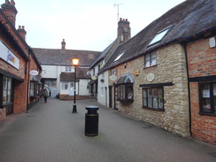
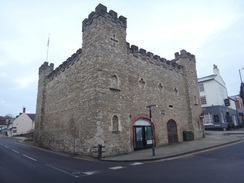
I fettled around for a few minutes before shrugging my rucksack onto my shoulders and heading off into the town. My first task was to find a shop to buy some snacks, and a small Tescos behind the Old Gaol provided both snacks and a friendly Scottish assistant. It was still bitterly cold, and my fingers grew numb as I ate my sandwiches on the short walk out of town. I quickly finished them and pulled on my gloves before starting along Stowe Avenue.
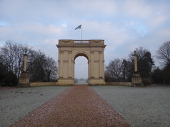
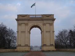
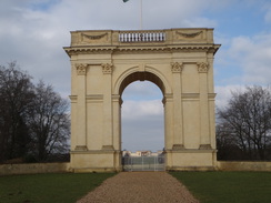
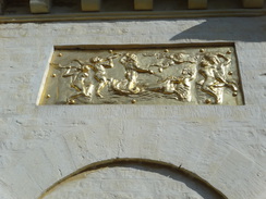
The first few miles of the day were to be dominated by Stowe House. The stately home, now a famous school, is surrounded by elegant landscaped parkland and massive monuments, all suitably grand and imposing. The first sign of these were two small but perfectly-formed lodges either side of the avenue - the Buckingham Lodges, complete with gilded bas-reliefs above the windows. The trail followed a path on the eastern side of the avenue, a few metres away from the road and separated from it by an avenue of trees - presumably to hide the hoi polloi from the users of the road. Each tree had a little lead plaque on it, engraved with what appeared to be a unique number, as if there was some vast ledger somewhere containing the details of each one. The path fell and rose, passing a road leading to the hamlet of Chackmore before the magnificent Corinthian Arch came into view.
It's not often I find such an imposing structure on a country walk, and its sheer scale took my breath away, even though I've seen it before and was expecting it. It dominates its area, and is perfectly aligned with both the avenue and the distant Stowe House, which was just visible through the arch. The house was built over the centuries by the Temple family, who liked adding to their names as much as they did to their house as the generations passed - to the extent that Richard Plantagenet Campbell Temple-Nugent-Brydges-Chandos-Grenville must have found it difficult to live with, as his daughter was called the much more sensible 'Lady Mary Morgan-Grenville'.
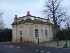
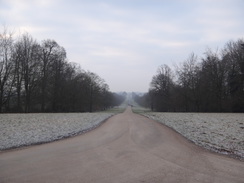
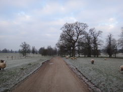
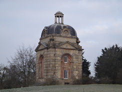
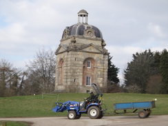
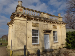
The frost sat heavily on the grass as I took the Queen's Drive, which skirts the main part of the park. Ice on the puddles was so thick that I could put my weight on some without them breaking, but thanks to a dry few days the ground was not too slippery. Now I had warmed up, it started to feel like a perfect winter's morning for a walk. The track passed the end of a lake and headed uphill towards two lodges: the Boycott Pavilions: nothing to do with cricket or Geoffrey, built a few years apart in the early 1700s. Although at first sight similar, they are in detail different; the most obvious one being that the one on the right lacked a cupola.
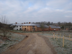
The Queens Drive ended by the pavilions, and a road led on towards Stowe School. This was bus with cars, presumably parents dropping off children, or staff arriving for work. I was surprised to come across a security booth, whose men paid me little attention as I strode past. Soon afterwards I left the road and started heading down a steep track towards Home Farm, which now appears to be the school's equestrian centre. The entire walk so far had been on firm surfaces, and I wondered how long these good conditions would last given the mud I had encountered on the last couple of walks.
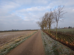
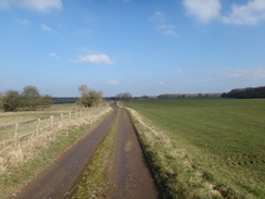
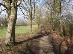
The track rose into Dadford, joining a road before heading along a track past some new houses. Soon I was into countryside, with a good example of the hedge-layers art to my right, with the stems cut to a fraction of their width, with only a sliver of bark remaining, then bent over to lay at an angle. I'm always amazed that the resultant pleachers continue to live and thrive. The top of the hedge had the loose branches woven into it, giving the finished product a very pleasing look. Soon the track turned off towards a farm, and I was left to walk along paths across fields. Navigation proved easy, and the frozen ground meant that my boots remained clean.
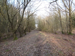
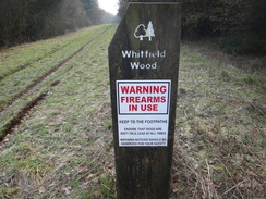
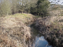
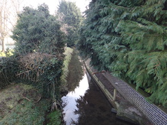
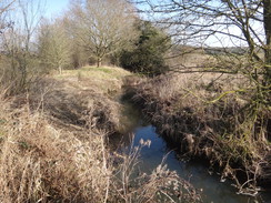
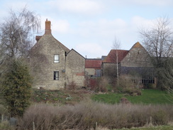
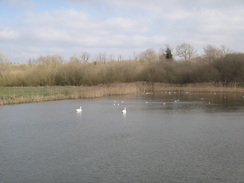
The path entered an area of woodland called Whitfield Wood, where two tall wooden towers stood guard over a cleared track. A sign at the exit to the wood showed the reason for their presence - shooting. Another path led out of the woods and across fields, passing an interesting-looking hodgepodge of buildings down to my right; its name, 'Abbey House', makes me wonder if the farm has an interesting history. The trail joined a road a short distance further on, and a surprise meeting with the Great Ouse at a bridge on the outskirts of Biddlesden Park. This was the first I had seen of the river on today's walk, which feels odd given the trail's name.
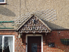
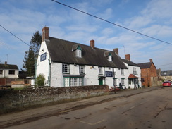
The road was soon left behind, and a track led up past Syresham fieds Farm, followed by a track that once again met the Great Ouse, which at this point was little more than a stream. The track headed uphill to cross the A43 Syresham Bypass on a bridge. A short distance on I went a little wrong, and continued on the track to reach the old main road. From here it was a short distance to walk to the 'official' start of the trail, outside the King's Head pub. There was no obvious marker for the trail, and the pub would not open until the afternoon. Instead, I headed on through the village, and this turned out to be a good decision. Syresham seems a pleasant village, with some attractive buildings and friendly people.
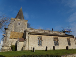
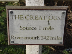
I decided the church would be a good alternative trailhead, and so I headed through the village. Soon I came across the Great Ouse once more, with a sign indicating that it was one mile to the river's source, and 142 miles to its mouth. The church was a short distance away, and some of it was covered with scaffolding as people worked on its roof. I went inside to be greeted by a large and ancient-looking wooden circle - I have no idea what it was there for. The interior turned out to be pleasant, with some of the ten commandments written high up above the chancel arch - apparently a reformation feature. Sadly the building work meant that the interior was not as quiet as it could have been, and soon I headed out for the return walk to Buckingham.
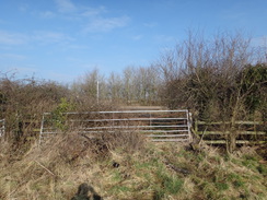
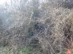
Before that, though, I fancied a few snacks. Some ladies told me where to find the local shop, and I went in and purchased a few rather unhealthy items. Children were in the playground outside the school, their joyful noise and bustle adding some life to what seemed to be an otherwise quiet village. I munched my snacks as I passed the pub and 'started' the return stroll along the trail. I decided to take the official route, rather than the route I had taken earlier, but there were warning signs when I had to clamber over a farm gate from the road as the stile was overgrown. I walked up the edge of the field, only to find a stile and plank bridge were totally overgrown with brambles. It was not just the usual few shoots, but an utterly impenetrable tangle. Fortunately there was a gateway ten metres away, and I went through this to join the track that led to the bridge over the bypass.
The fields that had been frozen a couple of hours before were now muddy, and my boots, which had so far remained clean, soon became dirty. There were more people about now, including three who were walking a local trail from Stowe. At Stowe itself I made a little diversion; the map shows the path from Home Farm heading off the track towards the school. I had not been able to find that short path on my outbound journey, and tried to find it on the return. Electric fences blocked where the path should have led off, and there was no sign of it by the road at the top. Since the path is a couple of hundred metres long at the most, following the track as an alternative is no loss.
The skies were mostly cloudy now, and the breeze exceptionally chilly. When the sun was out and I was sheltered from the wind I was too warm; when the clouds covered the sun and I was exposed to the wind I felt frozen. Thankfully I was soon back at the Corinthian Arch, and I could start the walk back to Buckingham along the avenue. A layer of shredded tree bark had been laid over a muddy patch; this had not been present earlier, and the lovely scent of wood hung in the air.
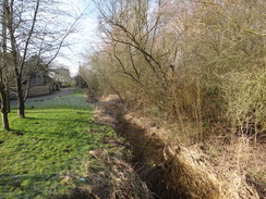
I had plenty of time left once I reached Buckingham, and I decided to use some of the time to walk part of the trail I had got wrong on my last walk. This involved me walking slightly out of the town and following a path that headed down the other side of the rugby club from the one I had taken on Wednesday. This soon rejoined the path I had taken previously, and if anything the other route was preferably and spent a little more time beside the river. A footbridge across the river took me into a park, and another bridge over the river led into the car park.
I have now completed the western section of the Ouse Valley Way, all the way from the trailhead in Syresham in Northamptonshire to Earith in Cambridgeshire. I have fifteen miles to go from Earith to Ely, most of which I have never waked before, and then a little over thirty miles from Ely to the sea, which I have done many times before. Familial obligations mean I won't get to do the Earith to Ely section until well into next month, but I am already planning my next trail.
It seems I've got the walking bug again ..
 |
 |
|
Directions
This walk starts off at the Cornwalls Meadow Car Park in the centre of Buckingham at SP69823400. Leave the car park and either head down the access road, or head past the Waitrose and through the little shopping arcade to reach the High Street in Buckingham. Turn left down the road, passing the Old Gaol Museum on the right, until you reach a mini-roundabout with the White Hart on the left. Turn right up West Street, and follow it as it immediately curves right and then slowly left to head westswards. A fifth of a mile after a roundabout, a junction with Stowe Avenue is reached at SP69243402.
Turn right and follow Stowe Avenue as it heads north-northwestwards; there is a pavement on the right. After a few hundred metres it passes two elegant lodges; here, the path curves right to start running between an avenue of trees, paralleling the road to the left. The path rises and falls gently as it heads arrow-straight; after 1.6 miles it reaches a road leading to Chackamore on the right. Cross the road and continue on along the path; the road curves away to the left. Cross a little footbridge over a ditch, and go through a pedestrian gate, and continue on up through the avenue of trees as the Corinthian Arch becomes visible ahead. Just before it reaches the arch, the path curves to the right for a short distance before ending at a surfaced track in Stowe Park at SP68133628.
Turn left and follow the track past the Corinthian Arch on the right. When the track forks, take the right, hand branch that curves to reach a bridleway gate beside a gate and cattle grid. Go through this and continue following the unsurfaced Queen's Drive; there are a couple of bridleway gates beside cattle grids to be negotiated on this stretch. The track falls down to pass the end of a lake on the right before starting to rise once more, and a mile after the Corinthian Arch it passes another gate / cattle grid combination to end at a complex junction of tracks just in front of the Boycott Pavilions at SP66833697.
Turn right to follow the surfaced road northeastwards, going through any gates you come across. After nearly half a mile a track leads off to the left, curving to the left steeply downhill. The track curves to the right to pass Home Farm on the left, and then a lake on the right, before climbing once more to reach a junction with a road in Dadford. Turn right along the road; there is a pavement on the right, and after about fifty metres, carefully cross the road to head up Bannerlands Gorrell Lane. This passes some houses on the left, and then curves to the right. After half a mile, at SP66073806, the track curves sharply to the right to head towards Gorrell Farm.
Leave the track at the bend and head on across a field, with a hedge on the right. Just before the path curves to the left before the corner of the field, turn right to cross a stile through the hedge, and on the other side turn left to start following the hedge on the left. Pass through a broad gap in a hedge into another field, and at the corner of this field, go through a double-stile and cross a plank footbridge through a hedge into a field. On the other side turn right to follow a hedge on the right. At the corner of this field, go through a stile ahead, and then cross another plank footbridge. On the other side, turn left over another stile into a field. Start following a hedge on the right; when the hedge soon curves right, angle left diagonally across the field, keeping a farm away to the left, to reach a stile in a fence.
Cross the stile and start following a hedge that is away to the left towards an area of woodland ahead. Cross a track leading to the farm, and continue roughly paralleling the hedge, aiming for a stile in a hedge, about fifty metres away from the corner of the field on the left. Cross a plank footbridge over a ditch in front of the stile, and then the stile itself, into another field. Head across this small field towards a gate in a hedge. On the other side cross a plank footbridge and go through a second gate to enter a field. Head across this field to a pedestrian gate beside a field gate, which leads into Whitfield Wood at SP64463918.
Follow the obvious, broad track through the woods; at the far side go through a field gate to enter a field. An obvious track leads down a slight slope towards another field gate. a green track then heads across a field, with Abbey House Farm away to the right. After 250 metres the track joins a concrete track leading from the farm. Turn left along this track and follow it for another 200 metres, and then cross a stile beside a cattle grid to reach a road in Biddlesden. Turn right to head up this road, immediately crossing the Great Ouse on a bridge. After a quarter of a mile the road curves to the left; on the bend turn right to join a track that immediately curves to the left to reach a pedestrian gate beside a field gate.
On the other side, join a track that heads northwards along a field boundary on the left. When this curves left towards Syresham Fields Far after 0.4 miles, continue straight on to a pedestrian gate by a field gate. Head down a narrow field, angling for the far right-hand corner. At the corner, cross a stile in the hedge, go through the hedge, and then cross another stile. Turn half-left across the field for a short distance until it reaches a good track. Turn left to follow this track down to a bridge over the Great Ouse. On the other side, cross a cattle grid and follow the track uphill; it curves to the left and then right to reach a bridge over the Syresham Bypass. On the other side, the track curves to the left and crosses three cattle grids to reach a road opposite a farm (note this last stretch is an easier alternative to the trail). Turn right down this road until it reaches Main Road in Syresham. Carefully cross the road, and on the other side turn right for a short distance to reach a junction with Abbey Road on the left. Turn left along Abbey Road and follow it to reach the King's Head pub on the left at SP63104149, where the Ouse Valley way official starts.
However I wanted to walk to the church, so I continued along Abbey Road, which soon swung to the left to become High Street. Take the first road off to the right, Broad Street, and follow it past houses until it reaches a bridge over the Great Ouse. On the other side the road becomes Wappenham Road; follow it up a slight slope, and when it curves sharply to the left, turn right up Church End. This soon curves left and ascends to reach St James' Church in Syresham at SP63094195.
From here it is simply a case of retracing your steps back to the start. However, here are the written directions.
Leave St James' church and follow Church end downhill; it soon curves to the right to end at a junction with Wappenham Road. Turn left to follow the road downhill to a bridge over the River Ouse. Cross the bridge, and on the other side head on up Broad Street until it ends at a t-junction with High Street obvious the village school. Turn left along High Street for a short distance, and follow it as it curves right to become Abbey Road. The Kings Head pub, the start of the Ouse Valley Way, is on the right at SP63104149.
Leave the pub and follow Abbey Road south for about two hundred metres until it ends at a T-junction with Main Road. Turn left to follow the road east for about fifty metres, then carefully cross the road and go through an overgrown field gate into a field. Follow a hedge on the right, and just before the far corner of the field turn right through a double field gate to gain access to a farm track. Turn left to follow this track as it immediately crosses a bridge over the A43 dual carriageway. On the other side, continue along the track as it curves firstly to the left, and then the right, before heading downhill. It crosses a cattle grid and then the river Great Ouse (which is little more than a stream at this point) on another left-hand bend. Follow the track uphill from the bridge for about fifty metres, and then turn right across the grass for a few metres to reach a stile in a hedge. Go through this and another stile on the other side of the hedge, to enter a narrow field.
Head diagonally uphill along the field. When the top hedge is reached, go through a pedestrian gate beside a field gate, and then follow a rough track as it turns right and then left for a few metres to reach a bend in a track immediately to the east of Syresham Fields Farm. Follow this track as it heads southwards for 0.4 miles, eventually reaching a pedestrian gate beside a field gate that lead onto a bend in a road at SP63504003.
Turn left to follow this road south for a quarter of a mile, descending to cross a small bridge over the Great Ouse. A few metres after the bridge, cross a stile beside a cattle grid to join a concrete track that heads eastwards. When the track curves to the left after 200 metres towards a farm, angle slightly to the right along a rougher track that heads across grass. When a hedge is reached ahead, go through a field gate and continue following the rough track across a field. At the end of the field, go through another field gate to enter Whitfield Wood at SP64133936.
Follow a broad track southeastwards dead-straight through the trees; it emerges through a field gate into a field. Turn slightly right across this field to reach a pedestrian gate, plank footbridge and another gate, all through a single hedge. Angle slightly to the right across the next field, aiming for a stile and plank footbridge that leads into a third field. Parallel a hedge on the right across this field to reach a track that runs across the field. Cross this and head on for a short distance to reach a stile across a fence, and then turn half-right to head diagonally across the field, keeping a farm away to the right.
Join a hedge on the left, and follow this for a few metres to reach the corner of the field. Turn right for a few metres, and then left, to reach a stile. Cross this, and then turn right across a plank footbridge to reach a second stile that leads into a field. Follow a hedge on the left for a couple of hundred metres, and then turn left across a stile in the hedge that leads to a plank footbridge and another stile; the second stile emerges out into a field. Follow a hedge on the right; go through a gap in a hedge ahead, and continue following the hedge on the right. At the corner of this field, cross a stile and go through a gap in the hedge ahead into another field. Keep the hedge on the left for a couple of hundred metres until a bend in a track called Gorrell Lane is reached. Head straight on along this track for nearly half a mile until it ends at a T-junction in Dadford at SP66793798.
Turn right down this road (there is a pavement on the left), and as the road curves right after a short distance, turn left down a track. Follow this as it heads southeastwards, passing a lake on the left and then Home Farm on the right, to reach a track crossing. Continue straight on along the track, which curves gently to the right and meets a higher-quality track in front of Stowe School at SP67243757. Turn right to follow this new track southwestwards with Stowe School away to the left, crossing a couple of cattle grids on the way; when a complex junction of tracks is reached near the Boycott Pavilions after half a mile, take the second track off to the left. Follow this southwards for a short distance to a bridleway gate beside a cattle grid; the track soon gently curves to the left to take a more east-southeasterly course. Go through any gates you come across on the way as the track descends to pass the end of a lake and then climbs up the other side. A mile after the Boycott Pavilions, go through a gate beside a cattle grid and follow the track as it curves sharply to the left to reach another junction in tracks immediately to the south of the Corinthian Arch at SP68083623.
Continue on for a few metres, and just before a track come in from the left, turn right along a path that runs allong a tree avenue, with Stowe Avenue away to the right. After a third of a mile it goes through a pedestrian gate and crosses a plank footbridge to reach a minor road that leads to the hamlet of Chackamore. Cross the road and head on, still with Stowe Avenue on the right, crossing a few minor footbridges on the way. A little over a mile after the road, the path curves to the right to join Stowe Avenue between two beautiful lodge buildings at SP69163419.
Continue along the pavement for another fifth of a mile until Stowe Avenue ends at a T-junction with the A422 road on the western outskirts of Buckingham. Turn left to follow the A422 West Street into the centre of Buckingham; on a right-hand bend before a mini-roundabout, head straight on along Market Hill. This passes Chantry Chapel on the left to reach the Old Gaol at SP69603400.
Cross Moreton Road ahead and continue along the road, passing the town's small bus station. At the entrance to a hospital on the left, turn right to join the High Street. follow the pavement on the left-hand side of the road. Pass Page Hill Avenue and Sandmartin Close, which both come in from the left; about twenty metres after the latter, carefully cross the road to reach the entrance to Lower Wharf. Do not join Lower Wharf, and instead take a grassy footpath following a hedge on the left. When the grass ends, go through a gap in a fence ahead and head on, following a scrappy hedge on the left. When a surfaced track is reached, cross it and pass a children's playground on the right, angling across grass towards a concrete track ahead.
This walk now leaves the Ouse Valley Way. Turn right along the concrete track, passing the children's playground on the right. After a short distance turn left to cross the Great Ouse on a footbridge. The path curves slightly right and then left to follow a hedge on the right. At a T-junction in front of houses, turn right along another path, and shortly afterwards turn left along a narrower path that heads down to reach a footbridge over the river. Cross this to reach the Cornwalls Meadow car park.
 |
 |
|
Distances
| From | To | Distance (m) | Ascent (ft) | Descent (ft) |
|---|---|---|---|---|
| Buckingham | King's Head Pub, Syresham | 7.8 | 525 | 341 |
| King's Head Pub, Syresham | King's Head Pub, Syresham | 1.0 | 16 | 16 |
| King's Head Pub, Syresham | Buckingham | 7.8 | 328 | 492 |
| Buckingham | Buckingham | 0.9 | 26 | 46 |
This makes a total distance of 17.5 miles, with 895 feet of ascent and 895 feet of descent.
For more information on profiles, ascents and descents, see this page
 |
 |
|
 |
 |
|
 |
 |
|
 |
 |
|
 |
 |
|
 |
 |
|
 |
 |
|
 |
 |
|
 |
 |
|
 |
 |
|
 |
 |
|
 |
 |
|
 |
 |
|
Disclaimer
Please note that I take no responsibility for anything that may happen when following these directions. If you intend to follow this route, then please use the relevant maps and check the route out before you go out. As always when walking, use common sense and you should be fine.
If you find any information on any of these routes that is inaccurate, or you wish to add anything, then please email me.
All images on this site are © of the author. Any reproduction, retransmissions, or republication of all or part of any document found on this site is expressly prohibited, unless the author has explicitly granted its prior written consent to so reproduce, retransmit, or republish the material. All other rights reserved.
Although this site includes links providing convenient direct access to other Internet sites, I do not endorse, approve, certify or make warranties or representations as to the accuracy of the information on these sites.
And finally, enjoy your walking!
Nearby walks
| # | Title | Walk length (miles) |
|---|---|---|
| 216 | Northampton to Silverstone via Towcester | 14.5 |
| 612 | A circular walk from Buckingham to Silverstone | 18.8 |
|
|

|