Walk #216: Northampton to Silverstone via Towcester
 |
 |
|
General Data
| Date Walked | 27/08/2002 |
| County | Northamptonshire |
| Start Location | Greyfriars Bus Station, Northampton |
| End Location | Silverstone Church |
| Start time | 10.28 |
| End time | 16.08 |
| Distance | 14.5 miles |
| Description | This was an enjoyable walk combining both canal towpath, footpaths and road walking to go across this nice part of Northamptonshire. |
| Pack | Today I carried my 30-litre Karrimor Hotrock rucksack, which contained a fleece, waterproof coat and trousers. It also contained the usual assortment of odds and ends. It also had two litres of water in it, carried in a 2-litre Platypus container. |
| Condition | I feel fine after this walk, despite having worn my new Scarpa boots once more. I have no problems with my feet, legs or back, and I could easily have walked further if necessary. |
| Weather | The day started off overcast, with a layer of cloud, which despite being thick did not really threaten rain. This cloud slowly broke up until there was some fairly strong sunshine during the middle of the day. Later on the clouds reformed and the wind picked up, although again there was no sign of any rain. |
| OS map | Landranger number 152 (Northampton & Milton Keynes) |
 |
 |
|
 |
 |
|
Map of the walk
Maps courtesy of Google Maps. Route for indicative purposes only, and may have been plotted after the walk. Please let me have comments on what you think of this new format. For a detailed table of timings for this walk, please see the table file.
Notes
The main aim of this walk was to connect the walks I have already completed to Northampton with the walk along the Grand Union Canal last year. The easiest way of doing this seemed to be to walk along the four and three quarter mile Northampton branch of the canal, but as this was such a short walk I decided to extend it by walking on to Towcester and then on to Silverstone.
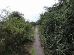
The initial stretch of the canal from Northampton was quite overgrown with rushes, and I doubted that it saw many boats. I was fairly mistaken, however, as the branch was fairly busy which is explained by the fact that the Northampton Branch is a way of getting canal boats to the River Nene and hence all points east. During the initial part of the walk along the canal the view to the right was dominated by the prominent Northampton Lift Tower, which is now disused but is a very prominent local landmark.
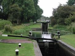
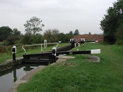
The Rothersthorpe flight of locks was fairly nice, despite the proximity of the M1 and the A45. Beside Lock 10 there are three trees that have horseshoe-shaped benches around them that were formed of wicker baskets filled with earth and with grass growing on top, which gave a very nice effect. Between Locks 6 and 5 is a canal maintenance area on the left, with old lock beams scattered about and piles of new bricks ready for use. Lock 5 had another lift-bridge downstream of it, and the view up the flight from here was very nice. This was the first real view that was available of the entire flight, as the canal turns as it rises and the lower locks are blocked from view by the M1 bridges. Between Lock 3 and 2 a brick bridge passes over the canal. The whole Northampton Arm of the canal has seventeen locks in total, the last one I missed due to it being the lock into the River Nene, which I bypassed. The two wooden lift-bridges on the canal are used by farmers to gain access to fields on the other side of the canal, and it is believed that originally there were far more of these but they have been removed over time. The lock-keepers cottage by Lock 1 was built in 1815 and is the only remaining lock-keepers cottage on the arm, the others having been destroyed. The total drop of the entire Rothersthorpe flight is 77 feet over the thirteen locks, and the entire drop from Gayton Junction to the River Nene is 109 feet. The last feature of the flight of locks is a winding hole by the top lock which the towpath had to sinuously snake around.
I stopped for a while in the porch of St John the Baptist Church in Tiffield so that I could eat my sandwiches and have a little rest, as I was under no time pressure as I had no public transport to catch. The church is quite nice, although I was sad to see that the door was not only locked but had a heavy-duty bar across it. On the walls on either side of the porch were two pretty engraved stones, although the sandstone had weathered and the inscriptions were partly illegible.
By the time I got to Towcester I was feeling thirsty and my two litre Platypus was getting empty, so I stopped off at the Saracens Head Hotel and had a pint of orange and lemonade and a pack of crisps. This hotel is quite nice, and I sat outside in the courtyard, which was quite quiet despite being so near to two roads.
I was lucky enough to get to Silverstone just in time to park my car, get ready and walk down to the bus stop. If I had missed the bus then I would have walked this route in reverse into Northampton; since I reached Silverstone in time then I caught it into Northampton and walked out of the town. This allowed me to have an unhurried walk back to the car and allowed me to have more rest stops than I normally have.
Unfortunately I went wrong on the last section of this walk sometime after passing the disused farmhouse. The path had become very indistinct and I ended up heading too far eastwards and eventually met a little track way that climbed up to meet the A43(T) right on the northern edge of Silverstone. I then had a little walk down the minor Little London Road to get into the centre of the village. This was a classic case where using a compass rather than instinct would have helped massively. Fortunately it did not really extend the walk that much and did not cause many real difficulty.
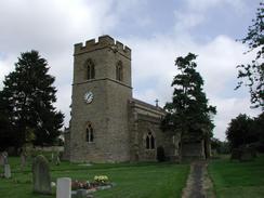
The church in the centre of Silverstone looks as though it is fairly modern, although it is made of stone and fits in quite nicely. The war memorial opposite the church is very nice, and is inscribed in memory of the twenty-five young men who died in the great war. There is another, later, plaque underneath this that commemorates the three people who feel during the Second World War. The centre of the village is quite nice, and it is hard to believe that only a short distance away is the home of British motorsport, the Silverstone racetrack.
Directions
This walk starts off in the Greyfriars Bus Station. Leave the bus station and go into the Grosvenor Shopping Centre before finding the exit into the Market Square. Descend down the Market Square until you pass to the left of the large All Saints Church of St Katherine and St Peter and the war memorial. Just past the church turn right to head past the southern side of the church and the County Hall on the left along George Row. At a T-junction just past the church turn left to head downhill along Bridge Street. Before you get to the bottom of the hill cross over to the right-hand side of the road and continue on down the hill. Cross over the junction with the a dual carriageway with an attractive abandoned church to the left before continuing on down Bridge Street.
Immediately before the bridge over the River Nene is reached turn right down the northern bank of the river, which follows the Nene Way as it squeezes between the river and a Carlsberg Factory. The path jinks to avoid a creek which it crosses by a metal bridge before rejoining the Nene and reaching the A5123 Towcester Road bridge. Follow the path as it rises up to meet the road and then turn left to walk over the bridge to cross to the southern bank of the Grand Union Canal Northampton Branch.
From the bridge turn left to descend down a path to the canal towpath. Once on the towpath turn to head under the bridge and head westwards along the canal. The path soon passes under a low railway bridge. To the left is now a large factory that produces tractors; the retaining wall has some nice bricks that have had pretty patterns engraved into them by local schoolchildren. It then passes under the main-line railway bridge and a little pipe bridge before getting to Lock 16.
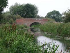
After the lock the canal continues on to pass under a brick-arch bridge (number 14), to the left of which is a recently-lifted railway line (the ballast was fresh with no weeds growing through it, so it has obviously been lifted in the last few years). This line was part of the old London and North Western Northampton to Blisworth line. Pass under another brick-arch bridge that has a pipeline running across the canal beside it. The canal then progresses on to Lock 15, which had a narrow boat coming out of it.
The canal passes under the A45 which is carried overhead on a low concrete viaduct and continues on before turning to the left to head southwards with some new housing on the left before it passes under Banbury Lane on a brick-arch bridge, immediately beyond which is Lock 14. The canal continues on to Lock 11 which has a lift-bridge immediately downstream of it and is followed by a bridge under a slip road of the M1. The canal passes under the M1 on an intriguing concrete arch bridge, at the southern end of which is Lock 13. The canal passes under another slip road and about fifty yards later is Lock 11, which is the start of the main part of the Rothersthorpe flight of locks
Ascend the flight of locks until you get to the old lock-keepers cottage which is beside Lock 1 (otherwise known as Rothersthorpe Top Lock). Follow the towpath around the old winding hole and then turns to the left to pass under the brick-arch bridge no. 3 which has the A43(T) close beside it to the left. It then continues on to pass Sandlanding Wharf and then Gayton Marina on the right. It then passes under bridge No. 2, where the towpath leaves the canal and joins a quiet road to the left. Turn right down this road and pass to the left of the British Waterways Gayton Yard before reaching a bridge that leads over the Grand Union Canal main line, with Gayton Junction immediately to the right.
The road continues on to climb over a bridge over the West Coast Main Line before and ends at a T-junction immediately on the other side of the railway line. At this junction turn right and follow the road as it climbs uphill to the south-southwest before a crossroads is met after about a kilometre. Continue straight on over this crossroads and continue climbing uphill, with a line of trees marking the course of the old Blisworth to Towcester railway line highly visible to the right, which was run by the old Stratford on Avon and Midland Junction railway company. As it nears the top of the hill the road turns sharply to the right and then to the left, to run alongside the cutting of the old railway line for a period.
Continue on along this road as it heads south south westwards to descend downhill into the village of Tiffield. It enters the village along High Street North and continues on through the village past the George pub. When the road turns sharply to the left a road leads off to the right. Turn right down the road and pass over a little bridge over a stream before starting to climb uphill once more. Tiffield church is a little way on along the road before the turn to the left.
Follow the road uphill and under some power lines before slowly descending down to meet the A43(T). Just before the A43(T) an old road leads off to the right, which is marked as a bridleway with the old railway line adjacent to the right. This continues for a few yards before it ends at the A43(T). Carefully cross over the A43(T), where there is a gap in the middle of the dual carriageway which allows you to wait before crossing the second lane. On the other side of the road turn right and climb up the embankment along a tarmac path to an old filled-in railway bridge.
The path continues on along what is obviously the old, abandoned Old Tiffield Road that eventually becomes used again by the time it reaches a Tesco store. At a T-junction turn left to cross a bridge over the River Tove before passing to the left of Towcester Magistrates Court and Police Station. At a crossroads by the Saracens Head Hotel turn right down Bradley Road. Continue on north south westwards down Bradley Road until you get to the Brackley Road Cemetery, which has a chapel in it on the left. When a roundabout is reached after the cemetery continue straight on until you get to the large roundabout with the A43(T). Turn left for a few yards along the pavement until there is a place where the road can be crossed. Carefully cross both carriageways and then cross a field beside a McDonalds until a road leading to the petrol station and McDonalds is reached. Cross over this road and enter a field.
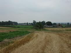
Head straight across this field along the path which is fairly well defined and then cross an old abandoned road into another field. The path heads south-westwards towards a farmhouse. The path passes to the right of the farmhouse before continuing on across fields to the left of another farm before reaching another old farm, which is probably called Park Farm. The path continues on across more fields to reach an abandoned old farm before climbing uphill along a well-defined path. At the top of the hill the path turns to head southwards across four streams for a little over a mile into Silverstone. When the road in Silverstone is met turn right for a short distance and St Michael's Church is on the right
Distances
| From | To | Distance (m) | Ascent (ft) | Descent (ft) |
|---|---|---|---|---|
| Northampton Bus Station | Gayton Junction | 5.9 | 164 | 157 |
| Gayton Junction | Towcester | 5.0 | 299 | 285 |
| Towcester | Silverstone | 3.6 | 203 | 112 |
This makes a total distance of 14.5 miles, with 666 feet of ascent and 554 feet of descent.
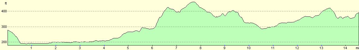
For more information on profiles, ascents and descents, see this page
Transport
I caught the 09.44 X38 bus from Silverstone, which got into Northampton Bus Station at about 10.27, and the ticket cost three pounds for a single. The bus stop in Silverstone is a few yards away from the church, and there are six or seven busses on weekdays, a couple less on Saturdays and only two services on Sunday.
Disclaimer
Please note that I take no responsibility for anything that may happen when following these directions. If you intend to follow this route, then please use the relevant maps and check the route out before you go out. As always when walking, use common sense and you should be fine.
If you find any information on any of these routes that is inaccurate, or you wish to add anything, then please email me.
All images on this site are © of the author. Any reproduction, retransmissions, or republication of all or part of any document found on this site is expressly prohibited, unless the author has explicitly granted its prior written consent to so reproduce, retransmit, or republish the material. All other rights reserved.
Although this site includes links providing convenient direct access to other Internet sites, I do not endorse, approve, certify or make warranties or representations as to the accuracy of the information on these sites.
And finally, enjoy your walking!
Nearby walks
| # | Title | Walk length (miles) |
|---|---|---|
| 137 | Market Harborough to Northampton | 18.3 |
| 157 | Wolverton to Bugbrooke | 16.6 |
| 158 | Bugbrooke to Braunston | 15.1 |
|
|

|