Walk #217:Greenwich to Whyteleafe
 |
 |
|
General Data
| Date Walked | 29/08/2002 |
| County | London, Surrey |
| Start Location | Greenwich (Cutty Sark) |
| End Location | Whyteleafe Station |
| Start time | 09.20 |
| End time | 18.18 |
| Distance | 17.9 miles |
| Description | This was a surprisingly enjoyable walk south out of London. The first half comprised of mainly road walking, but the second half was mostly along secluded green lanes and hills. |
| Pack | Today I carried my 30-litre Karrimor Hotrock rucksack, which contained a fleece, waterproof coat and trousers. It also contained the usual assortment of odds and ends including two books to read on the train journey. It also had two litres of water in it, carried in a 2-litre Platypus container. |
| Condition | I feel absolutely fine after this walk, and have no problems to report. I wore my Saloman cross-trainers with a pair of 1000-mile socks, and have no soreness on my feet or blisters. At the end of the walk I felt more than capable of continuing on further, but time proved to be the limiting factor. |
| Weather | The weather started off quite foggy which blocked the view over London that is normally available from Greenwich Observatory. As the day went on the fog slowly lifted and was replaced with grey cloud. This cloud also broke up slowly, and was replaced with cloud and sunny periods. There was no threat of any rain during the day, and there was not much wind to help keep me cool. |
| OS map | Landranger number 177 (East London, Billericay & Gravesend) and Landranger number 187 (Dorking, Reigate & Crawley area) |
 |
 |
|
 |
 |
|
Map of the walk
Maps courtesy of Google Maps. Route for indicative purposes only, and may have been plotted after the walk. Please let me have comments on what you think of this new format. For a detailed table of timings for this walk, please see the table file.
Notes
This walk was one that I had not meant to do yet, but I took the opportunity of going to see a friend who lives in Purley to do this walk. The walk was quite varied, with a fair amount of road walking but also some very green and secluded sections as well.
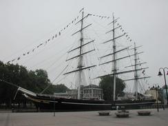
The start of the walk at Greenwich has changed and yet strangely remained the same since I used to live in the area eight years before; the opening of the Docklands Light Railway station at Cutty Sark has caused new developments to spring up and the area look much tidier than I used to remember it; on the other hand the Cutty Sark, Gipsy Moth and the Greenwich Foot Tunnel are the same as I fondly remember them.
I stopped early on for a few minutes at a deli in Greenwich, where I bought myself a cheese and bacon bap which helped keep the hunger pangs away for a little while - the early start from Cambridge meant that I had not had time to have breakfast, so I was in need of something.
Whilst walking down Lewisham High Street I could see a fairly attractive church spire ahead of me on the left. When I reached it I found out that it was a detached spire; the rest of the church obviously having been demolished. A modern building, Sion House, has been built beside it and was attached to it, and the whole assembly proved to be quite an incongruous sight.
I had a stop for twenty-five minutes in The Cricketers pub on Shirley Road, where I had a pint of Courage Bitter and a packet of beef and mustard crisps. I used the opportunity to phone my friend up so that I could check exactly where he lives and to have a quick chat.
I had an extended break when I got to a friend's house in Purley, when I nipped in to have a quick chat. Two hours and a couple of beers later, I left, in a rather happier and slightly more inebriated state. Although the main aim of the walk had been completed, I still felt fit and so I decided to walk on further. I walked down the A22 which was a fairly boring walk (there looks as though there might be a better alternative by walking through Riddlesdown Woods which are on the hillside to the left. I decided to stop at Whyteleafe Station, and this was a good decision as a train came in just a minute after I got to the station.
This walk sets me up well to walk eastwards to get to the county tops of Kent and London on the next walk. After that it should be a couple of day's walking to reach the south coast.
Directions
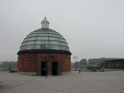
This walk starts off on the plaza by the Cutty Sark in Greenwich, which is on the south bank of the Thames. Leave the plaza and head southwards for a few yards, passing to the right of the Gipsy Moth pub. When the road ends at a T-junction turn left down College Approach until the road turns to the right beside the college gates. Follow the road around the bend as it becomes William Walk and ends at a crossroads with the A206. Cross over the road and continue straight on up William Walk to the gates to Greenwich Park.
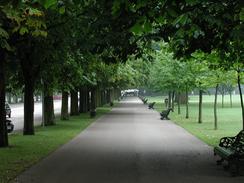
Enter the park through the gates and turn half-left to head up a path towards the Old Royal Observatory. When a circle is met take a path slightly to the right which heads up the eastern side of the hill to meet the observatory, with some lovely views available to the left during the climb. Walk between the observatory to the right and the statue of James Wolfe on the left, and continue past a car park and up the tree-lined Blackheath Avenue through the park to Blackheath Gate.
On the other side of the gate the B210 Charlton Way is met. Turn right down this road for about a hundred yards with the wall of Greenwich Park to your right until you get to the junction with the A2. Continue westwards down the A2 for a few yards until the junction with Whitfield Road is met on the left. Turn left down Whitfield Road for a short distance until it ends at the Hare and Billet Road.
Turn left down the Hare and Billet Road and then turn right down Mounts Pond Road. Continue on and take the third road to the left, Granville Park, which descends downhill and curves around to the right before ending at the A21 Lewisham High Street at the bottom of the hill.
Turn left to head southwards along Lewisham High Street, passing under a railway bridge and with Lewisham Station to the right for a few yards to a large roundabout. At the roundabout continue straight on down Molesworth Street past a shopping centre and car park to the left to another roundabout with a large stone structure in the middle.
Cross over the roundabout and continue on down the A21 Lewisham High Street for about a mile, passing Lewisham Hospital until you reach the junction with Catford Road to the right. Turn right down Catford Road and follow it as it passes the Lewisham Town Hall before climbing over a railway bridge and then immediately under another one, curving to the left as it does so.
Past Catford Railway Station the road becomes known as Catford Hill and follow it as it becomes Perry Hill and passes two blue gasholders before becoming Bell Green. Bell Green ends as the road turns to the right at the junction with the A2218 road to the left. Cross the A2218 and continue straight on southwards along a little lane that becomes Bell Green Lane. This then becomes Kent House Lane and then Kent House Road before it ends at the A234 Beckenham Road, which is just beyond a railway bridge.
Cross over the A234 road and continue straight on down Royston Road. After a short distance the road turns to the left and becomes Westbury Road. Walk down Westbury Road and then take the first left, down Percy Road, which soon becomes Chesham Road and then Ash Grove before it ends at the A214 Elmers End Road.
Turn left and follow the A214 south-eastwards, passing under a railway bridge beside Birkbeck railway station. Continue on down the road towards Elmers End railway station, initially passing to the left of a cemetery, which has a nice stone and metal fence around it. Just before the station is reached a path enters South Norwood Country Park to the right. This is also part of cycle route 21; this can be followed through the park but I chose to make my own way.
I entered the park and took the left-hand path which lead up to meet the northern bank of the lake, where I turned left to follow a track around the eastern end of the lake. The path then continues on south-westwards through the scrubland that is a sort of wild oasis in the city until it reaches a cleared area. Follow the right-hand edge of the cleared area until you reach a path that rises up to cross over the Croydon Tramlink line.
Descend down the other side of the line and follow a track that leads down to a car park. Turn right and exit the car park past Croydon football club down to Albert Road. Turn left along Albert Road until it shortly ends at a T-junction with Estcourt Road. Turn right and go down this road until it ends at another T-junction with Spring Lane. Turn left down Spring Lane, passing under the Croydon Tramlink line beside the Woodside Station, and follow it until it ends at Lower Addiscombe Road beside Ashburton park.
Turn right following the eastern side of the park and then turn left down the A215 Shirley Road. Follow this road south-eastwards past a roundabout with the A232 to the right, where the road becomes a dual carriageway until you reach another roundabout with the A232 Wickham Road to the left. At this roundabout continue straight on down Upper Shirley Road for a short distance until the junction with Oaks Lane is met on the right.
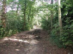
Turn down Oaks Lane and follow it for about a hundred yards until it ends at a gate. Pass through the gate and continue on downhill as the path continues across a golf course until it reaches Oaks Farm. Here the path follows a tarmac driveway until it turns to the left, where the path continues straight on down a mud track. This path meets another tarmac driveway next to Coombe Farm, where it turns to the left and heads down to meet Oaks Road. Turn right down Oaks Road and cross over the Croydon Tramlink line and continue on until it meets the A212 Coombe Lane.
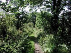
Continue across Coombe Lane and head along Conduit Lane. When the lane turns to the right to enter the Central Nursery continue straight on uphill along a very nice and shaded track. This track continues onwards and then descends steeply downhill to end at Croham Valley Road. Cross this road and head up a lane that leads up towards the Croham Hurst Golf Club. When the club is reached the path passes to the right of a building, with a fence separating the two. The path heads uphill along a scenic wooded track to the top of Croham Hurst, where it turns to the right to descend down some steps that lead down Breakneck Hill until it ends at the B275 Upper Selsdon Road.
Immediately opposite where the path meets the road West Hill Road leads off downhill. Follow this road and take the first road to the right, Essenden Road. About fifty yards down this road a footpath 148 leads off to the left, passing between houses that back onto Beechwood and West Hill Roads. The path starts off being quite wide as it heads uphill between two fences, and you could easily drive a car down it.
The path ends at Sanderstead Road, where you turn right to cross Beechwood Road, which starts to descend downhill. At a pelican crossing change over to the left-hand side of the road and before the bridge under a railway is reached, turn left down St Mary's Road. This road ends at a T-junction at the bottom of the hill, with a garden centre straight ahead.
At the junction turn right and immediately pass under a railway bridge and then turn left down Penwortham Road. When the road ends at a T-junction with Purley Downs Road turn right down that road and then left down Purley Bury Avenue. At the next T-junction turn right down Brancaster Lane and descend downhill to the next T-junction. At this junction turn left to head uphill slong Riddlesdale Road and cross Grasmere Road, which heads off to the right.
At the top of the hill turn right down Warren Road and follow this road downhill. Near the bottom it turns sharply to the left before reaching a complex junction controlled by traffic lights. At the junction do not head straight on which climbs uphill but turn right and then immediately left to continue on down the A22 Godstone Road.
Continue on down the A22, eventually passing the junction with St James's Road on the left before passing to the left of Kenley Station. The road passes to the right of a gasholder and enters Whyteleafe before ending at a roundabout beside the Whyteleafe Tavern. Turn right at this roundabout and the station is on the right - the platform for trains back to Central London is on the far side of the level crossing.
Distances
| From | To | Distance (m) | Ascent (ft) | Descent (ft) |
|---|---|---|---|---|
| Greenwich (Cutty Sark) | Elmers End | 7.2 | 335 | 203 |
| Elmers End | Whyteleafe Station | 10.7 | 1129 | 948 |
This makes a total distance of 17.9 miles, with 1464 feet of ascent and 1151 feet of descent.
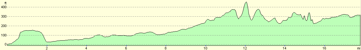
For more information on profiles, ascents and descents, see this page
Transport
There are regular train services running from Whyteleafe Station to London Bridge along the Caterham branch line. Greenwich has a main-line railway station, but the Docklands Light Railway Lewisham branch has a station that comes out a few yards away from Cutty Sark.
Disclaimer
Please note that I take no responsibility for anything that may happen when following these directions. If you intend to follow this route, then please use the relevant maps and check the route out before you go out. As always when walking, use common sense and you should be fine.
If you find any information on any of these routes that is inaccurate, or you wish to add anything, then please email me.
All images on this site are © of the author. Any reproduction, retransmissions, or republication of all or part of any document found on this site is expressly prohibited, unless the author has explicitly granted its prior written consent to so reproduce, retransmit, or republish the material. All other rights reserved.
Although this site includes links providing convenient direct access to other Internet sites, I do not endorse, approve, certify or make warranties or representations as to the accuracy of the information on these sites.
And finally, enjoy your walking!
Nearby walks
| # | Title | Walk length (miles) |
|---|---|---|
| 50 | Paddington to Mile End | 8.3 |
| 51 | Mile End to Enfield Lock | 12.7 |
| 123 | Mile End to Dartford | 15.0 |
|
|

|