Walk #690: Glyndwr's Way: Beacon Hill to Abbeycwmhir
 |
 |
|
General Data
| Date Walked | 01/10/2005 |
| County | Powys |
| Start Location | Beacon Hill |
| End Location | Abbeycwmhir |
| Start time | 07.30 |
| End time | 17.34 |
| Distance | 22.2 miles |
| Description | This long walk followed Glyndwr's Way as it winds around the eastern side of Powys. |
| Pack | Today I carried my 75-litre Craghoppers WildPlaces rucksack, with full camping gear including food, which weighed about 45 pounds. |
| Condition | I am very tired after this walk, and have a slight backache and hotspots on my feet. Aside from these minor issues I am not feeling too bad, particularly when I consider the distance that I have walked today, and the weight that I was carrying. |
| Weather | The heavy rain stopped overnight, leaving a cloudy sky with some sunny patches. These led to a superb sunrise. My hopes that the rain had stopped for good were soon dashed as heavy showers soon arrived. These were blown along by a strong north-westerly wind, which was also unfortunately a headwind for most of the day, with the rain blowing into my face. There were some sunny periods, but these were always followed by further showers. |
| OS map | Landranger number 136 (Newtown, Llanidloes & surrounding area) |
 |
 |
|
 |
 |
|
Map of the walk
Maps courtesy of Google Maps. Route for indicative purposes only, and may have been plotted after the walk. Please let me have comments on what you think of this new format. For a detailed table of timings for this walk, please see the table file.
 |
Notes
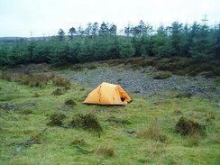
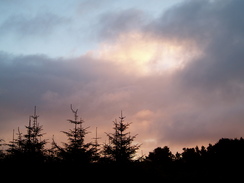
I awoke to the sound of light rain on the tent fabric, and any hopes of a dry day's walking vanished. I quickly dressed and stuck my head out of the tent, to be greeted with a fairly spectacular sunrise, the red sky glowing above the trees. I delayed my departure until it got a little more light, but it was still gloomy outside as I packed up my tent and headed off to rejoin the Way. The going was easy as the Way followed a track past Pool Hill and Stanky Hill, before rising up onto the lee of Black Mountain. The weather was mixed and nowhere near as bad as it had been the previous evening, but nonetheless the short periods of sunshine were interrupted by some showers blown along by the stiff breeze. The hill was an exposed location, and I was relieved that I had made the decision to camp in some shelter last night.
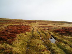
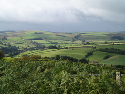
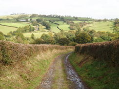
Some of the views were very nice and I highly enjoyed the walk despite the gloomy weather. The Way rose and fell as it followed a series of paths and tracks, eventually descending to a track that was well and truly flooded. I managed to get past this obstruction using some handy half-submerged branches, and strode on. The rest of the route into the small village of Felindre was in enclosed land, and for the first time on the trip I found navigation to be bothersome. Fortunately I did not go wrong and I stayed on the path, but I had to carefully look for signs of the path on the ground, and it was a relief when I reached the B4355 road, which I followed for a short distance into the village.
By this time it was raining fairly heavily, and when I reached the bus stop opposite the post office I decided to stop for a rest, having covered a good distance already. I was disappointed to find no seat in the shelter, but I dropped my pack off anyway and crossed the road to the post office, hoping to be able to fill up a water bottle. Inside I found an elderly lady manning the counter, and as soon as I entered she made me feel very welcome. As soon as she discovered that I had been camping on the moors overnight she offered me a cup of tea, and it was an offer that I gladly accepted. We chatted for about half an hour and it turns out that she is a relative of the owner of the Greyhound pub in Llangunlo that I visited yesterday evening; it is a very close and friendly community. As we chatted various locals came in and took goods without paying, the lady entering the purchases into books for later payment. I loved being in such an obviously friendly area, and her kindness was superb.
Eventually I had to drag myself away, and the lady told me that the New Inn in Llanbadarn Fynydd would be open, and would probably be serving meals. The rain had nearly stopped, so I headed off down the road before suddenly hitting a steep path that climbed up towards Cefn Wood. For the first time on this trip I found the ascent to be hard, a fact that I put down to the way that I had shouldered my rucksack after the stop. After correcting the positioning of the straps I continues on along the hill, before descending down to the little farm at Rhuvid before climbing uphill once more. Suddenly the weather became fairly awful, and as the path skirted fields towards Hope's Castle Farm I found myself to be quite exposed and chilly. It really was not very nice to be walking in such weather, and I was relieved when the rain died, although the stiff breeze remained.
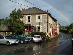
A road took me westwards downhill, and at the bottom the Way turned left to start climbing uphill along a bridleway. This ended up being slightly indistinct on the ground when it entered some trees, but I managed to stay on course as the gradient slackened and it approached the mound of the 13th Century Castell-y-blaidd (the Castle of the Wolf). The bridleway continued onwards to a high and exposed road, which I followed all the way downhill southwestwards towards he A483(T) in Llanbadarn Fynydd . I was glad to discover that the New Inn was open, and I entered it and sat down at table. I ordered a drink and an omelette, before noticing a couple in walking gear sitting at an adjacent table. We started chatting, and I soon discovered that they were walking Glyndwr's Way in sections, doing an eight or nine mile stretch before walking back to the car. This is a fairly unusual way of walking a long-distance trail and is quite time consuming as you walk each section twice; however it does mean that you get the views in both directions and do not have to bother with the worries of accommodation and / or public transport. Eventually they bade their farewells and headed off for their return walk to Felindre, and I had to decided whether to continue on. The New Inn did accommodation and it was tempting to stop for the day, but there was still plenty of daylight and a little under nine miles to Abbey-cwm-hir.
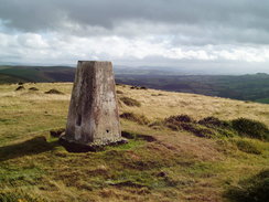
Eventually the clearing of the weather outside persuaded me to continue on, so I shouldered my rucksack and headed off along the road towards the pretty little chapel that is situated by the Afon Ieithon. A short stretch of road led me to a track that headed uphill directly to the west. It was an easy climb and I thoroughly enjoyed it in the improved weather, but eventually the track was left and the Way started heading south along an area of boggy ground before climbing up towards the summit of Moel Dod. The climb was nice, and once at the top the path skirted the hill south towards Yr Allt, where I passed a farmer in a four-wheel drive out feeding some sheep. A very steep descent took me down to the road at Tynypant Farm, and this was followed by an equally steep ascent up a path past Bwlch. By this stage fatigue was starting to set in and I took my time before reaching the summit of Ysged-ffordd, although I did find the energy to visit the trig pillar.
The views from here were very good, although the chilly breeze meant that I did not stay too long. A very steep descent followed through some woodland, and the wet, sodden ground underfoot made this slightly treacherous in one or two places. The gradient slackened by Neuadd-fach, before the path crossed Bachell Brook and climbing a shirt distance to reach a road. I was thankful to see this as it meant that I had an easy walk for a little over a mile, although I was troubled by a steep climb in the road that I had not noticed on the map. When the road reached Dyfaenor the Way left it, and headed along a path westwards. It soon crossed a stream by a little plank bridge in a wooded area, and as I stepped onto this my foot slipped on the wet, slimy wood. My boot slipped forwards, and as it stopped harshly my foot continued onwards, bashing my toes against the toecap. This hurt, but I walked on out of the trees, passing the farm at Brynmoil before joining a track that gave me a thankfully easy walk down to the road in Abbey-cwm-hir.
It was raining again as I reached Home Farm in the tiny village, where I had phoned up to book a camping spot. I was greeted by a friendly farmer, who told me that I could camp by the dramatic ruins of the abbey. I quickly put my tent up in the rain, but I could not resist walking around the ruins before I got in; the dramatic shattered stone walls towering above my tent. Although there was a shower available I decide not to have one, and instead went to pay for the night. I was surprised to find that the cost for the night was a donation to a local air ambulance, and so I gave a donation before going back to my tent. The local pub was due to open at eight, and so when it was time I headed off in the dark, emerging from my tent into a surprisingly chilly night. The pub turned out to be connected to a local house, and I enjoyed a couple of pints before heading down the road once more to the abbey and my tent.
Directions
|
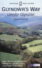
The walk is also covered in detail in the Glyndwr's Way National Trail Guide, by David Perrott, ISBN 1 85410 968 5, published by Aurum Press Ltd. Please click on the link to the right to access the Amazon page for the guidebok. |
|
Distances
| From | To | Distance (m) | Ascent (ft) | Descent (ft) |
|---|---|---|---|---|
| Beacon Hill | Felindre | 6.0 | 561 | 1188 |
| Felindre | Llanbadarn Fynydd | 7.6 | 1230 | 1158 |
| Llanbadarn Fynydd | Abbey-cwm-hir | 8.6 | 1726 | 1834 |
This makes a total distance of 22.2 miles, with 3517 feet of ascent and 4180 feet of descent.
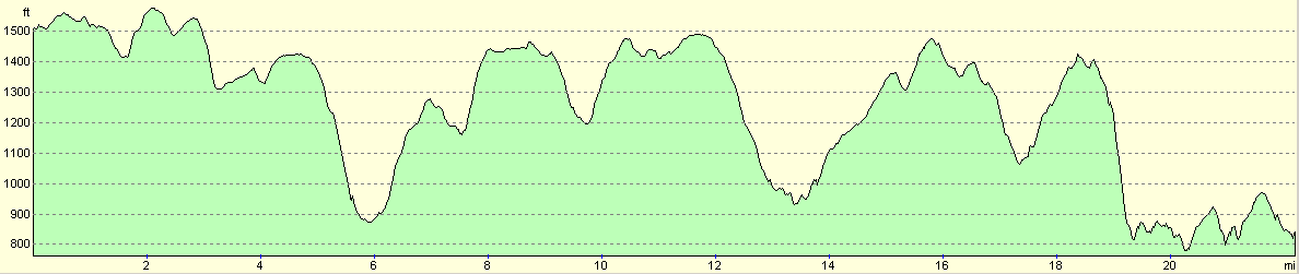
For more information on profiles, ascents and descents, see this page
Accommodation
I spent the night camping at Home Farm in Abbey-cwm-hir; the site was immediately adjacent to (and around) the ruins of the abbey. All it cost to camp was a donation to the local air ambulance. There is a shower and toilet available to use, and being able to camp immediately adjacent to the ruins of the abbey was a superb experience. Home Farm also does accommodation, and can be contacted on (01597) 851666.
Disclaimer
Please note that I take no responsibility for anything that may happen when following these directions. If you intend to follow this route, then please use the relevant maps and check the route out before you go out. As always when walking, use common sense and you should be fine.
If you find any information on any of these routes that is inaccurate, or you wish to add anything, then please email me.
All images on this site are © of the author. Any reproduction, retransmissions, or republication of all or part of any document found on this site is expressly prohibited, unless the author has explicitly granted its prior written consent to so reproduce, retransmit, or republish the material. All other rights reserved.
Although this site includes links providing convenient direct access to other Internet sites, I do not endorse, approve, certify or make warranties or representations as to the accuracy of the information on these sites.
And finally, enjoy your walking!
This walk was mentioned in the following routes:
| Glyndwr's Way |
Nearby walks
| # | Title | Walk length (miles) |
|---|---|---|
| 689 | Glyndwr's Way: Knighton to Beacon Lodge | 10.8 |
| 691 | Glyndwr's Way: Abbeycwmhir to Llanidloes | 16.7 |
| 746 | Welshpool to Newtown | 14.7 |
|
|

|