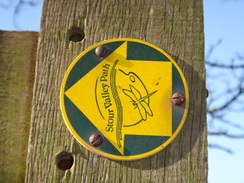
Walk #946:Stour Valley Path: A walk from Newmarket to Little Bradley
 |
 |
|
General Data
| Date Walked | 27/03/2012 |
| County | Suffolk, Cambridgeshire |
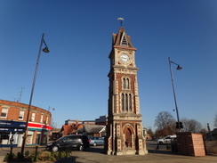
| Start Location | Newmarket clock tower |
| End Location | Newmarket Grosvenor Yard car park |
| Start time | 09.16 |
| End time | 17.25 |
| Distance | 22.1 miles |
| Description | This walk followed the first stage of the Stour Valley Way southeastwards from Newmarket, including a rather pleasant amble along the Devil's Dyke. |
| Pack | Today I carried my 30-litre Karrimor rucksack, filled with water, my waterproofs, a book and other odds and ends. |
| Condition | I am fairly tired, although otherwise feel fine. |
| Weather | Today was dominated by glorious sunshine, and it was spectacularly warm for the time of year; it was more like July than March. |
| OS map | Landranger number 154 (Cambridge & Newmarket, Saffron Walden) |
 |
 |
|
Map of the walk
Maps courtesy of Google Maps. Route for indicative purposes only, and may have been plotted after the walk. Please let me have comments on what you think of this new format. For a detailed table of timings for this walk, please see the table file.
 |
 |
|
Notes
It had been a couple of months since my last walk, but todays forecast of good weather forced me to put my other work to one side. I had walked the Stour Valley Way in Dorset a couple of years ago, and now I wanted to do its Suffolk counterpart. As usual I wanted to walk the river-trail from source to sea, so I drove to Newmarket to start the walk. Sadly I did not manage to set off until late, which meant that I pulled up in the long-stay car park in Newmarket well after nine in the morning. A ticket for the day was remarkably cheap and soon I was striding off towards the start of the trail at the clock tower at the northeastern end of the town.
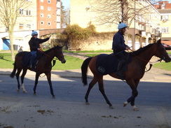
For some reason the trail does not pass the many interesting buildings and shops that line the High Street, and instead takes a looping, indirect route through the town. After nipping into the shopping centre to buy some sandwiches I passed the bus station and saw my first horses of the day. Newmarket is famous for its racecourse, but I was surprised to see steady streams of horses and riders heading right through the centre of the town. They were being taken to and from the stables at Newmarket Racecourse to the exercise tracks to the east of the town.
I was surprised to see a wide pavement through the town specifically to allow horses to trot safely. The trail followed this for quite a distance, although the horses and riders were often out of sight behind a hedge. Despite having been to Newmarket on numerous occasions I had never seen this sight before, perhaps because I had visited at the wrong time of day.
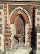
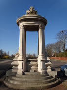
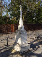
The looping route joined the main road beside a magnificent drinking fountain to the west of town. I stopped to take a few photo of the fountain, whose gleaming white stone deserves a better position. Sadly the next mile and a half followed the main road southwestwards; it was a boring walk, although with some reasonable views over the Heath and towards the grandstand for the Rowley Mile Course. These were not enough compensation for the road walking, and I decided to take a different route back later in the day.
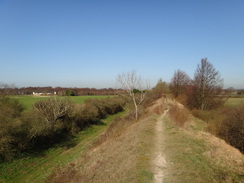
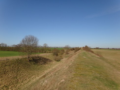
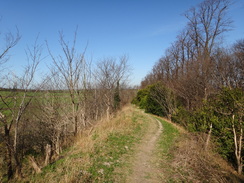
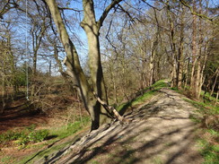
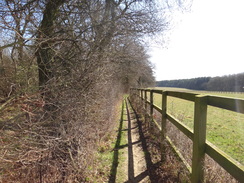
The reason for the road walking soon came into view - the Devils Dyke. This ancient earthwork stretches from the village of Reach near the River Cam to Ditton Green on the hills to the southeast. I have walked this on many occasions and it is a wonderful stroll. Initially the dyke passes a golf course and this stretch is fairly wonderful - the dyke itself is high and the ditch to the right deep, giving some wonderful views. I strolled along, the boring road walk having been forgotten. The road did not give the Stour Valley Path a good start, but it was worth it for this opportunity to walk the dyke.
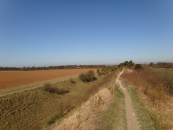
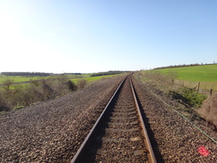
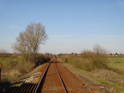
The dyke descends to cross the single-track Cambridge to Newmarket railway line and then a road, before starting to climb uphill. This stretch of the dyke is more overgrown with mature trees growing on the sides of the dyke, giving it a very different feeling to the earlier stretch of dyke. After crossing another road the trail followed the dyke, before heading off to the right in the company of the Icknield Way. This
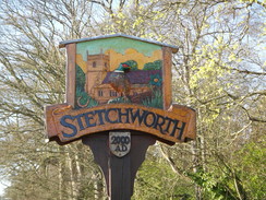
It was growing into a boiling-hot March day, and annoyingly I had left my sun-tan lotion at home. Fortunately I did have my Tilley hat, and I angled it to protect me from the worst of the sun. My feet were also starting to ache, which I took to be a result of the months since my last stroll. The Icknield Way and Stour Valley Path forms a confusing network of trails in this area, a situation made worse by the Icknield Way having both a walking and a riding route. However it proved easy to find the proper route and soon I was strolling into Stetchworth.
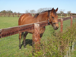
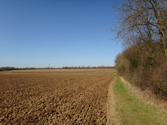
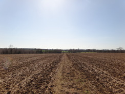
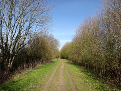
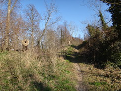
The trail followed a road out of the village, passing a little post office-cum-shop on the way before heading along a path. This ran between fences that guarded paddocks on either side; a friendly horse came to say hello as I passed. After the paddocks were left behind the trail followed a path that skirted the edge of patches of woodland as it headed southeastwards. Hedges and the woodland protected me from the worst of the sun for a couple of miles, although I was well aware that I was slowly running out of water.
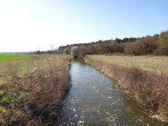
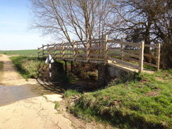
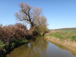
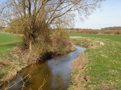
Eventually the trail met a little river that ran through a series of weirs. The number of weirs felt out of place for such a gradual fall and I wondered what their purpose was. This stretch ended when a footbridge beside a ford led across the River Stour to meet the end of a road; the ford gave me an opportunity to splash in the shallow water. From here the path roughly followed the southern bank of the Stour for half a mile before ending at a road beside a bridge. More road walking took me eastwards before a path headed south, diving into a little valley before climbing up the other side to reach the end of a road in Little Bradley.
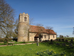
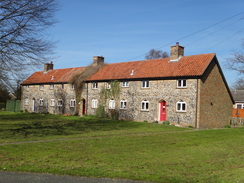
The road took me down to the church in Little Bradley, which was a delightful example of a round-tower church, and then led onwards. Here I was faced with a choice - I could walk another mile south to Little Thurlow, where a pub is marked on the map. That would allow me to fill up my water bottles, but would also extend the walk. As I was unsure if the pub would be open, and I had already walked twelve miles, I decided to head back. Instead of following the Stour Valley Path I decided to take a different route following the road.
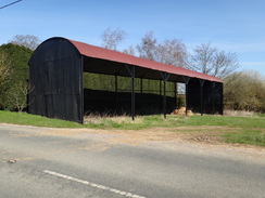
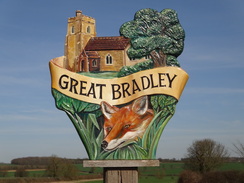
This took me through Great Bradley, after which it took a northwesterly course to reach Burrough Green. I soon came across a pub set in a delightful spot away from the road, but sadly this had shut just seven minutes earlier. Annoyed, I strolled on, eking out the last dregs of my water. My route joined the riders route of the Icknield Way as it headed towards Gipsy Hall. The name made me think of a grand hall; instead it seemed to be little more than a disappointing row of cottages.
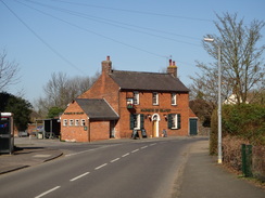
The track took me across a little road at Dullingham Ley before heading between paddocks to rejoin the Stour Valley path; this took me on back into Stetchworth. I was happy to find that the village pub was open, and I went in to have a quick drink and a rest. The staff were friendly and filled up my water bottle as I supped a pint. I also took my boots off to allow me overheating feet to cool down slightly.
My legs and feet hurt once I set off, but the ache soon died off as the road took me northwestwards. The last few miles of the day were along roads, the last part being along the B1061. Fortunately the traffic was not too bad and I was soon striding past the Devils Dyke, which I had followed earlier, and across the Newmarket to Cambridge railway line. I eventually reached my car in Newmarket feeling very tired after an interesting, if not classic, walk. Thankfully the next few stretches of the trail look more promising.
 |
 |
|
Directions
This walk starts at the clock tower at the northeastern end of the High Street in Newmarket, grid reference TL645635. Leave the clock tower and carefully cross the High Street before heading up Exeter Road, with shops on the left. When this ends at a road junction turn left along Fred Archer Way, passing a car park on the left. The pavement leads towards Newmarket bus station and The Guineas shopping centre; do not enter the shops and instead turn right at the end of the bus station to rejoin the pavement beside the road.
Continue along the road; it soon curves to the right. Shortly afterwards take the first road to the left, Rowley Drive. Take care to follow the pavement and not the wide track on the left, which is a walkway for horses from the Newmarket Stables. After 0.6 miles Rowley Drive ends at a T-junction with Hamilton Road. Turn left to follow Hamilton Road southeastwards up a slight slope. After 150 yards turn left along Birdcage Walk; this angles towards the A1304 road, meeting it beside a rather magnificent fountain at TL637629.
Carefully cross the A1304 to reach the pavement on the other side of the road. Turn right to follow the A1304 southwestwards for 1.5 miles; the pavement continues on the left as it passes a golf course on the left and the racecourse on the right. Eventually the Devils Dyke is reached at TL619614. Turn left to clamber up the bank and follow it southeastwards; on the way it goes through a series of gates that guard golf tees that sit on the bank. Nearly a mile after joining the Dyke, the path goes through a gate and descends steps to reach the Newmarket to Cambridge railway line at TL630604.
Carefully cross the railway line and then climb more steps to reach a clapper gate that leads onto to the top of the dyke. After 150 yards some wooden steps lead to a footbridge over a stream and the B1061 road. Turn right down the road for five yards and then left through a gate. Climb onto the Dyke once more; it slowly ascends the hillside for nearly three-quarters of a mile before descending to reach a road at TL641595.
Cross the road and on the other side turn left for about five yards before turning right up some wooden steps to rejoin the top of the Dyke. Continue along the Dyke; it descends some steps to cross a footbridge over a stream that cuts across the Dyke before climbing once more. After half a mile a junction with the Icknield Way is reached at the base of some steps at TL648589.
Here turn right to leave the dyke; the path heads down to meet the edge of a field. Follow the path southwestwards along the edge of a field with a hedge on the right; it crosses a track and continues on. Some cottages start on the right before the path dives between hedges to reach Strollers Way in Stetchworth. Turn right for a couple of yards and then left to take a path that runs between fences; this soon ends at a crossroads in Stetchworth at TL640583, with the Maquis of Granby pub a short distance away to the right.
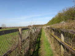
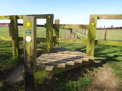
Turn left to follow the road southeastwards for a fifth of a mile; shortly after the pavement ends turn right through a clapper gate beside a field gate to join a path that runs between fences that guard paddocks on either side. The path crosses a track and curves slightly to the left to head slightly downhill, still between paddocks. When the fences end cross a stile at TL642576 to reach a footbridge; on the other side turn left for about five yards and then right through a gap in a hedge. Follow a ditch on the left towards the trees of Marmers Wood ahead.
As it meets the woodland the path curves slightly to the right; at the end of the field it crosses a plank footbridge over a ditch and then curves to the left, keeping the woodland to the left and a hedge on the right. The path continues in a rough southeasterly direction with hedge on the right and a couple of patches of woodland on the left. After a mile the path crosses a footbridge over a stream at TL657563, after which it continues climbing uphill. After another sixth of a mile at TL659561 it crosses a plank footbridge and enters a field. Turn slightly to the right, keeping a hedge to the right.
Continue on as the path slowly descends towards Ten Wood. When the wood is reached turn right across a field bridge across a ditch, then immediately left to keep the woods to the left. The path continues downhill and crosses a field bridge over another ditch and then heads uphill, still with the trees to the left. At the top of the field the path skirts between the wood on the left and a fence on the right; it eventually curves to the left and crosses a plank footbridge at TL666555. On the other side turn right to follow a hedge on the right. At the end of this field the path goes through a hedge and continues on, still with the woodland to the right.
When the woodland on the right suddenly ends, continue along the path as it curves slightly to the right across a field, aiming for a field bridge across a stream next to a weir at TL672551. Cross the bridge and on the other side turn right to start following the stream on the right. The path passes several weirs; at the end of the field it crosses a concrete ford over a stream and heads on along a rough track, still with the stream to the right.
At TL671542 the stream curves to the left; cross a field bridge across it and continue on along the track. After a quarter of a mile it approaches a ford over the River Stour; a footbridge to the left offers a way of keeping your feet dry. Continue along the track on the southern side of the river for a short distance to reach the end of a public road beside some houses at TL66858.
Do not join the road and instead turn left along a footpath that follows a hedge on the left. At the end of this field it passes a band of woodland on the right and curves to the left over a little ditch. It then curves to the right for a short distance, heading roughly towards Great Bradley church. After a short distance the path crosses a ditch and curves to the left for about twenty yards and then right, following the River Stour on the left. The path soon reaches a road beside a bridge over the river at TL675532.
Turn left to cross the bridge over the river and follow the road as it twists and turns in a rough easterly direction, slowly climbing uphill. Just before a house is reached after half a mile at TL682531, turn right down a footpath, following a hedge on the left. At the end of the field cross a ditch and follow the path as it curves slightly to the right to head downhill across a field. This leads to a field bridge over a stream at TL683572. Cross the stream and head straight on across another field, aiming for a gap in a hedge ahead.
Go through the gap in the hedge and follow the path as it curves slightly to the right. It follows a hedge on the right and becomes a track. This meets the end of a surfaced road at TL684523. Turn right down this road; it soon curves to the left to head south towards the round-tower of Little Bradley church. Shortly afterwards the road crosses a stream and curves to the right to head southwestwards. A fifth of a mile after the church, the road crosses the River Stour. On the other side of the bridge the Stour Valley Path leads off to the left.
Here this walk leaves the trail behind. Instead of turning left along the path continue uphill along the road for a quarter of a mile until it ends at a T-junction with the B1061 road at TL675517. Turn right to start following the road as it heads northwestwards. It heads through the village of Great Bradley and continues on; after 3.5 miles on the road the village of Burrough Green is reached on the left at TL638554. There is no pavement on this long stretch of road walking but the traffic is not too heavy. However care needs taking.
Walk through Burrough Green and follow the road as it leaves the village. Shortly after a left-hand bend turn right along a bridleway that follows a track eastwards for 250 yards towards some cottages at Gipsy Hall. Here the track turns to the left to head north, passing the cottages on the right. After 0.4 miles the track ends at a small road at TL641565.
Turn left along this road for a couple of yards before turning right down a path that runs between a fence on the right and a hedge on the left. The path curves to the right in company with the fence and goes round three sides of a paddock before curving to the left away from the paddock. It crosses a footbridge over a ditch at TL642566 and continues on between two fences. It crosses a surfaced lane guarded by gates and heads on, still between fences. At TL644571 the path goes through a gap in a hedge and rejoins the Stour Valley Path beside Marmers Wood.
Turn left to follow the trail in the opposite direction to which it was walked earlier; after a short distance the path curves to the right to cross a footbridge and follows the edge of the woodland and a ditch on the right. When the ditch curves to the left follow it, keeping it on the right. At the end of the field the path goes through a gap in a hedge to meet a track at TL642576.
Turn left down this track for about five yards and then right across a footbridge to reach a stile. On the other side of the stile continue up a slight slope between fences that guard paddocks. The path crosses a track and continues on between fences to reach a clapper gate beside a field gate. Go through the clapper gate to reach a road at TL642581. Here turn left and follow the road northwestwards for a fifth of a mile into the centre of Stetchworth.
Here the Stour Valley Path is once again left behind; if you want you can retrace your steps along the trail, although that adds a number of miles onto the route. The route described here is shorter, but involves more road walking. Continue along the road as it heads north and then northwestwards for a little over a mile until it ends at a T-junction with the B1061 road at TL631597. Turn right and carefully follow the B1061 north-northeastwards; it crosses the course of the Devils Dyke and a railway line. After nearly two miles it curves to the left and climbs uphill for a short distance before ending at a T-junction with the A1304 on the western outskirts of Newmarket.
Carefully cross the main road and turn right to head downhill towards the centre of Newmarket. After a quarter of a mile turn left up a narrow road called Grosvenor Yard to reach the long-stay car park; if you wish to reach the start of this walk at the clock tower then simply continue along the High Street for a third of a mile.
 |
 |
|
Distances
| From | To | Distance (m) | Ascent (ft) | Descent (ft) |
|---|---|---|---|---|
| Newmarket clock tower | Stetchworth | 6.4 | 407 | 161 |
| Stetchworth | Little Bradley | 5.8 | 184 | 269 |
| Little Bradley | Stetchworth | 6.1 | 312 | 226 |
| Stetchworth | Newmarket Grosvenor Yard car park | 3.8 | 59 | 302 |
This makes a total distance of 22.1 miles, with 962 feet of ascent and 658 feet of descent.
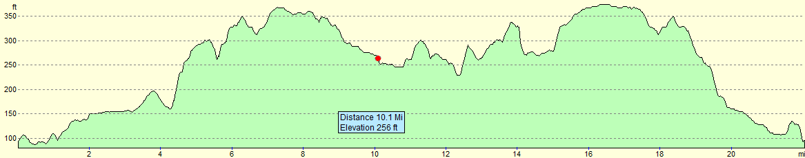
For more information on profiles, ascents and descents, see this page
 |
 |
|
 |
 |
|
 |
 |
|
 |
 |
|
 |
 |
|
 |
 |
|
 |
 |
|
 |
 |
|
 |
 |
|
 |
 |
|
 |
 |
|
 |
 |
|
 |
 |
|
 |
 |
|
 |
Disclaimer
Please note that I take no responsibility for anything that may happen when following these directions. If you intend to follow this route, then please use the relevant maps and check the route out before you go out. As always when walking, use common sense and you should be fine.
If you find any information on any of these routes that is inaccurate, or you wish to add anything, then please email me.
All images on this site are © of the author. Any reproduction, retransmissions, or republication of all or part of any document found on this site is expressly prohibited, unless the author has explicitly granted its prior written consent to so reproduce, retransmit, or republish the material. All other rights reserved.
Although this site includes links providing convenient direct access to other Internet sites, I do not endorse, approve, certify or make warranties or representations as to the accuracy of the information on these sites.
And finally, enjoy your walking!
Nearby walks
| # | Title | Walk length (miles) |
|---|---|---|
| 7 | Waterbeach - Burwell - Swaffham - Waterbeach | 17.1 |
| 8 | Waterbeach to Newmarket | 17.5 |
| 25 | Waterbeach to Cambridge via Quy | 11.0 |
|
|

|