Walk #945: A circular walk from Swavesey to Oakington, Childerley and Boxworth
 |
 |
|
General Data
| Date Walked | 30/01/2012 |
| County | Cambridgeshire |
| Start Location | Swavesey |
| End Location | Swavesey |
| Start time | 08.20 |
| End time | 14.04 |
| Distance | 16.3 miles |
| Description | Sadly this is the worst walk I have done for some time - there was far too much road walking and |
| Pack | Today I carried my 30-litre Karrimor rucksack, filled with water, my waterproofs, a book and other odds and ends. |
| Condition | I feel very fatigued and unwell after this walk, although that was down to an illnes rather than the walk itself. |
| Weather | Today was a rather grey day, with little sign of the sun. Thankfully it remained dry all day. |
| OS map | Landranger number 154 (Cambridge & Newmarket, Saffron Walden) |
 |
 |
|
Map of the walk
Maps courtesy of Google Maps. Route for indicative purposes only, and may have been plotted after the walk. Please let me have comments on what you think of this new format. For a detailed table of timings for this walk, please see the table file.
 |
 |
|
Notes
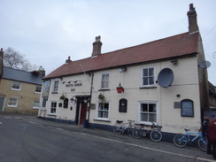
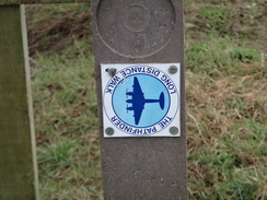
I was expecting todays walk to be a bit of a slog; I had only ten miles to do to complete the Pathfinders Long Distance Walk, but most of these were going to be along roads. I had recovered well enough from my near-marathon walk three days earlier, but the day started badly when I could not find anywhere to park. After driving around the side streets I eventually found a small car park in Market Street in Swavesey, convenient for a shop and the pub.
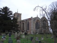
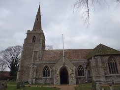
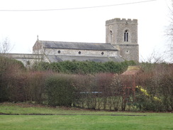
My walk the previous Friday had seen me reach the guided busway that runs along the old Cambridge to St Ives railway line, so my first task was to get back to the point where I had left the trail. This took me past the church, which seems rather large for a relatively small village because it was once part of a priory, the lumps and bumps of which were still easily visible in the field. Many people were waiting for the next bus at the bus stop as I joined the path that runs along the busway.
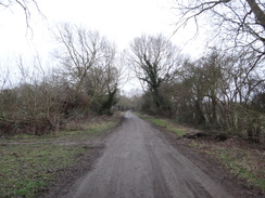
It was not long before I came across the Pathfinders Trail. This led me along a muddy track that passed the church, which was sadly out of view behind the trees, then back to the road in the village. Another path took me alongside a stream on what, on a sunny day, would have been the prettiest stretch of todays walk. Sadly todays weather was overcast and it was hardly at its best with no leaves on the trees. The fact it was still a good stretch shows how poor todays walk was.
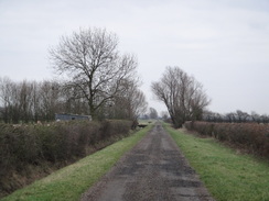
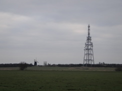
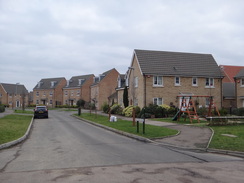
The path soon joined a track called Cow Fen Road which headed across the fen; busses could be seen travelling to and fro along the busway, whilst a windmill and large BT communications mast - the latter like a large Meccano structure - dominated the skyline. The track eventually ended and a path crossed fields before ending at a road. This took me east towards Longstanton, but I came across a new road before the village was reached. This was not marked on my rather elderly OS map but did not prove too much of an obstacle; I followed the new road to a roundabout before heading off along the old road which passes an under-construction housing development.
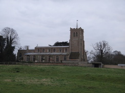
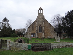
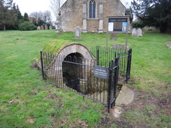
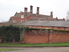
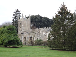
The trail skirted the village itself, eventually joining a road to reach the church. Another road took me southeastwards out of the village, passing the old St Michaels Church, which has a superb towerless Nave. Even better, just outside is an ancient covered well where baptisms were held until the 1880s. It was a highpoint of an otherwise dreary day.
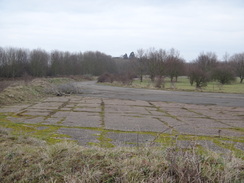
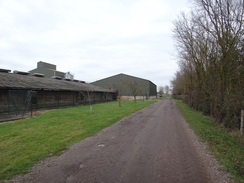
The trail then passed Oakington Barracks, on the site of the old Oakington airfield. My ex-girlfriend used to work at Oakington Barracks when it was an immigration centre and I knew the area well from that time; the road between Longstanton and Oakington passes the western end of the old airfield and barracks. It has always been a bit of a rat-run and is now only open for access, but a number of cars sped down it as I strolled along. Oakington was another of the airfields that the Pathfinder force flew from, designating targets for the bombers following behind.
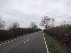
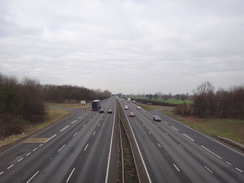
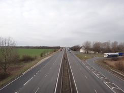
I nipped into a shop in Oakington to buy a few snacks before continuing on to reach a crossroads. What followed was a far from enjoyable stroll along a road towards the A14(T); there was no pavement but the verge was wide enough to allow me to easily walk along it. However there were no views aside from a veritable stream of litter that lined the ditch; fast food and sweet wrappers mixing with drinks cans and unidentifiable pieces of plastic. It was a really unenjoyable stroll.
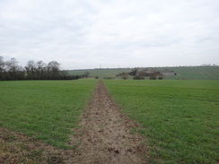
The road climbed to cross a bridge over the A14(T) before diving down the other side to head towards Dry Drayton. The pavement winds through the village along what was obviously the original road, a little bypass taking a less winding route near the church. Shortly after leaving the village the trail joined a path; this was a relief after the many miles of thankless road walking. It descended towards a farm, passing signs warning about shooting in the area, then climbed up a slight hill and followed a hedge. Soon I met a man walking in the other direction; we stopped to say Hello and ended up chatting for more than ten minutes about hillwalking in Scotland. It seemed a strange location to meet a hillwalker considering the flatness of the surrounding terrain.
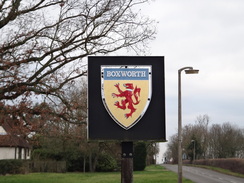
Eventually we parted and I continued on towards Childerley, which meant that I had completed the Pathfinders Long Distance Walk. There was no time to celebrate as I had to get back to Swavesey. Retracing my steps along the trail hardly appealed and so I decided to take a direct route, especially as for some reason I was rapidly running out of energy. I continued along the trail to meet a road, which I then followed north into Boxworth. My condition continued to worsen as my energy levels reached the floor, but I decided not to nip into the village pub as I feared I would not be able to restart the walk if I did.
A road took me north through the pretty village and past the church, which sits away from the road near an impressive-looking house. Sadly this was the last highpoint of the day as the road took me on towards the A14(T), which I re-crossed near the Trinity Foot pub, which is sadly now shut. I have driven past this pub on many occasions and never called in; it is hardly situated in a good position despite the masses of passing traffic and I was therefore hardly surprised that it was shut.
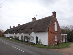
The road continued north past flat fields, eventually entering the southern outskirts of Swavesey. This is a long village that stretches for a couple of miles along the road, and I still had a long way to go. My pace declined once the pavement began and I soon began being passed by a number of women pushing prams. I was now feeling more than a little grotty and it was a relief when my car came into sight once more. It had been the least enjoyable stroll I had done for some time although it did feel good to have finished yet another trail.
 |
 |
|
Directions
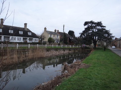
This walk starts off at the car park on Market Street in Swavesey at TL362689. Head past the post office and pub to reach the High Street and then turn right to head north along it. The road soon curves to the right and becomes Station Road; cross over onto the left-hand side and pass a pond on the right. Continue along the pavement as it passes Swavesey church on the left before reaching a level crossing on the guided busway.
Do not cross the level crossing and instead turn left to follow the cycle path that runs alongside the busway westwards. After a quarter of a mile a crossing is reached; here turn left to follow a track called Middle Fen Drive that heads southeastwards for another quarter of a mile until it ends at a T-junction back at Station Road. Turn left up the road for a few yards towards a bridge over a stream. Immediately before the bridge, carefully cross the road and go through a clapper gate to access a field. Cross the field diagonally across towards a second clapper gate. Go through this and follow a hedge and fence on the right, then cross a footbridge over a stream.
On the other side turn right to follow the stream on the right. Ignore a footbridge over the stream and continue on to reach another footbridge; cross this to reach a track Called Cow Fen Road. Turn left to start following this road as it heads eastwards; after a few hundred yards it curves to the right to take a more southeasterly course. The track heads arrow-straight across the fen for 0.8 miles, crossing a bridge over a drain before ending at TL377681.
At the end of the track go through a clappergate beside a field gate to enter a field. Turn slightly to the right to head diagonally across the field, aiming for the far left-hand corner. At the corner of the field cross a footbridge over a stream guarded by two clapper gates. On the other side head across a field, keeping a hedge to the left. At the end of the field go through another clapper gate and cross a footbridge over a ditch to join a road at TL380674.
Turn left to follow the road eastwards; after half a mile it reaches a roundabout that will not be marked on older OS maps. Turn right at the roundabout to head south along the B1050. After a fifth of a mile an old road comes in from the right; carefully cross the B1050 and then turn left through a gap in a wooden fence to access another part of the old road. Follow this as it heads south-southeastwards through the outskirts of Longstanton until a roundabout is reached.
Carefully cross the roundabout and take a footpath that heads southeastwards with a hedge to the left and a field to the right. At the end of the field the path crosses a footbridge to reach Hattons Road, with a cemetery to the left. Turn left along the road for about five yards and then right to follow the edge of another field, soon joining a hedge and ditch on the left. The path soon ends at a road; turn left along this road and follow it until a road junction is reached beside Longstanton Church at TL398663.
Pass the church and then immediately turn right down Woodside Road. Follow this as it heads south-southeastwards out of the village, passing the rather splendid redundant St Michaels church on the left. The road leaves the village and curves to the right and then the left before passing the western edge of the old Oakington airfield. 1.5 miles after passing Longstanton church, the road enters the village of Oakington. Continue along the road as it passes a pub on the left and a shop on the right before it ends at a crossroads at TL410642.
Turn right to start following Dry Drayton road southwestwards; the pavement ends after a while so you have to follow the verge. The A14(T) is reached after a mile; ignore slip roads off to the right and follow the road as it curves to the left and then right, climbing to reach a bridge over the dual carriageway. Cross the bridge and follow the road as it swings around to end at a junction with another road. Turn left to follow the road southwestwards; again there is no pavement but the verges make the going easy. Keep on the road as it enters the village of Dry Drayton; a mile after the A14(T) is crossed, cross a mini-roundabout and continue on along Park Street until Dry Drayton church is reached on the left at TL380620.
Continue past the church to a second mini-roundabout. Here turn half-left along the road. Just before the houses on the right end, turn right down a footpath that squeezes down a narrow path between hedges. When the hedges end the path crosses a footbridge to enter a field. Turn slightly to the left to follow the path downhill, aiming just to the left of the buildings of Rectory Farm. Cross a footbridge over a ditch at the bottom of the field and then turn left for a short distance to reach a track.
Cross this track and continue straight on; the path heads between two fields and under some power lines. When a junction with another track is reached beside a little rob-pit, turn right along another path that runs between two fields. At the end of the fields cross a ditch and go through a hedge, then turn left to keep the hedge on the left. The corner of the field is reached after about thirty yards; turn right and follow a hedge on the left.
The path summits a little hill before descending, still beside the hedge, until it meets a track. Head straight on along this track as it enters a small patch of woodland, curving to the right before leaving the trees. It then curves to the left to head southwestwards for a quarter of a mile towards Childerley. It passes some cottages on the right and curves slightly to the left and then right until a track junction is reached near Childerley Hall at TL356616. Turn right to follow a track that heads north between barns before curving to the left and then right to pass barns on the left. At the end of the barns turn left past the end of the barns; the track then curves to the right.
The track follows a hedge on the left, heading towards some power lines ahead. As the track starts to gently curve to the left, turn left through a gap in a hedge that follows a path with a hedge on the left. Go through a gap in the hedge at the end of a field and cross a plank footbridge to reach another field. Follow a hedge and ditch on the right; at the end of this second field go through another gap in a hedge to join the edge of a concrete track. Follow this westwards until it reaches a minor road at TL344622.
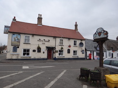
Here the Pathfinder Long Distance Walk is left. Turn right to follow the road as it heads northwards; it soon passes under some power lines. It maintains the same rough northerly direction as it twists and turns before ending after 1.1 miles at a T-junction with another road opposite The Golden Ball pub in Boxworth at TL344640. Turn right to start following another road as it heads northeastwards through the village, twisting and turning and passing near to Boxworth church before leaving the village. 1.3 miles after the pub, a roundabout is reached near the A14(T) with a service station off to the right.
Turn left and follow a road that swings around to the right, climbing uphill to cross a bridge over the dual carriageway. On the other side the road swings to the left before ending at a T-junction with another road, with the A14(T) a short distance away to the left. Turn right to start following the road as it heads in a rough north-northeasterly direction; there is no pavement but the verges are wide. After a mile the road enters the southern outskirts of Swavesey and soon afterwards a pavement starts on the right. This swaps over onto the left-hand side of the road; continue north through the village for another mile until Market Street is reached on the right, where this walk ends.
 |
 |
|
Distances
| From | To | Distance (m) | Ascent (ft) | Descent (ft) |
|---|---|---|---|---|
| Swavesey | Dry Drayton | 8.7 | 115 | 26 |
| Dry Drayton | Swavesey | 7.6 | 167 | 256 |
This makes a total distance of 16.3 miles, with 286 feet of ascent and 282 feet of descent.
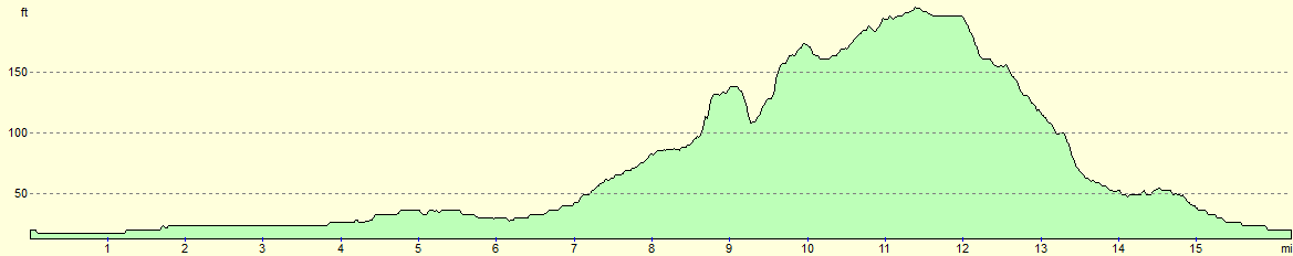
For more information on profiles, ascents and descents, see this page
 |
 |
|
 |
 |
|
 |
 |
|
 |
 |
|
 |
 |
|
 |
 |
|
 |
 |
|
 |
 |
|
 |
 |
|
 |
 |
|
Disclaimer
Please note that I take no responsibility for anything that may happen when following these directions. If you intend to follow this route, then please use the relevant maps and check the route out before you go out. As always when walking, use common sense and you should be fine.
If you find any information on any of these routes that is inaccurate, or you wish to add anything, then please email me.
All images on this site are © of the author. Any reproduction, retransmissions, or republication of all or part of any document found on this site is expressly prohibited, unless the author has explicitly granted its prior written consent to so reproduce, retransmit, or republish the material. All other rights reserved.
Although this site includes links providing convenient direct access to other Internet sites, I do not endorse, approve, certify or make warranties or representations as to the accuracy of the information on these sites.
And finally, enjoy your walking!
Nearby walks
| # | Title | Walk length (miles) |
|---|---|---|
| 2 | Waterbeach to Newmarket Road, Cambridge | 5.4 |
| 5 | A short walk around Waterbeach to Car Dyke | 3.0 |
| 6 | Waterbeach to Newmarket Road, Cambridge | 5.4 |
|
|

|