Walk #218: Prickwillow to Newmarket
 |
 |
|
General Data
| Date Walked | 02/09/2002 |
| County | Cambridgeshire, Suffolk |
| Start Location | Prickwillow Church |
| End Location | Newmarket bus station |
| Start time | 08.10 |
| End time | 14.15 |
| Distance | 15.5 miles |
| Description | This was a walk of two halves; the first being a walk along the bank of the River Lark and the second a nice walk along roads and footpaths southwards to Newmarket. |
| Pack | Today I carried my 30-litre Karrimor Hotrock rucksack, which contained a fleece, some paperwork and a book. It also contained the usual assortment of odds and ends and had two litres of water in it, carried in a 2-litre Platypus container. |
| Condition | For the first time in a while I have had trouble with my feet. I used my new Scarpa boots for this walk, and fairly early on I could feel trouble with my toes. By the end of the walk they were aching, and when I got home I discovered that I had blisters on the two smallest toes on each foot. I put this down to the fact that I was wearing two pairs of socks on this walk, the outermost being fairly thick, and the fact that I had not cut my toenails for some time, which was causing my toes to be squashed together. Aside from this I did not have any trouble on this walk, and my legs and back felt fine. |
| Weather | The forecast for today was for sunny periods, and so I decided to leave my coats at home. When I started off on the walk there were heavy clouds overhead, and in the distance I could see rain falling. Later on in the walk there were periods of light drizzle and even a few minutes of rain, but none of these got me very wet and I soon dried off. As the day went on the clouds parted and there were a fair few sunny periods, which with a gusting wind helped me dry off. |
| OS map | Landranger number 143 (Ely & Wisbech, Downham Market) and Landranger number 154 (Cambridge & Newmarket, Saffron Walden) |
 |
 |
|
 |
 |
|
Map of the walk
Maps courtesy of Google Maps. Route for indicative purposes only, and may have been plotted after the walk. Please let me have comments on what you think of this new format. For a detailed table of timings for this walk, please see the table file.
Notes
This was an enjoyable little walk, which combined footpath, road and riverside walking. The only slight problem was the weather, which for the first part of the journey promised to be wet, but fortunately although there were a few short showers of drizzle it never really managed to rain properly.
Prickwillow is a nice little village, and the church is quite neat, with a short, stump spire and no tower. The course of the River Lark was straightened in 1829 and this allowed the village to develop. The place now occupied by the village used to be open Fenland with Oiser beds but after the river was straightened houses could be built on the silt of the old river bed, or Rodham. The first house was the Toll House, which was built in 1830 and is on the riverbank opposite the museum. This building was used to collect tolls from boats using the river. The pumping station, which is now the museum, was built in 1880 and used a steam-powered beam engine to pump water into the river.
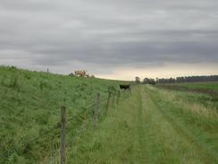
The section of path along the River Lark was a quite nice little walk that I would probably have enjoyed more if it had not been very gloomy overhead and had not been threatening to rain. The views of the river from the top of the bank are nice in places, but in others are obscured by reeds and weeds, and when by the banking the river is not visible and the only views available are head and behind, with occasional glimpses of the flat farmland to the west.
In Isleham I stopped off at the small post office, where I bought myself some AAA batteries, a pack of crisps and a chocolate bar to munch on. The Parish Church of St Andrew in Isleham is very nice and quite imposing, with an unusual double lych gate leading into the churchyard and a nice circular tower. Elsewhere in the village there are the Lady Francis Alms Houses, which are very nice and were founded in 1580, rebuilt in 1842, 1959 and 1982. It could be argued that the number of times they have needed to be renovated in modern years shows the quality of modern workmanship
I stopped for a break in the Thorp Arms pub in Chippenham, where I had a pint of Abbott and a packet of crisps. When I entered the locals in the pub enquired about what I was doing with all the gear on, and when I told them we ended up having a long conversation, which is why I spent longer than usual in the pub. The pint of Abbott caused me to have a slight swagger to my walk for twenty minutes after the pub stop, but was highly enjoyable nonetheless.
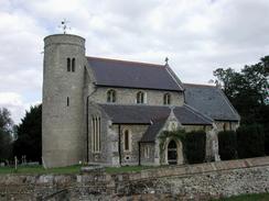
St Peter's Church in Snailwell is a lovely little church, and is yet another round-towered church, which are more or less unique to this area. It is in a beautiful setting beside the River Snail and is a very tall church, with the roof nearly meeting the top of the round tower.
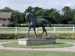
As Newmarket is approached signs of the chief industry of the town, horseracing, become visible. Outside Snailwell Stud there is a lovely statue of a racehorse, and once the outskirts of the town are entered there are signs proclaiming the famous Godolphin Stables. Strangely enough I did not see many horses on this walk; this is probably because thoroughbreds are kept in areas away from the public.
Directions
This walk starts off at Prickwillow Church, in the village of Prickwillow, which lies between Ely and Lakenheath. From the church, turn left and walk down the B1382 road for about twenty yards and then turn right just before the bridge over the River Lark is reached signposted for the Drainage Museum. Follow this road around as it swings past the museum and then take a footpath which leads off to the left just before you get to a farm.
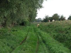
The footpath leads off to the northeast along a green track, which runs at the bottom of the tall banking of the river. Shortly the river curves around to the right to head southeastwards and the bank and track follow it. After a while I reached the remains of a decrepit wooden cattle fold. I managed to climb up on top of the bank here and could follow the path that ran along the top. The rest of the way beside the river to Isleham was either on the top of the bank or on the track, which ran along the bottom, and I often changed from one to the other. The map shows the footpath as running at the top of the bank, but in places this is blocked off or overgrown so at these times the track was the easiest option.
The River turns slightly to head south-south-eastwards for a few miles until it approaches Isleham. Here the river turns to head south-eastwards until it meets a tarmac road near Isleham Marina, where the road is joined and can be followed as it heads southwards into Isleham. The bank turns to follow the road, and it slowly gets lower and lower as the entrance to Isleham Marina is approached until eventually it is barely significant. The initial stretch of this road is called Fen Bank, but once the houses start appearing on the right it becomes known as Waterside.
When Waterside ends at a T-junction turn right down Sun Street and follow it as it winds its way westwards until it ends at a T-junction. Isleham Church is a few yards down Church Street to the right, and is well worth a visit. If you do not want to visit it then turn left out of Sun Street down The Causeway. Pass to the left of a graveyard with the pretty Lady Francis Alms Houses to the right and turn right down Beck Road, with cemeteries on both side of the road.
The road bends to the left and continues on out of the village, signposted for West Row and Mildenhall. Pass a road junction to the left and continue straight on, climbing up a little hump in the road to where the old Cambridge to Mildenhall railway line used to cross the road. Descend down the other side of the hump and when the road turns to the left to cross over Lee Brook take an old road to the right that ends at a removed bridge over the stream.
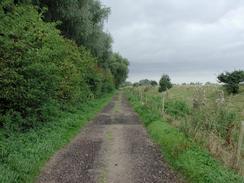
At the stream turn right past a grey cabin down a bridleway which initially follows the western bank of the stream and heads under some power lines. After a short distance the path turns to the right along a field boundary and then to the left after thirty or forty yards. The bridleway then heads down a scenic green lane between two hedges. After a while the bridleway joins a wide track that comes in from the right and continues on southwards, passing a farm on the right. The track becomes better quality as it progresses, and is known as Mortimer Lane and ends at the B1102 road in Freckenham.
Turn left down the B1102 and then immediately to the right, to head down Chippenham Road. This leads out of Freckenham and heads southwards to meet the B1104 Isleham Road. Turn left along the B1104 and follow it south-south-eastwards as the B1085 road comes in from the right and the road enters the village of Chippenham along High Street.
In Chippenham turn right along Palace Lane and follow this south-westwards out of the village, with a large wall marking the boundary of Chippenham Park to the left of the road. When the road turns to the left take a footpath that leads off to the right. This follows to the left of a hedge for a short distance, and when the hedge ends it turns to the left and follows a track across the fields under some power lines.
The path heads towards some woodland that marks the south-eastern edge of Chippenham Fen Nature Reserve. The path skirts the woodland before meeting a track that leads south-eastwards to Oak Farm. Cross over this track and continue straight on along the footpath to the southwest. The power lines overhead soon end in the next field, but the path continues on along he track, which is still well defined. It passes through a narrow band of woodland and continues straight on across a wide field until it meets two hedges end-on. The path continues between these hedges for a short distance until it ends at a T-junction with a Fordham Road.
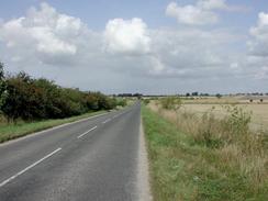
Turn left down the road and follow it southwards into the little village of Snailwell and becomes The Street as it enters the village. Pass to the left of the George and Dragon pub, which has a very nice sign outside it, and then to the right you meet Church Lane, down which can be found St Peter's Church. Past Church Lane The Street becomes The Green, and then reaches the village green. As the road forks at the green take the right-hand fork that ends at a road. Turn right down this road and then follow the road as it curves around to the left to head towards Newmarket along Newmarket Road.
The road descends downhill past Snailwell Stud and at the bottom of the hill it passes under the A14(T) road. It then passes the entrance to the British Racing School to the left before passing under a railway line. The road continues southwards and becomes Snailwell Road and passes stables on either side, including the famous Godolphin Stables.
When the road ends at a T-junction with the A142 turn left and follow the A142 southwards into the town centre. Just before a roundabout is reached turn right down Fred Archer Way and then as the road curves to the left continue straight on down the road, which is still called Fred Archer Way. The Rookery shopping centre is on the left, and the bus station is directly outside the centre.
Distances
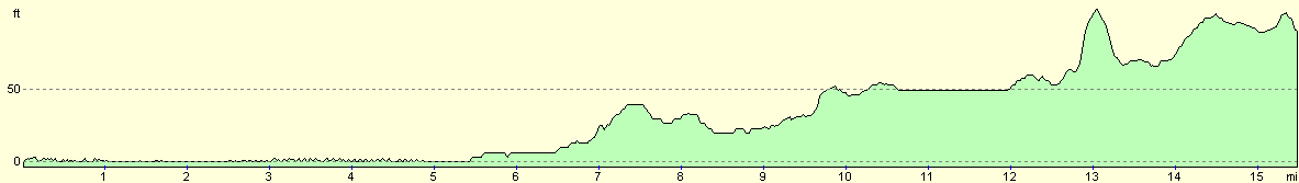
| From | To | Distance (m) | Ascent (ft) | Descent (ft) |
|---|---|---|---|---|
| Prickwillow | Isleham | 7.1 | 131 | 108 |
| Isleham | Snailwell | 5.7 | 98 | 59 |
| Snailwell | Newmarket | 2.7 | 98 | 72 |
This makes a total distance of 15.5 miles, with 327 feet of ascent and 239 feet of descent.
For more information on profiles, ascents and descents, see this page
Transport
Transport is slightly difficult on this walk. There are regular bus services on the X11 every half hour during the day from Newmarket to Cambridge, from where trains or bus services can be taken to Ely. From Ely there are some bus services serving Prickwillow, but these are not regular. Alternatively you could get the X11 bus to Bury St Edmunds, from where there are train services to Ely but you are still faced with the problem of getting to Prickwillow. I got around these problems by getting my girlfriend, who works near Ely, to drop me off first thing this morning.
Disclaimer
Please note that I take no responsibility for anything that may happen when following these directions. If you intend to follow this route, then please use the relevant maps and check the route out before you go out. As always when walking, use common sense and you should be fine.
If you find any information on any of these routes that is inaccurate, or you wish to add anything, then please email me.
All images on this site are © of the author. Any reproduction, retransmissions, or republication of all or part of any document found on this site is expressly prohibited, unless the author has explicitly granted its prior written consent to so reproduce, retransmit, or republish the material. All other rights reserved.
Although this site includes links providing convenient direct access to other Internet sites, I do not endorse, approve, certify or make warranties or representations as to the accuracy of the information on these sites.
And finally, enjoy your walking!
Nearby walks
| # | Title | Walk length (miles) |
|---|---|---|
| 3 | Littleport to Downham Market | 14.0 |
| 7 | Waterbeach - Burwell - Swaffham - Waterbeach | 17.1 |
| 8 | Waterbeach to Newmarket | 17.5 |
|
|

|