Walk #219: Rushden to Bedford
 |
 |
|
General Data
| Date Walked | 04/09/2002 |
| County | Northamptonshire, Bedfordshire |
| Start Location | Rushden |
| End Location | Bedford long-stay car park |
| Start time | 10.42 |
| End time | 17.10 |
| Distance | 15.4 miles |
| Description | This was a nice walk through some pretty little villages. Unfortunately it was spoilt by the fact that I was not feeling very well, and so I was concentrating more on finishing than doing any exploring. |
| Pack | Today I carried my 30-litre Karrimor Hotrock rucksack, which contained a fleece, waterproof coat and trousers. It also contained the usual assortment of odds and ends including a book. It also had two litres of water in it, carried in a 2-litre Platypus container. |
| Condition | I felt ill even before I started this walk, and the feeling only got worse as the walk went on. I had some blisters on my little toes after the last walk, and these caused me to walk slightly unusually at first. This in turn put extra strain on my ankles, and my left ankle gave twinges accordingly. At times I was feeling slightly nauseous, and this made the walk all the harder. I was sweating profusely at the start of the walk despite the fact that it was not yet hot, and this was another symptom of the fact that I was feeling ill. On the positive side I have no new blisters. |
| Weather | The weather today started off cloudy, but this soon cleared so that there were some long sunny periods. There was very little wind, and it ended up being a reasonably warm day. There was no sign of any rain, and all in all it was a lovely day for a walk. |
| OS map | Landranger number 153 (Bedford & Huntingdon, St Neots & Biggleswade) |
 |
 |
|
 |
 |
|
Map of the walk
Maps courtesy of Google Maps. Route for indicative purposes only, and may have been plotted after the walk. Please let me have comments on what you think of this new format. For a detailed table of timings for this walk, please see the table file.
 |
Notes
The day started off badly when I found it difficult to find a long-stay car park in the centre of Bedford. The first car park I tried turned out to only allow stays of a few hours, so I had to get back in my car and find another. After driving around the confusing one-way system I eventually found the multi-storey long-stay car park at Princes Street. Then when I eventually parked I needed the toilet, and I cold not work out where I was in relation to the city centre. I managed to find my way and the first public toilet I cam across - one of the space-age self-cleaning ones - was out of order. Increasingly in need of relief, I walked further into the centre and a few minutes later found a very dinghy public convenience at the corner of Silver Street.
When I reached the bus station I discovered that a bus to Rushden was due to go on a few minutes, so I decided too get the bus to that town and to walk back to Bedford from there. Unfortunately the bus was ten minutes late, and when I was getting off the bus in Rushden I damaged my Dictaphone. This still worked, but the tape compartment does not lock shut and opens if the Dictaphone was shaken. To make matters worse, on the bus journey I had started feeling quite ill and was starting to wonder if the walk was such a good idea.
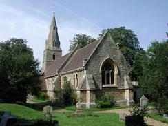
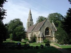
This walk was dominated by the number of churches that I visited en-route. They were all good examples of church architecture, and in particular the one in Souldrop was very nice and was set in a beautiful setting. St Lawrence Church in Wymington is also very nice, with some pretty castellated towers at the end of the nave. The main tower is quite ornate, and the whole church blends in nicely with the churchyard.
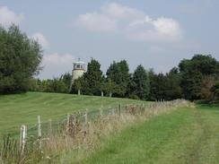
The church of St Peter in Sharnbrook was also very nice, with plain buttresses leaping from the pinnacles to the spire. Again the setting was nice, although the church is much larger than the previous couple on this walk. Is topped off at a shop in the village so that I could buy a Callipo ice lolly in a vain attempt to try and keep myself from overheating. There was also a pub in the village, The Swan with Two Nicks, which is a name that I have never seen before and I found it most intriguing. There is a windmill on the map to the southeast of the village, but unfortunately this now no longer has any sails and has a glass cabin at the top of it, which looked slightly incongruous,
On the village green in Souldrop there was a beacon, which was engraved with a lovely little poem which unfortunately I did not record. The church itself was very nice and was in a lovely setting, with the nearby trees enhancing the building and not detracting from it. The weathercock on top of the spire shone golden in the sunlight, and the view from the tree-lined path leading towards the church was exquisite.
By the time I got to Pavenham I was in need of a rest, but when I made a detour to the pub in the village I found that it was shut. I decided to continue on, and eventually stopped at the Fox and Hounds pub in Clapham, which is beside the A6, where I managed to have a pint of orange and lemonade and a twenty minute rest.
The road between Oakley and Clapham was being worked in as part of the A6(T) Clapham bypass, which split the road into two. There were two new roundabouts and the road had been diverted over the bypass on a new bridge. The road underneath looked like it was nearing completion, and it was a hive of activity with man and machine working together. I was surprised to find later on that the road was not due to open until the next spring as it looked much nearer completion than that timescale would suggest.
Although in many ways this walk was spoiled by the fact that it did not go well, I am fairly elated nonetheless because I managed to complete the walk despite these difficulties. After a fair few days of easy walking, in a way it is nice to have a hard one to have to endure and know that I can do it.
Directions
This walk starts off at St Mary's Church in Rushden. Turn left and head down the A6(T), passing to the right of the war memorial as it turns to the left to head southwards towards Bedford. Pass Townsends Garage and then turn right down Wymington Road. Follow Wymington Road as it climbs uphill and passes Rushden Hospital.
By South End Primary School there is a mini roundabout. Continue straight on and follow the road over the border between Northamptonshire and Bedfordshire before it descends down into Wymington as the road becomes Rushden Road. Turn left up Church Lane and pass St Lawrence Church on the left. Follow the lane as it passes the memorial hall and turns to the right to end at a T-junction with a road.
At the junction turn left to head eastwards out of the village. The road climbs uphill and slowly turns to the right. Once this bend has finished it turns sharply to the left, where a track leads off straight on. Head down this track as it enters the Goosey Lodge Estate. Pass to the left of a barrier gate and weighbridge with warehouses behind and take the right-hand track that leads down to Goosey Lodge.
After Goosey Lodge the map shows the footpath going clearly to the right of the track; I found that this route was impossible due to there being no way though the hedge at the top of the next field. I would suggest that you try using the track to get to North Lodge and then Blackmere Farm. Once I found that the hedge was impassable I turned to the right and followed the hedge to see if there was a way through. There was not, but at the right-hand (southwestern) edge of the hedge there was a gate leading through into the next field. I climbed over this gate and on the other side there was a clear, good track leading roughly in the right direction. I turned left and followed this track as it skirted the south-western edge of a little area of woodland and then reached a track next to Blackmere Farm.
Turn left towards Blackmere Farm along a track and go through the farmyard. The track turns to the right to head south-eastwards for a short distance until it ends at a T-junction with another track along which turns the Three Shires Way. Turn left along this track and follow it as it turns to the right and becomes a surfaced public road, called Forty Foot Lane.
Follow the lane as it heads southwards into Souldrop and becomes Chapel Lane as it enters the village. At a village green take the left-hand branch and pass to the right of the Bedford Arms pub and reach another village green, upon which is a beacon with an engraved plaque on it. At this green turn right down Sharnbrook right, and a little further on there is a footpath that leads off to the right towards the church.
Continue on along Sharnbrook Road southwards as it turns to the right to pass over the Midland Main Line railway, immediately after which it turns to the left and descends downhill through a tree-lined stretch of road. The road then curves to the right and passes Tofte Manor before entering the village of Sharnbrook.
In Sharnbrook the road passes the junction with Colworth on the right and becomes High Street. Continue on along the High Street past the junction with Church Lane which heads off to the right up to Sharnbrook Church.
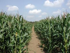
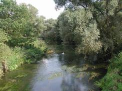
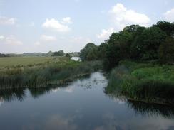
Continue on along High Street past a shop and the Swan with Two Nicks pub. When the road turns to the left to head eastwards take a bridleway that leads off to the right. Follow this bridleway as it skirts to the left of a hedge and then go through a gate and across a tiny stream into the next field. Continue straight on through this field, which when I visited was full of Maize that was taller than me, and eventually it reaches the south-eastern corner of a nature reserve. The bridleway then follows the southern edge of the reserve for a short distance before crossing over the first of two bridges over a stream and turning to the left to meet a track that runs beside the River Great Ouse. Turn right down this track and follow it south-westwards to an attractive five-arch bridge over the river.
When the track ends at a road turn left and cross over the river using the bridge and follow the road as it passes the church. Head up a alight hill and take the first road to the right, Grange Road, which heads downhill past the Sun pub. Opposite the pub take Pavenham road that leads off to the left. The road leads out of the village and climbs uphill to an area of woodland before descending downhill into Pavenham, where the road becomes Church Lane.
Pass Pavenham Church and continue on until the road ends at a T-junction. At the junction turn left past the war memorial and follow the road eastwards for a mile until it turns sharply to the right to head southwards. It heads downhill and then turns to the left to skirt the River Great Ouse until it crosses the river at Stafford Bridge.
On the other side of the bridge the road climbs uphill to enter the village of Oakley. At the top of the hill continue on along Station Road and pass to the left of a school until the road ends at a T-junction. At the junction turn left towards Clapham along Lovell Road. The road passes under the railway line and then gets to a roundabout. Continue over the roundabout and follow the road as it climbs over the A6(T) Clapham Bypass and reaches another roundabout on the other side of the bridge. At this roundabout turn right and descend to follow the road towards Clapham.
When the road ends at a T-junction with the A6(T) High Street turn right down the A6(T) and pass the Star Pub, the Horse and Groom Pub, and then the Swan Pub and a war memorial where High Street becomes Bedford Road. There is a cycle path and footpath beside the road that means that it is a fairly safe walk. The road passes under some power lines and then rises up past the Anglers Rest pub to a new roundabout where the A6(T) Clapham Bypass leads off to the right.
At the roundabout turn left and proceed for a short distance south-eastwards to another roundabout. Cross over this roundabout and continue straight on along Clapham Road to another roundabout. At this roundabout turn right down Union Street. Cross over the A428 and continue on along Greyfriars. The bus station is straight ahead at the next roundabout.
To get back to the car park that I stayed at turn right at the roundabout down Greyfriars and use the pedestrian crossing to cross over to the left-hand side of the road. Continue south down Greyfriars and then turn left down a pedestrianised road called Silver Street. At the end of Silver Street turn left down High Street, passing to the left of an impressive statue of John Bunyan. Continue on until the church of St Peter de Merton with St Cuthbert is reached on the right; at this point turn left and cross the road to a building with benches all around it. Cross over De Parys Avenue and then turn right down Foster Hill Road and then turn left up Princes Street. The long-stay car park is a little distance to the left along this road.
Distances
| From | To | Distance (m) | Ascent (ft) | Descent (ft) |
|---|---|---|---|---|
| Rushden | Sharnbrook | 6.0 | 256 | 289 |
| Sharnbrook | Oakley | 5.3 | 253 | 285 |
| Oakley | Bedford | 4.1 | 85 | 125 |
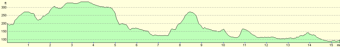
This makes a total distance of 15.4 miles, with 594 feet of ascent and 699 feet of descent.
For more information on profiles, ascents and descents, see this page
Transport
There are regular bus services between Bedford and Rushden on the Stagecoach X52 route. There are also other services between the two towns which also serve village en route. The bus cost me two pounds fifty for a single ticket.
Disclaimer
Please note that I take no responsibility for anything that may happen when following these directions. If you intend to follow this route, then please use the relevant maps and check the route out before you go out. As always when walking, use common sense and you should be fine.
If you find any information on any of these routes that is inaccurate, or you wish to add anything, then please email me.
All images on this site are © of the author. Any reproduction, retransmissions, or republication of all or part of any document found on this site is expressly prohibited, unless the author has explicitly granted its prior written consent to so reproduce, retransmit, or republish the material. All other rights reserved.
Although this site includes links providing convenient direct access to other Internet sites, I do not endorse, approve, certify or make warranties or representations as to the accuracy of the information on these sites.
And finally, enjoy your walking!
Nearby walks
| # | Title | Walk length (miles) |
|---|---|---|
| 142 | Huntingdon Station to Hargrave | 17.3 |
| 184 | A circular walk between Hargrave, Raunds and Rushden | 18.4 |
| 213 | Rushden to Northampton | 16.4 |
|
|

|