Walk #184: A circular walk between Hargrave, Raunds and Rushden
 |
 |
|
General Data
| Date Walked | 13/04/2002 |
| County | Bedfordshire, Northamptonshire, Cambridgeshire |
| Start Location | Hargrave |
| End Location | Hargrave |
| Start time | 08.35 |
| End time | 16.27 |
| Distance | 18.4 miles |
| Description | This enjoyable walk had two purposes; to get used to a full pack prior to my big walk in Scotland next week, and to visit Huntingdonshire's highest point, which I failed to do last year. In the process I have completed two of my planned walks; the short one from Hargrave to Ruands and a slightly longer one from Raunds to Rushden. |
| Pack | This was probably the heaviest pack that I have carried in years. It was full Pennine-Way spec kit, with 10 days food stored within it. This was very heavy, but it was well balanced and it did not feel as heavy as it did during my last trip out with full kit. After the walk I weighed it and it was 53 pounds - well over the 45 pounds that I carried on the Pennine Way. If I figure on carrying a maximum of 55 pounds fully loaded on the trip to Scotland then I will be happy - as I use up food my pack will only get lighter. |
| Condition | Considering the fact that I am still recovering from the bout of the flu that I have had for a fortnight, I am very pleased with my condition after this walk. I have taken my time, took some fairly regular breaks and am not very fatigued. I have a couple of hot-spots on my left foot, but I do not think that these will turn into blisters. My shoulders ache slightly, but not as much as I was expecting them to. |
| Weather | The weather today was reasonable, with sunny periods interspersed with some dark clouds. There were a few little periods of spitting rain, but there was not enough of this to get me to consider getting my coat out of my pack. What was of slightly more concern was the wind, which was gusting at times and made me slightly cold when the sun was behind cloud. |
| OS map | Landranger number 153 (Bedford & Huntingdon, St Neots & Biggleswade) |
 |
 |
|
Map of the walk
Maps courtesy of Google Maps. Route for indicative purposes only, and may have been plotted after the walk. Please let me have comments on what you think of this new format. For a detailed table of timings for this walk, please see the table file.
Notes
This was a walk that I had been intending to do for quite a while, but it had always been low in my priority list. I finally got around to doing it because I needed a long and fairly flat walk to do to try out my full-weight pack for the first time, prior to my going out on my big trip to Scotland next week. After looking at various alternatives and realising that I did not fancy driving a great distance today, this was the walk that I came up with. It also had the advantage of being circular, so if I did feel tired earlier than expected I could fairly easily reduce the total distance.
I am still recovering from the bout of flu that prevented me from doing my planned walks over Easter, and so I was very worried about my fitness levels. Fortunately although I coughed a few times (the only remaining symptom of the flu that I am exhibiting) I was mostly okay, although I did feel slightly nauseous for two short periods. One of these was very early on in the walk whilst I was on my way to Raunds, so I was glad when that bout of queasiness stopped.
I stopped off for a pint of Abbott Ale and a pint of orange and lemonade at the Chequers Pub in Yelden. This was a really nice pub with some very friendly people in it. I had a lovely baked potato with beans, bacon and cheese, which probably gave me enough carbohydrate to help me finish the walk. When I got up to leave some people asked me what I was carrying all that weight for, and they wished me luck when I told them about next week's walk. It is this sort of friendliness that really adds a certain something to any walk. There is a big military listening post on the hilltop immediately to the north-northwest of the village which used to be an airfield in the Second World War, and the bar I was in was festooned with memorabilia from the airfield, and indeed reunions have been held at the pub. There were a couple of nice model airplanes hanging from the ceiling which I studied for a while.
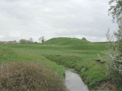
The scenery on the walk was not very dramatic, but some nice views were available to the south during the last part of the walk back to Hargrave. Raunds and Rushden were fairly undistinguished, although I only got to see the very southern part of Raunds as I did not voyage into the town centre. Some of the villages on the route, however, are quite nice - Newton Bromswold, Yelden and Shelton were all fairly picturesque little villages. Yelden even has a motte and baileys from a castle, sadly with no stonework remaining, but it was a far more impressive site than the old castle mound in Cambridge.
On a previous walk last year I thought that I had reached the highest point of Huntingdonshire. A little research later, I found that I had been about 400 metres of the highest point. When I got back to Hargrave I decided to drop off my pack and do the little walk to try and find the highest point. The point is at a place called Boring Field, which is quite apt because it is the lowest of all the county tops at only 263 feet. There is a much more interesting point nearby, however, as opposite the water tower at Three Counties House is a stone that shows the place where the three counties of Huntingdonshire, Northamptonshire and Bedfordshire meet.
In Rushden I passed the abutments of a long-removed railway bridge, and was surprised to see a railway semaphore signal and a carriage at the end of the abutment. I made a little diversion up a road to the left to find the Rushden Historical Transport Society based in the old Rushden Station. This was quite a nice surprise, and I had a quick look at the steam and diesel locomotives which were present between the station platforms.
On the way back to the car to drop off my pack before tackling the little diversion to Boring Field I met a couple in Hargave. I was walking on the other side of the road and as I walked past me they said something to me. I had my walkman om, listening to the football match between Derby and Newcastle. I crossed the road and the lady enquired if I was the person who had left a car by their drive. I immediately apologised, but she brushed it off and said that they had been curious about who had left the car there- they had seen me get out with a large pack and they thought I might be in the army! They were intrigued about what I was training for, and when I told them they wished me luck and talked to me for another few minutes. This was yet another welcome sign which made me feel much better.
This walk sets me up well to walk westwards from Rushden towards Northanpton, and south from Rushden to Bedford. These two walks are not a very high priority for me at the moment, however, so I will probably not get around to doing them this year. I really find it hard to look that far ahead - my mind is filled with the imminent walk in Scotland, and my whole life is revolving around the planning and organisation of that walk.
Directions
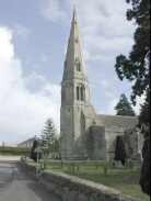
This walk starts off by the church in Hargrave, a little village to the south of the A14 between Huntingdon and Kettering. The village is very quiet, and there is plenty of on-road parking. From the church head north along a road and then immediately turn left to head west along the northern side of the church.
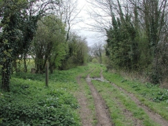
The road heads down a very slight hill until it crosses a small stream. On the opposite side of the stream two footpaths head off to the left; ignore the first one which actually runs down the bed of the stream and take the second one. Cross the first field to a gap about halfway down the hedge on the right-hand side. Go through this gap and follow the footpath as it heads westwards across the fields until it meets another road at a junction.
Three roads leads off from this junction; continue straight on along a road that heads in a rough south-northwesterly direction for nearly two miles into the town of Raunds.
When the road ends at a T-junction with the B663 road in Raunds (by the town hall), turn left and follow the B663 road southwestwards until a roundabout is met. Continue straight on at the roundabout to head southwestwards for a mile into the village of Stanwick.
Walk past the church in Stanwick and follow the road as it bends around the church and descends down a slight hill to a road junction. At the road junction continue straight on for a short distance along a road that ascends a slope, and which then turns to the right. The road twists around before finally exiting the village to the south.
The road continues for a little over a kilometre until a sharp right-hand bend is reached near Chelveston Lodge. Just after the bend a footpath leads off to the southwest, descending into a valley to cross a stream before ascending again to meet a road on the outskirts of a housing estate in Higham Ferrers. These directions could change soon however, as fences had been put up for a new major road that is going to run past the housing estate; hopefully the footpath will have a traffic-free route.
When the footpath emerges into the housing estate turn left along a road. When this road ends at a T-junction continue straight on to the south down another road. When this road ends at a T-junction turn right and then take the first road to the left, to emerge at the B645 road.
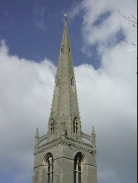
Cross the B645 road and continue straight on down another road which leads past the attractive church. After the church the road bends around to the right and ends at a T-junction with the A6(T) road in the centre of Higham Ferrers.
Turn left and head southwards down the A6(T) for a couple of kilometres, passing the junctions with the A5028 and B569 road. Shortly after the abutments of an old railway bridge are passed the A6(T) turns to the right. Leave the A6(T) and continue straight on until a road in front of Rushden Church is reached.
At the church turn left and follow a road that heads uphill. Cross over a road at some traffic lights and continue eastwards uphill along a road. At the top of the hill a cemetery is passed, and shortly after this the housing peters out and the countryside begins. Rectory farm is then reached on the left, and shortly after this a footpath leads off to the left. Take this footpath as it heads in a roughly easterly direction across fields to meet a road immediately to the southwest of the little village of Newton Bromswold. The initial part of this footpath was easy to follow, with a nice wide track leading on to a cleared footpath through the crops. Halfway along the route, however, there was no route through the crops so I was forced to divert around the edge of the fields to find the stiles.
Once the road is reached turn left to head northeastwards into Newton Bromswold. When the road ends at a T-junction turn right and then almost immediately left to head northeastwards along another road. After about a kilometre this road turns to the right to head eastwards before turning to the left once more to head north into the village of Yelden. About halfway up the village on the right is a nice pub where I had lunch.
Continue straight on through the village, passing the Motte and Baileys of an old castle on the right. The road ends at a junction by the northern end of the earthworks. At this junction continue straight on up another road which is signposted with the "Three Shires Way". The road soon ends and an easy to follow track continues northeastwards for a couple of kilometers until a road is met at the southwestern side of the village of Shelton. Follow this road as it passes through the village.
At a junction continue straight on along the road. Shortly after the road passes Shelton Grange Farm a road leads off to the left, to head uphill to the north. Take this road for a little under a kilometre until it meets the B645 road. Continue straight on along the B645 to the northwest for a short distance until a road is reached on the right. Take this road and follow it up to Hargrave Church.
I made an extension to this walk so that I could visit Boring Field, Huntingdonshire's highest point. From the church continue straight on until the road bends to the left, beside an old (now sadly shut) pub. Do not follow the road around but continue straight on uphill along a lane. When the lane ends turn right and take a bridleway that heads southeastwards for a kilometre until it meets the B645 road by a water tower at the place where the counties of Cambridgeshire, Northamptonshire and Bedfordshire meet. A stone at the meeting point mentions Huntingdonshire and not Cambridgeshire; Cambridgeshire took over this part of Huntingdonshire when the latter was abolished. Take a footpath that leads north , heading up the driveway of Three Shires House before skirting to the right of a large shed. The path then emerges into a field, and the highest point of Huntingdonshire is about three hundred yards north along this path at grid reference TL 047710. Once you have found it you can return to Hargrave by the same route.
Distances
| From | To | Distance (m) | Ascent (ft) | Descent (ft) |
|---|---|---|---|---|
| Hargrave | Raunds | 3.0 | 85 | 174 |
| Raunds | Rushden | 5.2 | 285 | 243 |
| Rushden | Yelden | 4.2 | 151 | 144 |
| Yelden | Hargrave | 3.2 | 112 | 52 |
| Hargrave | Hargave (via Boring Field) | 2.8 | 59 | 79 |
This makes a total distance of 18.4 miles, with 692 feet of ascent and 692 feet of descent.
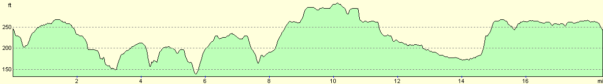
For more information on profiles, ascents and descents, see this page
Transport
I drove to and from Hargrave, which means that I did not rely on any public transport. I could also not find any bus service information boards in the village, so it could be that there are no bus services.
Disclaimer
Please note that I take no responsibility for anything that may happen when following these directions. If you intend to follow this route, then please use the relevant maps and check the route out before you go out. As always when walking, use common sense and you should be fine.
If you find any information on any of these routes that is inaccurate, or you wish to add anything, then please email me.
All images on this site are © of the author. Any reproduction, retransmissions, or republication of all or part of any document found on this site is expressly prohibited, unless the author has explicitly granted its prior written consent to so reproduce, retransmit, or republish the material. All other rights reserved.
Although this site includes links providing convenient direct access to other Internet sites, I do not endorse, approve, certify or make warranties or representations as to the accuracy of the information on these sites.
And finally, enjoy your walking!
Nearby walks
| # | Title | Walk length (miles) |
|---|---|---|
| 142 | Huntingdon Station to Hargrave | 17.3 |
| 213 | Rushden to Northampton | 16.4 |
| 219 | Rushden to Bedford | 15.4 |
|
|

|