Walk #183: Craven Arms to Church Stretton
 |
 |
|
General Data
| Date Walked | 10/03/2002 |
| County | Shropshire |
| Start Location | Craven Arms |
| End Location | Church Stretton Station |
| Start time | 10.00 |
| End time | 16.45 |
| Distance | 12.3 miles |
| Description | This was quite an exhilarating walk, made more so by the slightly extreme weather. The walk took in the Long Mynd, which is a justifiably famous tourist spot. |
| Pack | I carried full Pennine-Way kit for the first time in months. This included my tent, trangia, some food, and lots of spare clothes. |
| Condition | I was fairly fatigued at the end of this walk, the main problem being the underside of my feet which were aching. I have a couple of small blisters on a coupe of my small toes and my shoulders ache slightly, although they were not red like they were yesterday. Something I have to take note of is my back, which was slightly red by he time I finished the walk, which could be an early sign of a problem that has plagued previous walks. |
| Weather | The weather started off fairly nice, with some small areas of cloud in an otherwise blue sky and occasionally strong gusts of wind. As I started the climb up to the top of the Long Mynd it started to rain and the wind became stronger, making some periods of the long tramp along the ridge fairly uncomfortable. At times it was sleeting, although unlike yesterday there was no hail. The temperature was reasonable for the time of year, but this was not noticeable on the high ground due to the fierce wind. |
| OS map | Landranger number 137 (Ludlow & Church Stretton, Wenlock Edge) |
 |
 |
|
Map of the walk
Maps courtesy of Google Maps. Route for indicative purposes only, and may have been plotted after the walk. Please let me have comments on what you think of this new format. For a detailed table of timings for this walk, please see the table file.
Notes
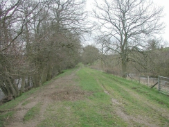
The first part of the walk was mixed, with a walk along an old railway line being followed by a laborious stretch of road walking to get to the southern end of the Long Mynd. The railway track was a permissive footpath called the Onny Trail, and as it was a permissive path it was not very well signposted. It was easy to follow, however, as the embankments and old cuttings were the only signposts that I needed. The only problems were in a couple of places where bridges had been removed, one of which meant a diversion quite a long way into a field to get over to the other side of the bridge.
The railway trackbed which the Onny Trail follows is part of the old Craven Arms to Bishop's Castle railway, which closed in 1935, despite the original railway company going bankrupt in 1866 and the line being run by a receiver with minimal expenditure being spent on it.
I had a rest at the start of the track up to the top of the Long Mynd, and this was enlivened by a stream of Lotus Elise's which came past along the road beside the track. There was a continuous stream of them of all colours, but I was bemused by an old banger that came past behind them which was going faster, probably due to not caring about the cattle grid which was beside where I was sitting.
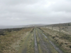
The weather was absolutely dire, and it made parts of the walk quite tiring. In particular the stretch of tarmac walking along the top of the Long Mynd was fairly exposed and very wet, with string gusts of wind blowing me about. Fortunately for the majority of the walk it was coming from behind and was hence giving me a welcome push along. Later on during the descent down to Church Stretton I passed Devil's Mouth and the full force of the wind hit me from the south, and I found it very hard to stay upright due to the sidewind.
At the start of the tarmac section on the top of the Long Mynd I came along a couple of walkers huddled by an information sign. They said that they had set off from Church Stretton and had intended to do a northeasterly route around the Long Mynd, but instead they had gone in the other direction. They complained that whenever they attempted to get their map out it was being ripped out of their hands, which was something that I could sympathise with, although I was in a better situation as my map was in a mapcase. They then followed me all the way to Pole Cott, where they turned to head southeastwards down towards Little Stretton.
The Long Mynd is absolutely lovely, but is spoilt by a fact that a road goes over the top of it. There is also a gliding club based at the top of it, and there are plenty of warning signs telling walkers not to stray from the path. The road had a fairly small but steady stream of cars coming along it. It was fairly hard to hear the cars that were coming from behind due to the noise of the wind, and it was not easy to follow the narrow grassy path next to the road due to the wind which could blow you from side to side, making it far easier to walk on the road.
The track that was followed along the top of the Long Mynd is called 'The Portway', and it is an ancient route. There are a few burial mounds along the route that are called Robin Hood Butts; I know that Sherwood Forest in Nottinghamshire is the place that most people associate with Robin Hood, and that other places in the area (such as Derbyshire and Staffordshire) also lay some claims on the mythical figure. But Shropshire?
In future I must ensure that I take waterproof trousers with me, as the last couple of days have been ideal times to wear them. I really do not like wearing them as I feel constricted by them, but in today they would have been worth the cost.
The batteries ran out in camera once again, meaning that I did not get many photos of the actual summit of the Long Mynd, but this was probably no bad thing due to the driving rain. There were some nice views available on the descent down into Church Stretton, with what must have been The Wrekin visible to the northeast. The wide expansive views that are apparently normally available were not to be found, however.
This little two-day trip has been fairly enjoyable despite the bad weather and some things (e.g. losing my pedometer yesterday) going badly. It has set me up well to progress westwards from Knighton into Wales and towards Aberwyswyth. One more weekend should see me getting to Llandrindod Wells, which will leave me with four days walking to get to the sea, which can hopefully be done over the extended easter weekend.
Directions
This walk starts off at a B&B on the A49(T), about a mile north of Craven Arms. The B&B is just before the left-hand turning leading to Cheney Longville. Leave the B&B (or walk there from Craven Arms along the A49(T)) and take the Cheney Longville road as it passes over a railway line. Immediately on the other, western, side of the railway bridge turn right into a grassy area which marks the start of the Onny Trail.
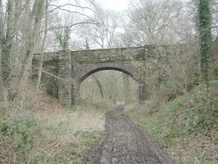
Follow the Onny Trail as it heads northwestwards along the southern bank of a river. The trail is easy to follow as it sticks to the embankments and cuttings of the old railway line. In a couple of places early on bridges have been removed, necessitating short detours down to the valley floor to get over the gap in the embankment. After a couple of kilometres an attractive overbridge is reached at Glenburrell, and shortly after this a footpath leaves the trackbed to the right and crosses the river by means of a footbridge before meeting the A489 road.
Turn left and follow the A489 road to the junction with the B4370 road. At the junction continue on along the A489 road as it heads in a roughly westerly direction past Hillend Farm and onto Plowden. At Plowden take a road that leads off to the right and follow it as it starts to climb uphill. Just before a cattle grid a track leads off to the right, signposted the Jack Mytton Way. Take this track as it steeply climbs up the southern end of the Long Mynd. The track is fairly obvious in places and is well signposted, but in one place care has to be taken as a track leads off to the half-right whilst the the Jack Mytton Way continues straight on.
The top of the Long Mynd is soon reached and the track becomes quite wide. It climbs and descends slightly until it meets a wooded area, which is skirted for a short distance. From here some white objects can be seen in the distance, and these are glider trailers belonging to the gliding club. The track leads on northwards past the gliding club until a surfaced road is reached.
Turn right and follow the road as it heads along the top of the Long Mynd. Pass the car park at Pole Cott and continue along the road as it turns to the northeast and then the east. After this it starts to descend gently to Cross Dyke, before the descent starts to get steeper Devil's Mouth and then down to Burway Hill. Some lovely views are available to the east and north during this descent despite the poor weather today.
The road down Burway Hill ends near the center of Church Stretton. Turn left and descend downhill to the B4370. Cross the B4370 and continue downhill along the B4371 road. Church Stretton railway station is a short distance to the right just before the A49(T) road is reached.
Distances
| From | To | Distance (m) | Ascent (ft) | Descent (ft) |
|---|---|---|---|---|
| Craven Arms B&B | Plowden | 4.3 | 505 | 397 |
| Plowden | Pole Cott | 4.8 | 1204 | 144 |
| Pole Cott | Church Stretton Station | 3.2 | 128 | 1093 |
This makes a total distance of 12.3 miles, with 1837 feet of ascent and 1634 feet of descent.
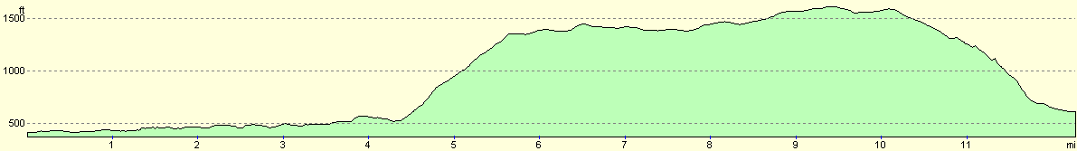
For more information on profiles, ascents and descents, see this page
Transport
There are regular train services between Church Stretton and Craven Arms, and some irregular bus services also serve the towns. In summer some bus services also run along the top of the Long Mynd.
Disclaimer
Please note that I take no responsibility for anything that may happen when following these directions. If you intend to follow this route, then please use the relevant maps and check the route out before you go out. As always when walking, use common sense and you should be fine.
If you find any information on any of these routes that is inaccurate, or you wish to add anything, then please email me.
All images on this site are © of the author. Any reproduction, retransmissions, or republication of all or part of any document found on this site is expressly prohibited, unless the author has explicitly granted its prior written consent to so reproduce, retransmit, or republish the material. All other rights reserved.
Although this site includes links providing convenient direct access to other Internet sites, I do not endorse, approve, certify or make warranties or representations as to the accuracy of the information on these sites.
And finally, enjoy your walking!
Nearby walks
| # | Title | Walk length (miles) |
|---|---|---|
| 178 | Broadstone to Church Stretton | 8.1 |
|
|

|