Walk #182: Knighton to Craven Arms
 |
 |
|
General Data
| Date Walked | 09/03/2002 |
| County | Powys, Shropshire |
| Start Location | Knighton |
| End Location | Craven Arms |
| Start time | 10.00 |
| End time | 16.45 |
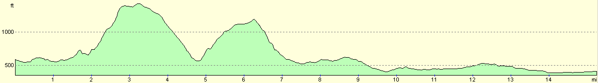
| Distance | 15.3 miles |
| Description | The first part of this walk was very nice, with lots of nice views available over the hills around Knighton. The second section comprised of lots of road walking. |
| Pack | I carried full Pennine-Way kit for the first time in months. This included my tent, trangia, some food, and lots of spare clothes. |
| Condition | I am fairly tired after this walk, which is not surprising as it was the first time that I had carried weight for a while. I have slight redness on my shoulders which is fairly usual, and my legs and feet feel relatively okay. |
| Weather | The main feature of today's weather as the wind, which was very strong and the region was battered by gale-force winds. These winds were accompanied by squally rain, hails and sleet. Later on in the day when I got off the hills the weather improved as the wind died down and the sun came out. |
| OS map | Landranger number 137 (Ludlow & Church Stretton, Wenlock Edge) |
 |
 |
|
Map of the walk
Maps courtesy of Google Maps. Route for indicative purposes only, and may have been plotted after the walk. Please let me have comments on what you think of this new format. For a detailed table of timings for this walk, please see the table file.
 |
 |
|
Notes
Today was spoilt by the weather, which was very bad when I was on the hills, with a wind being followed up with periods of rain. Despite this it was still a fairly enjoyable walk, but nearly as much as it would have been without the weather.
I got depressed during this walk, as I realised that my brand-new pedometer had fallen off my belt. I had not looked at it for over half an hour, so I did not fancy climbing the hill to go back and find it.
I also had problems with my map case, which I have only used for two other trips. This started leaking, and it has caused my map to get wet and rip. This is doubly annoying as my previous mapcase by the same manufacturer lasted for nearly two years.
When I got to Broome where I had intended to camp I found that the pub was shut, and with the weather being what it was I did not fancy camping out. I therefore decided to walk on to Craven Arms. The route that I took into Craven Arms passed a large hotel, and since they are generally more expensive than I like I enquired about if there were any b&B's in the area. The assistant in a florist told me that there was one by the station. I went there and found no-one in, so I went back into town. I then asked in a newsagent and he got out a brochure which he gave me and phoned up for me. The B&B was about three-quarters of a mile north of the station, and is very nice.
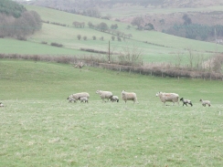
Many of the fields were full of newborn lambs, and it was lovely to see them running about in the fields, and was a nice sign that spring was here, even if the weather did not seem to know it. It also reminded me of how many animals had been killed during the foot and mouth outbreak during the previous year, a sobering thought, but at least the lambs were a sign of recovery in the countryside.
There was a castle marked on the map in the village of Hopton, a few hundred yards off the route I was planning to take. I made a little diversion to get a better view of it. What remains is a small but impressive structure, with the keep/tower house still being extant on the earthworks. The castle was destroyed after a three-week siege in 1644 during the civil war, when the castle was garrisoned by parliamentary forces.
About the only good feature about today's weather was two rainbows that were visible later on in the day as the clouds started to part. The sight of these cheered me up, and helped me move on.
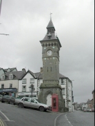
I had spent the previous night in a B&B in Church Stretton, so I caught an early train to Knighton. When I got to Knighton I needed to purchase some batteries, so I walked into the town centre, and hence into Wales as the town is perched on the England/Wales border. Knighton was a quite nice little town, and was obviously very country-focussed, with several farm machinery sales firms and agricultural feed places on the way from the station into the town centre. It was quite a nice little town, with some nice buildings scattered about, including a 19th century clock tower. In Welsh the town is known as Tref-y-Clawdd, which translates as 'the town on the dyke', which refers to Offa's Dyke, an ancient earthwork that runs through the area. The town is on two long distance footpaths; the Offa's Dyke Path, which is a National Trail that runs all the way from Chepstow to Prestatyn, roughly following the Wales/England border. The other is the Glyndwys Way, which is a circular walk between Knighton, Machynlleth and Welshpool.
The B&B that I stayed in was about a mile north of Craven Arms, and after I had had a bath I did not feel like going out for an evening meal. I was fairly tired, so I decided to go to bed early rather than walk back into town for a meal. I was rather concerned that this would leave me hungry the next day, but when I woke up I found that I was not that hungry and the breakfast provided by the landlady was most sufficient.
Something really freaky happened last night. At just before three thirty in the morning I woke up, and in the darkened room I saw something - I am unsure what - moving from the door to the side of my bed. My first thought was that someone was sleep walking, so I said 'hello?' twice, but with no reply. The window to the left-hand side of my bed was letting a very hazy light in, and I could see this figure come to the head of my bed and lean over me, although in the darkness I could not see any features. I reached out to my bedside light, but in the few seconds it took me to find the switch the figure had gone.
This slightly freaked me out. As the figure had moved towards the bed it had passed in front of a wall-mounted TV which had a red standby light glowing. As it passed in front of the TV the red standby light blinked out, which is another piece of evidence that something was in the room. I also had a distinct feeling that the figure was male, although I have no idea how I could reach such a conclusion.
So what could it have been? There is always the possibility that I imagined the whole thing, but I have little doubt that I was wide awake when it occurred. I doubt that it could have been a sleepwalker, as the door did not open in the time it took me to switch on the light, and there was no-one in my room at the end.
This morning I mentioned this event to the landlady to see if she knew of any previous occurrences, but she had not heard of anything. I am slightly amused by this whole event, and I am quite glad that it happened as I have found the whole matter quite intriguing.
I really want to do the Long Mynd tomorrow, but the weather forecast is very bad and it may be wiser to take a lowland route instead. I will make a decision when I wake up and see how I feel and what the weather is doing. There are several alternative routes that I could take, but all are shorter than the route over the Long Mynd.
Directions
This walk starts off at the clock tower in the center of Knighton. Head downhill along the High Street and take the A488 Station Road that leads off to the left, opposite a white building. Follow the road as it heads through the town and crosses the River Teme before reaching the station. Cross the bridge over the railway line and follow the A488 road as it turns sharply to the right.
Shortly after the bend a footpath leads off to the left up a hillside, following a track. Take this footpath as it ascends through a wooded area above the A488 road. After about half a mile the track emerges from the treeline at a more substantial track which ascends the hillside in a series of zigzags from the A488 road. Descend down one of the zigzags and take a footpath that continues across a field to meet the A488 road. In the middle of the field is a small stream which can be crossed using a bridge.
Cross the A488 road and take a footpath that starts on the opposite side. Follow this footpath as it heads in a south-northeasterly direction beside a hedge. The footpath then goes through a gate onto the other side of the hedge, which it follows until a track is met above Stowe. Cross the track and take a footpath that leads the short distance down the hill to a surfaced road at Stowe.
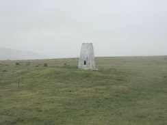
Turn left along the road and then almost immediately right, to head uphill along a footpath. After a short distance this footpath meets a track. Follow the track as it heads northeastwards up the hill to Holloway Rocks. At the end of the track a footpath continues on in the same direction past the rocks until it meets a bridleway which runs west to east just off the top of Stowe Hill. A few hundred yards southeast of the point where the footpath meets the bridleway is the Trig Point on Stow Hill, which is worth a visit.
Continue eastwards along the bridleway until it meets a track at the edge of Bucknell Wood at 3220 7495. Here the bridleway descends down the hill to the northeast to a ruined farm at Vron. It then skirts the northern part of Bucknell Wood before crossing the River Redlake and meeting a road.
Turn right along the road and then almost immediately take a track that leads uphill to the left. This track heads northeastwards, squeezing between a farm and the hedge before turning northwards for a short distance. It then turns northeastwards once more and passes a farm before ascending a hill . The track ends and the footpath continues on until it ends at a junction with a road and several tracks.
At the junction turn left to head north on the short climb up to Meeroak Farm. Continue straight on for about a hundred yards past the farm until a hedge is met. At the hedge turn right and follow a green track that heads northeastwards into the woodland at Hopton Titterhill. When track is met continue straight on along another, smaller, track that starts to descend down the northern side of the hill. When this descent ends at another track turn right along his track and then left down another one that turns back on itself before heading northeastwards across fields to a road in Hopton.
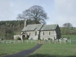
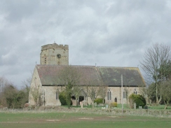
The rest of this walk is now road walking. In Hopton turn right and pass the church. Cross over a stream and follow the road through the village. Take the first road to the left, but before this it may be worth continuing on for a short distance to the east to get a better view of the remains of Hopton Castle. If you do not want to see the castle, the road to the left leads northeastwards for about a kilometre until it ends at the B4385 road at Three Ashes. Turn left along the B4385 and take the first road to the right, which heads eastwards for about a mile before passing under a railway line and enters the little village of Abcott.
The road ends at a junction with the B4367 road in the village. Continue on to the east and cross over the River Clun and climb up the hill to a T-junction in Clungunford. At the junction turn left to head north for a couple of kilometres until Broome is reached. Broome railway station is a short distance to the left down the B4369. The B4367 continues on to the northeast before passing under the railway line, and about two kilometres further on it ends at a T-junction in Long Meadowend.
In Long Meadowned turn right and follow the B4368 as it heads northeastwards and later eastwards alongside the railway line into Craven Arms.
The B&B that I stayed in was about a mile north of the town along the A49(T), just before the turning to Cheney Longville. There is a footpath all the way from Craven Arms to the B&B.
Distances
| From | To | Distance (m) | Ascent (ft) | Descent (ft) |
|---|---|---|---|---|
| Knighton | Hopton Castle | 7.6 | 1706 | 1772 |
| Hopton Castle | Broome | 4.1 | 276 | 344 |
| Broome | Craven Arms B&B | 3.6 | 125 | 167 |
This makes a total distance of 15.3 miles, with 2107 feet of ascent and 2283 feet of descent.
For more information on profiles, ascents and descents, see this page
Accommodation
I stayed at the Groveside Country House Bed & breakfast, at Groveside, Shrewsbury Road, Craven Arms, Shropshire, SY7 8BX, Tel: (01588) 672948. This was a very nice bed and breakfast with a very nice proprietor who made me feel very welcome. The room was nice and comfortable and the breakfast was delicious.
Disclaimer
Please note that I take no responsibility for anything that may happen when following these directions. If you intend to follow this route, then please use the relevant maps and check the route out before you go out. As always when walking, use common sense and you should be fine.
If you find any information on any of these routes that is inaccurate, or you wish to add anything, then please email me.
All images on this site are © of the author. Any reproduction, retransmissions, or republication of all or part of any document found on this site is expressly prohibited, unless the author has explicitly granted its prior written consent to so reproduce, retransmit, or republish the material. All other rights reserved.
Although this site includes links providing convenient direct access to other Internet sites, I do not endorse, approve, certify or make warranties or representations as to the accuracy of the information on these sites.
And finally, enjoy your walking!
Nearby walks
| # | Title | Walk length (miles) |
|---|---|---|
| 178 | Broadstone to Church Stretton | 8.1 |
| 183 | Craven Arms to Church Stretton | 12.3 |
| 689 | Glyndwr's Way: Knighton to Beacon Lodge | 10.8 |
|
|

|