Walk #181: Boston to Fosdyke Bridge
General Data
| Date Walked | 25/02/2002 |
| County | Lincolnshire |
| Start Location | Boston Station |
| End Location | Fosdyke Bridge |
| Start time | 09.42 |
| End time | 13.34 |
| Distance | 11.6 miles |
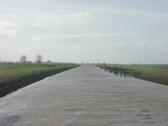
| Description | This was what should have been a nice and easy walk along seawalls beside two river estuaries. Unfortunately it was spoilt by the fierce wind which made the walk far more difficult and less enjoyable than it should have been. |
| Pack | >I carried my 30-litre rucksack with a bag of extra clothing and a water bottle inside it. |
| Condition | I am relatively okay after this walk, with no new blisters to trouble me. I am however, fairly tired as walking in the string wind was fairly difficult. I am also slightly chilled as the wind just cut through the four layers that I was wearing. |
| Weather | The main feature of the weather during the walk was the wind, which was blowing very strongly from the southwest. This meant that it was blowing from near head-on for large portions of the walk. Fortunately there was only about a minute of snow during the whole walk, so I was not wet for the journey. The overall temperature was fairly low, probably only about five degrees, and this combined with the wind made the walk fairly uncomfortable. |
| OS map | Landranger number 131 (Boston & Spalding) |
 |
 |
|
Map of the walk
Maps courtesy of Google Maps. Route for indicative purposes only, and may have been plotted after the walk. Please let me have comments on what you think of this new format. For a detailed table of timings for this walk, please see the table file.
 |
 |
|
 |
Notes
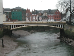
The first part of the walk was dominated by the Boston Stump, the tower of St Botolphs church. At 272 feet high it is the tallest parish church tower in England (although see this site for why this is a bit of a misnomer) and it dominates the whole of the surrounding area. The church was started in 1309 and completed (without the tower) in 1390. The tower was started in 1425 and work was completed sometime around 1520. Unfortunately I cannot say that I found it very pleasing to the eye; the tower looks rather 'busy' and messy, although I did only see it from one side, and pictures I have seen from other angles look less cluttered.
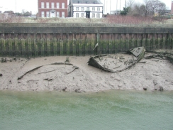
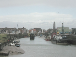
The port at Boston is alongside the river, and it looked fairly busy. On the way there were the remains of several sunken wooden boats embedded firmly into the mud - the skeletal remains were quite fascinating, especially as a couple of them were still tied up to the quayside! Whether anyone expected them to get out of the mud and float away I do not know, but it strikes me as being nigh on impossible due to the state that they were in. There were a couple of big boats in the port, and it made me wonder what gets shipped to and from the port; grain perhaps? A little research on the Internet shows that 1,500,000 tons of cargo are handled per year, comprising mainly of steel, paper and timber, and not the grain that I had expected.
A sad aside to the port was the condition of the railway line which feeds the port; this crosses the river by the means of a fascinating swing bridge which I passed early on in the walk, although unfortunately the condition of the tracks led me to think that no trains had been along it in a while.
As I was walking along the Macmillan Way along the southern bank of the river to the south of Boston a great swarm of white birds became visible. As I got nearer them I discovered (mainly be means of my nose) that I was approaching a large tip which was right beside the river. What followed was a very smelly ten minutes as the path skirted between the pit and the river and the strong wind blew the odours towards me. The ground in this area was also fairly disgusting, leading me to wonder whether the pit had at one time been nearer to the river and had slowly moved away.
The main feature of the walk was the very fierce wind, which was the strongest that I had walked in in some time. Unfortunately the wind was coming from the southwest, which meant that for the majority of the walk it was blowing straight towards me and hindered my progress considerably. This was made worse by a brief snow flurry that made me look out for more to some and dampened my mood if not my body.
As I was nearing Fosdyke Bridge Sam phoned me up on my mobile and asked me if I wanted to be picked up. She told me that it was snowing very heavily in Peterborough, and since it had taken me far longer then I had expected to do the walk so far I reluctantly agreed. I was due to go for another couple of dives the next day, and I did not want to get myself too tired before that, which was another factor that I had to take into consideration. I could probably have reached Spalding before it got dark, but at the rate that I was going it would have been very tight and would have been very tiring. This means that I have got another ten or eleven miles to do another day to get from Fosdyke Bridge to Spalding, which is annoying but will have to be done sometime soon.
Shortly after she phoned I met a man who was walking in the opposite direction along the top of the banking with a dog. He was walking with the wind and was getting blown along at a fair old rate, and he said to me that on the way back he would walk along the bottom of the bank as I was to avoid the wind. As I watched him go into the distance I wished that I had been walking in that direction as it certainly seemed much easier than going the way I was!
When Sam arrived we had a drink in the pub at Fosdyke Bridge before getting into the car for the drive back to Cambridge. I had been wearing a cheap pair of plastic waterproof overtrousers over my walking trousers (mainly to keep the wind away), and when I pulled these off I found that my legs were soaking wet from sweat. The top half of my body (protected by a breathable Lowe Alpine Foraker coat) was dry, which just shows how useful breathable materials can be. I will have to buy another pair of breathable overtrousers before I go to Scotland for my main walk - my old pair are ripped.
Directions
This walks starts at the railway station in Boston. From the car park in Boston take Lincoln Lane that heads eastwards towards a supermarket and the River Witham. At a bridge over the river near the imposing spire of St Botolphs Church, turn right and head along the High Street as it follows the western bank of the rover through the town. The path soon meets a road, which can be followed southwards until the A16(T) is reached in the centre of the town.
Cross straight over the A16(T) and continue southwards down the High Street. The river is left behind for a short distance until it is regained again, the road becoming London Road in the process. Shortly after this a railway level crossing is reached, with a swing bridge in the middle of the river beside it. A short distance after this a bridge carries the road over the South Forty Foot Drain where it meets the River Witham. Cross this bridge to get to the southern side of the Drain.
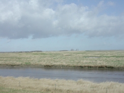
From here the Macmillan Way can be followed to the end of the walk. On the southern side of the bridge turn left and climb up to some grassy banking that leads eastwards along the southern edge of the River. After about half a mile it passes under two sets of powerlines before swinging to head southeastwards. It continues in this direction for four and a half kilometres until the Haven is reached.
At TF 365 392 some care has to be taken as two paths diverge along the top of two banks; a dead-end one heads eastwards towards the sea whilst the Macmillan Way continues on to the southeastwards. A short distance after this junction the path turns ninety degrees to head southwestwards towards Frampton Marsh.
The way is very easy to follow from here as it remains on the top of the flood banking as it winds its way southwestwards. A final zig-zag brings the flood banking to the northern side of the River Welland. It passes under some power lines and about a mile later it meets the bridge that carries the A17(T) main road over the river. The pub is just on the other side of the bridge.
Distances
| From | To | Distance (m) | Ascent (ft) | Descent (ft) |
|---|---|---|---|---|
| Boston Station | End of The Haven | 5.2 | 69 | 66 |
| The Haven | Fosdyke Bridge | 6.4 | 20 | 23 |
This makes a total distance of 11.6 miles, with 89 feet of ascent and 89 feet of descent.
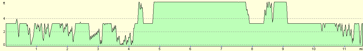
For more information on profiles, ascents and descents, see this page
Transport
There are some bus services that run between Spalding and King's Lynn, calling at Fosdyke Bridge, Long Sutton and Sutton Bridge in the process. There are also railway stations in Spalding and Boton, although no direct train services run between the two and you have to change at Sleaford. There are also mbus services between the two towns which run directly with no need to change.
Disclaimer
Please note that I take no responsibility for anything that may happen when following these directions. If you intend to follow this route, then please use the relevant maps and check the route out before you go out. As always when walking, use common sense and you should be fine.
If you find any information on any of these routes that is inaccurate, or you wish to add anything, then please email me.
All images on this site are © of the author. Any reproduction, retransmissions, or republication of all or part of any document found on this site is expressly prohibited, unless the author has explicitly granted its prior written consent to so reproduce, retransmit, or republish the material. All other rights reserved.
Although this site includes links providing convenient direct access to other Internet sites, I do not endorse, approve, certify or make warranties or representations as to the accuracy of the information on these sites.
And finally, enjoy your walking!
Nearby walks
| # | Title | Walk length (miles) |
|---|---|---|
| 249 | Gibraltar Point to Boston | 24.7 |
| 250 | Boston Station to Holbeach St Matthew | 20.7 |
| 251 | Holbeach St Matthew to Sutton Bridge east bank car park | 15.7 |
|
|

|