Walk #251: Holbeach St Matthew to Sutton Bridge east bank car park
 |
 |
|
General Data
| Date Walked | 30/10/2002 |
| County | Lincolnshire |
| Start Location | Holbeach St Matthew |
| End Location | Sutton Bridge east car park |
| Start time | 07.40 |
| End time | 14.05 |
| Distance | 15.7 miles |
| Description | This was a short walk following the coast around from Holbeach St Matthew to the mouth of the River Nene, followed by a walk down the western bank of the Nene to Sutton Bridge. A walk along the eastern bank followed this back to the mouth of the river. |
| Pack | Today I carried my 30-litre Karrimor HotRock rucksack, which was filled with my packed lunch, waterproof leggings, water bottle and a couple of spare shirts, together with the usual assortment of odds and ends. |
| Condition | I have had absolutely no problems after this walk, which is to be expected after such a relatively short walk. |
| Weather | The weather today was one of sunshine and cloud with a little wind. There was no sign of any rain whilst I was walking, but there was some once I had stopped and was back at the campsite with Sam. |
| OS map | Landranger number 131 (Boston & Spalding) |
 |
 |
|
 |
Map of the walk
Maps courtesy of Google Maps. Route for indicative purposes only, and may have been plotted after the walk. Please let me have comments on what you think of this new format. For a detailed table of timings for this walk, please see the table file.
Notes
When Sam dropped me off at the place I had finished the last walk, on a road just to the northwest of Holbeach St Matthew, I could see that the red warning flags were flying on the range. This left me in a slight quandary; should I risk walking along the bank past the flags or should I make a diversion inland. After a little thought I decided to do the latter, but when I reached Sutton Bridge and went into the pub there I found out that the public are allowed to walk along he bank even when the flags are flying. I find this slightly annoying, as the rules appear to vary from range to range and there seems to be no way of finding out in advance where you can walk and where you cannot. There is a road running along the top of the bank, which also means that I could have made fast progress.
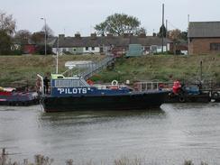
When I was walking down the path towards Sutton Bridge, the cranes of Port Sutton bridge became visible. The path passes right through this port, and the whole area was a hive of activity. The port was opened in the 1980's after having been shut for many years, and is now very busy. Whilst I was there I saw ships registered in many places, including London and Amsterdam.
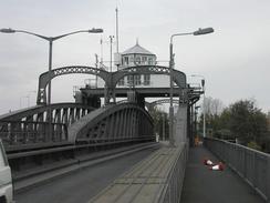
The bridge in Sutton Bridge is a lovely swing bridge, It was constructed in 1897 by the Midland and Great Northern railway to allow road and rail traffic over the bridge, and was the third bridge at or near this location since the first one was built by Sir John Rennie in 1830. The bridge is hydraulically operated, and opens to allow ships to go up the river to Wisbech. The bridge used to open about 900 times a year, but the opening of Port Sutton Bridge has caused the importance of the port at Wisbech to decline, and now it only opens a few times a week.
I stopped off in Sutton Bridge at the New Inn, which was a lovely little pub where I had a couple of pints to celebrate reaching my five hundredth mile yesterday. The bar is very unusual in that the face of it is lined with a whole series of cast iron fire grates that give it a very curious yet attractive look. I chatted to the locals in the pub for about an hour whilst I drunk the beer, and one of them was from Nottinghamshire and knew some my old haunts, so we reminisced about them.
I was last at Sutton Bridge a couple of years ago, when a national emergency was declared because a ship had sunk in the river. Between the bridge and the port there is a winding hole (a place where boats can turn around), where large ships could tie up their bows against the bank and let the current drag their stern downstream and thus turning them around. Whilst doing this one day a ship got caught on the riverbank, and as the tide went out it broke it's back, thus blocking the entire river. When the tide went out once again it broke in half again, leaving the ship in three parts on the riverbed. The cargo had to be unloaded by crane using divers, and then a chain was used to saw the ship into three parts (although it had broken into three parts much of the hull plating was still attached). Then all three parts of the ship had to be lifted out of the river. A Norwegian firm did all this, and I had been in Kings Lynn with Sam one day when we decided to make a diversion to see this. When we arrived we saw the ship lying in the river in three parts, and a flurry of activity as cranes were offloading the cargo. It was a memorable sight, and I still have the pictures of the ship lying broken in the river.
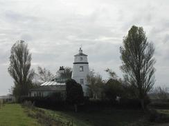
Near the mouth of the Nene there are two attractive lighthouses that are now disused for their original purpose and have been converted to houses. The one on the eastern bank is famous as it is where Peter Scott lived between 1933 and 1939, paying an annual rent of five pounds a year. He kept wild geese here and painted many of his pictures of wildfowl, and a walk up the eastern bank of the river has been named after him.
It felt quite strange to be walking along the Nene Way on the last part of this walk. This is a long distance footpath that I have walked many parts of, but have never actually done the whole thing. I am tempted to say that one day I shall set out to walk the whole thing, but that would have to be after this trip, and that seems so far away that making any commitments seems unthinkable.
This evening Sam and I decided that we wanted a drink, and so we went into the Bull Inn in the village. Whilst we were there we chatted to the locals, and when a couple of businessmen left they gave us twenty pounds for the charity. Yet again on this walk I have seen kindness, and yet again it is hard to find words to express gratitude.
Directions
This walk starts off at a road just to the northwest of Holbeach St Matthew, at TF 40819 32867. There are two choices you can make here; you can either walk northwards along this road to the sea bank that goes through the RAF bombing range, or you can follow the inland route that I describe here if the red flags are flying on the range.
Follow the road down to a road junction beside a red telephone box. At the junction continue straight on and follow the road as it curves around past the little church and Acre Farm before settling on a south-westwards course. Take the first road to the left which heads past a place called Sot's Hole. Continue along this road for a little over a kilometre and then take the first road to the left, which leads up towards Wards Farm.
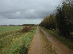
Walk through Wards Farm and continue on as the road ends and becomes an unsurfaced track. Just before an area of low trees is reached on the right turn right along another track, which goes over a drain on a bridge. Keep on this track as it heads eastwards, varying in quality from a green lane to a wide, broad track, as it passes Browns Farm and then curves to the right.
Shortly after the bend a track comes in from the left. Continue past this for a few yards and then turn left onto the top of a bank. Walk along this bank for around twenty yards and then turn left down the edge of a field towards the sea bank which is in the distance ahead. At the end of the field turn left along another track for about a hundred yards and then turn right down a public road.
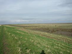
Follow this road as it heads south-eastwards, passing to the north of the village of Gedney Drove End. When the road meets a trig point and turns to the right, turn left down a track that heads north-eastwards for a short distance to the sea bank. At the sea bank turn right and follow it as it curves around for a couple of miles, passing over the sluice for Lutton Leam before finally heading southwards to meet a lighthouse on the western bank of the river Nene.
Follow the path past the lighthouse and onto a road. Continue south along this road until it turns to the right and then continue straight on down a byway that heads along the banks of the river. After a couple of kilometres the path enters Port Sutton bridge, where care has to be taken whilst walking south along the road past all the cranes and lorries.
Continue on through the port and follow it as it curves around a winding hole in the bank of the river. The road approaches a bridge over the river and then curves to the right. At the bend take a path that leads off to the left and join the A17(T) road just beyond a roundabout.
Cross the river Nene using the bridge, and once on the other side turn left to walk down a road that runs northwards along the eastern bank of the river. Continue along this road for three miles until you reach the east bank car park, which is on the right just before a lighthouse is reached.
Distances
| From | To | Distance (m) | Ascent (ft) | Descent (ft) |
|---|---|---|---|---|
| Holbeach St Matthew | Western Sutton Bridge lighthouse | 9.4 | 3 | 13 |
| Western Sutton Bridge lighthouse | Sutton Bridge | 3.1 | 23 | 20 |
| Sutton Bridge | East Bank car park | 3.2 | 7 | 7 |
This makes a total distance of 15.7 miles, with 33 feet of ascent and 40 feet of descent.
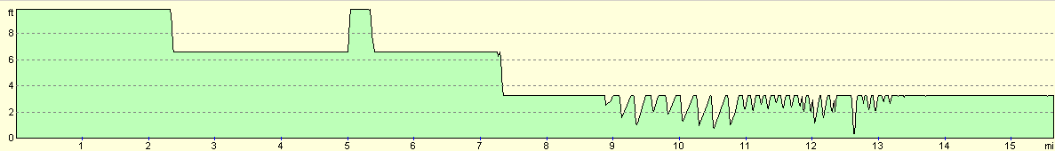
For more information on profiles, ascents and descents, see this page
Accommodation
We stayed at Delph Bank Touring Caravan and Camping Park, Old Main Road, Fleet Hargate, Holbeach, Spalding, Lincolnshire, PE12 8LL. They can be contacted on 01406 422910 and they have a website at www.ukparks.co.uk/delphbank. This was a lovely little site that was well maintained and clean. It cost us ten pounds for the night, including electricity hook-up.
Please note that I take no responsibility for anything that may happen when following these directions. If you intend to follow this route, then please use the relevant maps and check the route out before you go out. As always when walking, use common sense and you should be fine.
If you find any information on any of these routes that is inaccurate, or you wish to add anything, then please email me.
All images on this site are © of the author. Any reproduction, retransmissions, or republication of all or part of any document found on this site is expressly prohibited, unless the author has explicitly granted its prior written consent to so reproduce, retransmit, or republish the material. All other rights reserved.
Although this site includes links providing convenient direct access to other Internet sites, I do not endorse, approve, certify or make warranties or representations as to the accuracy of the information on these sites.
And finally, enjoy your walking!
This walk was mentioned in the following routes:
Disclaimer
| My walk around the coastline of Britain |
Nearby walks
| # | Title | Walk length (miles) |
|---|---|---|
| 181 | Boston to Fosdyke Bridge | 11.6 |
| 249 | Gibraltar Point to Boston | 24.7 |
| 250 | Boston Station to Holbeach St Matthew | 20.7 |
|
|

|