Walk #252: Sutton Bridge east bank car park to Kings Lynn
 |
 |
|
General Data
| Date Walked | 31/10/2002 |
| County | Lincolnshire, Norfolk |
| Start Location | Sutton Bridge east car park |
| End Location | Kings Lynn TI |
| Start time | 10.10 |
| End time | 14.58 |
| Distance | 13.2 miles |
| Description | This was a lovely short walk following the banks of the Wash and the River Ouse into Kings Lynn. |
| Pack | Today I carried my 30-litre Karrimor HotRock rucksack, which was filled with my packed lunch, waterproof leggings, water bottle and a couple of spare shirts, together with the usual assortment of odds and ends. |
| Condition | I feel absolutely fine after this walk, and had no trouble at all with anything. I did not get a blister today, which means that my blister count for the month's walking so far is one. |
| Weather | The weather today was beautiful; for most of the day there was either sunny skies or at the most thin, hazy cloud. There was very little wind to bother me, and the weather made walking a joy. |
| OS map | Landranger number 131 (Boston & Spalding) and Landranger number 132 (North West Norfolk, King's Lynn & Fakenham) |
 |
 |
|
 |
 |
|
Map of the walk
Maps courtesy of Google Maps. Route for indicative purposes only, and may have been plotted after the walk. Please let me have comments on what you think of this new format. For a detailed table of timings for this walk, please see the table file.
 |
Notes
This was a short walk but an enjoyable one nonetheless, particularly in today's lovely weather. I would not have minded in extending this walk slightly, but there was nowhere obvious that Sam could pick me up until I got to near Shepherd's Port as there is no public road access to the sea bank. This is a shame, as another five miles would have seen me completing ten percent of the walk in a month, but I have got so near to that particular target that I am not devastated by missing it.
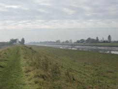
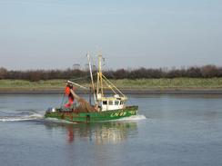
Whilst I was walking downstream along the banks of the Great Ouse, I saw many trawlers coming past up and down stream. There was also a large cargo ship that overtook me as I was nearing the overhead power cables over the river, and when I was opposite the docks in Kings Lynn I could see it enter a dock. It is nice to see a port that is so busy despite all the reduction in fishing quotas that have bee introduced over the past few years.
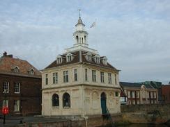
Kings Lynn is a town I know quite well, and I absolutely love it. There are some lovely buildings in it, and it is still mostly unspoilt. In particular I like the area round the Tuesday market square - it has some lovely buildings arranged around it and fortunately they have not been spoilt by having their ground floor windows knocked through to form large shop windows. This is something that I have come to hate in many towns and cities - the way some lovely buildings are emasculated by shop owners.
After Sam picked me up we went back to the van, which was parked in the Tuesday market square which becomes a car park for the rest of the week. I had not read any emails for over a week, so I went to the local library and spent half an hour catching up with what is happening with some of my friends and reading new stories. The library in Kings Lynn is in a beautiful building - the sort of building that most libraries in Britain moved out of in the sixties and seventies to be replaced with ugly concrete monstrosities. It is nice to see a library building still being used for its original purpose.
I have now been walking for an entire month, and I am very surprised by exactly how good I am feeling. I have had no major blisters, I have not had to shorten any walk due to injury, and I am feeling far fitter than I did before I started. I can only hope that this situation continues on for the rest of the walk.
Directions
This walk starts off at the east ban car park, just to the south of the lighthouse on the eastern bank of the river Nene to the north of Sutton Bridge. Leave the car park and turn right to head north for a short distance to the lighthouse, where the road turns to the right. At this point turn left and enter a field and skirt the left-hand edge of the lighthouse grounds.
Once past the lighthouse climb back up onto the top of the sea bank and follow it as it heads northwards. After about a kilometre it turns sharply to the right to head in an easterly direction. Continue along the bank as it skirts the edge of some marshland for a few miles. After about two miles the border with Norfolk is reached and another completed county can be ticked off my list.
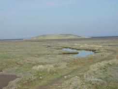
The bank twists and turns whilst maintaining a rough easterly direction, passing a little car park, which is unmarked on the map, on the fens to the right. This car park is connected by a track to the smaller of the two islands on the Breast Sands.
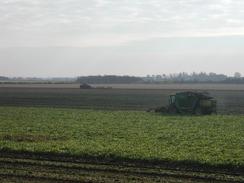
Pass the car park and continue on after a while the sea bank starts to curve to a more south easterly direction, passing a farm shed on the right and reaching Admiralty Point as it starts to meet the mouth of the River Great Ouse. Continue on south-eastwards until the bank meets another bank at a T-junction. At this junction turn left and follow the bank as it heads in a more southerly direction along a footpath. The path passes through a short patch of hedgerow, which forms an arch overhead, and then passes into a long field with a hedge between the path and the river to the left.
Pass under some power lines and continue on until the path ends at a fence across the top of the bank in West Lynn. At this point drop down to the right onto an unsurfaced road and follow this around as it curves to the right. When it meets a surfaced road after a short distance turn right up Ferry Square until it ends at a T-junction with a more major road.
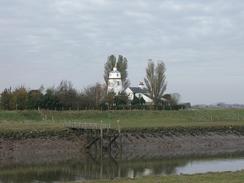
Turn left along this road and follow it as it heads southwards through West Lynn. When the church is reached take a path that leads off to the left and passes to the left of a children's play area and a bowls court. This path soon ends at the sea bank once more. At the bank turn right and follow a footpath along the top of it southwards to a bridge over the river.
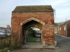
Turn left and cross the bridge. Once on the other side turn left and walk north-eastwards along the grass bank. The path soon becomes a surfaced cycle path that allows quick progress. The path ends at a sluice over the River Nar outfall. Cross the sluice and then turn left to follow a couple of roads past a lovely brick gatehouse that is stuck incongruously at the edge of a car park. Just before a mini roundabout is reached turn left and walk past another car park towards Bouls Quay.
When the river is met turn right and walk along South Quay, avoiding all the lorries loading stores onto ships. Continue on along this very attractive road until the road starts to curve to the right, and the Tourist information office is ahead on the left at the end of a small inlet.
Distances
| From | To | Distance (m) | Ascent (ft) | Descent (ft) |
|---|---|---|---|---|
| Sutton Bridge East Bank car park | Admiralty Point | 6.9 | 3 | 3 |
| Admiralty Point | Kings Lynn TI | 6.3 | 52 | 48 |
This makes a total distance of 13.2 miles, with 55 feet of ascent and 51 feet of descent.
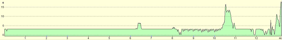
For more information on profiles, ascents and descents, see this page
Accommodation
We stayed at the lovely camping and caravanning club site at Sandringham, a few miles to the north of Kings Lynn. The site can be contacted at: The Camping and Caravanning Club Site, The Sandringham Estate, Double Lodges, Sandringham, Norfolk, PE35 6EA, or by telephone at 01485 542555. This was a lovely little site in perhaps the best setting we have stayed in so far on this trip - right in a clearing in the trees in the heart of the Sandringham Estate. It is a lovely location, and cost us twelve pounds fifty pence for the night.
Disclaimer
Please note that I take no responsibility for anything that may happen when following these directions. If you intend to follow this route, then please use the relevant maps and check the route out before you go out. As always when walking, use common sense and you should be fine.
If you find any information on any of these routes that is inaccurate, or you wish to add anything, then please email me.
All images on this site are © of the author. Any reproduction, retransmissions, or republication of all or part of any document found on this site is expressly prohibited, unless the author has explicitly granted its prior written consent to so reproduce, retransmit, or republish the material. All other rights reserved.
Although this site includes links providing convenient direct access to other Internet sites, I do not endorse, approve, certify or make warranties or representations as to the accuracy of the information on these sites.
And finally, enjoy your walking!
This walk was mentioned in the following routes:
| My walk around the coastline of Britain |
Nearby walks
| # | Title | Walk length (miles) |
|---|---|---|
| 4 | Downham Market to Watlington | 6.2 |
| 28 | Kings Lynn to Watlington | 7.4 |
| 156 | Kings Lynn to Snettisham | 14.6 |
|
|

|