Walk #253: Kings Lynn to Hunstanton
 |
 |
|
General Data
| Date Walked | 01/11/2002 |
| County | Norfolk |
| Start Location | Kings Lynn TI |
| End Location | Hunstanton sealife centre |
| Start time | 08.18 |
| End time | 13.50 |
| Distance | 16.0 miles |
| Description | This was a pleasant amble north from Kings Lynn to Hunstanton. It was slightly spoilt but the fact that I could not walk along the seawall for the first part of the walk. |
| Pack | Today I carried my 30-litfre Karrimor HotRock rucksack, which was filled with my packed lunch, waterproof leggings, water bottle and a couple of spare shirts, together with the usual assortment of odds and ends. |
| Condition | I feel absolutely fine after this walk, and could easily have walked further if the need had arisen. I still have no blisters and I did not have any aches or pains all day. |
| Weather | The weather today was quite good, with some blue sky visible for most of the day. It did attempt to drizzle for about five minutes in the late morning, but this soon died away. There was not much wind to spoil the day, and it was quite warm for the time of year. |
| OS map | Landranger number 132 (North West Norfolk, King's Lynn & Fakenham) |
 |
 |
|
 |
 |
|
Map of the walk
Maps courtesy of Google Maps. Route for indicative purposes only, and may have been plotted after the walk. Please let me have comments on what you think of this new format. For a detailed table of timings for this walk, please see the table file.
Notes
The first thing to note about today's walk is that the majority of it was along farm tracks that are not necessarily public rights of way, so I cannot say for sure that this walk does not involve trespass. I am on tracks at all times, however, and am not cutting cross-country so I feel that it is not too bad. I was also passed by a plethora of vehicles that did not bat an eyelid at my presence.
My initial plan was to go out and investigate following the banking that goes from the northern end of the River Great Ouse and heads along the eastern side of the wash. This banking has a track on top of it and would have proved to be a great way to get to Hunstanton. On the way up the road alongside the Great Ouse I met a man who was walking his dog, and he told me that some wildfowlers were out today shooting, and that they would not appreciate someone going along and disturbing the birds. There is also a 'no access' sign at the start of the track, and so I decided that I would have to do a variation on the route that I did last time that I did this walk, which heads along tracks slightly inland of the coast.
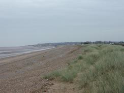
There were some subtle changes which I could notice along the coast from when I last walked it a little over a year ago; a short new stretch of sea wall had been constructed to the north of Snettisham Scalp, and diggers were busy repairing the sea wall in Heacham. But much of it had remained the same, with only the season being different. It is nice to be walking on territory that I have walked before, and the memories only add to the enjoyment of the walk and do not detract from them.
Sam was waiting for me in Heacham, and when I got to her I said that I really felt like I could go on further. We had plans to visit Cambridge this evening, and we wanted to spend some time there and so an early finish to the walk was required. However it was still very early in the afternoon, and so Sam agreed that I could walk on for another couple of miles to Hunstanton, where she would meet me. When I got there she was busy talking to a dog, and it took me a few minutes for me to drag her away.
The prime reason for going to Cambridge was to visit some friends at the dive club in Bottisham. Sam is going away for a week to the Red Sea on the sixteenth, and she wanted to finalise some of the details. Since Cambridge is only a short drive away, we felt that a visit would be a nice break from the routine that we have developed over the last few weeks. We also visited an old colleague of mine, Terry, and we went to my favourite fish and chip shop in Cambridge to eat a rather unfeasibly large plate of fish and chips. This was a highly enjoyable evening and it was nice to catch up with friends again, even after only a month away.
Directions
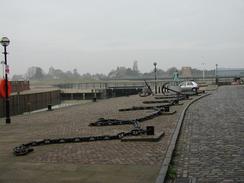
This walk starts off at the Tourist Information office in Kings Lynn, which is housed in the old customs house. Turn left out of the Tourist Information office to head north up King Street. When this ends at a large square follow Tuesday Place and then St Nichol Street. At the end of St Nichol Street turn half-left down St Ann's Street and follow this around to the right as it becomes North Street. When this ends at a junction with the A1078 road turn left and follow it until it bends sharply to the right. Go straight on to head west through a gateway into the port and head down Bank Road.
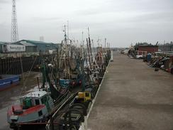
Head south-north-westwards along Bank Road and past the fishing dock. When the road turns to the right to head north-north-westwards follow it as it skirts past a series of chemical factories to the right and the River Great Ouse to the left. The road passes under some power lines before it turns sharply to the right just over two kilometres after the docks.
The road becomes a track running along the top of a flood bank until it turns sharply to the left again at TF 6072 2307. Here a sign forbids access along the flood banks, but I walked along this sea bank northwards until a sluice over a drainage channel is reached.
Here I left the sea banks and took a more inland route. Perhaps in future the sea banks will be opened up to the public, and it would certainly make a more interesting route. Cross the sluice and then continue straight on down a track that runs to the left of a bank. This track crosses Vinegar Middle for about a kilometre until it meets a junction with another track. At this track turn right and follow it until another track junction is reached near some buildings at TF 614 251. At this junction turn left to head northwards along another track for a little under a kilometre.
This track curves around to the right for a short distance as a track heads in from the left. Follow the track as it bends around before taking a near-northerly course once more. The track rises up onto the flood banking once again near a farm building at yet another junction in the tracks. Continue straight on down off the flood bank to head north-north-eastwards once more.
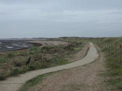
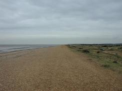
The track continues on for a little over two kilometres until it reaches another junction in the tracks at TF 647 290. From here take the track that heads north-eastwards to meet another track and a couple of buildings which are part of a drainage pumping scheme at TF 654 303.Turn left and follow a path that runs along the top of the bank past the buildings. This path slowly turns around to the right to head in a northerly direction between some lakes on the right and the sea on the left. Eventually the path reaches a car park at Snettisham Scalp. Turn right and follow the beach northwards, squeezing between the sea to the west and Heacham Harbour to the east for a few miles until you reach the outskirts of the village of Heacham.
At the first car park you reach in Heacham there are some shops so that you can buy an ice cream, and some public toilets are also there. Unfortunately both of these facilities are closed out of season, which is a real bind. The walk continues northwards along the beach, following the seafront to another car park on the northern edge of Heacham.
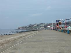
From here the walk follows the beach northwards, following the top of the concrete sea wall. As it progresses it passes many sea chalets, all of which must yave some lovely views over the Wash. The seawall continues for a couple of miles until the southern outskirts of the town of Hunstanton is reached. The seawall becomes busier as it heads northwards into Hunstanton, and fairly soon the sea life centre is reached on the right.
Distances
| From | To | Distance (m) | Ascent (ft) | Descent (ft) |
|---|---|---|---|---|
| Kings Lynn | Shepherd's Port | 11.3 | 95 | 108 |
| Shepherd's Port | Hunstanton sealife centre | 4.7 | 36 | 36 |
This makes a total distance of 16.0 miles, with 131 feet of ascent and 144 feet of descent.
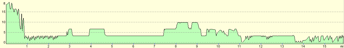
For more information on profiles, ascents and descents, see this page
Accommodation
For the first time on this trip so far we did not stay at a campsite. As we had gone back for the night to visit friends in Cambridge, which is only a relatively short drive south from Hunstanton, we parked up in the car park we used to use in Ditton Lane and spent the night reminiscing in the van.
Disclaimer
Please note that I take no responsibility for anything that may happen when following these directions. If you intend to follow this route, then please use the relevant maps and check the route out before you go out. As always when walking, use common sense and you should be fine.
If you find any information on any of these routes that is inaccurate, or you wish to add anything, then please email me.
All images on this site are © of the author. Any reproduction, retransmissions, or republication of all or part of any document found on this site is expressly prohibited, unless the author has explicitly granted its prior written consent to so reproduce, retransmit, or republish the material. All other rights reserved.
Although this site includes links providing convenient direct access to other Internet sites, I do not endorse, approve, certify or make warranties or representations as to the accuracy of the information on these sites.
And finally, enjoy your walking!
This walk was mentioned in the following routes:
| My walk around the coastline of Britain |
Nearby walks
| # | Title | Walk length (miles) |
|---|---|---|
| 4 | Downham Market to Watlington | 6.2 |
| 9 | Old Hunstanton and Holme | 4.0 |
| 28 | Kings Lynn to Watlington | 7.4 |
|
|

|