Walk #653: A circular walk from Welford to Foxton
 |
 |
|
General Data
| Date Walked | 05/03/2005 |
| County | Leicestershire, Northamptonshire |
| Start Location | Welford Wharf |
| End Location | Welford Wharf |
| Start time | 09.20 |
| End time | 16.19 |
| Distance | 20.6 miles |
| Description | This was a long walk around the Northamptonshire / Leicestershire border, taking in long sections of canal towpath and the Jurassic Way. |
| Pack | Today I carried my 30-litre Karrimor HotRock rucksack, which was filled with two litres of water, a spare fleece and various electronic gadgets. |
| Condition | I feel absolutely fine after this walk, and have no problems to report. |
| Weather | Today was a bitterly cold day when exposed to the wind. Initially there was some sunshine, but the clouds soon became dominant and I was faced with a snowstorm that lasted for a couple of hours in the afternoon. |
| OS map | Landranger number 140 (Leicester, Coventry & Rugby) and Landranger number 141 (Kettering, Corby & surrounding area) |
 |
 |
|
 |
 |
|
Map of the walk
Maps courtesy of Google Maps. Route for indicative purposes only, and may have been plotted after the walk. Please let me have comments on what you think of this new format. For a detailed table of timings for this walk, please see the table file.
Notes
I really wanted to do a walk this weekend, but I had been ill with the flu over the early part of last week and so I was unsure about how much walking I could physically do. I was feeling very grotty when I woke up this morning with my nose in full flow, but I pulled myself out of bed and thought about where I wanted to walk. A walk from Leicester to Loughborough following the river was quite tempting, but that would have involved a relatively long drive that I did not feel up to. Instead I decided on doing a walk that has only been in my plans for a couple of months; one day when travelling down the A14 I got diverted off via the A5199 (the old A50), and when passing through Welford I saw Welford Wharf, which looked like a nice place to base a walk.
Studying the map for a while showed an obvious route choice that involved following the canal northwards to the spectacular Foxton flight of locks, and then heading back along the Jurassic Way long-distance path. The route having been chosen, I piled my kit into the car and headed off down the A14 to make my way to Welford. When I got there I drove through the village looking for a place to park near the church; there was nowhere obvious so I carried on until I reached the wharf, where there turned out to be a large and handy car park. I parked up and started to stretch my legs by walking around the immediate area of the Wharf. This was quite interesting as there are several informational notice boards (including some short walks based on the Wharf) and some old lime kilns that had recently been semi-restored to allow the public to see how the fabric of the brick-built structures.
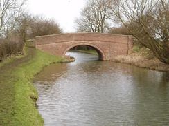
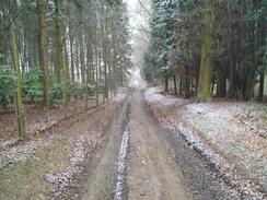
I soon headed back to my car, hoisted my rucksack onto my back and headed of down the canal. There were many canal boats tied up at the Wharf (which is at the end of the Welford Arm of the Grand Union Canal Leicester Section), and a few of these showed some activity this morning. After a couple of hundred yards I reached Welford Marina, and as the wooden bridge over the marina entrance was closed for repairs I had to make a little diversion around the marina, which was no great hardship. Once I was back on the towpath I passed the attractive Welford Lock, where the towpath changed to the other side of the canal, and started heading towards the junction with the Grand Union Canal. It soon became apparent to me that it was going to be a bitterly cold day, as when I was exposed to the cold wind I could feel my temperature plummet. This made me feel even worse, and annoyingly when I was sheltered from the wind I was reasonably warm, so I decided not stop to put my coat on as my fleece was coping admirably.
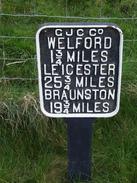
The junction of the Welford Arm with the canal proper was not particularly noteworthy, except for the obligatory fingerposts showing distances to various point on the canal. I was soon heading north, and before long I found myself in a deep cutting that protected me from the wind. The canal wound around in the cutting before entering the southwestern portal of Husbands Bosworth Tunnel. I could see the other portal as a gleaming white light through the length of the tunnel, and as usual on such occasions the light belied the length, a fact that soon became apparent as the towpath climbed steeply uphill before descending. It was easy to follow the path as it crossed the A5119 before almost immediately meeting the course of an old railway line, which it paralleled before descending down to the northeastern tunnel portal and the canal towpath once more.
The next stretch of towpath was actually quite hard to walk along, as it was very muddy and in some places had eroded away almost entirely. I had to go quite slowly on occasion and be very careful how I placed my feet, and a couple of times I found my feet slipping downwards towards the water. Walking on such paths always takes a great deal of energy out of me, as the muscles work so much harder to try and prevent slipping. Fortunately the muddy and eroded stretch soon ended, and I found myself striding along northwards, and then northeastwards, towards the topmost of the ten locks of the Foxton flight. As I did so it started to lightly snow, and I decided to put my coat on. As soon as I did so the snow stopped, but I continued on along the towpath with the zip undone to try and prevent overheating
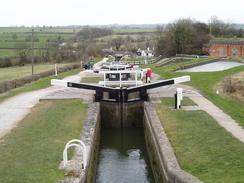
The Foxton locks are quite unusual; most locks have two gates, but at Foxton one lock leads directly into another, and consequently the majority of the locks only have one gate. It makes for a very impressive sight when standing on one of the lower locks and looking up the flight, which was something that I did frequently as I descended. There is a museum just before the bottom lock is reached, and whilst I was tempted to go in for a look around I realised that I was very muddy and still had a long way to go, so I kept on going. A bridge carrying a bridleway over the canal is reached just before the bottom lock, and here I bade farewell to the canal for the day. A pub is under renovation here and is due to open later in the year; it was a shame that it was not open today as I could really have quaffed down a pint. The bridleway headed eastwards for a short distance, passing a boatyards with a narrow boat resting on top of a shipping container before ending at a road near Foxton Church.
I had planned to take a footpath that headed south to Lubenham to the east of the road, but I could see from the junction that the path was indistinct on the ground and so I chose to walk south along the road instead. This was not a bad choice, and I soon found myself walking through the village to the attractive little church, which proved to be well worthy of a couple of photos. Right next to the church is an old railway bridge, a wide double-arch structure that carried the line overhead from the adjoining embankments, and as I walked under I was passed by an attractive jogger. I soon left the road and started following a footpath that headed southwards, climbing uphill across fields to skirt some woodland; as I descended down the other side the path became fairly boggy until I reached a stile that was surrounded by a pool of water. Fortunately I did not have to wade through this as the adjoining fence was damaged and I could just walk through to the next field,
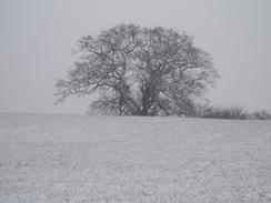
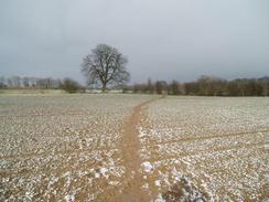
Just before the path met the church in East Farndon I encountered a finger post standing prominently alone in the middle of a field. This proclaimed the course of the Jurassic Way, which I would be following all the way back to Welford. The path was easy to follow as it headed southwestwards, but fairly soon it started to snow. As I walked onwards it got increasingly heavy and was annoyingly being blown into my face; after a few minutes I got my balaclava out of my pocket and put it on to try and keep my cheeks warm. Despite cold legs (I had not bothered to put my waterproof leggings on this morning) I enjoyed the walk through the snow; the path was easy to follow and I therefore had no route-finding problems, and the scenery soon took on a strange monochrome look. As I walked through the grass the toecaps of my boots were picking up large balls of slush, and the front of my coat and the breast pockets on my rucksack had developed a thin layer of ice, probably due to the wind chill for it was not a cold day.
The snow had mostly stopped by the time that I reached Sibbertoft and walked past the church along the road. Not much had settled on the roads, but the path heading southwestwards towards Sulby was again covered with snow. This started melting fast, and by the time that I reached Sulby Reservoir most of it had melted. The reservoir was quite attractive and by the looks of the parked cars attracted a fair few anglers, but I could not get very good photographs due to the sun glaring off the water's surface. The reservoir is actually in two halves, one lower then the other, and the path crossed between the two on the dam of the higher reservoir. A short path took me on to a road within sight of Welford Wharf; however I realised that I still was not very tired and so I decided to extend the walk by walking on up into Welford.
The most obvious way of doing this was by continuing on along the Jurassic Way, which I did as it headed along a road before heading southwestwards to the east of the village. I eventually left the path and headed through a farmyard that was home to a very excited Collie, which proceeded to jump up and put muddy paw prints all over my trousers and coat. Once I had safely negotiated the farmyard I walked along the road towards the church, and then on along a back road through the pretty little village. As I did so it started to snow, and so I increased my pace back down the hill towards the Wharf, where I was glad to see my car waiting for me. As I took my coat off inside the car I reflected on what had been an enjoyable walk, despite the fact that I had been under the weather.
 |
 |
|
Directions
This walk starts off at Welford Wharf, immediately to the north of Welford village. Head towards the Wharf and walk past the building, to join the towpath Started heading northwestwards along the towpath; After a couple of hundred yards Welford Marina is reached, where a bridge carries the towpath over the entrance. Continue on along the northern side of the canal until Welford Lock is reached, where the towpath swaps over onto the southern side. It continues on this side for a mile until a bridge is reached by Bosworth Mill Farm, where it swaps back over to the northern side for the short distance to the junction with the Grand Union Canal (Leicester Section).
A bridge carries the towpath over the canal; on the western side turn right and start walking northwards along the towpath, which runs along the western side of the canal. After a couple of miles the canal enters a cutting before reaching the southwestern portal of Husbands Bosworth Tunnel. Here the towpath climbs up along an obvious and easy to follow track, before descending down to cross the A5119 road. Cross the road, and once on the other side follow the path as it crosses a bridge over an old, disused railway line and then turn right to parallel the line for a short distance before turning to the left to descend down to the southern bank of the canal by the northeastern portal of the tunnel.
Continue walking along the towpath as the canal winds its way northwards. Towards Theddingworth Lodge, where it takes a more northeasterly course until the top lock of the Foxton flight of locks is reached. Continue on down the flight of locks until just before the bottom lock is reached; here turn right and across a bridge over the canal and follow a bridleway that heads eastwards, initially passing a boatyard before climbing uphill and ending within half a mile at a road immediately to the south of Welford Church. Turn right and follow the road as it immediately curves to the left around a bend, and then take Foxton Road that leads off to the right. This road heads southwards for a couple of kilometres before ending at the A 4304 road in the village of Lubenham. Turn left along the A4304 for about a hundred yards before turning right down Rushes Lane; this heads south through the village and passes the church.
Immediately beyond the church the road passes under an imposing disused rail bridge and then curves to the left, to head eastwards alongside the railway embankment. After a few hundred yards turn right along a footpath. This heads slightly east of southwards across fields, climbing uphill and passing immediately to the east of a patch of woodland before descending downhill to meet a road to the west of East Farndon. Cross the road, and once on the other side take a footpath that squeezes past a farm as it heads southwards towards East Farndon Church. A couple of hundred yards before the church is reached a signpost stand prominently in the middle of a field; this marks the point that the footpath meets the course of the Jurassic Way, which will be followed for most of the remainder of the day.
Turn right (indeed, the path initially almost doubles back on itself) and follow the Jurassic Way as it heads westwards across fields before curving around to take a more southwesterly course. The footpath is easy to follow as it crosses a road, and continues on southwestwards towards an area of woodland. As soon as the woodland is reached the path joins an unsurfaced track that heads uphill to the west. At the top of the hill the track turns to the left as it leaves the trees, and the footpath continues on southwestwards across fields before reaching a road immediately to the north of Sibbertoft Church. Turn left and walk past the church, before turning right to head westwards along Welland Rise. This road ends at the western side of the village at another road; follow this road westwards for a few yards until a track leads off to the left.
Here turn left along a footpath that heads southwestwards across fields. After a little under a kilometre a track is reached; turn right and follow the footpath as it heads westwards along the track for about half a mile before hading off to the left. The footpath crosses fields southwestwards, descending downhill to cross Sulby Reservoir on a dam and then heading on southwestwards and ending at a road immediately to the northeast of Welford Village. Turn left along this road for a couple of hundred yards before turning right along a footpath that initially head south along a trek through a farm before heading southwestwards across fields, dropping down to cross a stream and rising up the other side. When it approaches some farm buildings leave the Jurassic Way and turn right along another footpath that heads through a farmyard before ending at the A5199 High Street in Welford. Turn left and head south along the road for a few yards before turning right down Church Lane towards the church. When the church is reached turn right and follow West Street as it heads north, eventually curving around to meet the A5199 road once again. Turn left and continue on down the hill until the Inn is reached beside the Wharf; turn left and walk past the pub to reach Welford Wharf, where this walk ends.
Distances
| From | To | Distance (m) | Ascent (ft) | Descent (ft) |
|---|---|---|---|---|
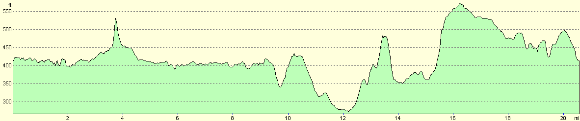
| Welford Wharf | Foxton Locks | 9.6 | 394 | 448 |
| Foxton Locks | East Farndon | 3.9 | 367 | 248 |
| East Farndon | Welford Wharf | 7.1 | 427 | 492 |
This makes a total distance of 20.6 miles, with 1188 feet of ascent and 1188 feet of descent.
For more information on profiles, ascents and descents, see this page
Disclaimer
Please note that I take no responsibility for anything that may happen when following these directions. If you intend to follow this route, then please use the relevant maps and check the route out before you go out. As always when walking, use common sense and you should be fine.
If you find any information on any of these routes that is inaccurate, or you wish to add anything, then please email me.
All images on this site are © of the author. Any reproduction, retransmissions, or republication of all or part of any document found on this site is expressly prohibited, unless the author has explicitly granted its prior written consent to so reproduce, retransmit, or republish the material. All other rights reserved.
Although this site includes links providing convenient direct access to other Internet sites, I do not endorse, approve, certify or make warranties or representations as to the accuracy of the information on these sites.
And finally, enjoy your walking!
Nearby walks
| # | Title | Walk length (miles) |
|---|---|---|
| 137 | Market Harborough to Northampton | 18.3 |
| 138 | Market Harborough to Leicester | 17.7 |
| 734 | A circular walk from Welford to Crick | 22.0 |
|
|

|