Walk #734: A circular walk from Welford to Crick
 |
 |
|
General Data
| Date Walked | 02/08/2006 |
| County | Leicestershire, Northamptonshire |
| Start Location | Welford Wharf |
| End Location | Welford Wharf |
| Start time | 08.42 |
| End time | 16.28 |
| Distance | 22.0 miles |
| Description | This was a pleasant walk following the Oxford canal southwards before heading back along footpaths and bridleways. |
| Pack | Today I carried my 30-litre Karrimor rucksack filled with my waterproofs, three litres of water, a book and various other odds and ends. |
| Condition | I feel fine after this walk, and have no significant problems to report. |
| Weather | Th day was generally cloudy with only a few breaks in the cloud. There was a slight breeze, but despite this it was still a fairly warm day. |
| OS map | Landranger number 140 (Leicester, Coventry & Rugby) |
 |
 |
|
 |
 |
|
Map of the walk
Maps courtesy of Google Maps. Route for indicative purposes only, and may have been plotted after the walk. Please let me have comments on what you think of this new format. For a detailed table of timings for this walk, please see the table file.
 |
Notes
I have never walked before on the 2nd of August, one of only five dates in the year that I have never walked on. I therefore booked today off work in order to do a walk and remove one date of that list. I did not fancy driving too far, and so I settled on doing this walk on the Leicestershire / Northamptonshire border, about an hour's drive away along the A14. The drive went well, aside from a little delay at the junction with the A1 where some road works were being started.
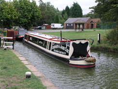
The car park at Welford Wharf was fairly quiet, with only two other cars in it, and I soon had my boots on and started walking towards the wharf, passing an information board before reaching the end of the wharf, where there were a couple of narrow boats moored up. I had walked the first couple of miles of this walk before, when I had done a circular walk north from Welford. As soon as I left the wharf there were boats moored up on the left, and shortly after this I reached a marina on the right. When I had walked along here last year the wooden bridge over the marina was closed for repair and I had had to divert around the marina. This time it was open, and I could see new pieces of wood in the footsteps as I climbed the steep steps leading up the bridge.
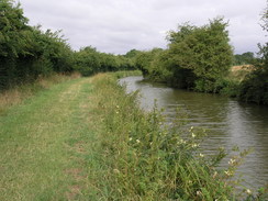
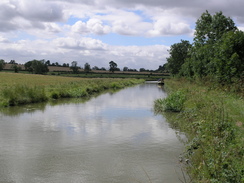
I put myself into autopilot as I walked northwestwards, passing a lock and crossing over onto the other side of the canal for a period before reaching Welford Junction, the junction with the Grand Union Canal (Leicester section). I crossed a well-maintained bridge onto the other bank, and started following the canal southwards. It was a pleasant walk, and although the day had started off surprisingly chilly for the time of year, I soon warmed up as the towpath wound around various hillocks. This canal is one that followed the contours rather than trying to bend them to its will, and thus the journey was much longer than should have been the case. This led me to wonder at what point it became cheaper to build a flight of locks or tunnel rather than follow the contours. Many later contours were straighter and cut across the landscape more, but this one meandered around in a pleasant manner.
The miles flew by, and as I walked by a moored narrowboat I heard an exclamation. This awoke me from my reverie and I looked to my left, to see a lady standing nude through a window in the side of the boat. Embarrassed, I averted my gaze and walked on, but after I had gone about twenty yards I heard a call and she was standing at the door of the boat waving at me and apologising. I waved back and, my embarrassment showing in my face, I walked on. A short distance further on there were two sheep on the towpath, and as I approached they ran on in front of me. This continued for about half a mile, with the sheep desperately trying to get into the adjoining fields where ever they could. Eventually the towpath widened as I approached a bridge, and they used this extra space to get past me. The utter stupidity of sheep has never ceased to amaze me, and this occurrence was no exception.
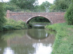
When the towpath reached the A428 immediately to the east of Crick I joined the road beside what looked like a very posh pub, the ambience persuading me not to enter. Instead I walked on for a short distance towards the village, before taking a bridleway that headed almost directly north across fields. This was the start of my return journey north towards Welford, and ahead of me I could see Crack's Hill rising. The path crossed the canal on a bridge and as I did so a narrowboat passsed underneath, the boater shouting up at me about two sheep on the towpath. He was amused when I shouted back that I knew about them, and I set off up the hill.
The climb up Crack's Hill gave me probably the bext views of the day, but soon I was heading downhill along a track to cross the canal once again and start ascending slightly up a broad track. As I walked along this I met a couple in a field who asked me if I had seen a couple of sheep; when I said that I had they asked me what they were like. I replied that I was not an expert on the distinguishing features of sheep, but that they were certainly not lambs. Amused I walked on, passing a scruffy area with old caravan and bus beside the track until I reached the village of Yelvertoft. By this stage I was getting tired, and I bought a copy of the latest Private Eye in the newsagent before heading on towards the pub.
I could not resist nipping into the pub for a quick drink, and inside I found a pleasant atmosphere. After I ordered I chatted to the landlord and a couple of locals, who seemed to be intrigued about the walk that I was doing. After a few minutes the landlord produced a leaflet on local walks that he gave me, as the talk changed to fishing and other rural matters. It was one of the friendliest pubs that I have been into this year, and it was with regret that I left to follow the road through the pretty village.
My next target was the trig pillar situated on a hillside to the west of the village, and to reach this I had planned to use a footpath that went up from the village. Unfortunately when I reached the point I could not see a point, and walked on by fifty yards before doubling back. Eventually I found the start of the footpath by a bungalow, and followed it as it squeezed in a narrow and overgrown gap between a fence and a hedge. It was hard going, particularly in one point where the fence had fallen in towards the path, and it was with relief that I reached a stile that led over into an open field.
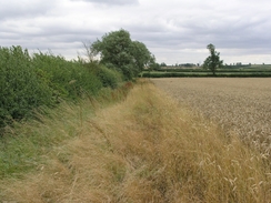
The trig pillar turned out to be in plain view in a field on the other side of the hedge, but I decided not to nip across and instead rejoined the path as it angled down to meet a road. This turned out to be fairly quiet, and only one car passed me before I took a track that headed on the level to end at a road in the hamlet of Claycoton. I got a few glimpses of the church before another footpath took me onwards as I aimed for a bridge over the A14. Initially the path was clear and easy to follow, but as I neared the A14 I reached a hedge where I could not find a stile through a hedge. I searched in vain for a few minutes as a tractor ploughed nearby, before giving up and joining a track that led up to the bridge.
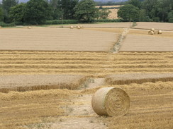
Once over the bridge the path took me past Pages Lodge Farm, before squeezing past some round bails of silage covered in black polythene and entering a field. The going was easier after this, as the path followed the edge of a field ans the sun beat down for a prolonged period, the sporadic cloud cover having been temporarily blown away. After crossing the canal via a road bridge a path led up the Hemplow Hills through a field of corn, and as I walked the field was being cut down using a combine harvester. I timed my progress carefully so that I would be able to get a good picture of the harvester and attendant tractor cutting across the track, and proceeded on as they headed away from me towards some trees.
At the top of the small hill the path emerged from the trees and cut across fields to a track, which I followed past a couple of farms until it ended at another road. Once across this I took another road that headed back towards Welford. I stopped to take a few photographs of the church, but the sun was in the wrong position and they did not turn out too well. I had walked the next stretch before, and as the road descended down through the village I put my mind into idle. Two attractive joggers passed me as I descended, and before I knew it I had reached the start of a path, that headed away from the road through a small nature reserve to reach the car park in Welford Wharf. It was the end of a long walk, but one that had been relatively easy and enjoyable.
Directions
This walks starts off at the car park at Welford Wharf. Leave the car park and head towards the pub to join the end of the Welford Arm of the Grand Union Canal (Leicester Section). The towpath runs along the northern side of the canal; follow the canal northwestwards for a couple of kilometres; after a short distance a footbridge takes you over the entrance to a marina, and later on a lock is reached, where the canal swaps over to the other side of the canal. Just before the Arm ends at a junction with the main canal, the towpath crosses a bridge to rejoin the northern side of the canal.
At the junction cross the bridge and turn left, to start heading southwestwards along the canal. Follow the canal as it winds around for a little under eleven miles on what is a pleasant walk, until the A489 is reached in Crick. Here leave the towpath and climb up onto the A489, before turning right to walk west along the road for a hundred yards to a roundabout. At the roundabout a bridleway heads north back towards the canal, crossing it at a bridge before climbing up Crack's Hill and descending down a track to another bridge over the canal. On the other side a wide track heads northwards, before ending at a road in the village of Yelvertoft.
In the village and then turn left to start following the road straight northwestwards through the village. When the road curves to the right follow it for a couple of yards, before turning left along a narrow and overgrown footpath that squeezes down beside a bungalow before entering an open field. Follow the path northwestwards as it slightly climbs up a field, before turning slightly to the right and slowly descending down towards a road. At this road turn left and follow it westwards for a few hundred yards until a track leads off to the right.
Turn right and follow the track as it heads northwards, before curving to the right to take a more easterly course, passing a barn on the right before ending at a road in the small village of Claycoton. Turn left and follow the road northwards, passing a church on the left until the road bends slightly to the left. Here, take a footpath that heads off to the right along the southern edge of a stream, heading slightly north of east, crossing a track before continuing across a field towards a bridge over the A14. In places I found the path hard to find due to impassable stiles in hedges, so instead I followed a track around to the bridge.
Cross the A14 using the bridge and follow the track as it curves to the right to head northeastwards past Pages Lodge Farm, squeezing past a barn to reach a footpath that slowly curves to a slightly more northerly heading, before reaching the canal once more at bridge 31. Join the road and cross the canal using the road; on the other side of the bridge take a footpath that heads eastwards, crossing a track as it slow rises across a field. The path enters a patch of woodland and the ascent gets steeper, heading up onto the Hemplow Hills.
The path takes a more northeasterly course as it leaves the trees, and the gradient also levels out as it heads across a field before joining a track near a farm. Join this track, and follow it eastwards for about a hundred yards before it ends at a T-junction with another track. Turn left and follow this track as it heads northeastwards past Hemploe Lodge Farm for a kilometre until it reaches another road.
Cross this road, and on the other side continue straight on along a road that leads into Welford. Continue on along this road, after about half a mile passing to the left of the church before descending downhill through the village. When the road ends at a T-junction with the A5199, turn left and continue on down a slight hill as the road curves to the left. Fairly shortly a footpath heads off to the left, passing through a small nature reserve before reaching Welford Wharf, where this walk ends.
Distances
| From | To | Distance (m) | Ascent (ft) | Descent (ft) |
|---|---|---|---|---|
| Welford Wharf | Canal junction | 1.9 | 102 | 98 |
| Canal junction | A489 in Crick | 10.9 | 323 | 331 |
| A489 in Crick | Yelvertoft | 1.9 | 72 | 118 |
| Yelvertoft | Welford Wharf | 7.3 | 417 | 367 |
This makes a total distance of 22.0 miles, with 914 feet of ascent and 914 feet of descent.
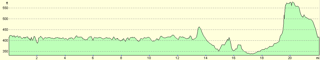
For more information on profiles, ascents and descents, see this page
Disclaimer
Please note that I take no responsibility for anything that may happen when following these directions. If you intend to follow this route, then please use the relevant maps and check the route out before you go out. As always when walking, use common sense and you should be fine.
If you find any information on any of these routes that is inaccurate, or you wish to add anything, then please email me.
All images on this site are © of the author. Any reproduction, retransmissions, or republication of all or part of any document found on this site is expressly prohibited, unless the author has explicitly granted its prior written consent to so reproduce, retransmit, or republish the material. All other rights reserved.
Although this site includes links providing convenient direct access to other Internet sites, I do not endorse, approve, certify or make warranties or representations as to the accuracy of the information on these sites.
And finally, enjoy your walking!
Nearby walks
| # | Title | Walk length (miles) |
|---|---|---|
| 137 | Market Harborough to Northampton | 18.3 |
| 158 | Bugbrooke to Braunston | 15.1 |
| 162 | Braunston to Leamington Spa | 16.6 |
|
|

|