Walk #733: A circular walk around Mersea Island
 |
 |
|
General Data
| Date Walked | 29/07/2006 |
| County | Essex |
| Start Location | Peldon church |
| End Location | Peldon church |
| Start time | 09.48 |
| End time | 17.47 |
| Distance | 22.6 miles |
| Description | This was a very pleasant walk to, around and into the Isle of Mersea in Essex. |
| Pack | Today I carried my 30-litre Karrimor rucksack filled with my waterproofs, three litres of water, a book and various other odds and ends. |
| Condition | I had a little trouble with my right knee on a couple of occasions today, which let me know that the problem that I got this time last year has not yet fully cleared up. Aside from this I suffered slightly from the heat, and it did not seem to matter how much I drunk to try and cope. |
| Weather | The day started hot and sunny, and the heat increased throughout the afternoon. The clouds slowly gathered towards the end of the walk, and there was a slight breeze that was welcome on the few occasions that I was exposed to it. |
| OS map | Landranger number 168 (Colchester, Halstead & Maldon) |
 |
 |
|
 |
 |
|
Map of the walk
Maps courtesy of Google Maps. Route for indicative purposes only, and may have been plotted after the walk. Please let me have comments on what you think of this new format. For a detailed table of timings for this walk, please see the table file.
 |
 |
|
 |
 |
|
Notes
When I did my walk around the coastline of Britain in 2002/3, there were certain stretches of coastline that I missed out for various reasons, particularly early on in the walk when I was unsure about how far I would get. One such stretch was around Mersea Island, which was not walked around as there was a long and fairly uninteresting walk to it. If it had been later in the walk I would probably have walked to it, but at the time Mike was driving Mervan, and the long walk along seawalls seemed rather uninteresting.
However since finishing the walk I have hankered after going back and completing some of these stretches, and as this one is so near to my home in Cambridge is seemed like an obvious first one to do. I therefore found myself driving down the M11 and along the main roads eastwards towards the Essex coast. The last part of the journey from Colchester southeastwards towards the start of the walk in Peldon seemed to take an eternity, and when I finally reached the village I could not find anywhere near the church in which to park. There was a village hall adjacent to the church, but a sign stated no unauthorised parking and so I drove around the village twice, before eventually parking in a side street near to the pub.
It did not take me long to put all my kit in my rucksack, and after locking the car I headed towards the pub, which I decided would officially be the start of the walk. The area around the pub was pleasant, as was the pub itself, with white walls contrasting sharply with the blue sky overhead. A footpath led away from near the pub, passing through a recreation ground before depositing me ungraciously out on a road near to the church, which I walked towards. As I walked through the gateway a man mowing around the graves asked me if I would like to go inside, but I rejected the kind offer, knowing that I still had a long way to walk.
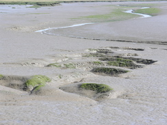
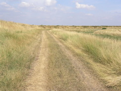
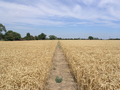
I knew that I had walked past the church on my coastal walk, and so I could be sure that I had connected up with that route, and so with a spring in my step I started off down the road away from the church. I had two options, and instead of following the road I decided to follow a footpath towards The Strood, the causeway that leads across to the island. Initially the footpath took me across fields, and to my right a combine harvester was cutting corn in the field, sending waves of dust over me as I walked. The path soon jinked before reaching the B1025, road, which I crossed to access a footpath on the over side. This soon led to some sea banking, and the large expanse of mud, interleaved by channels, showed me that the tide was well and truly out. The stroll along the banking was enjoyable, with many birds to be seen either in the air or walking along the mudflats looking for food.
The sun was rising higher in the sky and the day was getting increasingly hot as I walked, soon reaching the B10245 once again by the northern end of the causeway across The Strood. The traffic along this stretch of road was quite heavy on this Saturday morning, and it seemed like half the population of Essex were going to the seaside on Mersea Island. Fortunately there was a pavement to separate me from the traffic, but at the southern end of the causeway this ended, and I was forced to brave the traffic for a couple of hundred yards until I could join the footpath. On the map this is marked as heading around the floodbanking, but as I walked along the road I could see a couple of gaps in the sea bank. One of these seemed passable as the tide was low, but the other gap was very wide and I did not fancy my chances in even trying to cross.
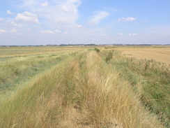
When I eventually reached the start of the footpath there was a very faded sign warning people that the floodbank was breached; the sign was so faded that I wondered if people would actually be able to read it. This left me in a slight quandary about what to do next; instead of taking a rather boring inland route via roads I decided to risk walking along another sea bank that was further inland from the breached one. This is not marked as a public right of way on the map, and although there was a vague path on the ground in places this was overgrown by prickly bushes, which did not prove to be too comfortable in my shorts. The route was definitely walked fairly often, however, as at a small breach in the bank where a stream left the fields to the right a ladder had been placed, allowing people to get across easily. The breach was only a few feet and I did no bother using the ladder, instead just striding across the mud (although at high tide it would have been harder).
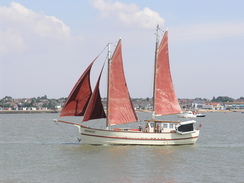
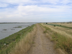
A short distance further on the bank met the seaward (breached) one, and at this end there was no sign warning people not to take the seaward one. The banking led on, and at times I chose to walk along the inland base of the bank as it was less overgrown and proved to be easier going. Near Maydays Farm a track ran along the base of the bank, and I walked along this doe a while, before having to go back onto the top of the bank once it ended. As I walked the tide was slowly coming in, ands as I passed around Reeveshall Marsh I got some good views across the channel to Pewit Island, and the channel started to become populated with boats. A little diversion around an inlet followed (although this was a far shorter diversion that that shown on the map, and I started to follow the banking around towards Mersea Stone.
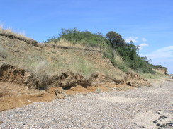
Soon the Pyefleet Channel was met by the River Colne and the Geedon Creek, and the number and size of boats on the water increased considerably. There were also more people walking along the banks, and over the water in St Osyth I could see building work going on. Whereas the first few hours of the walk had been solitary I was now with many other people, and I cut across a concrete path by a flood warning sign to reach Mersea Stone. This is the site of an artillery fortification built by Henry VIII in 1543 that guarded the mouth of the River Colne. It was a triangular earthwork bulwark, with semi circular bastions at the apex of each 300 foot long side. However SMR record reads "Fort with 4-6 guns, ditch and drawbridge built in 1547. It was allowed to fall into decay but repaired in 1587 and was still considered effective in 1631. By 1656 it was in use as a house". A single turret is apparently visible from the air in the saltmarsh beyond the sea wall.
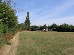
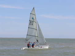
There was no signs of this on the ground, on a pebbly beach that was fairly packed with people. There was a tent nearby, and people were splashing around in the water as some fairly large vessels passed by. A surfer with a paraglider came to a stop beside me as I turned the corner and started heading southwestwards, and he had trouble trying to get the parasail down into the water as the wind kept on picking it up once again. A little further on I reached the Cudmore Grove Country Park, and I left the beach and stared walking along the cliff edge instead. Off to my right in the car park I saw a glimpse of an ice cream van, and because of the hot weather I decided to nip over. I actually bought an ice cream cone and an ice lolly, and went to sit over on a bench near the small visitor centre at the edge of the car park. The sun was blazing down, and I chatted to a family at an adjacent picnic table as I let the ice cream cool me down.
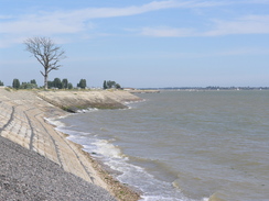
Refreshed, I set off once again, following the cliff edge before dropping back down onto the beach. This was fairly busy despite being pebbles rather than sand and there were many boats close in to shore. It was an enjoyable stroll, and I soon climbed onto a short stretch of concrete seawall, which halfway along had a second world war pillbox set into it - the wall had obviously been raised since the war, half burying the pillbox in the process. After the seawall ended I continued along the beach towards West Mersea, as the sun beat mercilessly down on my head. I was rapidly running out of water, and although it was an enjoyable walk I started to feel slightly dehydrated.
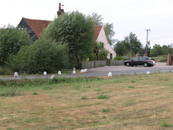
Once in West Mersea I followed a lane away from the beach, to do the next stretch of the walk up to the trig pillar in the centre of the island. This led me up the B1025 road northwards through the town, passing a Land Rover specialist before turning off down a minor road eastwards. After about a kilometre there was a pub, and I decided to stop off for a drink. There was a wedding party in the pub and it took me a few minutes to get served, but once I had received my two pints of orange and lemonade I went to sit outside on a bench, taking my boots off with relief. The views over the car park were not particularly good, but I enjoyed the rest as my mind wandered over many topics.
The first pint soon disappeared, but I took my time over the second, letting the liquid cool me down. Eventually I could delay no longer, and I shouldered my rucksack and headed off down the road. This soon curved to the left, and I continued on along a track for a short distance, before a footpath led off to the left, heading northwards beside a hedge to end at another road. My target of this diversion was a trig pillar, and I soon found this beside the road a few yards away from the path. It was buried in brambles, and in the course of trying to get a photograph of the pillar I ended up cutting myself a couple of times on my hands and legs.
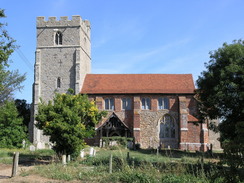
Satisfied at having found another pillar I walked west along the road until shortly after a crossroads, where I followed a path west. This was across fields that were waist-high with rough-stemmed plants that struck my bare legs and made them sore. It was therefore with relief that I reached the B1025 road, as on the other side the path was clearer, and I made good time along this path back to a road. This led me on through the town back to the shore, slightly west of where I had left it a couple of hours before. Unfortunately there was not much to note in town, the only architecturally pleasing building that I saw being the church, which was half-hidden from the road.
Once back at the shore I did not join the beach but instead followed a road that skirted the shore, heading up towards the western tip of West Mersea. The road was quiet to walk along but was fairly busy with people, there having been some sort of fête going on. I diverted off the road to visit St Peter's Well, a Holy Well formerly attached to the now vanished priory of St Peter and St Paul and formerly one of the main supplies of fresh water for West Mersea. From there I then headed along the road, passing rows of houseboats before reaching the lifeboat station. Again the area around here was bustling, and people seemed to be enjoying themselves in the bright sunshine.
After passing the lifeboat station I joined a footpath that headed northwards along a seawall beside the sea, with corn fields away to my right and the Strood Channel to my left. Boats were speeding up and down he channel, a couple pulling skiers and another a large inner tube with a bloke sitting in it. Unfortunately the latter was finding it hard to stay in the ring, as whenever the boat hit the wake of another boat in the already choppy seas he would be tossed out. Eventually the path headed inland before ending at the B1025 road, which was fairly busy with traffic heading off the island. As I walked along this I passed a youth pushing a motorbike, his engine having failed a short distance away. The road was slightly winding, so as I went round one bend I waved at the traffic to slow it down slightly before it reached him.
Where the Strood channel had been an expanse of mudflats this morning, the tide was now high and there was no mud to be seen. It was a pleasant walk across the short causeway, and I watched boats come in to be pulled out of the water at the car park at the northern end of the causeway. I followed the B1025 for another kilometre, a journey slowed down by my having to step into the verge frequently to avoid cars coming towards me. It was therefore a relief when I reached a pub, where I took a road back towards Peldon. This road was quieter, and I soon found myself passing the pub to reach my car, at the end of what had been a very hot but rewarding day's walk.
 |
 |
|
Directions
This walk starts off at the Peldon plough pub, in the village of Peldon in Essex. Leave the pub and turn left for a few yards, before turning left to head northwards up a footpath. This heads uphill through the centre of the village, before reaching a road near the church. Turn right and follow this road northeastwards; pass a road junction on the right and continue on for a short distance. Just before a right-hand bend a footpath leads off to the right; take this and follow it as it heads roughly southeastwards across fields. After a while it crosses another path, where it jinks to the left and then the right to continue in the direction that it was going before. After about a kilometre from the road the path turns ninety degrees to the left to start heading in a northeasterly direction with a hedge to the left.
After a couple of hundred yardsd the path curves once again to head in a more easterly direction towards the B1025 road. Cross this, and on the other side continue along the footpath as it climbs up onto a low floodbank, which then winds around before settling on a southeasterly course for a few hundred yards before it ends at a sea bank. Climb up onto this, and start following it as it heads south, with marshy ground and muddy creeks on the left. After a while the bank turns to the left to take a more southeasterly course, although still winding slightly before finally turning to the right and ending at the B1025 at the northern end of the causeway over the Strood.
Cross the Strood; there is a pavement that makes this task easier, although this ends shortly after the end of the causeway. When the B1025 curves away to the right at a road junction continue straight on along another road for about a hundred yards, taking care as the road is busy and fairly narrow. When a flood bank appears on the left join it, but head straight on northeastwards rather than doubling back along another stretch of seawall. On the maps there is a footpath heading along the latter course, but this is now breached in a couple of places, so you have to take another seawall further inland.
This seawall is fairly overgrown in places but was not too hard to follow, and it soon was rejoined the footpath along the main seawall. There was only one tricky gully to pass on this diversion, which may be tricky (but certainly doable) at high tide. Continue along the seabank as it winds northeastwards, passing Mayday's Farm and Mayday's Marsh, before settling on an easterly course as it heads along the southern side of Pyefleet Channel, with Reeveshall Marsh on the right. The path diverts around a little inlet, before continuing on towards Mersea Stone.
When the seabank turns to the right at the most easterly point of Mersea Island, leave the sea bank and follow a path that heads eastwards to a beach. Mersea Stone itself is a slight distance away to the north if you wish to visit this; if not, turn right and start following the beach southwestwards towards Cudmore Grove Country Park. When the park is reached, you can divert up into the park to visit the visitor's centre, or alternatively if the tide allows continue on along the beach. Continue along the shore for a couple of miles, passing rows of beach huts on the outskirts of West Mersea before the end of a road is reached.
Follow this road northwards; after a few hundred yards it joins the B1025 road for a short distance, until East Road leads off to the right. Turn right and follow East Road eastwards for about a mile until the road curves sharply to the left to become Chapmans Lane. At this point head straight on along a track, passing a house on the left before turning left along a footpath. This follows a hedge northwards, before ending after a few hundred yards at East Mersea Road.
Turn left and follow this road westwards to a crossroads with Chapmans Lane; continue straight on for another few yards, and after the first house on the left turn left southwards along the edge of a field. After a few yards the footpath turns to the right to head westwards across the field, crossing a track before reaching Dawes Lane. Cross this road, and continue on along he footpath on the other side as it heads slightly south of westwards for a little under a kilometre, heading immediately south of Wellhouse Farm to reach the B1025.
Cross the B1025, and on the other side follow a footpath that initially follows a track before heading along a footpath, curving to head southwestwards before ending at a bend in the road. Join this road and head south down High Street North, which soon becomes the B1025 High Street as it heads towards the coast. Before the coast is reached turn right to follow Coast Road as it skirts around the coast towards the lifeboat station.
When the road ends continue straight on along a footpath that turns left to join the sea bank, which initially heads northeastwards with a marshy area to the left, before curving sharply to the left and right to regain a northeasterly course, with the Strood Channel to the left. After about a kilometre the sea bank curves inland to reach the B1025 road.
Turn left and carefully follow the B1025 as it heads northwards, soon reaching the causeway across the Strood. Continue on along the B1025 as it heads northwestwards for about a kilometre until a pub is reached at a road junction. Here turn left, and follow Mersea Road westwards for about a mile into the village of Peldon. At a junction turn left down Peldon Road; after a hundred yards the Peldon plough pub is reached on the right, where this walk ends.
Distances
| From | To | Distance (m) | Ascent (ft) | Descent (ft) |
|---|---|---|---|---|
| Peldon | Mersea Stone | 8.8 | 161 | 205 |
| Mersea Stone | Trig pillar | 6.9 | 200 | 135 |
| Trig pillar | Peldon | 6.9 | 151 | 172 |
This makes a total distance of 22.6 miles, with 512 feet of ascent and 512 feet of descent.
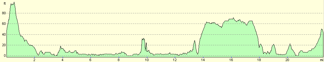
For more information on profiles, ascents and descents, see this page
Disclaimer
Please note that I take no responsibility for anything that may happen when following these directions. If you intend to follow this route, then please use the relevant maps and check the route out before you go out. As always when walking, use common sense and you should be fine.
If you find any information on any of these routes that is inaccurate, or you wish to add anything, then please email me.
All images on this site are © of the author. Any reproduction, retransmissions, or republication of all or part of any document found on this site is expressly prohibited, unless the author has explicitly granted its prior written consent to so reproduce, retransmit, or republish the material. All other rights reserved.
Although this site includes links providing convenient direct access to other Internet sites, I do not endorse, approve, certify or make warranties or representations as to the accuracy of the information on these sites.
And finally, enjoy your walking!
Nearby walks
| # | Title | Walk length (miles) |
|---|---|---|
| 269 | Clacton-on-Sea to Brightlingsea | 18.8 |
| 270 | Brightlingsea to Fingringhoe | 15.2 |
| 271 | Fingringhoe to Tollesbury | 16.7 |
|
|

|