Walk #732: South Downs Way: Glynde to Eastbourne
 |
 |
|
General Data
| Date Walked | 15/07/2006 |
| County | East Sussex |
| Start Location | Glynde station |
| End Location | Eastbourne station |
| Start time | 09.30 |
| End time | 17.46 |
| Distance | 21.6 miles |
| Description | This was a beautiful walk on a very hot day, following the South Downs Way over the Seven Sisters and Beachy Head to its end in Eastbourne. |
| Pack | Today I carried my 30-litre Karrimor rucksack filled with my waterproofs, three litres of water, a book and various other odds and ends. |
| Condition | I felt fine for most of the walk, until the last descent down into Eastbourne, when I suddenly felt nauseous and was sick twice. After this I felt distinctly unwell, and I have no idea what caused this. |
| Weather | The day was hot and sunny, although thankfully there was a nice sea breeze that helped keep me cool when I was on the tops. |
| OS map | Landranger number 198 (Brighton & Lewes, Haywards Heath) and Landranger number 197 (Chichester & The South Downs, Bognor Regis & Arundel) |
 |
 |
|
 |
 |
|
Map of the walk
Maps courtesy of Google Maps. Route for indicative purposes only, and may have been plotted after the walk. Please let me have comments on what you think of this new format. For a detailed table of timings for this walk, please see the table file.
 |
 |
|
 |
 |
|
Notes
As it had been a month since I had last done a walk (mainly due to weddings and other commitments) I really wanted to do a walk this weekend. At about six this morning I therefore found myself packing my tent and other camping equipment into my car, and set off to drive down towards Eastbourne for the final day of the South Downs Way. My plan was to walk from Glynde to Eastbourne today, to complete the National Trail footpath section, and to walk the bridleway section from Alfriston to Eastbourne tomorrow. The drive went very well, although the slow, single carriageway roads from the M25 down towards Eastbourne meant that it took me longer than I expected.
I parked in the car park at Glynde near the paragliding school that occupies the station building, and locked up my car, glad to see that there was scarcely a single cloud overhead. I was surprised to see that I was last here five weeks ago; it seemed to be much more recent. After setting off I passed the pub in the village and then walked up to the A27, after which another road took me south, soon ending at the start of the long climb up to the South Downs Way, which runs along the top of the hills. The views from the climb were expansive, and although it was a steep climb I did not find it too hard to cope with, and I reached the signpost that marked the Way sooner than I had planned.
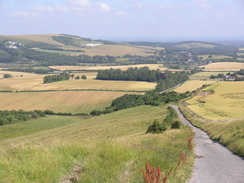
There was a pleasing, brisk sea breeze at the top, and this soon cooled me down after the long climb, as I headed along towards and past the dual masts of the radio station on Beddingham Hill. There were a few people about, walking or cycling along this superb stretch of path, which descended down to a little car park before climbing uphill once more, straight up to the trig pillar at the summit of Firle Beacon. The views from here were good, and I stopped for a minute to take them in before starting the descent down from the beacon southeastwards to another car park. A short climb took me up onto Bostal Hill, and this was followed by a gradual descent towards Alfriston.
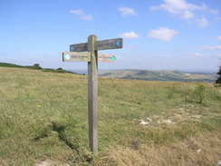
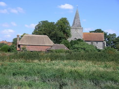
The descent became steeper as the path approached the village, and unexpectedly I found myself on a road with houses, a slight shock to the system. The descent continued onwards, before reaching some beautiful streets in the centre of the village, with pretty buildings and some relatively narrow streets. I did not visit a rather nice looking pub, but instead walked on towards the village green and the church, before crossing a white footbridge over the Cuckmere River to reach the eastern bank. Here there was a signpost marking a junction in the Way, with the bridleway section continuing eastwards to Eastbourne, and the longer footpath section heading south to Cuckmere Haven and the Seven Sisters.
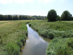
I was is two minds about which route to take, but as I was feeling fit I decided to walk the footpath section. I therefore headed south as the Way followed the river southwards, with some superb views over the river towards the church and the Old Clergy House (the first property bought by the National Trust). It was a very pleasant stretch of path, and I chatted to some people out for a stroll before the path left the floodplain to join a road in the little village of Litlington. I soon reached the Plough and Harrow pub, and as I had done a good distance so far during the day I decided to nip in for a drink.
Once inside, I could see they had a nice menu, so for once I decided to order a ploughman's meal instead of my usual packet of crisps. To wash this down I bought a pint of bitter and a pint of orange and lemonade, and sat down to eat whilst the pub slowly started to fill up. The food was delicious and filling, and I had another pint of bitter whilst I ate. After about half an hour I knew I would have to set off, and so I packed up my rucksack and started walking through the village. Almost immediately I was faced with a short but sharp climb, which was followed by an equally steep descent down to some woodland and Charleston Manor, where there were many cars parked in a field.
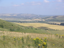
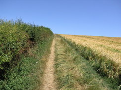
Another steep ascent followed through some woodland, and again this descended down to the village of Westdean. In this village I got slightly navigationally challenged and went a couple of hundred yards off track; I soon managed to retrace my steps and start uphill once more through some woodland as the path climbed up some rough steps. At the top the path emerged from the trees, and there were some superb views southwards over the Cuckmere valley, with the winding old route of the river to the left and the straighter new cut of the river. It was a magnificent sight, and I soon found myself down at the A259, near a car park in Exceat. Here I remembered meeting Sam in our motor home, Mervan, when I was on the coastal walk, having just walked the Seven Sisters. It was a pleasant memory, and it helped me up yet another climb as the Way forewent the flat path beside the river and instead climbed up the flank of Exceat Hill, before dropping down to Foxhole.
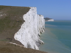
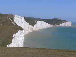
By this time I was starting to find the constant rise and fall of the Way tiring and somewhat monotonous, and I was well aware that there was more of the same to follow. However the next climb up Haven Brow to Cliff End was relatively gentle, and was made interesting by the superb views back over the pebbly beach at Cuckmere Haven. The top of the climb marked the western end of the Seven Sisters, and what followed was a superb stroll along the undulating cliff edge. Then views along the cliffs were superb in places, and I would occasionally get myself as close to the edge as possible to get some good photographs of the full height of the chalk cliffs, glinting white in the sunshine.
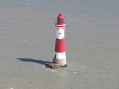
I gave myself a challenge of overtaking as many people as possible as I walked along, and as the path rose and fell I slowly overtook many of the people in front of me. Unfortunately I started to get an urgent desire to go to the toilet, and as there was nowhere private nearby and the path was understandably busy, I put an extra push on to reach Birling Gap, where I knew there was a toilet. After thankfully visiting the toilets I wandered around the buildings at the gap, and bought an ice lolly as I followed the path as it climbed uphill to reach Belle Tout lighthouse. This old lighthouse, now a private residence, was the original lighthouse, but was replaced in 1902 by the more famous lighthouse nearer Beachy Head. Belle Tout lighthouse was moved a short distance away from the cliff edge in 1999 due to erosion, and the rough tarmac track that led to it was also becoming a victim of the erosion, with only a couple of feet left in one place between the track and the cliff edge.
The path descended once more, before starting to climb towards Beachy Head. As I walked I started to see occasional bunches of flowers by the edge of the cliff, and I stopped atone of these to read a tribute to a man who had killed himself at this famous spot. I find it very sad that people use such a beautiful place to end their lives, and I found myself giving a quick prayer to all the people who have died here as I walked along.
Beachy Head soon arrived, and I bypassed the pub and continued along the Way, which stuck to the top of the cliffs. As I started the final descent I suddenly felt nauseous, and this feeling grew worse as I got lower. Suddenly and unexpectedly I was sick, and my stomach cramped up as it emptied. Feeling weary and dizzy I washed my mouth out and drunk more water before continuing, only to be sick once again five minutes later. I was feeling dizzy and the path was fairly narrow, forcing me to take care as I descended to reach the end of the South Downs Way at the very southern edge of Eastbourne.
At the bottom I sat down on a bench by a little café, all thoughts of food clearly wiped form my mind. I sat down and waited for the dizziness to fade, chatting to some people getting ready to walk the South Downs Way. Usually when I finish a National Trail I get a great sense of achievement, but that was totally lacking. Mainly this was due to the cramps in my stomach, but it was also due to the fact that I have not yet walked the bridleway stretch of the trail from Eastbourne back to Alfriston. It had been my intention to walk that tomorrow, but all thoughts if camping overnight had disappeared from my head, and I made the decision to head back home for the night.
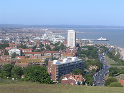
To get to Eastbourne station I decided to follow the promenade, and so as soon as I could I dropped down a track that led from the road to the promenade. There were many people sunbathing on the pebbly beach and the promenade itself was very busy, and a man on roller blades nearly knocked me over as I walked past. As the promenade approached the pier the beach got busier, and I was pleased to see that the attractive pier appeared to be doing brisk business, as was a place renting sun loungers for five pounds a day. I left the promenade so I could walk directly under the pier, and rejoined it to walk on. The station was a short distance inland from here, but as there was a little under an hour to the next train I strolled on, before eventually walking across the beach to stand by the waterline, letting the waves lap over my boots.
After a couple of minutes spent staring out to sea, I reluctantly left the beach and started back along the promenade before following roads through the town towards the station. Once away from the seafront the architecture declined in quality, and aside from a pretty church the buildings were fairly undistinguished. It was a relief when I reached the station, and I had twenty minutes to wait after buying my ticket before the train was due to leave. It was a twenty minute trip back to Glynde, and as the train rocked and swayed I started to feel nauseous once again; fortunately it came to nothing, but I drove back to Cambridge feeling fairly ill. I am unsure what has caused the illness, but I was not on top form when I left Cambridge this morning, so I can only assume that it was something that ate yesterday.
Directions
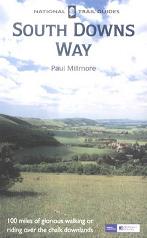
The walk is also covered in detail in the South Downs Way National Trail Guide, by Paul Millmore, ISBN 1 85410 966 9 published by Aurum Press Ltd.
The exception to this is at the start and end of the day. At the start of the day, leave Glynde station and turn right, to follow a road as it heads southwards past the pub for a little under a mile to the A27. Cross the A27, and on the other side continue on southwards along a road, which slowly climbs. Once the road goes through a gate the surface underfoot becomes rougher and the path start to climb steeply. It curves slightly to the right for the final part of the climb, before reaching a junction with the South Downs Way by a signpost on Beddingham Hill, slightly to the east of the radio station on the hill.
The South Downs Way end at a signpost by a cafe after the path has dropped down to meet the B2103, Duke's Drive. Head straight on along Duke's Drive as it heads northeastwards, becoming King Edwards' Parade. When a track leads off to the right after a short distance, follow it as it heads downhill to meet the promenade. Join the promenade and follow it as it heads northeastwards for about a mile and a half, passing the pier. It is then a case of turning left to make your way through the town to the railway station; I continued along the promenade for a distance, before turning down St Alibyn's Road to the A259, before turning right along Langley Road to the A259, Susan's Road. Turn right and follow the A259 northwestwards for a couple of hundred yards until it curves sharply to the left; follow it as it does so, until Eastbourne station is reached on the right.
Distances
| From | To | Distance (m) | Ascent (ft) | Descent (ft) |
|---|---|---|---|---|
| Glynde station | Beddingham Hill | 1.9 | 574 | 16 |
| Beddingham Hill | Alfriston | 5.2 | 400 | 971 |
| Alfriston | Cliff End | 5.2 | 978 | 719 |
| Cliff End | Beachy Head | 4.7 | 2500 | 2244 |
| Beachy Head | Eastbourne station | 4.6 | 154 | 663 |
This makes a total distance of 21.6 miles, with 4606 feet of ascent and 4613 feet of descent. (Note, I do not necessarily trust the ascent and descent values from Cliff End to Beachy Head; measuring climb along cliffs using automated software is very difficulty, as sometime it drops off to sea leevl due to the granularity of the height measurements in the software).
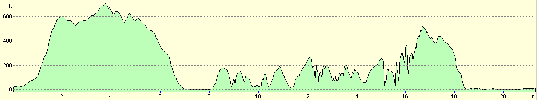
For more information on profiles, ascents and descents, see this page
Transport
There are hurly train services on weekdays and Saturdays between Eastbourne and Glynde stations; a single ticket cost me Ł4.10.
Disclaimer
Please note that I take no responsibility for anything that may happen when following these directions. If you intend to follow this route, then please use the relevant maps and check the route out before you go out. As always when walking, use common sense and you should be fine.
If you find any information on any of these routes that is inaccurate, or you wish to add anything, then please email me.
All images on this site are © of the author. Any reproduction, retransmissions, or republication of all or part of any document found on this site is expressly prohibited, unless the author has explicitly granted its prior written consent to so reproduce, retransmit, or republish the material. All other rights reserved.
Although this site includes links providing convenient direct access to other Internet sites, I do not endorse, approve, certify or make warranties or representations as to the accuracy of the information on these sites.
And finally, enjoy your walking!
This walk was mentioned in the following routes:
| The South Downs Way |
Nearby walks
| # | Title | Walk length (miles) |
|---|---|---|
| 296 | Winchelsea Beach to Normans Bay | 17.6 |
| 297 | Norman's Bay to Beachy Head via Eastbourne | 10.8 |
| 298 | Beachy Head to Peacehaven | 16.7 |
|
|

|