Walk #729: South Downs Way: Hasscoks to Glynde
 |
 |
|
General Data
| Date Walked | 04/06/2006 |
| County | West Sussex, East Sussex |
| Start Location | Hassocks station |
| End Location | Glynde station |
| Start time | 07.33 |
| End time | 15.37 |
| Distance | 20.2 miles |
| Description | This was a long day following the South Downs Way, which although not as spectacular as yesterday's walk, was still very scenic. |
| Pack | Today I carried my 30-litre Karrimor rucksack filled with my waterproofs, three litres of water, a book and various other odds and ends. |
| Condition | I had trouble today with the undersides of my feet, which were fine during yesterday's longer walk, but gave trouble after about five miles today. I put this down to overheating, but despite taking my boots off during the stops they started aching again a couple of miles later. It is annoying to have had my body limit my mileage, for the first time in a while. |
| Weather | The day was hot, with a thin layer of high cloud covering the sun for significant periods. The cooling breeze of yesterday was still present, and this proved to be equally welcome. |
| OS map | Landranger number 197 (Chichester & The South Downs, Bognor Regis & Arundel) and Landranger number 198 (Brighton & Lewes, Haywards Heath) |
 |
 |
|
 |
 |
|
Map of the walk
Maps courtesy of Google Maps. Route for indicative purposes only, and may have been plotted after the walk. Please let me have comments on what you think of this new format. For a detailed table of timings for this walk, please see the table file.
 |
 |
|
 |
Notes
I did not have a brilliant night's sleep, due to a combination of the sunburn on the back of my legs hurting when I rolled over, and some music that some idiot turned on at about three in the morning. I could not clearly hear this, but the distinct deep thump of a beat was just loud enough to keep me awake for a while.
As usual when camping, I awoke at around dawn, but unusually managed to drop off to sleep again. At about six in the morning I woke up, and wrote for a while on my laptop before getting up. After my ablutions I put my tent down, which was wet with dew, and packed up my tent, before setting off at a little past seven. During the short drive to the station I stopped off at a shop and got some spare batteries for my GPS - another thing that I had forgotten yesterday. I was pleased to find that the parking at the station was free on Sundays, and started to get ready to head off on the walk. I was delayed, however, as the headphones on my Walkman got trapped down the passenger seat, and it took me ten minutes to free them, fortunately without damaging them in the process.
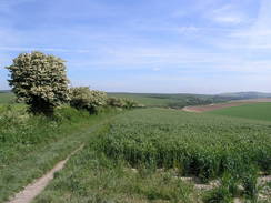
Despite this it was still probably the earliest start of the year so far, and I crossed under the railway line using the subway to reach the front of the station, and the point where I had finished yesterday's walk. The first part of the walk was simply a retread of yesterday evening's walk, following the railway line to Clayton. On the way I started to feel the heat - despite the early hour it was quite a hot day. I had got sunburnt on the backs of my legs yesterday, and to avoid the same thing happening again I had worn long trousers, but the fabric was rubbing against the burn, causing a little discomfort that I eventually got used to.
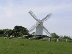
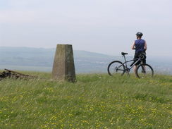
At Clayton I started the steep climb up to the Jack and Jill windmills, and I was soon puffing away at the exertion. It felt hotter than it had done last night, and I did not seem to be able to get as good a view of the windmills for some photographs. The white post mill - named Jill - look superb, and rather puts the privately-owned brick-built mill, Jack, in the shade. They are both in prominent positions on the Downs, and it is easy to see why people refer to them as landmarks on the South Downs Way. I did not stop to have a look around, and instead climbed the short distance uphill along a path and track to meet the junction with the South Downs Way.
This led me further uphill to the east, along an nice and gradual slope that proved easy to keep a good pace up. The ascent stopped at Keymer Post, where there is a pretty wooden fingerpost pointing out the four paths that meet at this point. From here I would be following a route that I walked on a previous occasion for much of the day, and to a certain extent this made it slightly less interesting than the virgin territory of yesterday had been. It took me a surprisingly long time to reach the tourist honeypot of Ditchling Beacon, and I was surprised to find a circle of people surrounding the trig pillar. As I approached I could hear singing, and I realised with surprise that there was a service going on. I arrived during the last hymn, and as they all started packing up I chatted to a few of them. Apparently it was a Pentecost service, and the white cloth that had been draped over the pillar had a bottle of wine, a small crucifix and glasses on it. Standing beside the pillar was a vicar who had a violin in his hands (at least I think it was a violin - I am musically challenged). We had a nice chat for a few minutes, as he packed up his kit, and I was left behind by a now-bare pillar, thinking of how spiritual the superb view was. There are certainly worse places to have a religious ceremony.
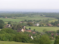
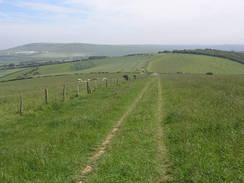
I did not stay by the pillar for too long, and soon set off to descend down to the car park and on along the Way. The views to the north were superb, although haze in the early morning sun. There was more cloud overhead than there had been yesterday, and in the distance I could see a blue hot-air balloon floating over some hills, and I found myself wondering if they were the North Downs. This stretch of path was quite busy with many runners and cyclists, and I was glad that I was walking and could therefore spend more time looking at the views. It took me a long time to reach the junction of paths immediately to the west of Black Cap, and I resisted the temptation to climb up the trig pillar at the summit a short distance away, as I had visited it on a previous walk.
Instead the South Downs Way doubled back on itself along a bridleway that was wedged in between hedges, which meant that it was not that interesting. It seemed to take an age for me to walk as far as Buckland Bank, where it turned once more, to head southeast downhill. The views here were much better, with a hedge on the right blocking views in that direction, but hat did not matter as the view ahead were quite expansive. A little over a mile later I reached another bend in the path, as it headed down towards Bunkershill Plantation, a small area of woodland. By now I had done over a third of the day's walk and my feet were aching, so I decided to stop for a rest. After shrugging my rucksack off I sat down in the long grass, took my boots off and listened to my Walkman for ten minutes as the sun blazed through the thin clouds overhead. I was surprised that no-one passed me as I was sitting down, as the section of path near Ditchling Beacon had been very busy, but the solitude was pleasant, and with my hat pulled over my face to protect me from the sun I could easily have gone to sleep.
Once I got going again my feel felt better as I descended the short distance to the Bunkhersill Plantation, where the path plunged into the trees before starting a steep climb uphill. The trees shaded me from the sun but also kept the wind off me, and I was soon sweating through what proved to be a tough few hundred yards. Once out of the trees the gradient slackened, and once over the top of the hill a steep descent took me down to the A27. I have been told that this part of the Way is relatively new, it previously having crossed the busy road further to the east by what was apparently a dangerous crossing. Looking at all of the traffic I was glad that a diversion had been made, and a bridge took me over the road and deposited me on the other side. It then doubled back for a distance, sandwiched between the road and a railway line, before diving through a bridge that led under the railway line.
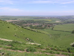
As soon as I was through the bridge the noise from the road abated, and I was greeted by a long but steady climb up back onto the Downs to the southwest of Lewes. It was a pleasant climb, and as I gained height the views got more expansive. The path levelled out, and what followed were a few miles of good, high-level walking, with Lewes and Kinston-near-Lewes clearly visible below. As the day was progressing the skies were getting clearer, and this made the views even better as I strolled along. Unfortunately on Ilford Hill the path underfoot became a long concrete track, and this soon had the undersides of my feet aching once again, and it was a relief when the Way left the track and started descending down towards a farm. The descent was gradual and seemed to last an age, and I was finding, whereas yesterday I had been in a great mood, today I was not on best form. Perhaps it was the fact that my feet were hurting, or the fact that I had walked this stretch before, but I could not wait for the day to end.
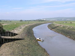
The path met the valley floor near a farm, and another long concrete track took me northeastwards towards a road; just before this was met a steep path took me up a little hillock (a diversion designed to avoid a busy road), and I then descended down a minor road towards Southsea. On a previous walk I had been fascinated by the little church, which has a round tower (unusual for this area), but today I was not in the mood to visit it, and I had set my sights on a rest a little further on. I therefore hurried down the road towards the bridge over the River Ouse, and stopped on the eastern bank of the river. The tide was out exposing large mud banks, and as soon as my boots were off I felt much better. It was a beautiful spot to sit for a rest, and nearby there were a couple camping, with a barbecue smoking merrily away. The bridge is an unusual swing bridge with the central pier being on one bank. It looked as though it had never opened for many years, and I found the structure to be strangely fascinating. I could literally have spent all afternoon on that river bank, but with the need to get to the end of the walk, catch the train back to Hassocks and then drive home, I had to press on.
During the break I had taken my boots off for a while, and my feet were feeling much better. A track led the short distance to Southsea station, where the gates are permanently closed, and so I had to use the adjacent footbridge to cross the tracks. I found my legs complaining from climbing the steps, and a short distance afterwards I reached the A26(T). Or at least, I nearly reached it. As I had walked towards the river from Southsea I had seen a bridge in the distance, and at the farm there was a path leading off to the right with fresh, clean stone underfoot. I followed this path, which led to a brand new and rather pleasing bridleway bridge over the road. This was an unexpected find, and I can only assume that it has been recently built, from its immaculate condition and the fact that there no signs marking out the diversion. When I got home I found a fascinating PDF document detailing how they chose to site the bridge.
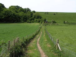
A small embankment with bare earth sides led down off the bridge, and onto a track that started winding up Itford Hill. This was quite a puff, but the views over the plains to the north and over the hills to the west were well worth the effort. This stretch of path was also very popular, and there was a stream of people walking and cycling downhill. I felt strange as I was the only person going uphill against a stream of people heading in the opposite direction. At the top the views became even broader, and I could clearly make out Newhaven and the coast to the south. It was an enjoyable climb, and on the way up I saw a hag glider to my right being prepared to set off, and on hills to the northwest there were any paragliders dotted in the sky.
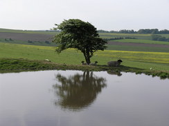
I soon reached the trig pillar at Red Lion Pond, an now-dry dew pond. The views from here were superb, and I stopped for a few minutes to take some photographs of the views. By now my feet were aching again, and although I was considering extending the walk by five miles by continuing on towards Alfriston, which would make the completion of the entire way easier. It was a very tempting alternative, but my feet were aching and, with the long train journey and drive ahead of me, I decided to head on down the bridleway a little further on. The walk along the ridge was pleasant, and just before the large masts of the radio station on Beddingham Hill were reached, I turned left to start heading down a by-way marked on the map. This was a semi-surfaced track, with an old tarmac surface having been badly broken up in places. The road dropped down steeply, before flattening out and heading north to the A27.
From the A27 there was a half-mile walk to Glynde Station, and this seemed to drag on forever, especially as the underside of my feet were aching considerably. This was made worse as I knew I had to press on as there was a train due soon, and so I avoided the obvious pleasures of the tempting pub in the village, which was replete with a lush green beer garden, and plodded on the short distance to the station. I arrived about twenty minutes before the train was due, and I sat down on a bench to wait for the train. It had been a good day's walk, and although my feet had let me down I was pleased that I had completed it. The train came on time, and after a long wait at Brighton for another train I arrived at Hassocks for the long drive back to Cambridge.
Directions
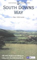
The walk is also covered in detail in the South Downs Way National Trail Guide, by Paul Millmore, ISBN 1 85410 966 9 published by Aurum Press Ltd.
The exception to this is at the start and end of the day. At the start of the day, leave Hassocks station by the main entrance and turn left to follow the line southwards to some steps. Use these steps to descend down to the B2116, and then turn left to pass under a railway bridge. Once through the bridge turn right and cross the road, and on the other side climb up some steps to join a path. This path runs for a mile southwards alongside the railway line, eventually ending at a road in Clayton. Turn left along this road for a few yards, and then turn left along a footpath that heads through a hedge before angling across a small playing field towards a building. Join another road, and cross this to access a footpath that initially head up a track before curving to the left and entering a file. Keep the hedge to your right as the path heads uphill steeply, eventually turning sharply to the right with the field boundary to head southeastwards towards the two windmills on the skyline. Once these are reached a path skirts to the let of them, before ending at a track. Turn left and head up this track for a couple of hundred yards until a junction with the South Downs Way is reached.
At the end of the day, continue walking northeast from the trig pillar on the Red Lion Pond along the obvious path towards the masts of the radio station on Beddingham Hill. Before the masts are reached a crossroads of tracks is reached by a fingerpost near the White Lion Pond. Here turn left, and start following a broken-up tarmac surface as it heads downhill. As it descends it settles on an northerly course, and runs for a mile to the A27. Cross the A27, and follow another road northwards into the village of Glynde. Pass the pub on the left, and the station is on the left down a flight of steps.
Distances
| From | To | Distance (m) | Ascent (ft) | Descent (ft) |
|---|---|---|---|---|
| Hassocks station | Jack and Jill windmills | 2.0 | 495 | 56 |
| Jack and Jill windmills | Ditchling Beacon | 1.9 | 295 | 102 |
| Ditchling Beacon | A27 | 5.4 | 371 | 974 |
| A27 | River Ouse | 6.6 | 853 | 1047 |
| River Ouse | Beddingham Hill | 2.4 | 600 | 23 |
| Beddingham Hill | Glynde station | 1.9 | 16 | 574 |
This makes a total distance of 20.2 miles, with 2630 feet of ascent and 2776 feet of descent.
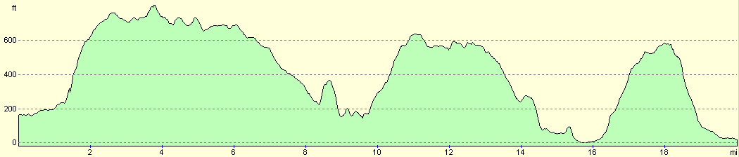
For more information on profiles, ascents and descents, see this page
Transport
There are regular train services from Glynde to Hassocks, changing at Brighton on the way. See the National Rail Enquiries for more information.
Disclaimer
Please note that I take no responsibility for anything that may happen when following these directions. If you intend to follow this route, then please use the relevant maps and check the route out before you go out. As always when walking, use common sense and you should be fine.
If you find any information on any of these routes that is inaccurate, or you wish to add anything, then please email me.
All images on this site are © of the author. Any reproduction, retransmissions, or republication of all or part of any document found on this site is expressly prohibited, unless the author has explicitly granted its prior written consent to so reproduce, retransmit, or republish the material. All other rights reserved.
Although this site includes links providing convenient direct access to other Internet sites, I do not endorse, approve, certify or make warranties or representations as to the accuracy of the information on these sites.
And finally, enjoy your walking!
This walk was mentioned in the following routes:
| The South Downs Way |
Nearby walks
| # | Title | Walk length (miles) |
|---|---|---|
| 298 | Beachy Head to Peacehaven | 16.7 |
| 299 | Peacehaven to Worthing via Brighton | 20.5 |
| 596 | Wivelsfield to Newhaven | 22.7 |
|
|

|