Walk #730: Avebury to Wayland Smithy
 |
 |
|
General Data
| Date Walked | 10/06/2006 |
| County | Wiltshire, Oxfordshire |
| Start Location | Avebury |
| End Location | Wayland Smithy |
| Start time | 09.45 |
| End time | 19.05 |
| Distance | 23.3 miles |
| Description | This walk followed the Ridgeway eastwards from near Avebury as it passes many fascinating archeological sites, from Iron-age times onwards. |
| Pack | Today I carried my 70-litre Craghoppers rucksack, including my Jack Wolfskin tent, sleeping bag and other camping equipment, although no cooking gear or spare clothes. With three litres of water the pack weight was about 15 kilograms. |
| Condition | I feel relatively okay, if tired, after this walk. Although my feet ached at times taking my boots off eased this, and by the end of the walk I could have easily walked further if I had needed to. It was a very hot day, but this did not affect me too much as I managed to drink lots of water. |
| Weather | The day was very warm, with a nice, cooling breeze that helped keep me cool. It was a largely cloudless day, and there was no sign of rain at any time, despite forecasts of thunderstorms later on in the day. |
| OS map | Landranger number 173 (Swindon & Devizes, Marlborough & Trowbridge) and Landranger number 174 (Newbury & Wantage, Hungerford & Didcot) |
 |
 |
|
 |
 |
|
Map of the walk
Maps courtesy of Google Maps. Route for indicative purposes only, and may have been plotted after the walk. Please let me have comments on what you think of this new format. For a detailed table of timings for this walk, please see the table file.
 |
 |
|
 |
 |
|
Notes
One of my plans for the year was to walk the Ridgeway, and I was aware that up to now, with nearly half of the year gone, I had nothing towards meeting this target. I wanted to go away walking this weekend and I was tempted to walk the rest of the South Downs Way, but as I had been down there last weekend I thought that I may try something else. On the map I had measured the distance of the western half of the Ridgeway to be about 45 miles, and this seemed like an achievable distance in a weekend's walking. The main problem was with accommodation; there is nowhere suitable to stay at the halfway point, and this had delayed me from doing this walk so far this year. However, as my knees are now giving me very little trouble, and the weather was forecast to be very good, I decided to try camping out instead of descending from the hills to find accommodation.
The train tickets to Swindon cost me a surprisingly large �53, and after buying the tickets on Thursday evening and packing on Friday evening, I awoke at 5.00 ready to walk to the station in Shelford to catch the train. I could have got one at 05.25, but I decided to give myself a little more time to wake up and to catch the 05.55 instead. This proved to be no bad thing, as I still managed to get the same train out of Paddington, and found myself dumped in Swindon before nine. There was a little wait for the bus service to Avebury, so instead of catching it at the station I walked through the town to the bus station, where I bought some batteries and waited for the bus.
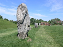
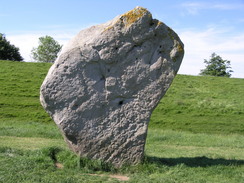
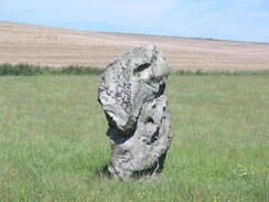
Once in Avebury I was stunned - as is always the case - by the megalithic stones that encircles the village. It is a frankly amazing sight, and I wandered about amongst the stones for a while was the sun beat down on me. The stones make a magical sight, especially when you consider that the entire village sits within the stones. I called in at the Tourist Information for a chat, and then walked down to the post office, where I bought yet more batteries and an ice lolly. While licking on the lolly I walked around the stones, heading for the start of the Avenue, a dual line of stones heading away from the village. As I walked amongst them I wondered why they were not built on a straight line; there is a distinct kink in the line, so much so that the adjacent road actually crosses the path, and a couple of stones are on the opposite verge. A short distance away on the other side of a hillock is the magnificent high mound of Silbury Hill, another sign of the importance that this area had for prehistoric man.
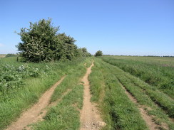
Once at the end of the Avenue, and having said hello to a herd of cows, I was relieved to find a permissive path that ran along the edge of a field, meaning that I would not have to walk along the road. This soon crossed the road, and angled across fields to reach the start of the Ridgeway National Trail at the side of the A4 on Overton Hill. I ran across the road to take a couple of quick photographs of The Sanctuary, a now-defunct circle of stones, the only reminder of which is some concrete posts that mark where the stones were until relatively recent times. Carefully crossing the road once again, I passed a signpost marking the start of the Ridgeway, and started a climb uphill, passing several barrows on the way, yet another sign of the prehistoric activity in this area.
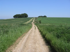
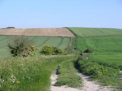
The Ridgeway started with a steady, gentle climb uphill, the surface not having been too churned up by the tires of four wheel drives. I could remember when I walked down this part of the track on a previous occasion on a stroll from Swindon to the Kennett and Avon canal, and the memories cheered me as the sun shone down. In the distance I could hear rumblings of thunder, which surprised me in the near-cloudless skies. These continued sporadically, and after a couple of minutes I realised that they were the distance sounds of tanks firing shells on Salisbury Plan to the south. I was amazed that the sound could carry this far, and I found myself wishing that I could watch the tanks in action. The ascent was nice and gentle, angling away from Avebury, which I could see down the slope to the west. I strained to see if I could see Silbury Hill poking above the slopes of Waden Hill, but the latter was too high to make the top of the famous mound.
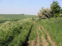
The path continued ascending northwards, and although the sun was blazing down I was not overheating too much yet. The path climbed onto Overton Down, and to the east there are some more Sarsen Stones, which are associated with the many burial mounds that are scattered around the landscape. The path approached Hackpen Hill and I ignored a trig pillar off in the field to the right, and continued walking on to cross a road above a carved white horse, which I sadly could not see. On the other side of the road there was a digger, and signs stating that the path was closed to vehicles during winter and spring, a measure to reduce the significant erosion and rutting of the chalk track that is caused during the wet seasons. The digger was sitting on top of a large pile of stones, and these were being used to repair the surface of the rutted track.
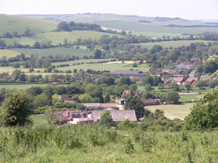
The views continued to be good, although as I walked the temperature solely increased. I had a chat on the phone to my girlfriend, Sencan, and this whiled away the next couple of miles, as the path descended to meet a road immediately to the west of Barbury Castle, an Iron age hill fort that has been reinforced many times over the years, even into the twentieth Century, when anti-aircraft guns were placed on the summit during the Second World War. It is a pleasant spot, and there were people picnicking next to the ditch, whilst others were flying kits overhead. The ringed bank that marks the fort is not too large, and I was soon outside it and walking the short distance to the car park and toilets, where I had joined the Ridgeway on a previous walk from Swindon.
Once I left the car park I soon reached the Ridgeway Caf�, a pleasant caf� situated right next to the trail. I was quite thirsty by this time as the drinking tube from my Platypus had been squashed by other contents of my pack. I stopped off at the caf� and dropped my rucksack off on a seat in the shade of an awning. There were some motorcyclists about, so after ordering a bacon sandwich I sat down and listened to their conversation as I sipped on some lovely, cold Ribena. Due to the discomfort in my feet that I had suffered on last Sunday's walk I took my boots off and gave my feet a chance to cool down in the shade. It was a very pleasant time, and although I was tempted to stay for longer I still had a way to go, and so with some reluctance I put my boots on, shouldered my rucksack and headed off.
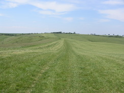
After following a track for a short distance from the caf�, the Ridgeway headed down a gentle slope called Smeathe's Ridge, which had good views to the north and south, and was in an airy and open position. The stiff breeze that blew throughout the day helped keep me cooler, and for the first time on the Ridgeway I was walking along grass instead of track. As the ridge eventually dropped down it joined a track and the views disappeared, and soon dropped me out unceremoniously on a road. The Way only stayed in this for a few yards, before taking a track enclosed by trees before ending at another road that took me down to the A436 road at Southend, to the south of Ogbourne St George. There us a pub in the village and it was tempting to walk the half-mile to it for a rest, but I was feeling fit and so I decided to continue on.
Just across the A436 was a cottage offset from the track, and on this was a tap, and I thankfully used this to have a drink and fill up an empty water bottle. I was getting through a fair amount of water in the heat, and the tap came in very welcome. The South Downs Way also has drinking water taps intermittently along its length, apparently because they are both bridleways and also because there are few streams on the chalk geology that is common on both walks. Having resisted the temptation to spray myself with water I headed uphill along a steep track that climbed up; I had to avoid a four wheel drive coming down at one point, and I was glad for the momentary rest I got when I stepped into the hedge. Eventually the gradient slackened and I could get my breath back as I walked, and after crossing a road the Way settled on a more northerly course on a good track. My feet were starting to ache by this time, and so I decided to take a little break; I walked on looking for somewhere sheltered, and when I reached a track crossing near Whitefield Hill I sat down on the verge in the shadow of some trees.
The spot was nicely in the breeze, and this washed over me and cooled me down as I took my boots off and lay back in the sun, listening to the Saturday Play on Radio Four, a quite dark play based on the life and death of Belle Elmore, the wife of Doctor Crippen. It was a captivating piece of radio, and I set back of walking with my mind on the twists and turns of the play. The track continued northwards for a while before the Way headed off towards Liddington Hill. There is a trig pillar on this hill fort, and I ser off to walk to it using the permissive footpath. However, after a couple of minutes I turned back as the path was taking me right around the edge of a field instead of heading directly towards the pillar. I did not want to extend the walk that much, so I made my way back to the Way, which headed downhill along a track before ending at a road. The Way followed this for a while, before turning right down another road that headed eastwards towards the M4, and then curved to head to Fox Hill.
It felt strange to be walking along roads, as I had done very little of it so far during the day. I found that I could walk faster on the road, but my feet were starting to hurt. At Fox Hill there is a pub, the Shepherds Rest, the only pub on the trail for the western half of the Ridgeway. As it was still relatively early in the afternoon, there was a hill to climb immediately afterwards and I wanted to fill up my water bottles, I decided to stop off for a drink. The England world cup match had recently finished (and I was glad that I had missed it), but people were still hanging around the large screen in one of the rooms, awaiting the next match to begin. I decided to miss this and went to sit by myself in another room. As soon as I entered the building I immediately overheated despite the fact that I was out of the sun; my circulation was still going strong, and it took me five minutes after I stopped walking to start cooling down. I ordered a pint of 6X and a pint of orange and lemonade, and sat down at a table to read a copy of the Times.
I spent a little under an hour in the pub, relaxing, reading and slowly supping at my pints. I had taken my boots off, and walking around on the carpet in just my socks seemed to cure any remaining aching from my soles. It felt very good to be out of the sun, and there was plenty of interest in the paper to read as I sat back and generally relaxed. Before I left the pub I got the landlord to fill up my water bottles, and I was sure as I walked out that there was enough water to last me the rest of the day and all through the night's camp. Outside the pub there were lots of people sitting, and I was relieved to find that the temperature had decreased markedly in the hour since I had entered. I therefore tackled the climb up Fox Hill with gusto, passing a sign marking the distances to places on this half of the Ridgeway.
Once at the top of the hill I found with delight that it was a wonderful early evening, the lessening heat being wonderfully counteracted by the stiff breeze, and my feet aching in no way after the rest. I literally yomped on, and soon realised that I had not yet eaten the sandwiches that I had made last night, I retrieved these from my pack and ravenously devoured the warm, squashed but undoubtedly delicious sandwiches with delight. At Ridgeway Farm I met another walker, a Canadian who had set off from Avebury yesterday. He was walking the entire way in eight days, and was going to camp in Bishopstone overnight (apparently there is a B&B there that allows camping). We chatted for a few minutes, and it was pleasant to talk to another walker. As we bade goodbye I noticed another drinking water tap at the farm - this one was not in the guidebook, and it would have saved me carrying the water up the hill.
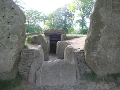
Throughout the day I had seen orange arrows attached to various objects by the track, pointing back in the direction that I had come. Some of these were accompanied by numbers that were decreasing and information about Maggies Centres the cancer charity, and as I passed one of these two men came walking towards me. One of these was strolling purposefully along but with a slightly tired gait, and I asked him what it was all about. It turned out that he was on the Maggie's megahike, a 15, 25 or 50 mile hike in 24 hours. One of the two men was doing the 50 mile walk, and was just over halfway through the walk. Wishing him well I set off, and before I knew it I reached Wayland's Smithy, a long barrow situated just off the path.
It had been my intention to spend the night in a narrow band of trees to the south of the path, but this did not seem too pleasant and, as I was feeling fit, I decided to walk on for another couple of miles until I found somewhere more suitable to erect my tent. As I passed a sign forbidding any fires or camping I was greeted the sight of the magnificent long barrow and, rising lazily above it, the smoke from a camp fire. On the right-hand side of the barrow were a couple of tents, and on the other a camp fire with a family sat around it. I climbed up onto the top of the barrow near the entrance and slowly walked down the spine until I was near the two tents, where two men were sitting. I started chatting to them, and they seemed like nice blokes. They had set off cycling from Avebury that morning, and after spending four hours in the Shepherds Rest watching the football match, had continued on to here
I sat down on the sloped side of the barrow and chatted to them for a while, and although there was still plenty of time for me to continue on, they invited me to put my tent up next to theirs, and I agreed. I was halfway through the two day's walk, I was tired, and it would be nice to have a chat for a while. I spent the next hour and a half chatting to them, and when they cycled down to the village to have a drink and meal I slowly put my tent up in the long grass next to the barrow. My little Jack Wolfskin tent looked tiny against their tents, and as it was still light I moved my inflatable mat onto the side of the barrow and lay down on it, reading as the sun slowly went down.
Directions
|
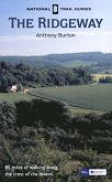
The walk is covered in detail in the Ridgeway National Trail Guide, by Antony Burton, ISBN 1 84513 063 4 published by Aurum Press Ltd. Click on the image to the right to go to the Amazon page for the book. The exception is for the first couple of miles of the day, where the path heads from Avebury to the start of the National Trail at Overton Hill. From the Red Lion Pub in Avebury turn left and start following the A4361 road southwards as it passes some of the Avebury stones. When the road leaves the stone circle at the southern edge of the village it turns sharply to the right; here continue straight on along the B4003 road as it runs alonside a stone avenue in the field to the right. After a mile, when the stone avenue ends, a footpath starts in the field on the right. This skirts the hedge in the field beside the road. This soon crosses the road, and heads through fields on the eastern side of the road, heading roughly southeastwards to reach the start of the Ridgeway beside the A4 on Overton Hill. |
 |
Distances
| From | To | Distance (m) | Ascent (ft) | Descent (ft) |
|---|---|---|---|---|
| Avebury | Overton Hill | 1.8 | 131 | 102 |
| Overton Hill | Barbury Hill | 6.2 | 577 | 272 |
| Barbury Hill | A346 at Southend | 4.1 | 154 | 551 |
| A346 at Southend | Pub at Fox Hill | 7.0 | 643 | 492 |
| Pub at Fox Hill | Wayland's Smithy | 4.2 | 312 | 223 |
This makes a total distance of 23.3 miles, with 1817 feet of ascent and 1640 feet of descent.
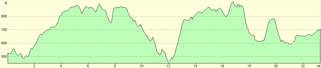
For more information on profiles, ascents and descents, see this page
Accommodation
I spent the night in my tent at Wayland's Smithy, a nice spot for a camp although not to be reccomeneded due to signs prohibiting overnighr camping. having said that, there were otherpeople camping there overnight, and it is a very pleasant spot to spend the night.
Disclaimer
Please note that I take no responsibility for anything that may happen when following these directions. If you intend to follow this route, then please use the relevant maps and check the route out before you go out. As always when walking, use common sense and you should be fine.
If you find any information on any of these routes that is inaccurate, or you wish to add anything, then please email me.
All images on this site are © of the author. Any reproduction, retransmissions, or republication of all or part of any document found on this site is expressly prohibited, unless the author has explicitly granted its prior written consent to so reproduce, retransmit, or republish the material. All other rights reserved.
Although this site includes links providing convenient direct access to other Internet sites, I do not endorse, approve, certify or make warranties or representations as to the accuracy of the information on these sites.
And finally, enjoy your walking!
This walk was mentioned in the following routes:
| The Ridgeway National Trail |
Nearby walks
| # | Title | Walk length (miles) |
|---|---|---|
| 73 | Devizes to Wooton Rivers | 14.9 |
| 570 | Swindon to All Cannings | 20.3 |
| 731 | Wayland Smithy to Goring | 23.0 |
|
|

|