Walk #570: Swindon to All Cannings
 |
 |
|
General Data
| Date Walked | 12/10/2003 |
| County | Wiltshire |
| Start Location | Swindon Station |
| End Location | All Cannings |
| Start time | 09.03 |
| End time | 15.34 |
| Distance | 20.3 miles |
| Description | This was a highly enjoyable walk, with some superb views and scenery for the majority of the day. |
| Pack | Today I carried my 30-litre Karrimor HotRock rucksack, which was filled with my packed lunch, waterproof leggings, water bottle and a couple of spare shirts, together with the usual assortment of odds and ends. |
| Condition | I am slightly tired, but otherwise fine, after this walk, and have no significant problems to report. It is good that I feel so fine after eight days without doing a walk. |
| Weather | I was hoping for good weather today, as I was expecting there to be some very good views. Fortunately it dawned dry, but there was cloud and I did not get to see much sunshine. There was no rain, but there was a gusting wind that was quite annoying when I was exposed to it on the chalk ridges. |
| OS map | Landranger number 173 (Swindon & Devizes, Marlborough & Trowbridge) |
 |
 |
|
 |
 |
|
Map of the walk
Maps courtesy of Google Maps. Route for indicative purposes only, and may have been plotted after the walk. Please let me have comments on what you think of this new format. For a detailed table of timings for this walk, please see the table file.
Notes
For various reasons I found myself spending the night with friends in Swindon, and so I decided that whilst I was in the area a walk would be a good idea. I had not done a walk for over a week (mainly due to food poisoning which kept me out of circulation for four days), and so I was exceedingly keen to try my legs out again. Although Swindon is hardly the most salubrious place in the world, just to the south are the chalk ridges and hills of The Ridgeway, and more importantly, Wiltshire's highest point, which I have yet to walk to as part of my walk to all the county highest tops in Britain. I therefore decided that I would walk to the top and then down to the Kennett and Avon Canal, which I have walked along before as part of my Land's End to John O'Groats circular walk.
The last Formula One grand prix of the season, the Japanese grand prix, was on from six this morning, and so I decided to watch this before doing the walk. It was a cliff-hanger, with two people capable of winning the championship, and so I was engrossed throughout the morning. Once the grand prix ended I said morning to our hosts and then set off to walk for a mile through Swindon to the railway station, where I was planning to start the walk. The town was exceedingly quiet before nine in the morning, and there were only a few people about. I must admit that I was far from impressed with the town - there was very little architecture of any note that I could see, and ugly concrete buildings towered overhead. Even the station had a tower block poised above it, making it a depressing and colourless area.
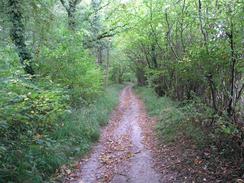
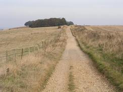
Because of this once I reached the station I was in no mood to hang around, so I started my GPS and set off walking. Using an A to Z I had planned the shortest route south out of the town, and this did not alter my views on the town. I was quite glad when I reached the southern outskirts and I started to see some greenery, although this also signalled my approach to the M4, the noise of which heralded its approach before I saw it. There was at least a good track underfoot that took me to the road and up the other side, before I had to walk south a long a road for three miles up towards the car park near Barbury Hill. Here I joined The Ridgeway National Trail, which I followed until it ended beside the A4 and gave me an exceedingly nice walk.
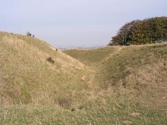
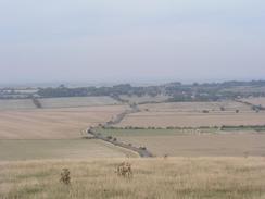
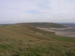
Barbury Hill Castle is quite an amazing structure, although castle may be a slight misnomer as it consists solely of an impressive deep earthen ditch and rampart. By this time I was quite hungry, having been tempted with bacon for breakfast, which I had unwisely declined. I had not put any food into my pack, and as I reached the car park by the castle the deliriously lovely smell of bacon hung in the air. I circled the car park twice but could not distinguish the source of it, and so depressed and with taste buds salivating I set off the short distance to the castle. The deep ditch and high rampart were very impressive, and where people's feet had worn it away the white chalk shone impressively in the light. I walked around the ramparts for a short distance and admired the expansive views north over the plains before setting off downhill along the Ridgeway. On the way I passed a perfectly circular cowpat that had been decorated by small pieces of chalk around its edge, giving a surprisingly attractive effect.
The Ridgeway is a National Trail that I have done short stretches of before, at the eastern end of the trail. I had been impressed by those stretches, and I was very impressed by the western end as I walked it today. The entire path followed tracks that were generally wide and firm underfoot, although in places the four wheel drives and motorbikes that occasionally passed me had churned up the surface quite badly. I am very much in two minds about green laners (people who drive and ride down byways in four wheel drives and motorbikes) - on one hand I can see the attraction of doing it and on the other they do churn up the tracks terribly, and it is not nice to have a Landrover come roaring up from behind you on a narrow and rutted section of track!
I soon reached the end of the Ridgeway beside the A4 opposite The Sanctuary, the site of an old (and now obliterated) stone circle, the only signs of which are concrete blocks in the ground marking the old position of the stones. The Sanctuary was at one end of the Avenue of standing stones that lead from Avebury, under two miles away. It is a massive shame that the low stones at The Sanctuary were flattened a couple of hundred years ago so that the field could be ploughed. For an image of what it may have looked like, I consulted my copy of 'The Modern Antiquarian', which has an engraving of it in 1724, a few months before it was cleared. The stones are low and nowhere near as impressive as those at Avebury, but the engraving reminds me in a way of the Nine Ladies stone circle in Derbyshire, one I know and love I looked around at The Sanctuary for a few minutes but there was not much to see and I found it to be a strangely depressing sight, and so I headed down a track into the village of East Kennett.
Another track took me up past Lurkeley Hill and on to Furze Hill, where a little area of scrubby woodland protected me from my first glimpse of Wans Dyke, and consequently I almost fell upon it at the top of the hill. Wans Dyke is a really impressive (a word that I have used a lot today) ditch and rampart structure that follows the edge of the hill westwards. The view of the dyke as it follows the ridge and from it to the north is spectacular, and it made for an incredibly enjoyable stroll. I diverted away from the path after a short distance to go and visit Wiltshire's highest point on Milk Hill; this is a very flat summit and it took me a few minutes to find the highest point. It turned out to be a very unimpressive county top, and the views were far better from the edge of the hill than the summit itself. I quickly made my way back to Wans Dyke, but when I got there a cyclist carrying his bike over a stile fell and badly twisted his ankle. After enquiring if he was okay a friend of his arrived, and I continued on down the Dyke.
I left the Dyke to go and visit the trig point at the top of Tan Hill - on the OS map this is marked as being 294 metres high, the same height as Milk Hill, the supposed highest point of Wiltshire a couple of kilometres to the east. I do not know which of these is the 'proper' count top, but neither is particularly good or noteworthy. From the trig point I headed south downhill past Rybury Hillfort on the flank of Clifford's Hill, and then on to the Kennet and Avon Canal. This linked today's walk with my land's End to John O'Groats walk, but I had to walk on south through the village of All Cannings to the church for the walk to end. Sam was waiting for me a short distance away by the cemetery, and when I arrived there I was very tired - I had walked well over twenty miles without a rest and had eaten no food all day.
Directions
This walk starts off at Swindon railway station. Leave the station and go onto Station Road, then cross this to gain access to Wellington Road. Walk to the end of wellington Road and then turn right onto Milford Street until a roundabout is reached, and then turn left down Fleming Way. When this too ends at a roundabout turn right to head south down Princes Street, passing Cranfield University on the way. At the end of Princes Street continue on down Clarence Street to gain access to Victoria Road that eventually ends at a roundabout with the A4361/A4289. At the roundabout turn left down Wood Street to gain access to the B4006 High Street. Turn right down High Street to a roundabout, where it becomes Marlborough Road, and then another roundabout where you head straight on along Pipers Way.
Pass a sewage works on the left as the road curves to the right, and then when Croft Wood is reached turn left along a footpath that heads southwards through the wood until it reaches a footbridge over the M4. The path continues southwards across the fields, crossing a stream and then skirting the western edge of Burderop Wood as it climbs up Ladder Hill and ends at a bend in the B4006 Brimble Hill Road. Join the B4006 and walk south along it until it curvs to the left, at which point continue straight on down another road that heads southwards for a couple of miles. The road passes Midge Hall and then climbs uphill past Burderop Down until a car park is reached near Upper Herdswick Farm.
At the car park turn right along another footpath that heads along the top of Barbury Hill, crossing over the mound of Barbury Castle before ending at a crossroads. Here my route joins the Ridgeway long-distance footpath as it heads southwestwards along a track, initially climbing uphill along Hackpen Hill and passing above a white horse. Continue on the Ridgeway as it heads southwards for another few miles past Avebury Down until the A4 is reached at a car park opposite The Sanctuary. Continue straight on across the A4, passing to the left of The Sanctuary down a green lane that crosses the River Kennett before reaching the village of East Kennett.
The lane joins a road that heads on through the village before turning right to head south along another track. After a short distance a Byway lead off to the left, heading south with Lurkeley Hill on the left before climbing up to reach Wans Dyke on Furze Hill. Turn right to walk westwards along the bridleway that runs along the top of Wans Dyke. After about a kilometre I left the path to the left to walk to the summit of the relatively flat Milk Hill, at 294 metres the highest point in Wiltshire, before making my way back to Wans Dyke. Follow it onwards for another couple of kilometres until another footpath leads off across Tan Hill to the left, heading south as it passes a trig point and a mount at Rybury on Clifford's Hill.
The path joins a bridleway just before it reaches a road opposite Cannings Cross Farm; cross the road and pass the farm along a footpath that head southwestwards to Woodway Bridge over the Kennett and Avon Canal. Cross the bridge and then continue straight on southwards along a byway that almost immediately reaches The Street in All Cannings. Continue on down The Street until it reaches the church at the south end of the village, where this walk ends.
Distances
| From | To | Distance (m) | Ascent (ft) | Descent (ft) |
|---|---|---|---|---|
| Swindon Station | Barbury Castle car park | 6.2 | 768 | 226 |
| Barbury Castle car park | The Sanctuary | 6.7 | 279 | 591 |
| The Sanctuary | All Cannings Church | 7.4 | 781 | 945 |
This makes a total distance of 20.3 miles, with 1828 feet of ascent and 1762 feet of descent.
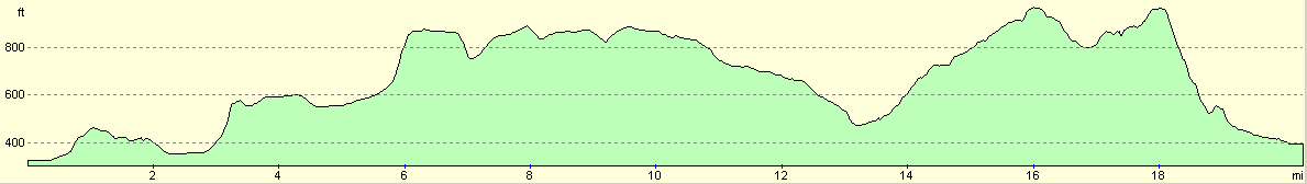
For more information on profiles, ascents and descents, see this page
Disclaimer
Please note that I take no responsibility for anything that may happen when following these directions. If you intend to follow this route, then please use the relevant maps and check the route out before you go out. As always when walking, use common sense and you should be fine.
If you find any information on any of these routes that is inaccurate, or you wish to add anything, then please email me.
All images on this site are © of the author. Any reproduction, retransmissions, or republication of all or part of any document found on this site is expressly prohibited, unless the author has explicitly granted its prior written consent to so reproduce, retransmit, or republish the material. All other rights reserved.
Although this site includes links providing convenient direct access to other Internet sites, I do not endorse, approve, certify or make warranties or representations as to the accuracy of the information on these sites.
And finally, enjoy your walking!
Nearby walks
| # | Title | Walk length (miles) |
|---|---|---|
| 72 | Bath to Devizes | 19.3 |
| 73 | Devizes to Wooton Rivers | 14.9 |
| 74 | Wooton Rivers to Kintbury | 16.4 |
|
|

|