Walk #569: Abbots Bromley to Stafford via Rugeley.
 |
 |
|
General Data
| Date Walked | 04/10/2003 |
| County | Staffordshire |
| Start Location | Abbots Bromley |
| End Location | Stafford Station |
| Start time | 09.24 |
| End time | 14.57 |
| Distance | 16.0 miles |
| Description | This was a highly enjoyable walk, and although not massively scenically interesting it was nice nonetheless. |
| Pack | Today I carried my 30-litre Karrimor HotRock rucksack, which was filled with my packed lunch, waterproof leggings, water bottle and a couple of spare shirts, together with the usual assortment of odds and ends. |
| Condition | I fell absolutely fine after this walk, aside from a little stiffness in my legs. |
| Weather | The day started off very grey, and although it was dry it was obvious that it had been raining overnight. It was quite cold first thing, and there were showers, some heavy, all day. In between the showers there were some sunny periods, and these helped me dry off easily enough. |
| OS map | Landranger number 128 (Derby & Burton upon Trent) and Landranger number 127 (Stafford & Telford, Ironbridge) |
 |
 |
|
 |
 |
|
Map of the walk
Maps courtesy of Google Maps. Route for indicative purposes only, and may have been plotted after the walk. Please let me have comments on what you think of this new format. For a detailed table of timings for this walk, please see the table file.
 |
Notes
It had been a couple of days since my last walk, and so I felt it was best if I did another walk (always a hardship, of course!). The weather was far from promising, but a soaking for one day does not really matter. I was staying with Sam at my sisters near Uttoxeter, so I felt like doing two of my planned walks in one day. These were (roughly) following the Staffordshire Way south from Abbots Bromley to Rugeley, and then following the Trent and Mersey and Staffordshire and Worcestershire Canals. This promised to be an interesting and easy day's walk, and I usually enjoy walking along canals.
Sam kindly dropped me off in Abbots Bromley, and I soon found one of the problems with walking the Staffordshire Way. I went to school very near to the way a little further north, and it is quite badly waymarked in some places. In he centre of Abbots Bromley it was not clear exactly where the way went, so I made my own way south of the village to where I could see the path went on the map. This was no real hardship, and I enjoyed the little diversion that was not too much longer than the official route. I soon reached the northern end of the dam that holds in the waters of the large Blithefield Reservoir. Annoyingly the path does not cross the dam, and instead heads past it so that I did not get a very good view of the lake. The path crosses over the River Blithe before having a baffling diversion southeastwards.
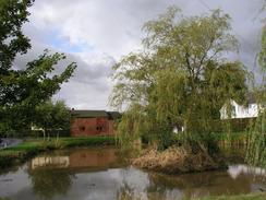
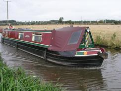
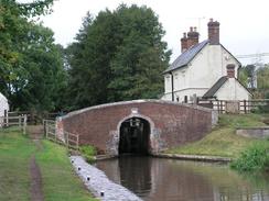
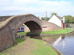
At Colton I diverted away from the Staffordshire Way and followed bridleways and footpaths towards Rugeley Trent Valley railway station, which I wanted to visit so that I could walk from there to Cannock and Wolverhampton on another day. I then headed back to the Staffordshire Way to the northeast of Rugeley, where it starts to follow the Trent and Mersey Canal. I was born at Stenson on the eastern end of this canal, and had never really explored it by boat or foot, and so it is nice to be seeing more of it. The walk along the canal was flat and very straightforward, but I enjoyed watching the narrow boats go past and seeing the anglers sitting almost motionless as they watched patiently for the merest ripple on the surface of the water. The locks also fascinated me - I had forgotten how narrow the narrow boat locks are, particularly as the last locks I have seen were the ship locks in northern Scotland. These were vastly larger than the narrow locks, which gave me the impression that I could easily jump from one side to the other, an idea I thankfully did not decide to put into practice! The canal skirted the southern side of the village of Colwich, where I could hear the gunfire from the army ranges on Cannock Chase, before curving around to head northwards past the grounds of the magnificent Shugborough Hall.
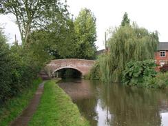
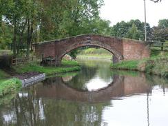
A short distance beyond Shugborough I left the Trent and Mersey Canal and joined the Staffordshire and Worcestershire Canal, of which I knew very little. It proved to be a pleasant enough walk, although the canal was far less busy than the Trent and Mersey had been, and I only saw a couple of narrow boats moving as I walked along. In a way I was quite thankful that the canal was so much quieter, and I enjoyed the peace and tranquillity until I approached the eastern outskirts of Stafford, where I left the canal and started following a footpath that ran along the southern bank of the River Sow. Initially this went across fields on the floodplain, but buildings soon started appearing on either side and I found myself in the centre of the city of Stafford. I walked past a couple of supermarkets and skirted the pedestrianised area to reach the railway station, where Sam was waiting for me in Mervan.
Abbots Bromley is a very nice little town, and is famous around the world for an annual event called the 'Horn Dance'. This is a strange dance involving six men carrying wooden effigies of reindeer heads with real reindeer horns embedded in them, dancing for twenty miles around the villages surrounding Abbots Bromley. It is an ancient dance, traditionally held on the Monday following the first Sunday after September 4 (it was performed during harvesting on August 24th until 1752, when the change to the Julian calendar brought it forward). The present dance dates from about 1125 when the local foresters obtained the hunting rights in Needwood Forest from the Abbot of Bromley. The Butter Cross is an old market cross dating back to the time of Richard III, and was probably built in 1339. It is quite an attractive little building, and it leads me to wonder what events it has seen over such a long span of years.
This walk has opened up a number of possibilities for future walks; it means that I can now walk south from Rugeley to Wolverhampton in one (long) day, and hence connect this walk up with the walk that I did along the canal network from London to Wolverhampton; and it also allows me to walk westwards towards Newport or northwards towards Stoke. I am not sure which of these I shall end up doing, or when I shall do them, but at least the options are there.
Directions
This walk starts opposite the Butter Cross in Abbots Bromley, which is one of the oldest buildings in the village. The first few miles of the walk follows the Staffordshire Way; initially, however, instead of following the way south of the village I walked eastwards for a hundred yards and then turned right up a track. This lead through a farmyard and then turned to the right, rejoining the Staffordshire Way. The track ends at a road; here the Staffordshire Way continues straight on across fields but I could not find it, so I turned to the left and walked southwards down the road instead. When the road curves to the left continue straight on down a track that leads towards the northern end of the dam of Blithefield Reservoir, rejoining the Staffordshire Way on route. By the sailing club buildings leave the track that runs down onto the dam and cross a stile to join a track that heads down to a bridge over the River Blithe.
O the other side of the bridge that Way turns to the left to head southeastwards away from the track, before turning to the right along a field boundary to a track. Turn right at this track to gain access to the southern end of the dam. When the track curves around to the right towards the dam continue straight on fir a short distance and then turn to the left uphill; the path passes near to Park Barn Farm before joining a track that becomes a road that ends at a T-junction in Stockwell Heath. At the junction turn to the left past a pond and then turn right along another road; after a short distance turn left and follow the Staffordshire Way as it skirts across fields to the west of the village of Colton. The Way eventually meets the road in Colton; here I left the Staffordshire Way by turning left along the road; at a phone box turn right down a track and then almost immediately turn left down a bridleway. Follow this southeastward for a little under a kilometre until it reaches a farm, and then turn to the right to head southwestwards across fields. The footpath meets a track, which is then followed for a short distance until it ends at the B5013 road next to The Yorkshireman pub, and opposite Rugeley (Trent Valley) railway station.
Turn right to head northwestwards along the B5013 road. When this curves to the right follow it part of the way around the bend and just before a house is reached on the right turn left along a footpath that heads northwestwards across a field before ending at a track. Turn left along this track as it climbs over the railway line and follow it as it swings to the right on the other side to reach a bridge over the canal. Cross the bridge, and once on the other side turn right to join the Trent and Mersey Canal towpath. Follow the Trent and Mersey canal for nearly three and a half miles as it winds its way northwestwards past Great Heywood and Shugborough. When the junction with the Staffordshire and Worcestershire canal is reached to the west of Great Heywood turn left to walk along the canal. For the first couple of miles the towpath runs along the southern side of the canal, but at Milford Bridge it crosses over to run on the northern side. Another mile and a half further on at St Thomas Bridge climb up onto the road and cross it to gain access to a footpath on the other side. This runs southwestwards for a short distance, passing under some power lines, before crossing a bridge and joining the southern bank of the River Sow. Follow the footpath westwards along the river until it reaches a road bridge, where it crosses over to run on the northern bank into Stafford. Follow the path beside the river through the centre of the town until the ring road is reached, and then turn left for a short distance to reach Stafford railway station, where this walk ends.
Distances
| From | To | Distance (m) | Ascent (ft) | Descent (ft) |
|---|---|---|---|---|
| Abbots Bromley | Rugeley | 5.4 | 233 | 390 |
| Rugeley | Stafford Station | 10.6 | 184 | 154 |
This makes a total distance of 16.0 miles, with 417 feet of ascent and 544 feet of descent.
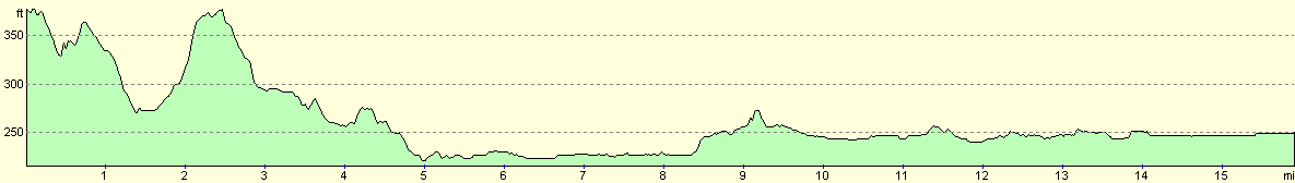
For more information on profiles, ascents and descents, see this page
Transport
Transport on this walk is a bit of a problem; fortunately my girlfriend dropped me off at the start and picked me up at the end. Otherwise the best options are probably bus services from Stafford to Uttoxeter and then Uttoxeter to Abbots Bromley.
Disclaimer
Please note that I take no responsibility for anything that may happen when following these directions. If you intend to follow this route, then please use the relevant maps and check the route out before you go out. As always when walking, use common sense and you should be fine.
If you find any information on any of these routes that is inaccurate, or you wish to add anything, then please email me.
All images on this site are © of the author. Any reproduction, retransmissions, or republication of all or part of any document found on this site is expressly prohibited, unless the author has explicitly granted its prior written consent to so reproduce, retransmit, or republish the material. All other rights reserved.
Although this site includes links providing convenient direct access to other Internet sites, I do not endorse, approve, certify or make warranties or representations as to the accuracy of the information on these sites.
And finally, enjoy your walking!
Nearby walks
| # | Title | Walk length (miles) |
|---|---|---|
| 171 | Doveridge to Abbots Bromley | 9.7 |
| 580 | Rugeley to Wolverhampton via Cannock | 19.5 |
| 584 | Doveridge to Longport | 21.7 |
|
|

|