Walk #568: York to Selby
 |
 |
|
General Data
| Date Walked | 01/10/2003 |
| County | North Yorkshire |
| Start Location | York Minster |
| End Location | Selby |
| Start time | 09.09 |
| End time | 14.23 |
| Distance | 15.2 miles |
| Description | This was a fairly boring plod following a cycle path along an old railway line, and was mainly notable as it was the first non-coastal walk for a year. |
| Pack | Today I carried my 30-litre Karrimor HotRock rucksack, which was filled with my packed lunch, waterproof leggings, water bottle and a couple of spare shirts, together with the usual assortment of odds and ends. |
| Condition | I feel absolutely fine after this walk, and I have no significant problems to report. My legs ached slightly at times, but this was to be expected after three days off. |
| Weather | It was slightly foggy at dawn, but this soon lifted to leave a bright, sunny day, with minimal clouds around to spoil things. Although it was slightly chilly to begin with, it soon warmed up and I had to take my fleece off, especially as there was little or no breeze. All in all it was a near-perfect day for a walk. |
| OS map | Landranger number 105 (York & Selby) |
 |
 |
|
 |
 |
|
Map of the walk
Maps courtesy of Google Maps. Route for indicative purposes only, and may have been plotted after the walk. Please let me have comments on what you think of this new format. For a detailed table of timings for this walk, please see the table file.
Notes
This walk is mainly notable for one reason - it is the first walk that I have completed since my coastal walk finished on Saturday. It had been three days since my last walk, which is by far the longest period that I have gone without a walk in a year, and so I was fairly keen to do a walk to stop my muscles from seizing up from lack of activity. Sam and I had stopped off in York on the way down to Derbyshire, and so it seemed like an ideal opportunity to do a walk. I was very aware that there is a Sustrans cycle path running between the two towns, which was built in the mid eighties on the line of the old East Coast Main railway line, which itself had been diverted westwards due to mining subsidence in the area. A railway walk promises to be flat and far from strenuous, so it seemed like an ideal choice.
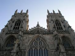
We parked Mervan at the park and ride to the north of York and then got the bus in to the centre. I said goodbye to Sam at the Tourist Information Centre, which I had to go into to buy a map for the walk (annoyingly I already have one of these, but it was at home), and then walked to the Minster so that I could start the walk. York Minster (a cathedral by any other name) is the largest such structure in northern Europe, and in he early morning light it looked spectacular - I do not think that I have ever chosen a better place to start a walk. It was just opening its massive oak doors to visitors, and I was sorely tempted to have a look around, but the prospect of a walk was more enticing.
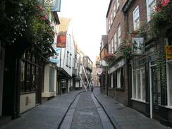
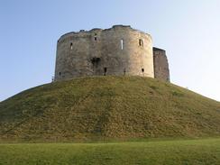
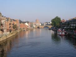
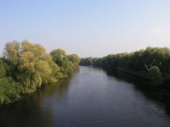
The route I had chosen took me through the centre of the city, past the narrow historic street of The Shambles (which was laid out in the 1400's), and on past Clifford's Tower to the Skeldergate Bridge over the River Ouse. York is a fascinating city, still surrounded by medieval walls, and I wish that there were more places like it in Britain as it is surely a better city than many others I could mention. There then followed a long walk south along the western bank of the river, initially following a cycle path and the Trans Pennine Trail, until the cycle path turns off to the right and the trail continues on alone. The walk beside the river was superb, and I enjoyed every second of it. On the approaches to Bishopthorpe it started to be spoiled by the noise of cars, which signalled the approach of the Bishopthorpe Bridge. This was a surprisingly elegant structure, with the two carriageways being carried over the river by two adjacent concrete spans that were curved in plan, and the ripples on the water reflected up onto the underside of the bridge in a very pleasant manner.
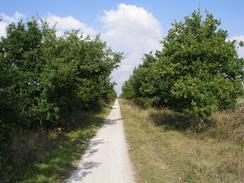
Bishopthorpe itself turned out to be a nice village, with a red-roofed village church and even a palace in it. A quick stop at the village post office to buy a packet of crisps delayed me by a few minutes, but I soon found myself at the bridge that carries the road over the course of the old railway line. North of the bridge the line has been built on, and I had to walk for a short distance through a housing estate to gain access to the cycle path. I joined this and followed it southwards, and I soon reached a signpost and a model of Jupiter. The signpost had directions to Mars (to the north) and Saturn (to the south). It turned out that York University had built a scale model of the solar system along the cycle path, with the planets and the distances between them to scale, meaning that the entire system was spread over ten kilometres! This is a superb idea, and seeing the planets every few kilometres improved what otherwise could well have been a flat and boring walk. The only downside is that I missed out on seeing the planets up to Mars, which were north of where I joined the cycle path. A little further down the path I reached the bridge that carried the railway over the River Ouse, and perched on top of this was a wire-frame sculpture called 'The Fisher of Dreams'. This was a very nice addition to the bridge, and it shows that the people responsible for the cycle path had not just made a path; they had also tried to make it interesting.
The walk along the cycle path was a straightforward plod, and was exceedingly flat. The surface underfoot was good, but I found it a relief when the trackbed ended at the Riccall bypass and I had to walk along minor roads through Riccall. On the southern side of the village the cycle path joined the A19 as it headed southwards towards Barlby, where again I followed roads through the village, which was not particularly memorable. By this time my thighs were feeling tight, and so it was with some relief that I reached the northeastern outskirts of Selby. Here I passed a large factory on the other side of the road, and even though I was walking along a path on the top of the flood bank I could not see the river, as there were decrepit and collapsing wharves between the river and the bank. The approach to the town was quite inauspicious, and I was glad when I reached the railway station, where I had planned to finish the walk. I had to walk on a little further to find where Sam had parked, but I was glad that the walk was over - the last half - especially the stretches along roads - had been quite boring, and I was in more of a mood to see more scenery.
Directions
The majority of this walk follows the route of the Trans-Pennine Trail, a long distance walk from Liverpool to Hull. I started off at York Minster in York, as this seemed to be a superb place to start any walk. From the Minster I headed southeastwards down High Petergate and Low Petergate until the latter ends at a square, and I then turned half-right to head south down The Shambles. At the end of The Shambles turn right to head down Pavement and then Coppergate until that ends, and then turn left to head southeastwards down Nessgate, Clifford Street and Tower Street, passing Clifford's Tower on the left. When the road ends turn right and head west across Skeldergate Bridge over the River Ouse.
On the western side of the bridge turn right and head down some steps to the road beneath the bridge, and then turn right to head under the bridge and head south along Terry Avenue. Continue on past a campsite on the right, and soon after this the path becomes pedestrianised and eventually ends. A cycle path continues on along the river when the road ends, and when this in turn ends by a new cycle bridge over the river continue straight on along the bank of the river along a footpath. This footpath heads south and passes under the large Bishopthorpe Bridge before leaving the river and ending at a road immediately to the north of Bishopthorpe. Turn left and follow the road south for a few hundred yards past the church, and then follow the road as it curves to the right through Bishopthorpe.
The road heads through the village and then curves to the left to head southwestwards over a bridge over an old railway line. Follow the road over the bridge, and on the other side turn right down a road that leads through a housing estate. After a hundred yards turn right and then immediately right again, doubling back on oneself, to follow a minor road through the housing estate until this ends by the overbridge. At the bridge continue straight on down the cycle path. The cycle path continues on for about six miles, initially heading southeastwards but slowly curving around to head south. The cycle path eventually ends beside the A19 in Riccall; here turn right down a minor road that curves through the village before ending back at the A19 about a kilometre further on. From here the cycle path follows the western side of the road as it heads southwards, passing Green Lane Farm before turning to the right to head along a minor road past Turnhead Farm and into Barlby.
Continue on through the road as it heads south for a couple of kilometres through Barlby, passing the school and eventually reaching a roundabout. At the roundabout turn right and follow he road westwards past a large factory to the left. Here I climbed up the small flood bank to the right and walked along the top of that as it followed the River Ouse westwards. Eventually the path ends and a minor road leads on back to the main road very near to a bridge over the River Ouse; here turn right to cross the bridge, and on the other side turn left to walk southeastwards for a hundred yards down a road alongside the river. When a low bridge under a railway line is met, turn right and walk alongside the railway line to the railway station, where this walk ends.
Distances
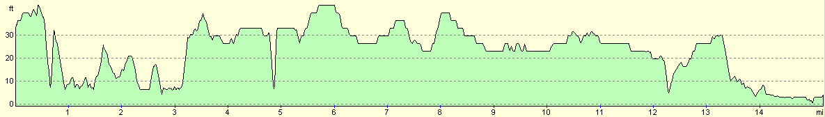
| From | To | Distance (m) | Ascent (ft) | Descent (ft) |
|---|---|---|---|---|
| York Minster | Bishopthorpe | 4.1 | 138 | 141 |
| Bishopthorpe | Riccall | 6.4 | 95 | 95 |
| Riccall | Selby Railway Station | 4.7 | 56 | 82 |
This makes a total distance of 15.2 miles, with 289 feet of ascent and 318 feet of descent.
For more information on profiles, ascents and descents, see this page
Accommodation
We spent the night at a campsite in Lincoln, which is so far away from the end of this walk that it is hardly worth mentioning it in relation to this walk.
Disclaimer
Please note that I take no responsibility for anything that may happen when following these directions. If you intend to follow this route, then please use the relevant maps and check the route out before you go out. As always when walking, use common sense and you should be fine.
If you find any information on any of these routes that is inaccurate, or you wish to add anything, then please email me.
All images on this site are © of the author. Any reproduction, retransmissions, or republication of all or part of any document found on this site is expressly prohibited, unless the author has explicitly granted its prior written consent to so reproduce, retransmit, or republish the material. All other rights reserved.
Although this site includes links providing convenient direct access to other Internet sites, I do not endorse, approve, certify or make warranties or representations as to the accuracy of the information on these sites.
And finally, enjoy your walking!
Nearby walks
| # | Title | Walk length (miles) |
|---|---|---|
| 1029 | Ebor Way: York to Wetherby | 23.3 |
|
|

|