Walk #580: Rugeley to Wolverhampton via Cannock
 |
 |
|
General Data
| Date Walked | 16/12/2003 |
| County | Staffordshire, West Midlands |
| Start Location | Rugeley Trent Valley Railway Station |
| End Location | Wolverhampton Railway Station |
| Start time | 07.50 |
| End time | 14.18 |
| Distance | 19.5 miles |
| Description | This was a fairly boring walk, the initial stretch to and past Cannock along roads, and the latter section along canal towpaths. Unfortunately there was not much on this walk that would make me want to repeat it. |
| Pack | Today I carried my 30-litre Karrimor HotRock rucksack, which was filled with my waterproof leggings, water bottle and a couple of spare shirts, together with the usual assortment of odds and ends. |
| Condition | Aside from one small blister on a toe on my left foot (the first blister that I have had in ages) I am absolutely fine after this walk, and I could easily have walked further if I had needed to. |
| Weather | Today was generally an overcast day, but fortunately there was no sign of any rain falling down from the cloud. However there was little sign of any sun either, and there was little wind to chill me. All in all it could have been a much worse, but also a much better, day for a walk. |
| OS map | Landranger number 128 (Derby & Burton upon Trent), Landranger number 127 (Stafford & Telford, Ironbridge) and Landranger number 139 (Birmingham & Wolverhampton) |
 |
 |
|
 |
 |
|
Map of the walk
Maps courtesy of Google Maps. Route for indicative purposes only, and may have been plotted after the walk. Please let me have comments on what you think of this new format. For a detailed table of timings for this walk, please see the table file.
Notes
Before I set off this morning I was well aware that I had not done a walk for nine days, and that attempting to do a twenty-mile walk might be slightly too ambitious. I was not too fussed, however, and the choice of walk seemed obvious; in the past I have walked along canals from London to Birmingham and Wolverhampton, and also from Doveridge to Rugeley, and I have wanted to fill in the missing twenty-mile gap for ages. I knew that unfortunately it would not be a classic walk, involving much road walking, and this was one of the reasons that I had delayed filling in the gap for so long.
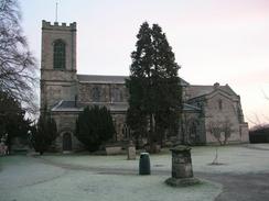
Today was getting near to the shortest day of the year, and so it was still dark when I set off for the half-hour journey to Rugeley. This worked out quite well, and the sun was just emerging from below the skyline when I parked my car in the free car park at Rugeley (Trent Valley) railway station. The early start meant that I was not in too much of a hurry, and so I took my time getting my kit together and putting it all into my rucksack, before putting it on my back and heading off down the road. I soon crossed over the Trent and Mersey Canal and found myself at the two churches in the centre of the town, divided by a road. The church on the right was a smart ruin; with only the tower and the chancel ends intact and nothing in the middle, whilst the one on the left-hand side of the road was still in use. I found it quite strange that the churches should have been so close, and wondered why one had fallen into disuse.
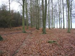
A long road plod then followed as I headed past the village of Slitting Mill and into Cannock Chase Forest. Although the road was not too busy I was glad when I found a path that led across the heath land parallel to the road, avoiding the hard walk on the tarmac. About halfway along I came across a sculpture in the woodland; it was made out of metal but had wood interweaved around it, and it looked as though it was slowly becoming part of nature. I studied this for a few minutes before heading off, and I soon reached a road junction by the forest centre. This was open but I was not in the mood for anything commercial, and so I headed off down the road. Again this was a long plod, and the scenery was not as good as I had hoped; Cannock Chase is supposed to be a beautiful place, but it looked fairly nondescript to me; it was nice, but nowhere as nearly as nice as people had told me. Then again, I did stick to roads and did not take one of the many paths through the chase, so perhaps I did not see it at it's best.
The road emerged from the forest and passed a large concrete communications tower at Pye Green, before heading for a couple of miles south into the centre of Cannock. This town did not impress me in the least, and I found no reason to linger and so I sped out westwards along roads. A small lane took me over a hill and led me out to the A5 at a place called Four Crosses. This was a much more hospitable area, and once I had waited a few minutes to safely cross the busy road I went to examine the Four Crosses Inn. This is partly an early Seventeenth Century timber-framed building, and it looked superb, although it was a shame that there were some more modern extensions to the building. From Four Crosses I headed off down the road, passing under the M6 before reaching the Staffordshire and Worcestershire Canal.
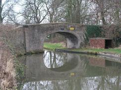
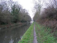
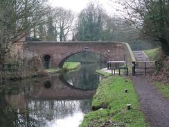
Once I finally reached the canal towpath I started to feel much better, and although the going was muddy I found it much better than walking along the road. Initially I followed a footpath that headed along the other side of the canal from the towpath, but when I reached Deepmoor Bridge I could cross over and join the towpath. There then followed a nice, although relatively undistinguished, walk south along the canal towpath. It was much more enjoyable than the walk along the road, and there was much more to see. Eventually I reached Autherley Junction, where the Shropshire Union Canal joins the Staffordshire and Worcestershire, and made my way south for the short distance to Aldersley Bridge and junction, where I turned left to start climbing up the long flight of locks into Wolverhampton.
This stretch of the walk was quite industrial, although as usual walking along the canal was far better than walking along roads, as the canal formed a green corridor through the suburbs. I passed under innumerable railway viaducts as I passed lock after lock, and I eventually found my way to the top basin, and joined up with the walk that I did a couple of years ago from Birmingham to Wolverhampton. I then had to find my way to the station in Wolverhampton, which I did with little bother; I asked a man who was sitting on a bench drinking a can of beer and he directed me the short distance to the railway station, which was clearly visible. On the way I passed the large brick-built Chubb Lock Works; a lovely building and very well engineered, although sadly it had been converted into offices. When I reached the station I went in, booked a ticket, and waited forty minutes for the train to Stafford, the first leg of the journey back to Rugeley.
This walk was hardly a classic walk, but I still quite enjoyed it; if it had been road walking the entire way then I may feel differently about it, but the long stretch of canal towpath walking made up for the dreary road walking. Having said that it is not a walk that I will be in a hurry to repeat any time soon; it was very much a walk filling in a gap, and not one done for any aesthetic reasons.
Directions
This walk starts off at Rugeley Trent Valley Railway Station, just to the north of the town. Leave the station car park and head down the short access road to the B5013 road, and then turn right along the road. It immediately passes under a railway bridge and reaches a bridge over the River Trent. Continue southwestwards along the road to a bridge over the Trent and Mersey Canal, and then onwards past two churches (one on either side of the road) until a road junction is reached. Turn right along this road and then immediately left down another road that heads southwestwards past a school. When the A51 is reached cross over it and continue on the road on the other side as it heads westwards past a school and heads up a light hill to a road junction in Slitting Mill. Here continue on the larger road as it curves to the right to head westwards; after a short distance an area of woodland starts on the left. Instead of walking along the road there is a rough path through the woodland on the left that parallels the road until a road junction is reached beside a visitor centre.
Here turn left and follow a road as it heads southwestwards across Cannock Chase. The road is quite straight except for a slight kink near Fairoak Lodge, until at Brindley Village car park it curves to the left to head south-southwestwards uphill past a large concrete mast at Pye Hill before descending for another couple of miles until the road ends at a T-junction with the A34(T). Here turn left and follow the road south for a few hundred yards to a roundabout by the bus station in Cannock. At this junction turn right along the B5012 road, and when this curves sharply to the right continue straight on for a few yards and take the first road off to the right. This road heads westwards, and then take the second road off to the left, which heads out of Cannock. Once it leaves the town the road becomes a narrow lane that heads over a little hill before descending to meet the A5(T) at Four Crosses.
Cross the A5(T) and pass to the left of the Four Crosses Inn down a road. After a few yards a junction is reached; here continue on the larger road as it heads southwestwards, crossing a bridge over an old canal before reaching a crossroads. Here continue straight on to the west, passing under the M6 bridge and past a pub; immediately after the pub turn to the left down another road that heads southwestwards for a few hundred yards until it ends at a T-junction. At this junction turn left to head south down another road; immediately past a lake on the right turn right down a footpath that heads beside the lake for a short distance to the eastern canal bank. From here the footpath runs along a track as it heads westwards to Deepmore Bridge (no. 75) on the Staffordshire and Worcestershire Canal. Cross the bridge, and once on the other side turn left to join the canal towpath proper.
Continue on along the canal as it heads in a rough southerly direction; after about five miles Autherley Junction with the Shropshire Union Canal is reached; continue on south along the Staffordshire and Worcestershire for about half a mile until Aldersley Junction is reached, and then turn left to head along the canal into the centre of Wolverhampton. The towpath is exceedingly easy to follow as it passes a series of locks, with the presence of suburban Wolverhampton increasingly encroaching onto the path. Once the Top lock and the canal basin in the centre of Wolverhampton is reached climb up onto a road and turn right to cross the canal by the road bridge. On the other side turn left and follow a road that climbs up past the superb brick-built building of the Chubb Lock Works to the bus station. At the bus station turn left and cross a wide road bridge to reach Wolverhampton railway station, where this walk ends.
Distances
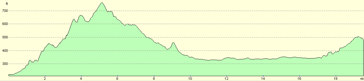
| From | To | Distance (m) | Ascent (ft) | Descent (ft) |
|---|---|---|---|---|
| Rugeley (Trent Valley) | Cannock bus station | 7.8 | 719 | 446 |
| Cannock bus station | Wolverhampton station | 11.7 | 371 | 384 |
This makes a total distance of 19.5 miles, with 1090 feet of ascent and 830 feet of descent.
For more information on profiles, ascents and descents, see this page
Transport
There are regular train services from Wolverhampton to Rugeley, changing at Stafford; this cost under three pounds, and took under an hour.
Disclaimer
Please note that I take no responsibility for anything that may happen when following these directions. If you intend to follow this route, then please use the relevant maps and check the route out before you go out. As always when walking, use common sense and you should be fine.
If you find any information on any of these routes that is inaccurate, or you wish to add anything, then please email me.
All images on this site are © of the author. Any reproduction, retransmissions, or republication of all or part of any document found on this site is expressly prohibited, unless the author has explicitly granted its prior written consent to so reproduce, retransmit, or republish the material. All other rights reserved.
Although this site includes links providing convenient direct access to other Internet sites, I do not endorse, approve, certify or make warranties or representations as to the accuracy of the information on these sites.
And finally, enjoy your walking!
Nearby walks
| # | Title | Walk length (miles) |
|---|---|---|
| 170 | Birmingham to Wolverhampton | 14.7 |
| 171 | Doveridge to Abbots Bromley | 9.7 |
| 569 | Abbots Bromley to Stafford via Rugeley. | 16.0 |
|
|

|