Walk #579: A circular walk from Leek, taking in The Roaches
 |
 |
|
General Data
| Date Walked | 07/12/2003 |
| County | Staffordshire |
| Start Location | Leek Market Street West car park |
| End Location | Leek Market Street West car park |
| Start time | 07.58 |
| End time | 14.00 |
| Distance | 16.1 miles |
| Description | This was a lovely walk, taking in The Roaches and the associated edges. |
| Pack | Today I carried my 30-litre Karrimor HotRock rucksack, which was filled with my waterproof leggings, water bottle and a couple of spare shirts, together with the usual assortment of odds and ends. |
| Condition | I had trouble with my right knee from the very beginning of today, and it continued to give me gip all day. It did not get worse until the very end of the walk in Leek, when I started limping slightly from the pain. I am not quite sure what I have done to it, but as it was hurting before I started the walk it must be a legacy of yesterday's walk on Kinder Scout. Aside from this I felt fine, and I have no other problems to report. |
| Weather | Today was sunny with only a few clouds, vastly different to yesterday's overcast skies. Unfortunately one feature it had in common with yesterday was the wind, which was quite fierce and chilly when I was exposed to it. The skies were clear however, and I could see for miles from high points in the land as there was little haze. |
| OS map | Outdoor Leisure number 24 (The Peak District - White Peak Area) |
 |
 |
|
 |
 |
|
Map of the walk
Maps courtesy of Google Maps. Route for indicative purposes only, and may have been plotted after the walk. Please let me have comments on what you think of this new format. For a detailed table of timings for this walk, please see the table file.
 |
Notes
After my little walk up Kinder Scout yesterday, I fancied doing a walk a little nearer to home. In the past I have been told that The Roaches, a gritstone edge on the western edge of the Peak District in Staffordshire, is brilliant walking and climbing technology. I had never walked there before despite the fact that it is only half an hour away from home, and so I decide that today's walk would be a circular one taking in The Roaches. Looking at the map I soon realised that in order to make a decent distance I would have to start and end the walk in Leek, and after that decision was made the walk more or less planned itself.
As soon as I got up this morning I realised that I had a problem, as my right knee was aching considerably whenever I bent it. It did not effect my driving, and I arrived in Leek soon after dawn. I was in no hurry to set off, and so I listened to the radio whilst I slowly put my boots and rucksack on. I had not been to Leek for years, and I found that it was not as nice as I remembered it - it seemed quite undistinguished in the early morning light. I found my way out of the town easily, and started heading along footpaths past Tittesworth Lake and on towards the gritstone edges, which glowed in the morning light.
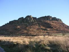
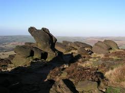
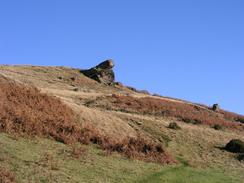
My knee was stiffening up as I walked along, and the walk across the fields was made less pleasant because of this. It was a relief when I reached the road in the village of Upper Hulme, which nestles below Hen Cloud (the first hill in the Roaches range). I decided to bypass Hen Cloud along the road, as I wanted to avoid what looked like a rough walk along the footpath on its flank. The southern end of The Roaches came into sight in no time, and I was pleased to see this it was complete with climbers making their way up a small rock face. This end of The Roaches comprise a series of wild, strewn boulders and cliff faces, a very pleasing view, and I can see why it is so popular amongst climbers, for whilst none of the climbs are particularly high there must be a massive number of routes and climbs of various difficulties.
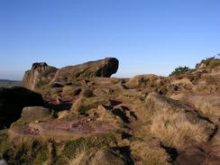
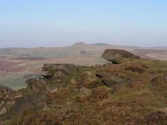
As soon as I passed Rockhall Cottage (also known as the Don William's Memorial Hut), I climbed up some stone step onto the top of The Roaches and was subjected to the full fury of the cold wind. The views more than made up for the discomfort, and they were extremely expansive. To the west I could easily make out Jodrell Bank (a large radio telescope in Cheshire), and the views in the other directions were also very good. I headed along the footpath along the top of the ridge, which wound around between rock outcrops, before eventually reaching the trig point at the summit. The views from the trig point were brilliant and I really wanted to take a panoramic photograph of them, but the wind was so strong that I did not fancy hanging around and getting chilled.
A quick descent took me down to the road near Bearstone Rock, and I started along the footpath that headed towards Back Forest. On the map the footpath headed along the base of the slope of the escarpment, but fortunately I found a concessionary path that headed right over the top. Although this exposed me to the chilly wind more, it was a far better walk and the views were again superb, and I enjoyed the walk. Another concessionary path took me on to the Hanging Stone, which I did not think was as impressive as the name suggests, and I then headed across fields and woodland to the road at Danebridge, on the Staffordshire / Cheshire border.
When I had planned the walk I was well aware that the western side of this walk was not going to be as nice as the eastern side, and so it proved. It was not a bad walk, however, and although I had some road walking to do these were mostly quiet and short stretches. In particular the descent down a minor road past Bearda led to a lovely little valley and private lake, a lovely spot that was only slightly spoiled by the steep ascent up the other side! The road continued on as far as Gun End, and a footpath then took me on southwards (excepting two very short stretches of road) as far as the farm at Fould.
Fould marked the end of the footpaths on this walk, and the last few miles were along roads, which fortunately were fairly quiet. I passed the pub at Abbey Green, avoiding the strong temptation to nip in for a drink, and made my way down to the A523 road on the outskirts of Leek. Here my right knee started hurting much more, and I found the last mile uphill into the centre of Leek to be quite trying, and I slowed down the pace to make it easier on myself. On the way into town I passed a massive mill on the right, the building, although still in use, looking quite sad and neglected. This set the tone for the last section of the walk, and I was glad when I finally reached the car.
When I got back home I parked my car and started emptying it of all the detritus that had built up over the weekend. However hard I searched, however, I could not locate the map that I had used today. Slowly the realisation dawned on me that I must have left it on the top of the car before I drove off from the car park in Leek. I therefore now find myself minus one map, and although it is annoying it is not the end of the world - the map was coverless and badly ripped, and had already been sellotaped up once already.
Directions
This walk starts off from the Market Street West car park in Leek, which is on Market Street opposite York Street. Leave the car park and turn right down Market Street for a few yards until the road ends at a T-junction with Derby Road. At the junction turn left and walk along the road to the roundabout in front of the clock tower. Turn left and walk up the road to a crossroads, and then continue straight on down Ball Haye Road. This passes a park and curves around to head northeastwards. When Tittesworth Avenue is reached turn left and follow it as it curves around to the right; a few yards further on a footpath leads off to the left. Follow this footpath for a few yards and then turn right down another footpath that passes a school before continuing on downhill along a track towards Wardle Barn Farm.
The path continues on a short distance from the farm and reaches a track. Turn left down the track for a few yards and then turn to the right, crossing a little footbridge over a stream before climbing uphill through Oaks Plantation with a field boundary to the left. At the top of the hill the footpath heads to the left through a hedge to the edge of the next field, and then turns to the right to head eastwards. After a few hundred metres the path turns to the left to descend down into a deep gully, before climbing up into fields on the other side. The path then runs northwestwards across a field before turning north across another field and reaching a farm track.
Turn left for a short distance along the track until Troutsdale Farm is reached. Cross a stile beside a gate and then enter the farmyard before turning to the right along another footpath that heads north for a few metres before turning to the right, and then the left to follow a field boundary northwards. Just before Lower Blackshaw Farm is reached the path goes across a hedge to the right, aiming across a field to a little plank bridge over a small stream. Cross the plank bridge and on the other side enter the farmyard and turn to the left to head north with a field boundary on the right. When an area of sparse woodland starts on the right turn right and follow a footpath that heads through and along the woodland before leaving it and turning to head northeastwards and ending at a road.
At the road turn to the left and follow it northwestwards for a few hundred metres until just past the farm at Middle Hulme, where a track called Whitty Lane leads off to the right. Take this track as it heads east-northeastwards, and when it curves sharply to the left continue straight on along a footpath across fields. The footpath diverts to the left around a barn before regaining the original track, and when this plunges down into a farmyard the footpath heads uphill to the left, skirting the edge of the farm before descending down some steps onto a road in Upper Hulme. Turn left and follow this road as it heads northwestwards past Paddock Farm, where it curves to head in a more northerly direction to the west of Hen Cloud.
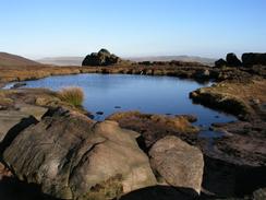
The road soon curves around to the left once again, and when this bend ends turn to the right into a field, and head diagonally across this field towards a little hut beneath the bluffs of the southern end of The Roaches. Join a track that leads towards the hut at Rockhall (which is partly built into the cliffs above), and then turn to the right up some steps. At the top of the steps turn to the left and head north-northwestwards for a few hundred metres before it climbs up to the right to the very top of the ridge. The footpath along the top of the ridge is very obvious as it heads north-northwestwards, passing a little pond at Doxey Pool, and it eventually reaches the trig point at the summit of The Roaches. Continue on past the trig point and head downhill along the track until it meets a road.
At the road continue straight on and take a footpath that runs northwestwards with a wall to the left. When a junction with a concessionary path is reached continue straight on along the concessionary footpath, which follows the top of the ridge along Back Forest. When this path meets another footpath, turn left for a few yards and then turn right, climbing a stile over a wall and taking a concessionary footpath westwards to the Hanging Stone. From the Hanging Stone a distinct path heads downhill for a short distance until it ends at a track. Turn right along the track and follow it westwards past Hangingstone Farm. Immediately past the farm a footpath leads off to the left and heads southwestwards across a field towards a wooded area.
Follow the path slightly to the left of a little dip in the field, and then go through a stile to the right to enter the wooded area. A footpath leads down to a little plank bridge over a stream and some marshy land, before climbing up through the woodland to the southwest. When the footpath reaches the outskirts of Danebridge head downhill to a road opposite a chapel. Turn left along this road and follow it southwards, passing the entrance gateway to Swythamley Park before descending steeply into a valley near a lake and then climbing up the other side. The road eventually ends at a junction with a larger road next to a post office; here continue straight on for a couple of hundred metres and when the road curves away to the right head straight on uphill along a track.
Follow this track as it heads uphill to the south, and when the track eventually peters continue straight on along a footpath that follows the edge of some woodland before ending at another road. Head straight along this road for a hundred metres, and at a right-hand bend turn left down another footpath that heads southwards for a few hundred metres until it ends at another road. Continue straight on southwards down this road for another few hundred metres, and then take a footpath that runs off to the right along a track. This track heads southeastwards along the edge of The Gun Plantation before heading downhill and ending at a road beside the farm at Fould.
At the road turn right and follow it as it curves to the left to head southeastwards, descending slowly down to Abbey Green. Continue on along the road as it crosses a large stream and ends at the A523 road. Turn left along the A523 road and follow it uphill to the southeast. It passes a large mill and at the top of the hill it curves to the left. When St Edwards's Church is reached turn to the right down another road into the centre of Leek; at some traffic lights turn left and follow this road eastwards to a roundabout beside the clock tower; here turn left down Derby Street and right up Market Street; the car park where this walk ends is a short distance up Market Street on the left.
Distances
| From | To | Distance (m) | Ascent (ft) | Descent (ft) |
|---|---|---|---|---|
| Leek Market Street West car park | Trig point on The Roaches | 6.7 | 1486 | 486 |
| Trig point on The Roaches | Leek Market Street West car park | 9.4 | 1076 | 2076 |
This makes a total distance of 16.1 miles, with 2562 feet of ascent and 2562 feet of descent.
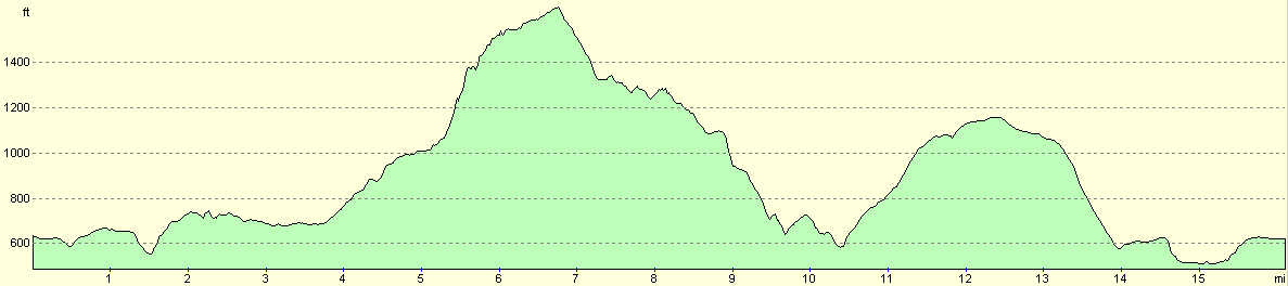
For more information on profiles, ascents and descents, see this page
Disclaimer
Please note that I take no responsibility for anything that may happen when following these directions. If you intend to follow this route, then please use the relevant maps and check the route out before you go out. As always when walking, use common sense and you should be fine.
If you find any information on any of these routes that is inaccurate, or you wish to add anything, then please email me.
All images on this site are © of the author. Any reproduction, retransmissions, or republication of all or part of any document found on this site is expressly prohibited, unless the author has explicitly granted its prior written consent to so reproduce, retransmit, or republish the material. All other rights reserved.
Although this site includes links providing convenient direct access to other Internet sites, I do not endorse, approve, certify or make warranties or representations as to the accuracy of the information on these sites.
And finally, enjoy your walking!
Nearby walks
| # | Title | Walk length (miles) |
|---|---|---|
| 1 | Shining Tor and Cat's Tor from the Cat and Fiddle pub | 7.2 |
| 582 | A circular walk from Hartington to Hollinsclough and Earl Sterndale | 14.8 |
| 614 | A circular walk from the Cat and Fiddle Inn | 17.2 |
|
|

|